Ahoy, readers! Here’s another “bonus” post for our ongoing series “How’d they get here?” If you need to catch up, the series began with our July 6, 2021 post Monday: Map Day! – How’d they get here? and continues from there.
I’m working on the next two (or three) more substantial installments of the series, metaphorically steaming against the wind through virtual piles of documents, books, and historical images. It’s going well, but taking a bit longer than I hoped. So while you’re waiting, how about another beautiful Great Lakes ship image, this time courtesy of the National Gallery of Art in Washington:
[American artist, 19th century], Steamship Erie, probably 1837, oil on canvas, National Gallery of Art, Gift of Edgar William and Bernice Chrysler Garbisch. Public domain. Click to open larger image in new window.
How the early settlers came to Mequon, c. 1835-1850 (part 2)
This is part 2 of a series focused on how our Mequon pioneers traveled to southeast Wisconsin in the early days of white settlement, between roughly 1835 and 1850. If you missed part 1, it’s here at Monday: Map Day! – How’d they get here?, plus a short post with bonus image at Steamboat’s coming!
From the late 1820s until about 1850, if you wanted to get from the settled American northeast to the open frontiers of the West, the fastest, safest, and cheapest way to get there was by water. Thousands of New Yorkers, New Englanders, Canadians, and overseas immigrants that had come from Europe to America’s eastern ports, found the Great Lakes route—west on the Erie Canal to Buffalo, and then by water through the Lakes to Chicago and Milwaukee—was their preferred route to new homes on the western frontier. And many of those settlers traveled on the newest, fastest craft afloat: the steamboat.
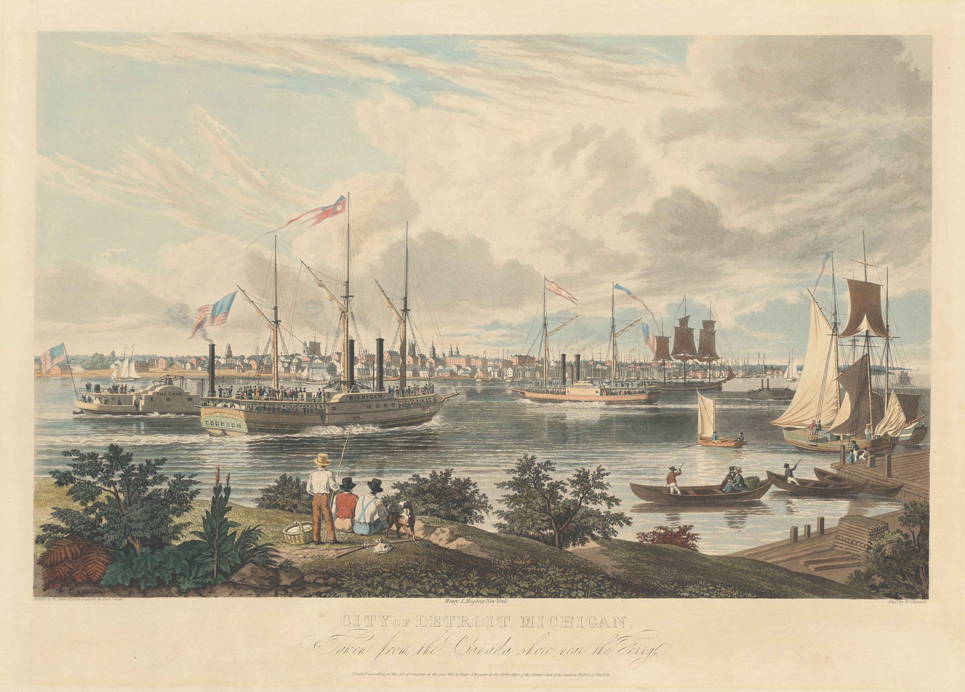
View of Detroit…1837
Here’s something really special for Clark House history lovers, a detailed drawing of the various kinds of sailing ships and steamboats as they passed by Detroit, Michigan on a sunny day in 1837, as seen from the Canadian side of the Detroit River. Take a close look; this is the view Peter Turck and his family—including daughter Mary, the future spouse of Jonathan M. Clark—would have seen as they traveled to Milwaukee in August of the same year1:
Bennett, William J., after a sketch by Frederick K. Grain, City of Detroit, Michigan. Taken from the Canada shore near the Ferry., hand-colored aquatint on engraving, ca. 1837. National Gallery of Art, Collection of Mr. and Mrs. Paul Mellon. Public Domain. Click to open larger image in new window.
UPDATED, February 11, 2024, to include a revised version of the annotated detail map of Ouisconsin, 1836. But for the full update—with additional notes and corrections—please see the most recent version of our discussion the Ouisconsin map of 1836 on our post of February 12, 2024. UPDATED, July 6, 2021, to answer a reader’s question: “Where was Jonathan Clark just before he went to Fort Howard?” Scroll down to Comments for the answer.
How the early settlers came to Mequon, c. 1835-1850 (part 1)
Clark House education director Margaret Bussone and our education team are putting together a project centered on how our Mequon pioneers traveled to southeast Wisconsin in the early days of white settlement, between roughly 1835 and 1850. I thought I’d help out by gathering some relevant materials and sharing them with the education team—and you—here on the blog.1
So this week we’re going to look at how the settlers found their way here, and how they traveled on land, lake, or river. Rather than writing lots of words about each map or image, I’d like to gather a whole bunch of useful items in each post and put them out there as resources for all to use. Later in the week, we’ll look at various modes of travel on land and on water. Today we’ll look at some maps.2 Some of these maps were readily available to our would-be immigrants, others might have been one-of-a-kind or otherwise hard to obtain.
An overview, The U.S. in 1834
When the following map was published in 1834, Jonathan M. Clark was finishing the first year of his three-year enlistment in the U.S. army. He was stationed at Ft. Howard, on the Green Bay of Lake Michigan, in what was then the civil District of Huron, a soon-to-be-outdated term for the western portion of the Michigan Territory.3
Mequon’s earliest settlers would be coming to lands that were poorly mapped and little understood by most European-Americans. The most this map could show—in a very general way—is where the “open” areas were for future migration and settlement.
Norris, William, and Daniel K Minor. Map of the railroads and canals, finished, unfinished, and in contemplation, in the United States. New York: Railroad Journal, 1834. Map. Library of Congress. Click to open larger map in new window.
Heritage Days, a Clark House summer favorite, returns on Saturday, July 17, 2021, from 12:00 noon to 3:00 pm. No admission charge, but donations gladly accepted. Come enjoy some 1848-style family fun!
It was an eventful weekend. Congress—acting with a speed and unanimity1 unusual these days—declared a new federal holiday to celebrate June 19th as Juneteenth National Independence Day, formerly known and variously celebrated as Juneteenth, Emancipation Day, or Black Independence Day. It has roots in the issues and events of the Civil War years that I’m currently blogging about, and I’ll have more to share about the history of our newest federal holiday in a future post.
Sunday June 20 heralded the arrival of summer, and the observance of Fathers’ Day. In honor of both, I took the day off from writing and spent some time with my family. Wishing you all the best for summer, 2021, here’s an evocative seasonal print from Jonathan and Mary Clark’s era…
It’s been an awfully dry spring in southeastern Wisconsin. Even so, the grass around the Historian’s house has gotten pretty tall and scruffy. Time to get out the mower and tidy up the yard.
I need to make a correction. In one of the previous posts of our Infrastructure! series, I wrote:
In early 1841, before the commissioners approved county roads Nos. 1, 2, and 3, there was already one federal road in the county. The Green Bay road was a federal road […]. It ran generally south to north, joining Ft. Dearborn in Chicago to […] Ft. Howard in Green Bay. Along the way it passed through a number of growing settlements including the three villages that would become Milwaukee, and the future towns of Mequon, Cedarburg, and Grafton.
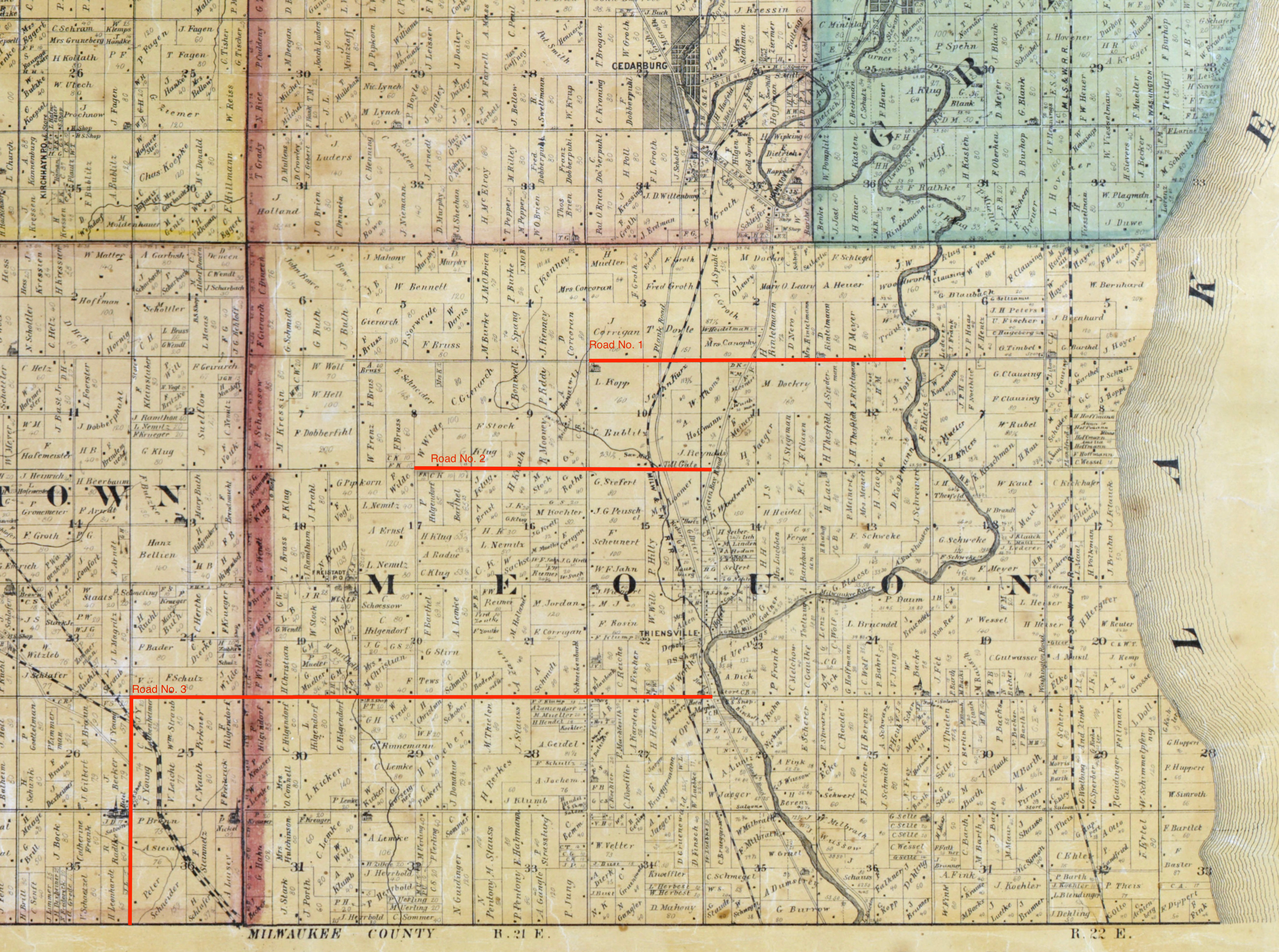
That’s almost accurate. To be precise, I should have said there was one federal road in the southeast corner of the county—the part that would become the towns of Mequon, Cedarburg and Grafton—the Green Bay road. But, if you consider the whole of old Washington county, there were not one, but two federal roads prior to 1841, the north-south Green Bay road and the east-west Dekorra road.
Both of these roads appear on the first map of Wisconsin Territory drawn from official government surveys, published in 1837. The two federal roads are indicated on the original map by closely-spaced parallel gray lines. On the detail below I’ve highlighted the then-existing eastern portion of the Dekorra road in blue, and the Washington county portion of the Green Bay road in green:
This is a revised and updated version of a post that originally appeared here on May 25, 2020. Please be sure to read the Notes & Updates, below, for new information.
Lest We Forget
Graves of Unknown Union Soldiers, Memphis National Cemetery, photo by Clayton B. Fraser, (Library of Congress), public domain. Memphis National Cemetery is the final resting place of Mequon’s Watson Peter Woodworth, and almost 14,000 of his Union Army comrades.
As we begin to recover1 from the worst pandemic in a century, a quick glance at the news will show that many Americans are celebrating this “Memorial Day Weekend” in our now usual way, as “the first day of summer.” Beaches and parks are open, stores entice customers with deals and sales, and people are crowding shoulder to shoulder in swimming pools and along ocean boardwalks.
But for many of us, Memorial Day remains rooted in its origins as Decoration Day. The first national observance was in 1868, when retired general John A. Logan, commander and chief of the Grand Army of the Republic—the Union veterans’ organization—issued his General Order Number 11, designating May 30 as a memorial day “for the purpose of strewing with flowers or otherwise decorating the graves of comrades who died in defense of their country during the late rebellion, and whose bodies now lie in almost every city, village, and hamlet churchyard in the land.”
This Memorial Day, let’s remember those Clark House family, friends, and Mequon neighbors who served in the Civil War, and what they fought—and died—for. The History of Washington and Ozaukee Counties (1881) lists these 65 volunteers from Mequon:
Another episode in our Infrastructure! series, a group of posts focused on the first government “improvements” in old Washington/Ozaukee county. If you need to catch up, start with Monday: Map Day – The First County Roads, 1841, then Marking Out the Roads, and our most recent post, Roads into the Woods, 1841, where we rediscovered the routes of old Washington/Ozaukee county’s very first roads.
First federal and county roads
In early 1841, before the commissioners approved county roads Nos. 1, 2, and 3, there was already one federal road in the county. The Green Bay road was a federal road, cut by the troops of the U.S. army’s 5th regiment. It ran generally south to north, joining Ft. Dearborn in Chicago to the regiment’s headquarters at Ft. Howard in Green Bay. Along the way it passed through a number of growing settlements including the three villages that would become Milwaukee, and the future towns of Mequon, Cedarburg, and Grafton. On the map below the Green Bay road is west of and occasionally parallels the Milwaukee River. It is sometimes labeled Green Bay Road, and sometimes—in the southern part of this map—Plank Road (the planking came later, in the 1850s).
Mapping out the first three Washington/Ozaukee county roads is not difficult. The proposals by the road supervisors, as recorded in the official minutes1, were quite precise. Clear starting and ending points were given, using the standard terminology of towns, ranges, sections, quarter sections and so on, and the lengths of each proposed road had been precisely measured in miles, with fractional miles given as a number of additional chains, rods or links. A map of those first three roads—superimposed on a later map of Washington and Ozaukee counties from 1874—looks like this:
Our Infrastructure! series— a short group of posts focused on the first county government “improvements” in old Washington/Ozaukee county began (almost a month ago!) with Monday: Map Day!, discussing the 1841 appointment of the first county road supervisors and the organization of the county’s first seven road districts. That was followed up with a discussion of surveyors, their tools, and Jonathan M. Clark’s experiences as a military road builder. Today we’ll take a look at the first few roads laid out and built in old Washington/Ozaukee county in early 1841.