I need to make a correction. In one of the previous posts of our Infrastructure! series, I wrote:
In early 1841, before the commissioners approved county roads Nos. 1, 2, and 3, there was already one federal road in the county. The Green Bay road was a federal road […]. It ran generally south to north, joining Ft. Dearborn in Chicago to […] Ft. Howard in Green Bay. Along the way it passed through a number of growing settlements including the three villages that would become Milwaukee, and the future towns of Mequon, Cedarburg, and Grafton.
That’s almost accurate. To be precise, I should have said there was one federal road in the southeast corner of the county—the part that would become the towns of Mequon, Cedarburg and Grafton—the Green Bay road. But, if you consider the whole of old Washington county, there were not one, but two federal roads prior to 1841, the north-south Green Bay road and the east-west Dekorra road.
Both of these roads appear on the first map of Wisconsin Territory drawn from official government surveys, published in 1837. The two federal roads are indicated on the original map by closely-spaced parallel gray lines. On the detail below I’ve highlighted the then-existing eastern portion of the Dekorra road in blue, and the Washington county portion of the Green Bay road in green:

Detail showing Washington County and highlighting approximate routes of federal Dekorra road (blue) and federal Green Bay road (green) from Topographical map of Wisconsin Territory / compiled from the Public Surveys on file in the Surveyor General’s office … by Samuel Morrison, Elisha Dwelle [and] Joshua Hathaway, engraved by Doolittle & Munson, 1837. American Geographical Society Library Digital Map Collection, University of Wisconsin–Milwaukee. Click here for a link to the full map at UW-M and its complete bibliographic information. Click map to open larger image in new window.
The Dekorra road
We went into some detail on the Green Bay road in our earlier post. The 1881 History of Washington and Ozaukee Counties […] Illustrated,[1] has more information on both of the county’s early federal roads:
The first roads were surveyed by the Government soon after the Menomonee treaty[2]. The military road running east from Dekorra, thence across the State to what is now Port Washington, was known as the “Dekorra road.” It was opened by Gen. Dodge in 1832 or 1833. It entered the limit of the county in what is now the town of Addison, the road running on the section line between Nos. 7 and 18, and passed through West Bend, Trenton and Saukville to Port Washington.[3]
The ” Green Bay road” was surveyed in 1832 and 1833, from Chicago to Green Bay, through what is now the lake shore tier of towns, and ran through what are now the towns of Mequon, Grafton, Port Washington and Belgium.
These were the earliest and only roads surveyed in the county before 1835, and were merely blazed[4] through by the engineers prior to that time. The Green Bay road was not cut out north of Milwaukee till 1836-37; during those years, it was grubbed out, two rods in width[5] for a few miles, and cut through to Port Washington in 1839. No bridges were built except of the most primitive kind, of the trees felled on the route. A well-trodden Indian trail between Milwaukee and Green Bay was the only passable road through the country along the lake shore prior to 1840, and up to 1844, after roads were quite common in that region the western and central settlers came in to their claims on the well-defined trails left by the Indians.[6]
On the 1837 map, only the eastern part of the route of the Dekorra road is shown. It begins at “Sauk Harbor” (now Port Washington), passes through the county’s first white settlement, “Sauk Ville” (Saukville), and continues generally westward from there. When completed, the Dekorra road would end at the Wisconsin River, joining Fort Winnebago (near modern Portage) with the eastern part of the Wisconsin Territory, including—via the Green Bay road—Fort Howard in Green Bay and Fort Dearborn in Chicago.
On this 1837 map, the westbound Dekorra road appears to split into two roads when it meets the north-south line dividing T11-N, R21-E and T11-N, R22-E (above the “T” in the word “Washington”). The road that continues due west from there is the continuation of the Dekorra road. Parts of the original Dekorra road are still in use as Wisconsin state highway 33.
County “road atlas,” c. 1841
In early 1841, newly independent Washington county began to survey and clear a series of roads to connect the increasing number of white settlers moving into the southeast corner of the county. The federal government had already marked out and begun to clear two federal roads, connecting Chicago with Green Bay and Sauk Harbor (Port Washington) with Dekorra (near Portage). The first three county roads would run mostly east-to-west. The new county roads intersected with the federal Green Bay road to form the beginning of a network of roads connecting the settlers with each other and the outside world.
It’s likely the original county commissioners and road supervisors—including Jonathan M. Clark—would have used a copy of the 1837 map of Wisconsin Territory to ponder and record their land-use decisions. They may have marked the new and existing roads on it, making a sort of “road atlas” for early-1840s Washington county, perhaps something like this:
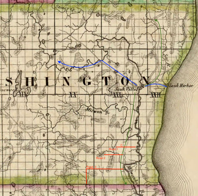
Detail showing Washington County and highlighting approximate 1837 routes of federal Dekorra road (blue) and federal Green Bay road (green) and first three county roads (1841), from Topographical map of Wisconsin Territory / compiled from the Public Surveys on file in the Surveyor General’s office … by Samuel Morrison, Elisha Dwelle [and] Joshua Hathaway, engraved by Doolittle & Munson, 1837. American Geographical Society Library Digital Map Collection, University of Wisconsin–Milwaukee. Click here for a link to the full map at UW-M and its complete bibliographic information. Jonathan M. Clark farm indicated with red letter “C.” Click map to open larger image in new window.
The federal roads, as they existed in 1837, are highlighted, the Dekorra road in blue and the Green Bay road in green. The first three Washington county roads, as approved by the supervisors in February, 1841, are marked and labeled in red. I’ve omitted county road No. 4, which we discussed and tentatively mapped elsewhere. As mentioned in that post, the route of this fourth road is not precisely described and I’m not certain it was built as proposed. So I have left it off this map.
Location! location! location!
The Jonathan Clark farm, the SE quarter of section 3, T9-N, R21-E, is marked on our “road atlas” with a red letter “C.” As you can see, from the county’s earliest days of white immigration and settlement, Jonathan Clark—and his neighbors and family in the Bonniwell District—were perfectly positioned to take advantage of the new roads. They would soon have easy (or, at least, easier) access to farms, mills, businesses, shops and supplies, local and federal government offices, and transportation and markets for their farm products and manufactured goods.
As the old joke goes: what are the three most important factors when buying a new home? Location! location! location! And JMC and his early neighbors did very well on that account.
Next time: we wrap up our Infrastructure! series and then we’ll move on to one of our most head-scratching Clark House mysteries: What happened to Henry?
See you soon. Be well.
___________________________________
NOTES:
- History of Washington and Ozaukee Counties, Wisconsin […] Illustrated, Chicago, Western Historical Co., 1881, pages 313-314.
- The treaty referred to here is the Treaty of 1831, one of a series of treaties between the federal government and the Menominee Indians. For an overview of the government’s dealings with the Menominee—beginning with the peace treaty at the end of the War of 1812—take a look at this article from the Milwaukee Public Museum. For current information on today’s Menominee people, a good place to begin is the tribe’s official website.
- The 1837 map of the surveyed portions of the Wisconsin Territory indicates that the route of the then-unfinished Dekorra road was generally cut—in old Washington county—from the east to the west. The road eventually ran through the indicated townships, i.e., T11-North, ranges, 22-, 21-, 20-, 19- and 18-East, and westward to Dekorra and the Wisconsin River.
- To “blaze” a trail or road meant to simply mark the route by making blazes, usually axe cuts in the bark of trees along the route. The phases of road construction outlined in this paragraph are surveying and blazing (marking) the route, followed by grubbing out, which involved cutting major trees and clearing most brush, but usually leaving short tree stumps along the way. “Cutting” a road is sometimes synonymous with “grubbing out,” or may mean a more thorough clearing of the route; which of these is meant here is not clear.
- Two rods equals 33 feet in width. See Note 1 of our April 26, 2021, Monday, Map Day! for more details on standard surveyor’s measurements, including the rod, link, and chain.
- This final sentence is confusing. I suspect the author meant something like (my additions in bold): A well-trodden Indian trail between Milwaukee and Green Bay was the only passable road through the country along the lake shore prior to 1840, and even as late as 1844, after roads were quite common in that eastern region, the western and central settlers in the county came in to their claims on the well-defined trails left by the Indians. What do you think?
- On this 1837 map, the westbound Dekorra road appears to split into two roads when it meets the north-south line dividing T11-N, R21-E and T11-N, R22-E (above the “T” in the word “Washington”). The road that continues due west from there is the continuation of the Dekorra road. Parts of the original Dekorra road are still in use as Wisconsin state highway 33.
- Until 1853, old Washington county included the townships that would later split off into Ozaukee county. Confused? see Where are we? for clarification.

Pingback: “J. M. Clarke” – Town Supervisor, 1846 | Clark House Historian
Pingback: Stuff Happens – on a sleigh ride! | Clark House Historian