Lately, I’ve been spending a lot of time looking through digitized historical newspapers, trying to fill in some of the missing pieces of the Clark House story. In the process, I’ve managed to discover some unique and important information about the Clarks, Turcks, Bonniwells and their neighbors. And I’ve also run into a lot of off-topic but fascinating tidbits about daily life in Wisconsin during the Clarks’ era, such as this random bit of history:
Hello, readers! Sorry for the long blog silence. I hope you are well.
It’s been a busy summer at my house, filled with the usual demands of job, summer garden chores, lots of behind-the-scenes history research and, alas, an unexpectedly large number of mundane but unavoidable tasks, most of which are now behind me.
I have a backlog of half-written posts to finish and share with you. In the meanwhile, I hope you enjoy this photo.
Cedar Creek, looking north from the Columbia Road bridge, Cedarburg, Wisconsin. Photo credit: Reed Perkins, July, 2022.
The view looks north along Cedar Creek from near the historic Cedarburg Mill, about two miles north of the Jonathan Clark House. Turn off the electric lights, and this is a view that the Clark family would have known well.
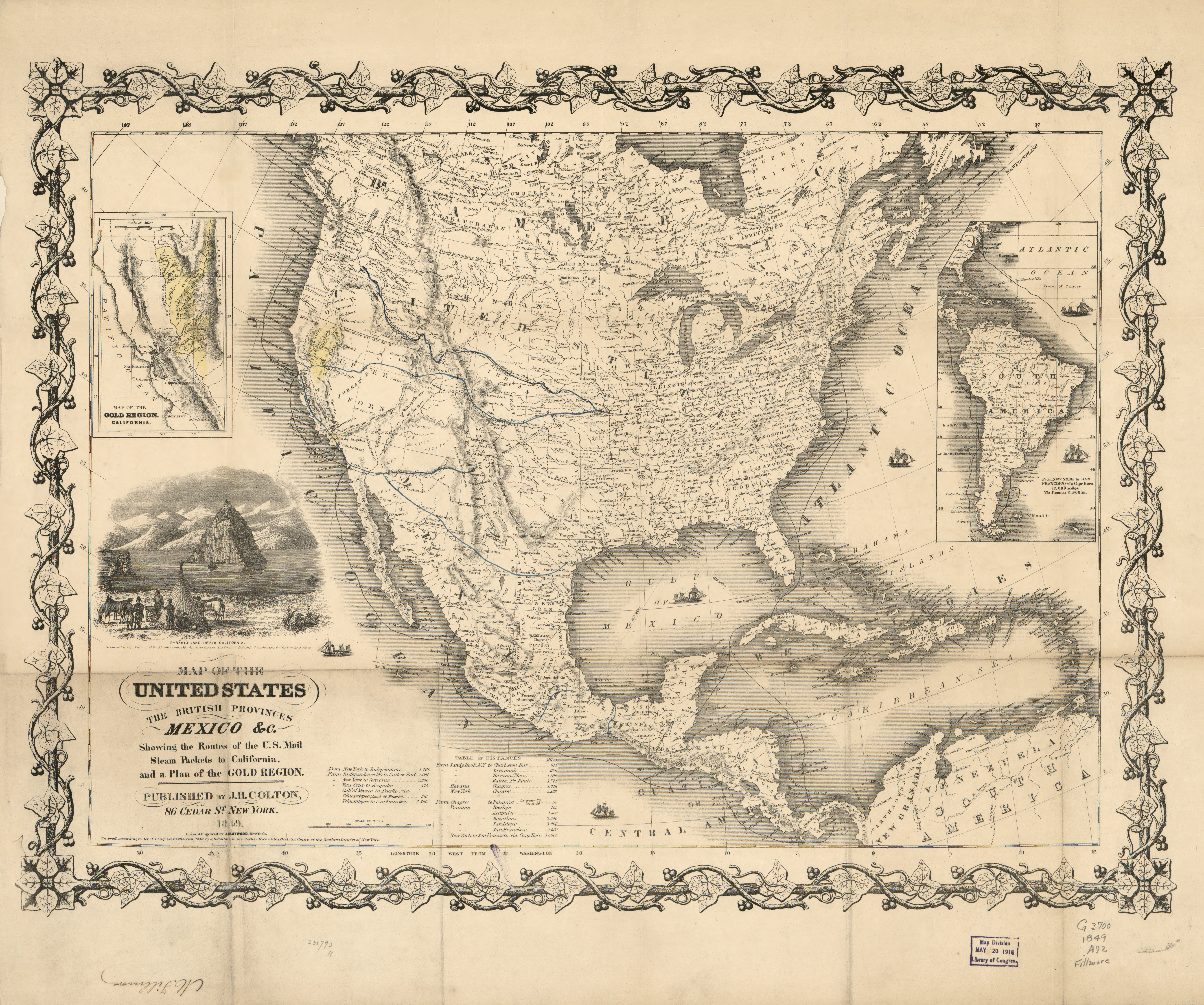
I love a great map, and today’s example is particularly fine in several respects: as a detailed view of our hemisphere at a particularly dynamic moment in U.S. history, as an excellent example of mid-19th-century cartography, and—as we’ll see in our next post—as a clear illustration of how members of Mequon’s Bonniwell family made their way to and from the California gold fields in the heady days of the early Gold Rush of 1849 and 1850.1
Gold! where it is and how to get there, 1849
Atwood, John M., Map of the United States, the British provinces, Mexico &c.: showing the routes of the U.S. mail steam packets to California, and a plan of the Gold Region. New York: J. H. Colton, 1849. From the collection of Millard Fillmore. Library of Congress.
I’ve published some great old maps on Clark House Historian, and this is one of my favorites. In our next post, I’ll annotate a copy of this map to illustrate the Bonniwell’s Gold Rush travels in 1849 and the early 1850s. But today I’d like to show the map as it was in 1849, with all its “extra features.” I recommend you begin by clicking the map image, above, which opens a much higher-resolution copy of the map in a new window (FYI, this may take a few seconds; it’s a big, detailed image).
Summer has finally settled in here in Wisconsin, and the Jonathan Clark House is ready to host you once again on Saturday, July 16, 12pm – 3pm to enjoy all the old fashioned fun in the very spirit of the season for the second installment of our summer series event Heritage Days!
In addition to our favorite features, our special attractions for July include:
Jonathan Clark House Museum, pantry area, June 29, 2022. Photo by Reed Perkins.
Yesterday was the annual “Pie on the Patio” fundraising event for the Jonathan Clark House Museum. I made the drive up to Mequon and had a great time visiting and talking history with many old—and new—Clark House friends.
I’m taking a bit of a break and have nothing new for you today. I have been doing a good bit of garden work around the house, and that reminded me of this post from April, 2021. Now we’re just finishing the first week of June, 2022, and it’s almost summertime. In southeastern Wisconsin the first spring flowers are done, and the next round of blossoms have been blooming for weeks. The tomato, bean and pepper seedlings are in the ground and doing nicely (although the rabbits have been nibbling on far too many green bean sprouts), and the roses are beginning to unfold. So even though this was originally an early-spring essay, I hope you enjoy this garden-themed repost from last year.
Planning the garden
It’s early April, and the growing season is not far off. For a farmer like Jonathan M. Clark, it’s a little early yet for plowing and sowing, but not too early to make plans and sharpen the tools. For a farmer’s wife, like Mary (Turck) Clark, it’s not too soon to think about the farm garden, its crops and layout.
I don’t know if Mary and Jonathan were regular readers of the popular and affordable farmers’ almanacs of their era; I wouldn’t be surprised if they were. There were many to chose from. Perhaps they had a copy of something like:
The Cultivator […], New Series, Vol. VII, Albany, 1850, title page. Click to open larger image in new window.
No Mequon history today. Here at the historian’s house we’ve been expanding the garden again, and I’m done for the day. So how about a revised repeat of this nice Clark-era drawing?
I think I’ll just sit on my wheelbarrow and look at a frog for a while.
Our last two posts focused on the evidence we have that documents the Bonniwell family’s two-part trip west to the gold fields of California: by the Panama shortcut in 1849 and by the overland route in 1850. Today I’d like to focus on the members of Bonniwell company after the end of their westward voyage(s), and give you a sense of their experiences as newly-arrived prospectors in the California gold diggings through period drawings, lithographs, photographs, and a substantial excerpt from the Bonniwell Gold Rush diary.1
Currier & Ives. Gold mining in California. California, ca. 1871. New York: Published by Currier & Ives. Library of Congress. As always, click the images to open larger versions in new window.
This colorful Currier & Ives lithograph presents a somewhat idyllic view of “Gold Mining in California” as imagined in 1871 by a New York artist who, most likely, had never been west of the Alleghenies. On the one hand, the lithograph does give us an hint of the splendors of the Sierra Nevada, and some idea of the typical activities of California miners. But as we’ll see, life in gold country when the Bonniwell party arrived—in the early, frenzied days of 1849 and 1850—was much less bucolic.
“Working the bar”
Much of early California gold prospecting involved looking for smaller and larger bits of gold found within the loose alluvial soils and sediments of the rivers and dry riverbeds of the Sierra Nevada. In particular, the miners spent a lot of time “working the bar.” And no, my fellow Wisconsinites, this does not mean they were strenuously pub-crawling in El Dorado county, circa 1849-1850.
Our annual Memorial Day post, first published in 2020. This revised edition, originaly published in 2022, was inadvertently updated for the further-revised 2023 edition, making a few minor edits and adding new information about Evander B. Bonniwell’s service. So the original 2022 post is “gone” and I’m going to leave this revised-revised version of that post here for reference, in case it is bookmarked elsewhere on the blog or in a readers’ notes.
Graves of Unknown Union Soldiers, Memphis National Cemetery, photo by Clayton B. Fraser, (Library of Congress), public domain. Memphis National Cemetery is the final resting place of Mequon’s Watson Peter Woodworth, and almost 14,000 of his Union Army comrades.
Today is the day our nation officially observes Memorial Day. For many Americans, Memorial Day represents “the first day of summer,” and is traditionally celebrated with trips to the lake, picnics, parades, and sales on cars, appliances, and other consumer goods.
But for many of us, Memorial Day remains rooted in its origins as Decoration Day. The first national observance was in 1868, when retired general John A. Logan, commander and chief of the Grand Army of the Republic—the Union veterans’ organization—issued his General Order Number 11, designating May 30 as a memorial day “for the purpose of strewing with flowers or otherwise decorating the graves of comrades who died in defense of their country during the late rebellion, and whose bodies now lie in almost every city, village, and hamlet churchyard in the land.”
On this Memorial Day, let’s take a moment to remember what this day truly represents.