One of the really neat aspects of researching and writing about Clark House history on this site is the feedback I receive from blog readers. I love hearing from you, whether you have a comment or a question about the topic at hand, or perhaps there is something else that you want to know more about.
[Occupational Portrait of a Salesman], Three-Quarter Length, Seated, Displaying His Wares. Daguerreotype, between 1850 and 1860, cropped and lightly color-adjusted. Library of Congress. Click to open larger image in new window.
“UPDATED…”
History is never “done.” No one can know it all. There are always new sources with fresh information, and new ways to look at well-known material. A question or a new bit of information from a reader will often prompt additional research or a correction to previous statements. The result is that this blog—and our knowledge of the Clark family, their neighbors, and their era—is constantly evolving.
This is another installment in the transportation-themed series that began with our July 6, 2021, Monday: Map Day! – How’d they get here? and continues from there.
Queen, James Fuller, [A Man and a Woman Standing at the Entrance to a Trail Through a Forest] (detail), graphite drawing on cream paper, circa 1850-1870. Library of Congress
I’m still writing the next two (or three) longer, narrative installments of our “How’d they get here?” series, which I began working on to assist Clark House education director Margaret Bussone and our education team as they develop a transportation-themed project for use at the Jonathan Clark House later this summer.
For quite a while I was worried that I would not be able to find enough visual material to adequately illustrate our early Mequon immigrants’ journeys of the 1830s and ’40s. It turns out that I now have a lot of material to share with the education team—and with you. Rather than hold on to it until my longer posts are complete, I thought I’d do something different today.
How the early settlers came to Mequon, c. 1835-1850 (part 2)
This is part 2 of a series focused on how our Mequon pioneers traveled to southeast Wisconsin in the early days of white settlement, between roughly 1835 and 1850. If you missed part 1, it’s here at Monday: Map Day! – How’d they get here?, plus a short post with bonus image at Steamboat’s coming!
From the late 1820s until about 1850, if you wanted to get from the settled American northeast to the open frontiers of the West, the fastest, safest, and cheapest way to get there was by water. Thousands of New Yorkers, New Englanders, Canadians, and overseas immigrants that had come from Europe to America’s eastern ports, found the Great Lakes route—west on the Erie Canal to Buffalo, and then by water through the Lakes to Chicago and Milwaukee—was their preferred route to new homes on the western frontier. And many of those settlers traveled on the newest, fastest craft afloat: the steamboat.
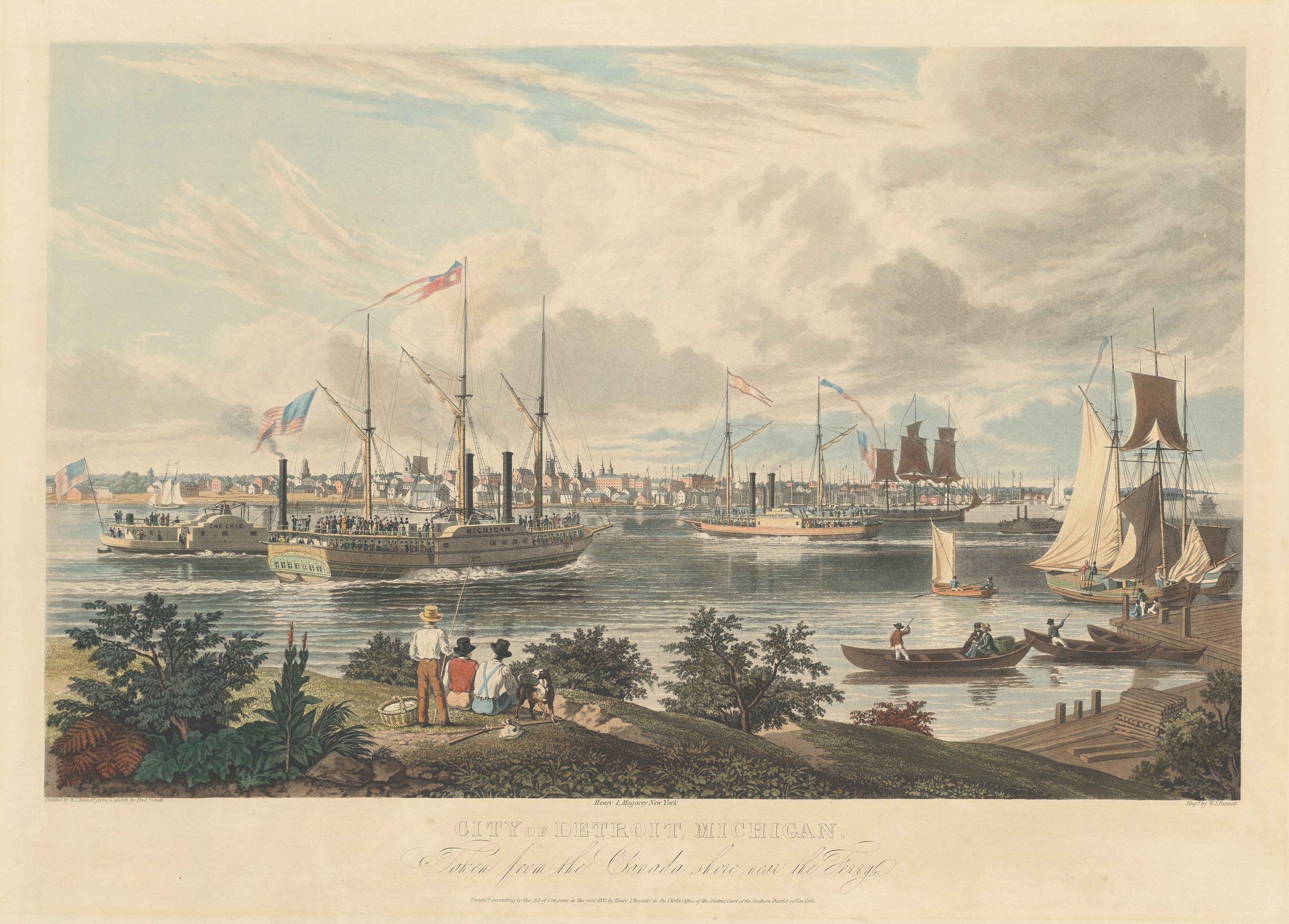
View of Detroit…1837
Here’s something really special for Clark House history lovers, a detailed drawing of the various kinds of sailing ships and steamboats as they passed by Detroit, Michigan on a sunny day in 1837, as seen from the Canadian side of the Detroit River. Take a close look; this is the view Peter Turck and his family—including daughter Mary, the future spouse of Jonathan M. Clark—would have seen as they traveled to Milwaukee in August of the same year1:
Bennett, William J., after a sketch by Frederick K. Grain, City of Detroit, Michigan. Taken from the Canada shore near the Ferry., hand-colored aquatint on engraving, ca. 1837. National Gallery of Art, Collection of Mr. and Mrs. Paul Mellon. Public Domain. Click to open larger image in new window.
UPDATED, February 11, 2024, to include a revised version of the annotated detail map of Ouisconsin, 1836. But for the full update—with additional notes and corrections—please see the most recent version of our discussion the Ouisconsin map of 1836 on our post of February 12, 2024. UPDATED, July 6, 2021, to answer a reader’s question: “Where was Jonathan Clark just before he went to Fort Howard?” Scroll down to Comments for the answer.
How the early settlers came to Mequon, c. 1835-1850 (part 1)
Clark House education director Margaret Bussone and our education team are putting together a project centered on how our Mequon pioneers traveled to southeast Wisconsin in the early days of white settlement, between roughly 1835 and 1850. I thought I’d help out by gathering some relevant materials and sharing them with the education team—and you—here on the blog.1
So this week we’re going to look at how the settlers found their way here, and how they traveled on land, lake, or river. Rather than writing lots of words about each map or image, I’d like to gather a whole bunch of useful items in each post and put them out there as resources for all to use. Later in the week, we’ll look at various modes of travel on land and on water. Today we’ll look at some maps.2 Some of these maps were readily available to our would-be immigrants, others might have been one-of-a-kind or otherwise hard to obtain.
An overview, The U.S. in 1834
When the following map was published in 1834, Jonathan M. Clark was finishing the first year of his three-year enlistment in the U.S. army. He was stationed at Ft. Howard, on the Green Bay of Lake Michigan, in what was then the civil District of Huron, a soon-to-be-outdated term for the western portion of the Michigan Territory.3
Mequon’s earliest settlers would be coming to lands that were poorly mapped and little understood by most European-Americans. The most this map could show—in a very general way—is where the “open” areas were for future migration and settlement.
Norris, William, and Daniel K Minor. Map of the railroads and canals, finished, unfinished, and in contemplation, in the United States. New York: Railroad Journal, 1834. Map. Library of Congress. Click to open larger map in new window.
As we learned in our previous post, Henry Clark—only son of Jonathan M. and Mary (Turck) Clark—was buried “in Cedarburg” on Monday, April 23, 1866. But if you seek Henry’s final resting place, you’ll find him next to his father, mother, and sister Josie in the Clark family lot at historic Forest Home Cemetery in Milwaukee. How this came to be, and what this tells us about Clark family history, is the subject of today’s post.
Clark family graves, lot 3, block 44, section 10, Forest Home Cemetery, Milwaukee, Wisconsin. Photo courtesy Liz Hickman, 2016. Click to open new image in larger window.
Heritage Days, a Clark House summer favorite, returns on Saturday, July 17, 2021, from 12:00 noon to 3:00 pm. No admission charge, but donations gladly accepted. Come enjoy some 1848-style family fun!
It was an eventful weekend. Congress—acting with a speed and unanimity1 unusual these days—declared a new federal holiday to celebrate June 19th as Juneteenth National Independence Day, formerly known and variously celebrated as Juneteenth, Emancipation Day, or Black Independence Day. It has roots in the issues and events of the Civil War years that I’m currently blogging about, and I’ll have more to share about the history of our newest federal holiday in a future post.
Sunday June 20 heralded the arrival of summer, and the observance of Fathers’ Day. In honor of both, I took the day off from writing and spent some time with my family. Wishing you all the best for summer, 2021, here’s an evocative seasonal print from Jonathan and Mary Clark’s era…
It’s been an awfully dry spring in southeastern Wisconsin. Even so, the grass around the Historian’s house has gotten pretty tall and scruffy. Time to get out the mower and tidy up the yard.