UPDATED, Oct. 4, 2021, with a few minor edits and to add an additional footnote.
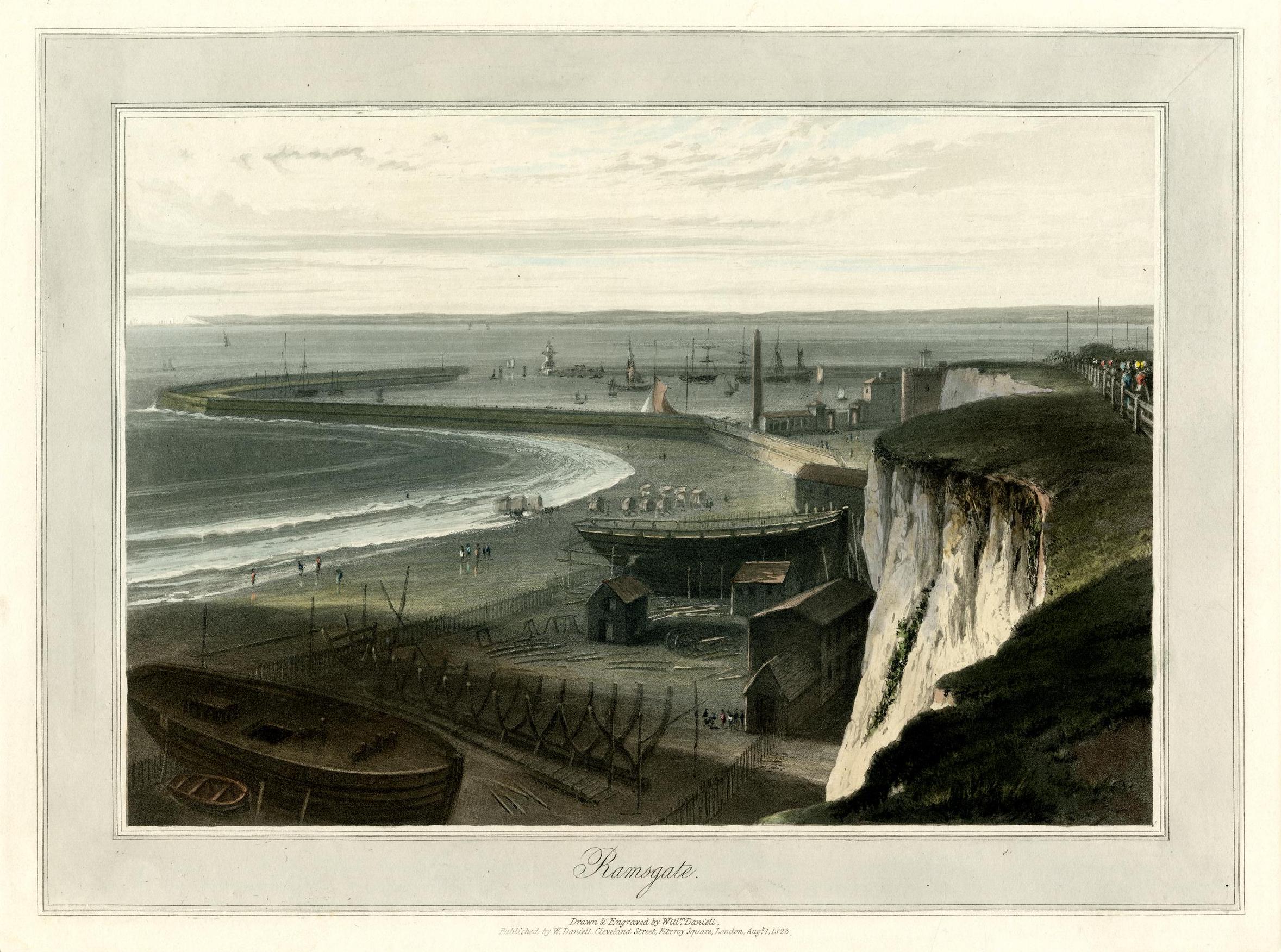
I’m still working on some longer posts; they should be ready soon. Meanwhile, I thought you might enjoy two lovely images, beginning with this nineteenth-century print, a view that would have been very familiar to a surprising number of our early Mequon immigrants:
This week our attention has been turned to New Orleans, the adopted home of Peter Turck’s eldest son—and Mary (Turck) Clark’s younger brother—Joseph R. Turck. Our previous post, J. R. Turck – from Mequon to New Orleans, sketched a brief outline of Joseph’s life, including a half century lived in the Crescent City. That post also discussed Joseph’s very brief service in a Confederate “home guard” militia unit during the Civil War, and how he had lost touch with his Wisconsin family during and after the capture of New Orleans in 1862.
A rare Peter Turck manuscript
We have a number of examples of Peter Turck’s signature—and an occasional bit of text in his hand—from various land documents, marriage licenses, federal census pages, citizen petitions, and other documents from the 1840s to the 1860s. Today’s document is the only letter I have seen in Peter Turck’s own hand, and it gives us a rare insight into Peter Turck’s paternal feelings (as expressed in the typically florid and deferential language of the era) and some additional details about the life of his eldest son, Joseph.1 It’s an interesting letter, and I thought you might like to read it.
Turck’s letter is preserved as part of National Archives and Record Administration (NARA) publication M345, Papers Relating to Citizens, compiled 1861 – 1867. These are letters sent by U.S. civilians to the Provost Marshal’s office of the Union Army. The Provost Marshal was, essentially, the chief of the military police in an area occupied by Union troops.
This letter was published in NARA series M345, microfilm roll 0270, item Joseph R. Turck. It’s accessible online at Fold3.com (pay site). The transcription is mine, and preserves Peter Turck’s occasional curious spelling or punctuation errors. The original letter appears to cover two sides of a single sheet of paper. The original envelope was not microfilmed; it was probably discarded by the New Orlean’s provost marshal’s staff in 1862.
Milwaukee, July 25th 1862
Turck, Peter to Gen. Benjamin F. Butler, July 25, 1862, page 1 of 2. NARA publication M345 Papers Relating to Citizens, compiled 1861 – 1867. Roll 0270, Joseph R. Turck, Fold3.com, accessed 20 March 2014. Click to open larger image in new window.
Previously, we turned our thoughts to the historic city of New Orleans, and the disastrous impact of then-ongoing Hurricane Ida. Once again the Crescent City was hit by a major hurricane. Ida has since moved on and lessened in intensity, but leaves in its wake significant wind and water damage; over one million Louisiana residents are currently without electricity, gasoline, and fresh water, and it looks like it will take weeks to restore services. We wish a speedy recovery for all those in the affected areas.
I have a more-than-passing interest in New Orleans because our Clark House family has ties to the city; Mary (Turck) Clark’s brother, Joseph Robert Turck (1823-1902), spent most of his adult life there.
New Orleans, Louisiana Sugar and Rice Exchange, c. 1891. Source and credits, below (note 1). Click to open larger image in new window.
Joseph R. Turck
Like his big sister Mary, Joseph R. Turck was born in Athens, Greene county, New York. He was about five years old when the family moved to Wayne county, New York, and about fourteen years old when the family migrated west to Mequon in 1837.
In February, 1845, Joseph purchased 40 acres of his father Peter Turck’s Mequon land.2 Joseph did not keep it long; he sold it back to his father in September of the same year. What happened next? We’re not sure. But by 1848 Joseph had left Wisconsin and relocated to New Orleans.
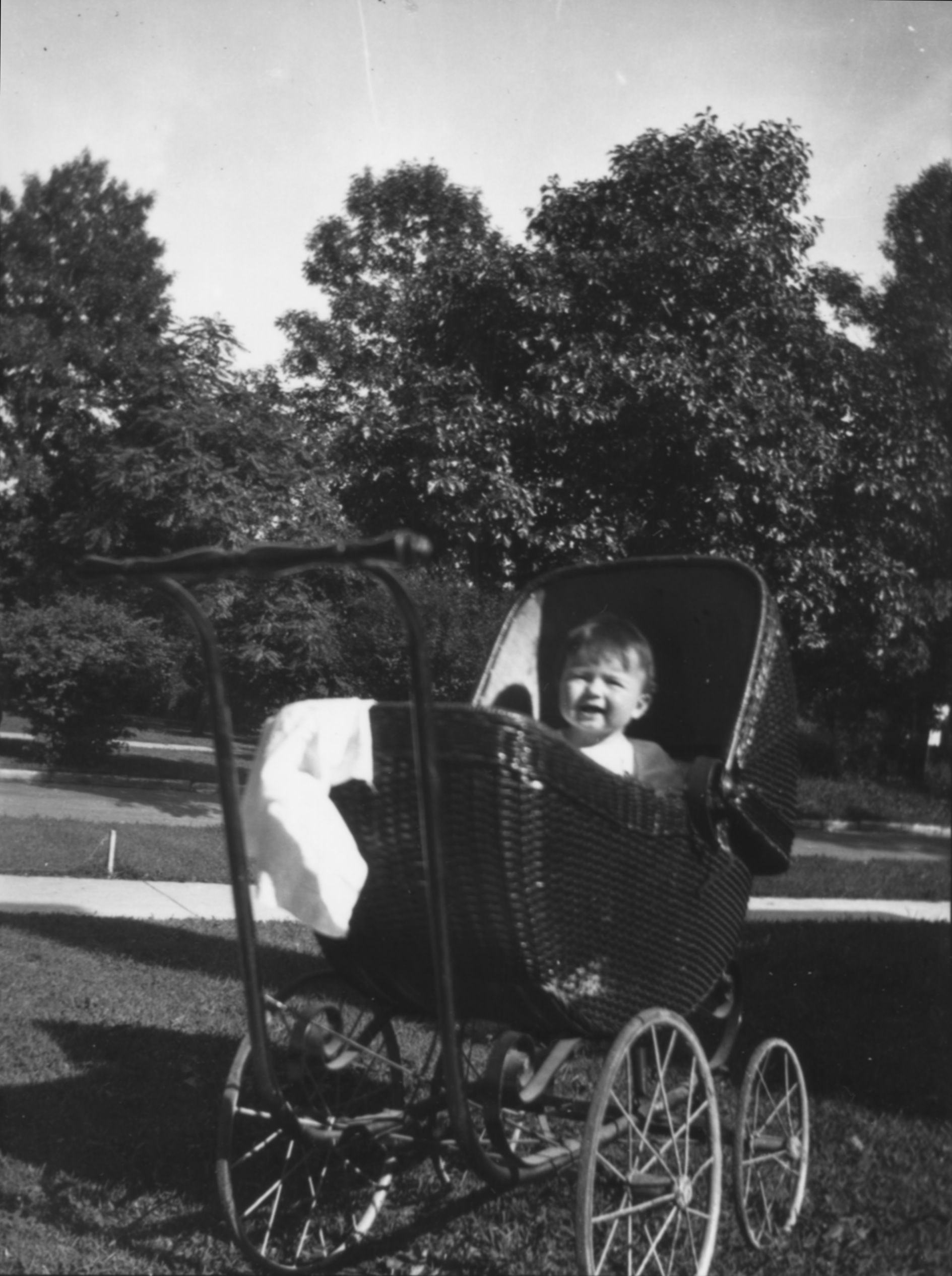
I don’t usually post on Saturdays, but today is a special day. It’s the 100th anniversary of my Dad’s birth, and I thought it deserved at least a short CHH mention.
John H. Perkins, 1921 – 2004
My dad lived a long and eventful life, too much to cover in a single blog post. But since our recent Clark House Historian posts have been focused on historic boats and other Clark-era modes of transportation, I thought I’d share a few choice photos of Dad on the go—on water and on land—with a few biographical remarks to set the scene.
Here’s an early example:
John H. Perkins in baby carriage, probably Evanston, Illinois, circa Spring or Summer, 1922. Perkins family collection. Click to open larger image in new window.
Our series of “How’d they get here?” posts is written to illustrate the nuts and bolts of how our early Mequon pioneers travelled from their original homes or ports of arrival in North America to the newly opened federal lands in Wisconsin Territory, circa 1830-1850. Today’s post continues our westward journey from Buffalo; see Note 1 (below) for links to earlier posts in the series.
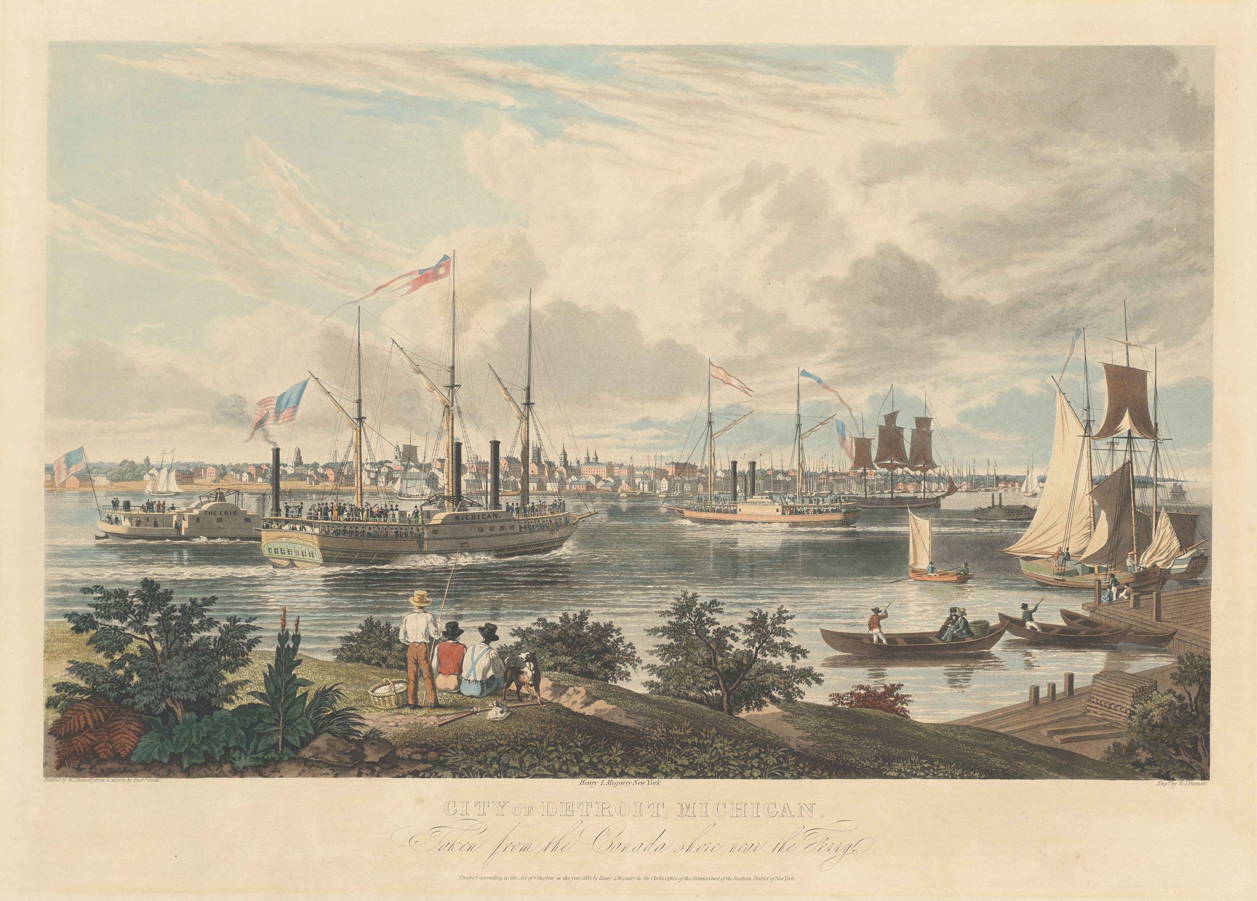
The ships at Detroit, 1837
We closed our previous post with a brief look at a colorful aquatint of the ships and small craft on the Detroit River, a major port on the Great Lakes route between Buffalo and Chicago in the 1830s and ’40s. The print was published in 1837, and is an excellent illustration of almost all of the important types of ships in use during the years of Wisconsin Territory settlement:
Bennett, William J., after a sketch by Frederick K. Grain, City of Detroit, Michigan. Taken from the Canada shore near the Ferry., hand-colored aquatint on engraving, ca. 1837. National Gallery of Art, Collection of Mr. and Mrs. Paul Mellon. Public Domain. Click to open larger image in new window.
If you’re not clear on your Michigan and Upper Canada (now Ontario) geography, the artist was standing on the Canadian shore, looking west across the river to the city of Detroit. The two steamboats at the left center of the picture are headed north, upstream on the Detroit River that connects Lake Erie to Lake St. Clair and, via the St. Clair River, to Lakes Huron, Michigan and Superior.
Given that the picture shows leafy green foliage and men in shirt-sleeves, it was probably drawn in the spring or summer of 1837 (or a perhaps a year or two earlier?). In August, 1837, the Peter Turck family—including eldest daughter Mary Turck—migrated from Wayne county, New York, to Milwaukee via this exact route and, perhaps, on one of the ships shown in this picture. Other Mequon immigrants, including the Bigelow, Bonniwell, Loomer, Strickland and Woodworth families (and many others), would have seen similar views as they travelled from the eastern seaboard to Wisconsin Territory in the ’30s and ’40s.
There is a lot to see here. Let’s take a closer look…
Our series of “How’d they get here?” posts is written to illustrate the nuts and bolts of how our early Mequon pioneers travelled from their original homes or ports of arrival in North America to the newly opened federal lands in Wisconsin Territory, circa 1830-1850. Today’s post continues our westward journey from Buffalo; see Note 1 (below) for links to other posts in the series.
On to the West!
After traveling the Erie Canal and leaving Buffalo harbor, our westward emigrants would sail the length of Lake Erie, on their way to Lakes St. Clair, Huron, and Michigan and—eventually—landfall in the Wisconsin Territory.
Regular steamboat service between Buffalo and Detroit was available at least as early as 1825.2 The 330-mile route included scheduled stops in Erie, Pennsylvania, the mouth of the Grand River (at Fairport, Ohio), and the Ohio ports of Cleveland and Sandusky, before finally arriving at the city of Detroit. By the mid-1830s the number of stops had increased to serve other developing port towns along Lake Erie’s southern shore and points further on, including Green Bay, Milwaukee, and Chicago.
The Cleveland light, circa 1834
Day or night, fair weather or foul, our westbound Mequon settlers would have noticed a variety of sights along the way, including a handful of navigation lights constructed by the federal government. One of the most notable was the harbor light at Cleveland, Ohio.
Bodmer, Karl. “Leuchtthurm bei Cleveland am Erie See. Phare de Clevelandsur le Lac Erie. Cleveland Lighthouse on the Lake Erie.” The New York Public Library Digital Collections. Published 1840 – 1843, original drawing c. 1834. Click to open larger image in new window.
Our series of “How’d they get here?” posts is written to illustrate the nuts and bolts of how our early Mequon pioneers travelled from their original homes or ports of arrival in North America, to the newly opened federal lands in Wisconsin Territory, circa 1830-1850. See Note 1, below, for links to other posts in the series.
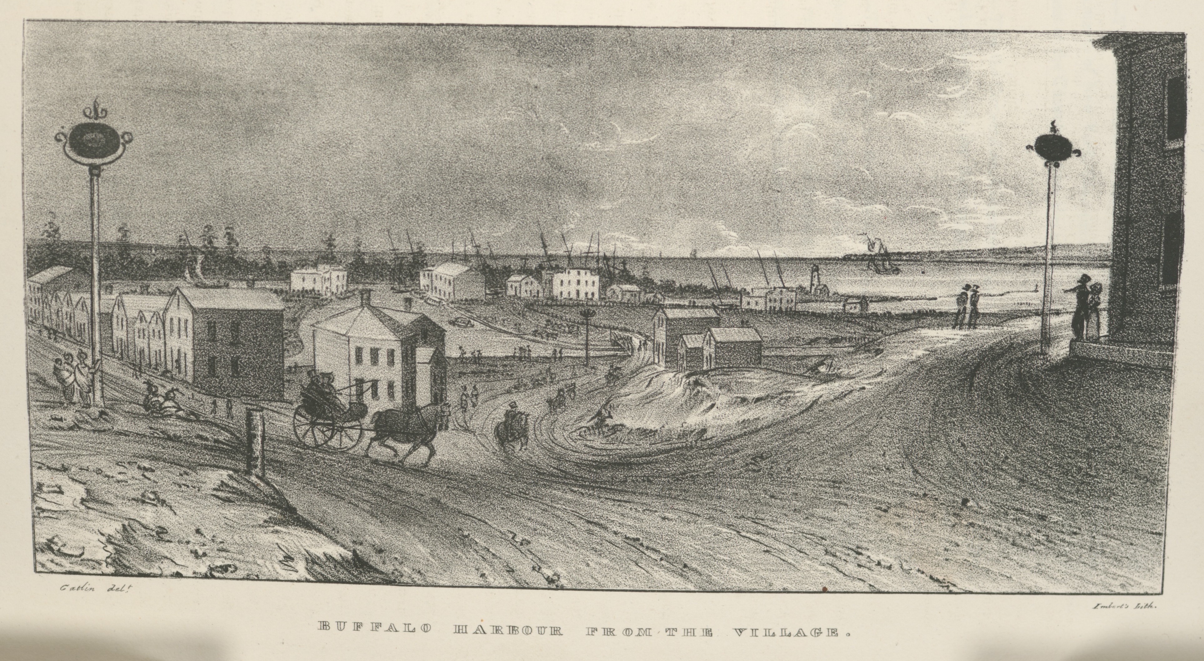
Village of Buffalo, 1825
In a previous post, we followed the newly-opened route for westward migrants from the New York City docks, up the Hudson River to Albany, and then along the new Erie Canal towards its terminus at the village of of Buffalo, New York, at the eastern end of Lake Erie. After seven days of travel on canal boats, the westbound traveler of 1825 would have looked up and seen this, the muddy streets and modest harbor of Buffalo:
Buffalo Harbour from the Village, in Cadwallader Colden, et. al., Memoir…at the Completion of the New York Canals, New York, 1825. Image from “extra-illustrated” edition in New York Public Library Digital Collections, scanned copy of standard edition of book via GoogleBooks. Public domain. Click to open larger image in new window.
After leaving the Deep Cut above Lockport, the last part of the Erie Canal merges with Tonawanda Creek, seen here flowing into the village from far left to center, in front of the line of distant trees, and then curving toward the viewer before exiting into the harbor, to the right. The original Buffalo lighthouse of 1818 can be see on a small peninsula, right of center, just above where Tonawanda Creek meets the lake.
Earlier this summer, while putting together the post How’d they get here? – early Erie Canal images, I came across a tidily-drawn print that helps illustrate the story of the Peter and Rachael (Gay) Turck family’s life before coming to Mequon. It’s downtown Palmyra, Wayne county, New York, in 1825:
Unknown artist, Eastern view in Main-street, Palmyra., in Cadwallader Colden, et. al., Memoir…at the Completion of the New York Canals, New York, 1825. Image from “extra-illustrated” edition in New York Public Library Digital Collections, scanned copy of standard edition of book available via GoogleBooks. Click to open larger image in new window.
One of the really neat aspects of researching and writing about Clark House history on this site is the feedback I receive from blog readers. I love hearing from you, whether you have a comment or a question about the topic at hand, or perhaps there is something else that you want to know more about.
[Occupational Portrait of a Salesman], Three-Quarter Length, Seated, Displaying His Wares. Daguerreotype, between 1850 and 1860, cropped and lightly color-adjusted. Library of Congress. Click to open larger image in new window.
“UPDATED…”
History is never “done.” No one can know it all. There are always new sources with fresh information, and new ways to look at well-known material. A question or a new bit of information from a reader will often prompt additional research or a correction to previous statements. The result is that this blog—and our knowledge of the Clark family, their neighbors, and their era—is constantly evolving.
UPDATED August 12, 2021 (twice), with more information on Orange Dibble’s derrick, illustrated below. See my reply to the question from reader Chester T. Hartwell in Comments, below.
UPDATED July 29, 2021, to include some new general information and details about several of the images sent by reader Robert Randall, second vice-president of the Camillus Canal Society. For Mr. Randall’s full message, see Comments, below. For more on the society’s Camillus Erie Canal Park, click here.
How the early settlers came to Mequon, c. 1835-1850 (part 3)
Our series of “How’d they get here?” posts is written—in part—to help our education team put together a Clark House Museum educational activity. The idea is to illustrate the nuts and bolts of how our early Mequon pioneers travelled from their original homes or ports of arrival in North America, to the newly opened federal lands in Wisconsin Territory, circa 1835-1850. (If you missed ’em, the previous parts are here and here, with a bonus image, here.)
Erie Canal images – 1825!
Finally!! For years, I’ve been searching for images of the unique, low-draft, narrow-sided, low-height, lock-length boats designed for and used in the earliest years of the Erie and Champlain canals (c. 1825-1840). And year after year, I had no luck finding such images…until this week.
You might be thinking, “hasn’t Clark House Historian already spent quite a bit of time on the Erie Canal?,” and you’d be correct. But it’s hard to overstate the national and international importance of the Erie Canal on world trade and American westward expansion in the decades after its opening in 1825. And while we have used maps to illustrate the migration routes of some Mequon settlers (such as the Turck, Gay, Bonniwell, and Woodworthfamilies), I wasn’t able to adequately illustrate the details of how they travelled in the early days of the canal era. Until now.
Today’s treasure trove of early canal images is from Cadwalleder Colden, et. al., Memoir…at the Completion of the New York Canals, New York, 1825. Many of these images are from the “extra-illustrated” edition in New York Public Library Digital Collections; you can download and enjoy a scanned copy of the standard edition of the book via GoogleBooks. Yes, these images are a bit early for our generally 1835-1850 “How’d they get there?” timeframe. But these are, by far, the best visual representations of early New York canal travel that I have seen. Even though Jonathan M. Clark, and the Woodworth and Bonniwell families and other Mequon settlers did not travel on the canals until the 1830s, these images depict scenes they would have experienced along the Champlain and Erie canals.
Please take a close look at each image for the “big picture,” then click on each and zoom in on the details. All the images can be clicked on to open as a larger, downloadable, image in a new window. All images are believed to be in the public domain, and I encourage you to enjoy, download, save, share and use them as you see fit.
Canal Boats
Here is an excellent view of a group of the new canal boats, loading freight and soliciting business at the North [i.e., Hudson] River docks, New York City, before heading up the Hudson to Albany and the canals:
Canal boats on the north river, New York, in Cadwallader Colden, et. al., Memoir…at the Completion of the New York Canals, New York, 1825. Image from “extra-illustrated” edition in New York Public Library Digital Collections, scanned copy of standard edition of book via GoogleBooks.