Our series of “How’d they get here?” posts is written to illustrate the nuts and bolts of how our early Mequon pioneers travelled from their original homes or ports of arrival in North America, to the newly opened federal lands in Wisconsin Territory, circa 1830-1850. See Note 1, below, for links to other posts in the series.
Village of Buffalo, 1825
In a previous post, we followed the newly-opened route for westward migrants from the New York City docks, up the Hudson River to Albany, and then along the new Erie Canal towards its terminus at the village of of Buffalo, New York, at the eastern end of Lake Erie. After seven days of travel on canal boats, the westbound traveler of 1825 would have looked up and seen this, the muddy streets and modest harbor of Buffalo:
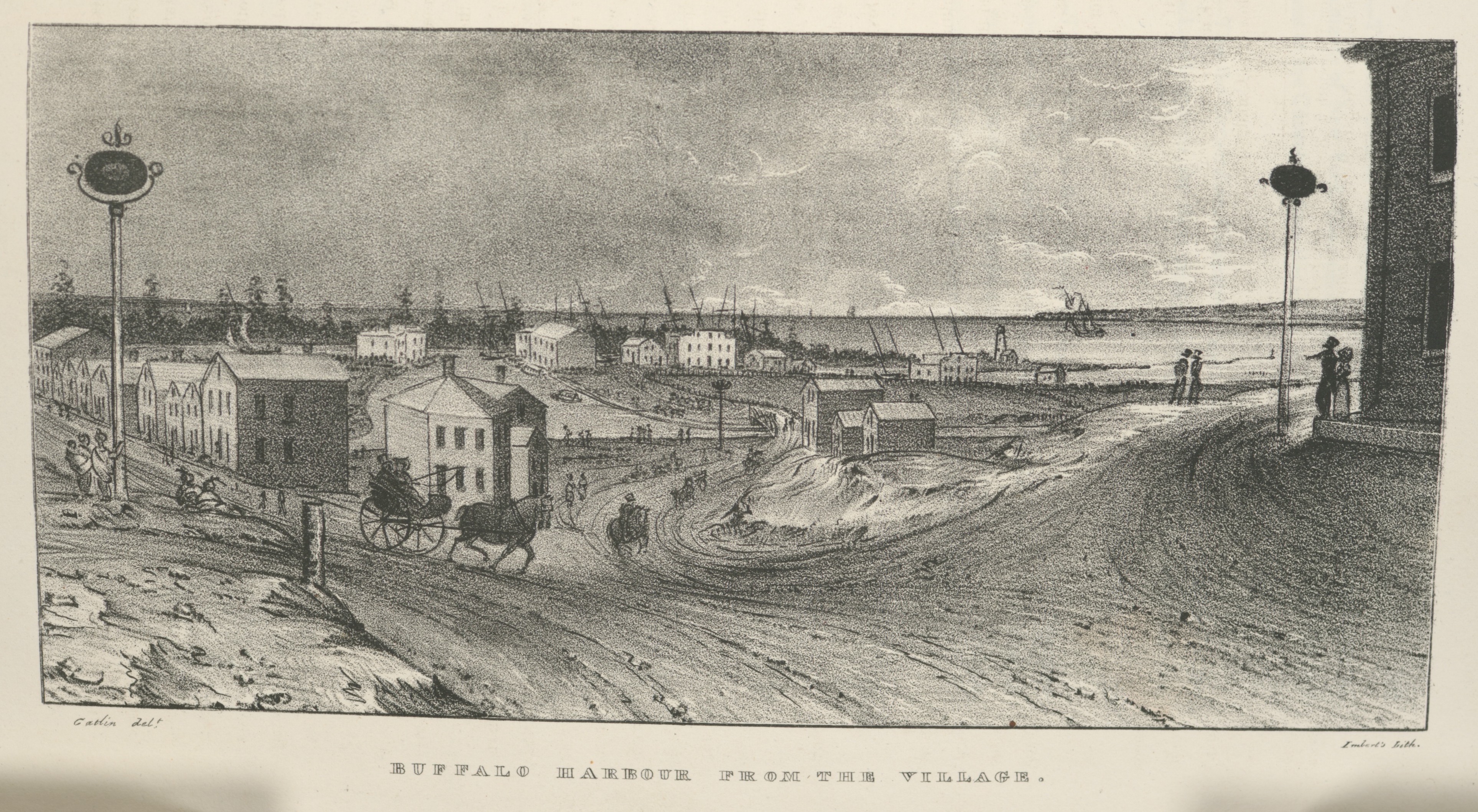
Buffalo Harbour from the Village, in Cadwallader Colden, et. al., Memoir…at the Completion of the New York Canals, New York, 1825. Image from “extra-illustrated” edition in New York Public Library Digital Collections, scanned copy of standard edition of book via GoogleBooks. Public domain. Click to open larger image in new window.
After leaving the Deep Cut above Lockport, the last part of the Erie Canal merges with Tonawanda Creek, seen here flowing into the village from far left to center, in front of the line of distant trees, and then curving toward the viewer before exiting into the harbor, to the right. The original Buffalo lighthouse of 1818 can be see on a small peninsula, right of center, just above where Tonawanda Creek meets the lake.
Another view
Below is a complementary view from the same 1825 source. It was made across the creek, standing near the old lighthouse, looking back in the general direction of the first image, and showing some of the ships in the not-particularly-busy Buffalo harbor.2

Buffalo from the Light House, in Cadwallader Colden, et. al., Memoir…at the Completion of the New York Canals, New York, 1825. Image from “extra-illustrated” edition in New York Public Library Digital Collections, scanned copy of standard edition of book via GoogleBooks. Public domain. Click to open larger image in new window.
Across the water to the right, in front of what look like several large warehouses, six large, double-masted schooners lie at anchor with sails furled. Just left of center is a two-masted, side paddlewheel steamer, the Superior. Sailing along the the left side of the print is a single-masted gaff-rigged sloop with its mainsail and foresail raised.3 The shoreline in the foreground, bare and undeveloped, provides a place for local folk to stroll and watch the ships.
Government spending and economic development
New York’s great canal project began construction in 1817. The Champlain Canal was completed in 1823; the first version of the Erie Canal was finished in 1825. Both were on time and under budget. The project cost $7,143,789 to build—an enormous sum at the time—and paid for itself in only ten years.4
The canal helped cement New York City’s role as the transportation and economic hub of the United States, and led to the development of agriculture, manufacturing, and numerous towns and cities in upstate New York and beyond. The canal system quickly became a pivotal part of the rapid migration of tens of thousands of settlers bound for the newer U.S. states and territories west of the Appalachian mountains.
City of Buffalo, 1836
What a difference a successful canal makes! Until the late-1820s, Buffalo was a modest, rural village on the shores of Lake Erie:
As a remote outpost, village residents hoped that the proposed Erie Canal would bring prosperity to the area. To accomplish this, Buffalo’s harbor was expanded with the help of Samuel Wilkeson; it was selected as the canal’s terminus over the rival Black Rock. It opened in 1825, ushering in commerce, manufacturing and hydropower. By the following year, the 130-square-mile Buffalo Creek Reservation (at the western border of the village) was transferred to Buffalo. Buffalo was incorporated as a city in 1832. During the 1830s, businessman Benjamin Rathbun significantly expanded its business district. The city doubled in size from 1845 to 1855.
The beautiful aquatint of Buffalo harbor (below) was published in 1836, only eleven years after our first two engravings. The volume and variety of ships, freight, and passengers in the Buffalo harbor has increased significantly since 1825 and the harbor has been expanded and improved. The pier at the mouth of the harbor was extended and a new, taller, octagonal lighthouse had been added in 1833.5
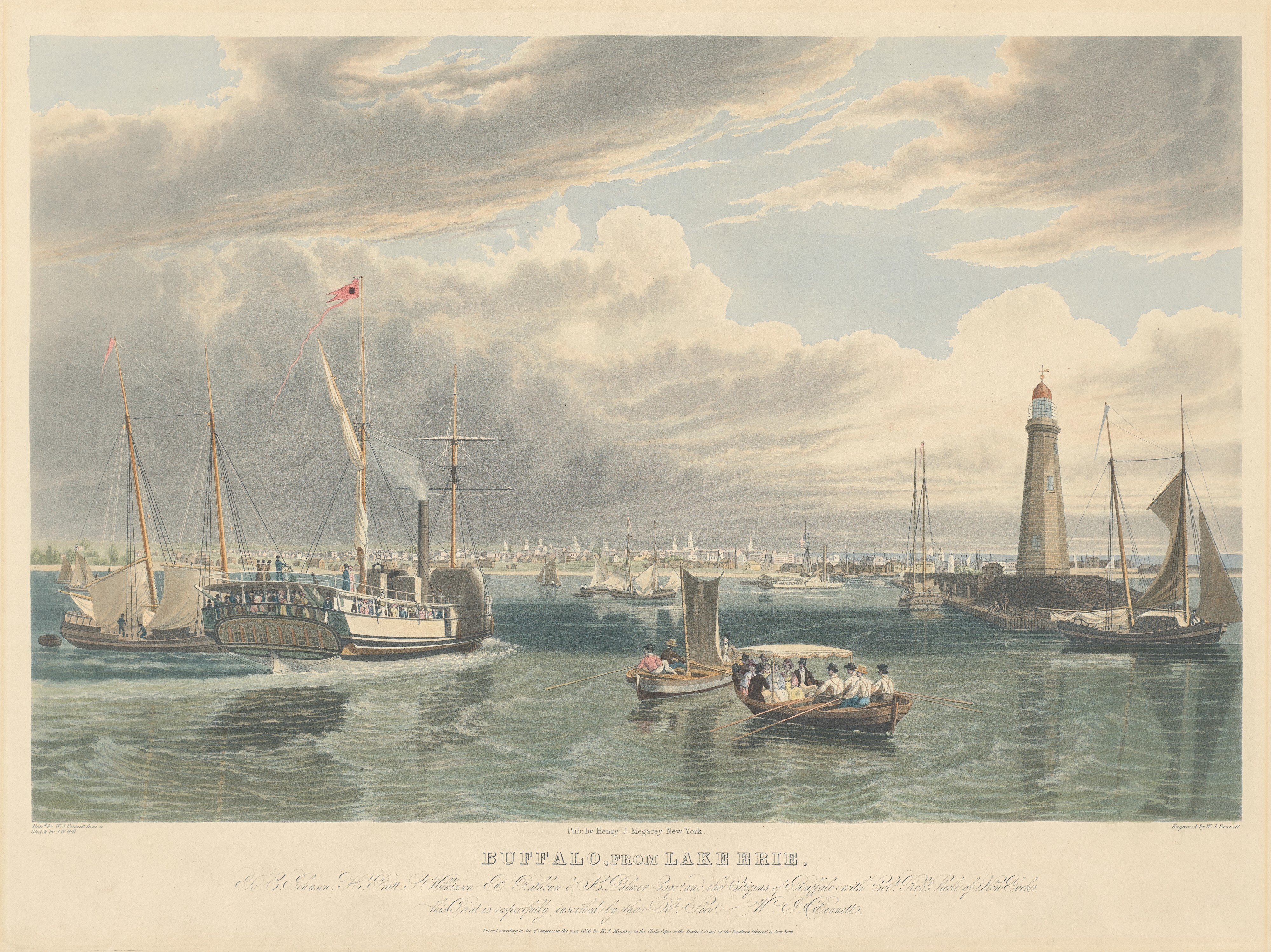
Bennet, William J. and John W. Hill, Buffalo, from Lake Erie, 1836. Hand-colored aquatint with touches of engraving on paper, National Gallery of Art, Collection of Mr. and Mrs. Paul Mellon. Public domain. Click to open larger image in new window.
Just one year after this image was published, in September, 1837, the Peter Turck family—including sixteen-year-old daughter Mary, the future spouse of Jonathan M. Clark—would leave their home in Macedon, New York, travel the Erie Canal to Buffalo, and book passage to Wisconsin on one of the Buffalo steamers. This is very likely how Buffalo harbor would have looked like to them—and to the other Mequon immigrants of the era—as they departed the settled East for the wilds of Wisconsin Territory:
Ships in a busy harbor
This 1836 image gives us a good look at many of the kinds of ships active on the Great Lakes in the 1830s and beyond. There are ships of all sizes, ready for transporting passengers and freight to other quickly-expanding port towns and cities such as Erie, Cleveland, Detroit, Mackinac, Green Bay, Milwaukee and Chicago. Other smaller craft serve as lighters and water taxis, delivering freight or passengers to and from the larger ships.
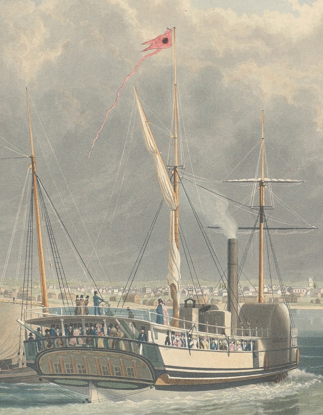
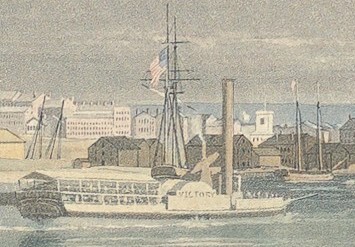


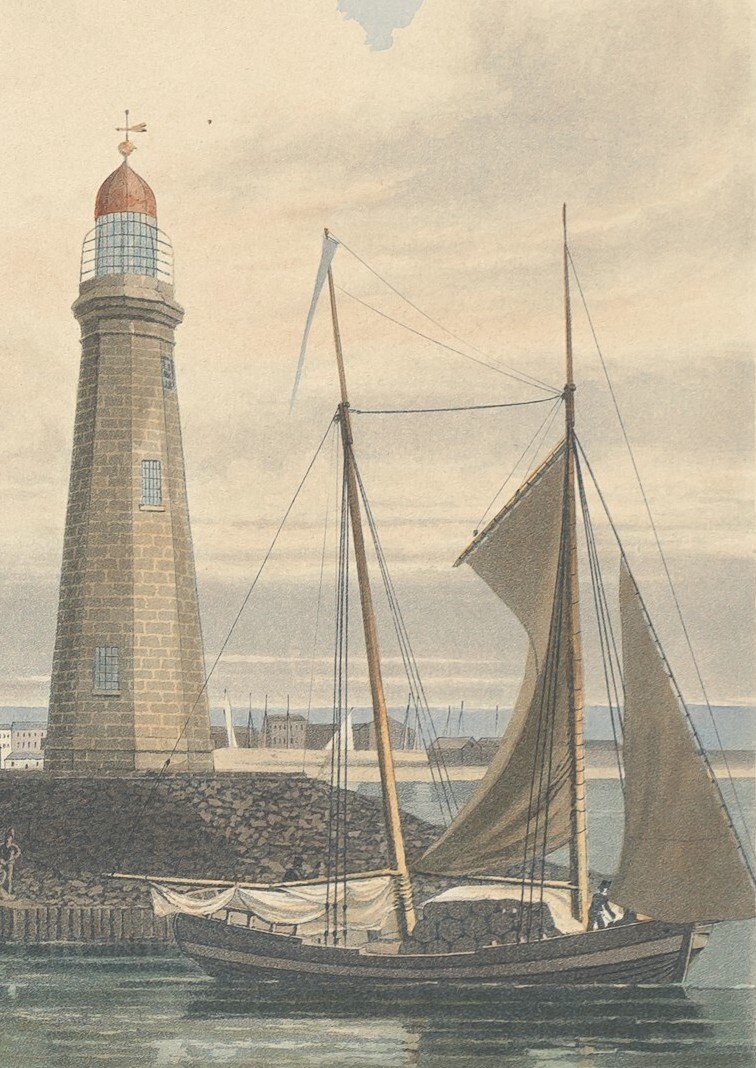
Gallery of details from Bennet, William J. and John W. Hill, Buffalo, from Lake Erie, 1836. Hand-colored aquatint with touches of engraving on paper, National Gallery of Art, Collection of Mr. and Mrs. Paul Mellon. Public domain. Click to open larger images in slideshow. Click “Information” below the slideshow images to open larger copy in new window. See slideshow captions for image descriptions.
I hope you will spend some time clicking on the images and zooming in for more details. Today’s large engravings and aquatint are filled with information, and are the closest we have to snapshots of the sights seen and ships sailed on by so many of our Mequon settlers, including the Bigelow, Bonniwell, Loomer, Strickland and Woodworth families. And these are the same views seen by soldiers traveling to posts on the Great Lakes, including Pvt. Jonathan M. Clark, traveling to join the 5th Infantry at Ft. Howard in September, 1833.
Coming up: more beautiful and informative images and tales of 1830s and ’40s travel to Wisconsin via Lake Erie, Cleveland, Detroit, and other stops. We’ll also spend some time on the various small boats found on the Lakes and inland waterways: canoes, batteaux, Mackinaw boats, dories, flatboats, and more.
See you next time.
___________________________________________
NOTES:
- If you missed ’em, the previous parts of this series are:
• Monday: Map Day! – How’d they get here?
• How’d they get here? – Steamboats!
• How’d they get here? – early Erie Canal images
• and bonus ship images and information at, Steamboat’s coming!, Heavy weather…, Steaming against the wind… and Still steaming ahead…
Also, there are other really useful Erie Canal-related posts on the blog, written before the current “How’d they get here?” series. You can find them all by typing “Erie Canal” in the blog’s Search box. You’ll get at least 10 results.
If you only have time to read one of these, I recommend reading Monday: Map Day! – The Erie Canal, from February 15, 2021. That post is focused on how Jonathan M. Clark, Mary (Turck) Clark, and the Turck and Gay families migrated in stages from their homes in the northeast to their new homes in upstate New York and then on to Wisconsin in the 1820s and ’30s. This February post also includes a really informative, downloadable, high-resolution map of New York state and the canal system, circa 1834 (2 versions: original and with my annotations), plus the dates of quite a few family birthdays and links to many other relevant Clark House Historian posts. - To be fair, the Erie Canal did not officially open until October 26, 1825. If these first two images of Buffaloo were made as part of the official opening journey and celebration (and I believe they were), then it’s likely that Great Lakes shipping, modest as it was in pre-canal days, was wrapping for the year and preparing for the close of shipping until next spring. So these two pictures may not be completely representative of Buffalo harbor traffic circa 1825 and earlier.
- Avast, ye scurvy dogs! For the record, I am not a sailor. I did my reading and I’ve tried to describe and label each type of sail- and steam-ship with the proper terms. But I will not be surprised if I’ve made a howler or two. So please feel free to send any corrections or suggestions to me via the public Leave a Reply on this post, or the private Contact function. And if you want to dig into the whole ship terminology whirlpool, the Wikipedia entry, “Sail Plan” is a good place to start.
- Statistics from the National Park Service’s Erie Canalway Corridor pages.
- More on the 1833 Buffalo Main Light at Wikipedia

Pingback: How’d they get here? – Westward on Lake Erie to Detroit | Clark House Historian
Pingback: How’d they get here? – Great Lakes ships, circa 1837 | Clark House Historian