Our series of “How’d they get here?” posts is written to illustrate the nuts and bolts of how our early Mequon pioneers travelled from their original homes or ports of arrival in North America to the newly opened federal lands in Wisconsin Territory, circa 1830-1850. Today’s post continues our westward journey from Buffalo; see Note 1 (below) for links to other posts in the series.
On to the West!
After traveling the Erie Canal and leaving Buffalo harbor, our westward emigrants would sail the length of Lake Erie, on their way to Lakes St. Clair, Huron, and Michigan and—eventually—landfall in the Wisconsin Territory.
Regular steamboat service between Buffalo and Detroit was available at least as early as 1825.2 The 330-mile route included scheduled stops in Erie, Pennsylvania, the mouth of the Grand River (at Fairport, Ohio), and the Ohio ports of Cleveland and Sandusky, before finally arriving at the city of Detroit. By the mid-1830s the number of stops had increased to serve other developing port towns along Lake Erie’s southern shore and points further on, including Green Bay, Milwaukee, and Chicago.
The Cleveland light, circa 1834
Day or night, fair weather or foul, our westbound Mequon settlers would have noticed a variety of sights along the way, including a handful of navigation lights constructed by the federal government. One of the most notable was the harbor light at Cleveland, Ohio.
Bodmer, Karl. “Leuchtthurm bei Cleveland am Erie See. Phare de Clevelandsur le Lac Erie. Cleveland Lighthouse on the Lake Erie.” The New York Public Library Digital Collections. Published 1840 – 1843, original drawing c. 1834. Click to open larger image in new window.
Our series of “How’d they get here?” posts is written to illustrate the nuts and bolts of how our early Mequon pioneers travelled from their original homes or ports of arrival in North America, to the newly opened federal lands in Wisconsin Territory, circa 1830-1850. See Note 1, below, for links to other posts in the series.
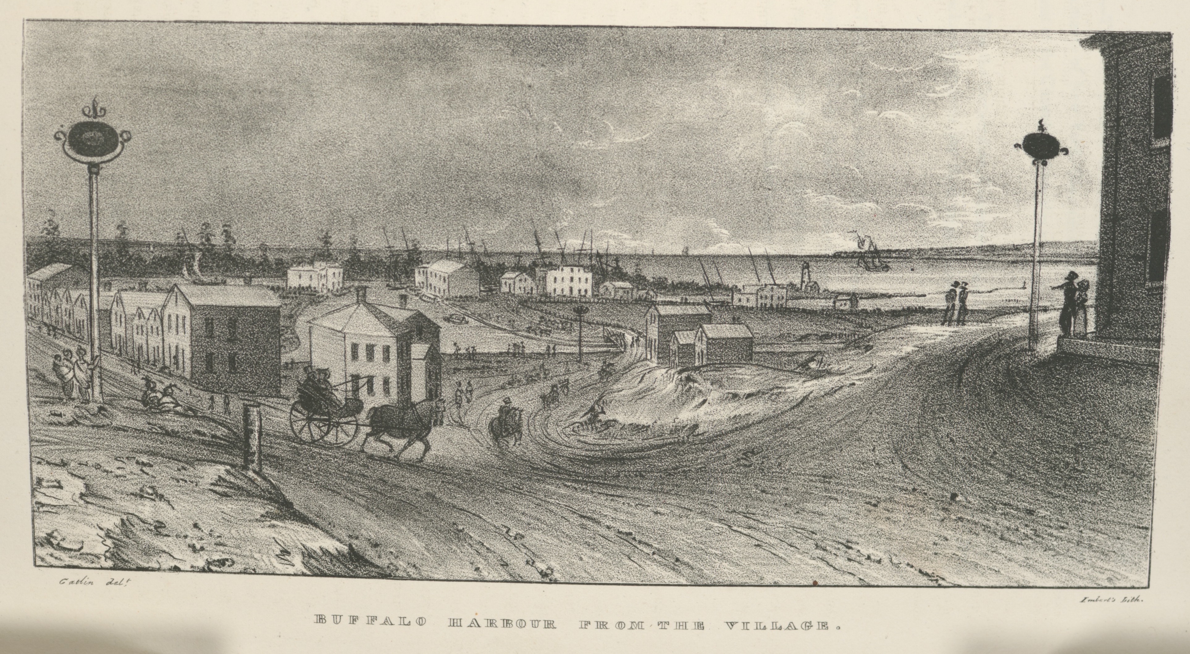
Village of Buffalo, 1825
In a previous post, we followed the newly-opened route for westward migrants from the New York City docks, up the Hudson River to Albany, and then along the new Erie Canal towards its terminus at the village of of Buffalo, New York, at the eastern end of Lake Erie. After seven days of travel on canal boats, the westbound traveler of 1825 would have looked up and seen this, the muddy streets and modest harbor of Buffalo:
Buffalo Harbour from the Village, in Cadwallader Colden, et. al., Memoir…at the Completion of the New York Canals, New York, 1825. Image from “extra-illustrated” edition in New York Public Library Digital Collections, scanned copy of standard edition of book via GoogleBooks. Public domain. Click to open larger image in new window.
After leaving the Deep Cut above Lockport, the last part of the Erie Canal merges with Tonawanda Creek, seen here flowing into the village from far left to center, in front of the line of distant trees, and then curving toward the viewer before exiting into the harbor, to the right. The original Buffalo lighthouse of 1818 can be see on a small peninsula, right of center, just above where Tonawanda Creek meets the lake.
Chambers, Thomas. Storm-Tossed Frigate, oil on canvas, mid 19th century (c. 1836-1845). National Gallery of Art, gift of Edgar William and Bernice Chrysler Garbisch. Public domain. Click to open larger image in new window.
This is another installment in the transportation-themed series that began with our July 6, 2021, Monday: Map Day! – How’d they get here? and continues from there.
Queen, James Fuller, [A Man and a Woman Standing at the Entrance to a Trail Through a Forest] (detail), graphite drawing on cream paper, circa 1850-1870. Library of Congress
I’m still writing the next two (or three) longer, narrative installments of our “How’d they get here?” series, which I began working on to assist Clark House education director Margaret Bussone and our education team as they develop a transportation-themed project for use at the Jonathan Clark House later this summer.
For quite a while I was worried that I would not be able to find enough visual material to adequately illustrate our early Mequon immigrants’ journeys of the 1830s and ’40s. It turns out that I now have a lot of material to share with the education team—and with you. Rather than hold on to it until my longer posts are complete, I thought I’d do something different today.
I’m still working on the next two (or three) more substantial installments of our “How’d they get here?” series, so here’s another “bonus” post, while you’re waiting. If you need to catch up, the series began with our July 6, 2021, Monday: Map Day! – How’d they get here? and continues from there.
Some weeks ago, when I began to research this topic, I was worried; I didn’t think that I would be able to find enough information and visual material to adequately illustrate our Mequon immigrants’ journeys of the 1830s and ’40s. It turns out that I now have (cough) a boatload of material to sort through and organize. So more of “How’d they get here?” is coming soon. Meanwhile, here’s another fine Great Lakes steamer from the time of our Mequon pioneers:
N. Currier. Buffalo & Chicago steam packet Empire State: M. Hazard, Commander. New York, circa 1835-1856 (probably 1848 or later, see below). Photograph of hand-colored lithograph. Library of Congress. Click to open larger image in a new window.
Ahoy, readers! Here’s another “bonus” post for our ongoing series “How’d they get here?” If you need to catch up, the series began with our July 6, 2021 post Monday: Map Day! – How’d they get here? and continues from there.
I’m working on the next two (or three) more substantial installments of the series, metaphorically steaming against the wind through virtual piles of documents, books, and historical images. It’s going well, but taking a bit longer than I hoped. So while you’re waiting, how about another beautiful Great Lakes ship image, this time courtesy of the National Gallery of Art in Washington:
[American artist, 19th century], Steamship Erie, probably 1837, oil on canvas, National Gallery of Art, Gift of Edgar William and Bernice Chrysler Garbisch. Public domain. Click to open larger image in new window.
UPDATED August 12, 2021 (twice), with more information on Orange Dibble’s derrick, illustrated below. See my reply to the question from reader Chester T. Hartwell in Comments, below.
UPDATED July 29, 2021, to include some new general information and details about several of the images sent by reader Robert Randall, second vice-president of the Camillus Canal Society. For Mr. Randall’s full message, see Comments, below. For more on the society’s Camillus Erie Canal Park, click here.
How the early settlers came to Mequon, c. 1835-1850 (part 3)
Our series of “How’d they get here?” posts is written—in part—to help our education team put together a Clark House Museum educational activity. The idea is to illustrate the nuts and bolts of how our early Mequon pioneers travelled from their original homes or ports of arrival in North America, to the newly opened federal lands in Wisconsin Territory, circa 1835-1850. (If you missed ’em, the previous parts are here and here, with a bonus image, here.)
Erie Canal images – 1825!
Finally!! For years, I’ve been searching for images of the unique, low-draft, narrow-sided, low-height, lock-length boats designed for and used in the earliest years of the Erie and Champlain canals (c. 1825-1840). And year after year, I had no luck finding such images…until this week.
You might be thinking, “hasn’t Clark House Historian already spent quite a bit of time on the Erie Canal?,” and you’d be correct. But it’s hard to overstate the national and international importance of the Erie Canal on world trade and American westward expansion in the decades after its opening in 1825. And while we have used maps to illustrate the migration routes of some Mequon settlers (such as the Turck, Gay, Bonniwell, and Woodworthfamilies), I wasn’t able to adequately illustrate the details of how they travelled in the early days of the canal era. Until now.
Today’s treasure trove of early canal images is from Cadwalleder Colden, et. al., Memoir…at the Completion of the New York Canals, New York, 1825. Many of these images are from the “extra-illustrated” edition in New York Public Library Digital Collections; you can download and enjoy a scanned copy of the standard edition of the book via GoogleBooks. Yes, these images are a bit early for our generally 1835-1850 “How’d they get there?” timeframe. But these are, by far, the best visual representations of early New York canal travel that I have seen. Even though Jonathan M. Clark, and the Woodworth and Bonniwell families and other Mequon settlers did not travel on the canals until the 1830s, these images depict scenes they would have experienced along the Champlain and Erie canals.
Please take a close look at each image for the “big picture,” then click on each and zoom in on the details. All the images can be clicked on to open as a larger, downloadable, image in a new window. All images are believed to be in the public domain, and I encourage you to enjoy, download, save, share and use them as you see fit.
Canal Boats
Here is an excellent view of a group of the new canal boats, loading freight and soliciting business at the North [i.e., Hudson] River docks, New York City, before heading up the Hudson to Albany and the canals:
Canal boats on the north river, New York, in Cadwallader Colden, et. al., Memoir…at the Completion of the New York Canals, New York, 1825. Image from “extra-illustrated” edition in New York Public Library Digital Collections, scanned copy of standard edition of book via GoogleBooks.
How the early settlers came to Mequon, c. 1835-1850 (part 2)
This is part 2 of a series focused on how our Mequon pioneers traveled to southeast Wisconsin in the early days of white settlement, between roughly 1835 and 1850. If you missed part 1, it’s here at Monday: Map Day! – How’d they get here?, plus a short post with bonus image at Steamboat’s coming!
From the late 1820s until about 1850, if you wanted to get from the settled American northeast to the open frontiers of the West, the fastest, safest, and cheapest way to get there was by water. Thousands of New Yorkers, New Englanders, Canadians, and overseas immigrants that had come from Europe to America’s eastern ports, found the Great Lakes route—west on the Erie Canal to Buffalo, and then by water through the Lakes to Chicago and Milwaukee—was their preferred route to new homes on the western frontier. And many of those settlers traveled on the newest, fastest craft afloat: the steamboat.
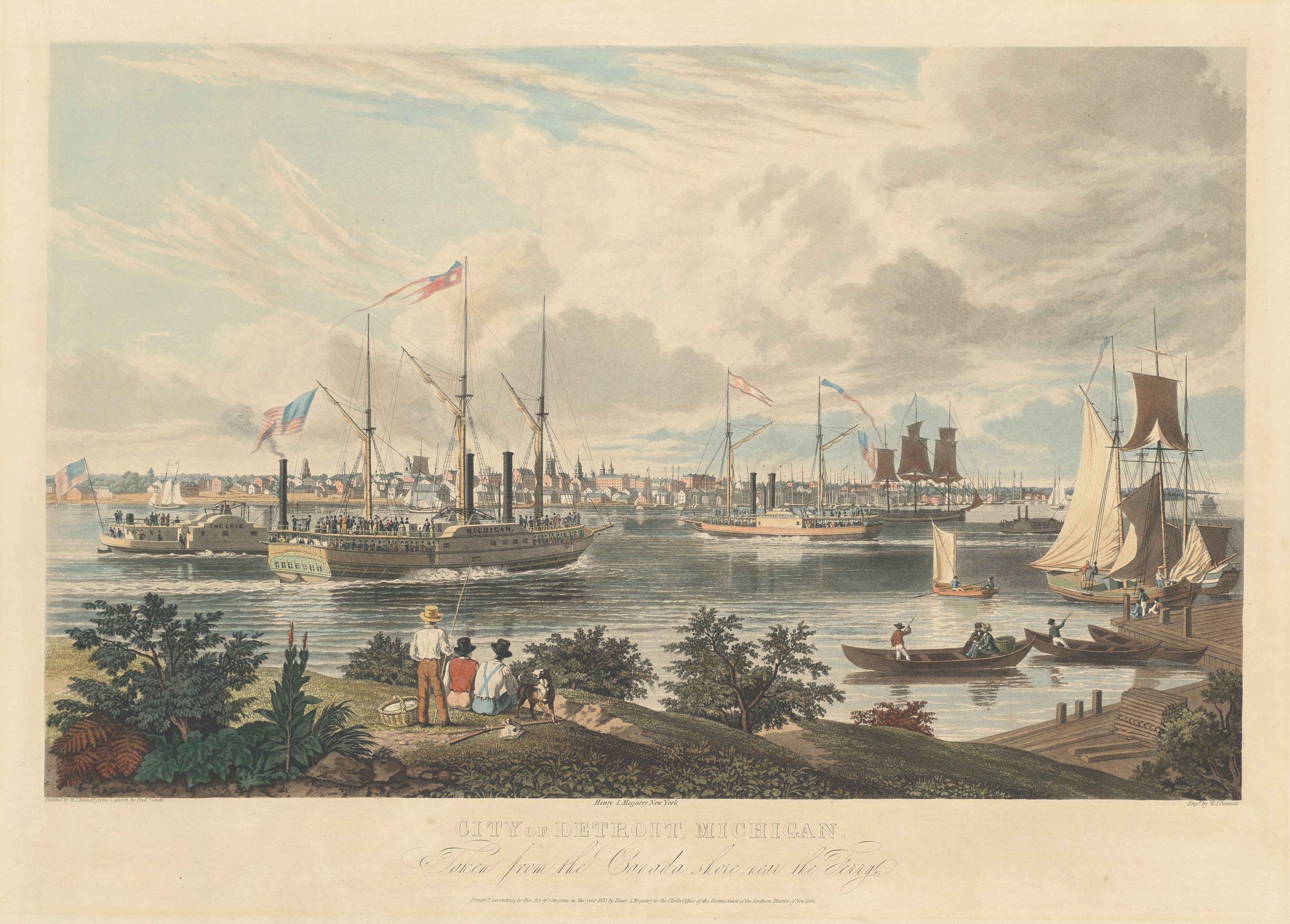
View of Detroit…1837
Here’s something really special for Clark House history lovers, a detailed drawing of the various kinds of sailing ships and steamboats as they passed by Detroit, Michigan on a sunny day in 1837, as seen from the Canadian side of the Detroit River. Take a close look; this is the view Peter Turck and his family—including daughter Mary, the future spouse of Jonathan M. Clark—would have seen as they traveled to Milwaukee in August of the same year1:
Bennett, William J., after a sketch by Frederick K. Grain, City of Detroit, Michigan. Taken from the Canada shore near the Ferry., hand-colored aquatint on engraving, ca. 1837. National Gallery of Art, Collection of Mr. and Mrs. Paul Mellon. Public Domain. Click to open larger image in new window.
Our “How’d they get here?” transportation series will continue shortly, starting with lots of info on Great Lakes steamboats. Here’s a teaser:
Catlin, George, Artist, and St. Louis Mercantile Library Association. St. Louis in 1832. From an original painting by Geo. Catlin in possession of the Mercantile Library Association.Library of Congress. Click to open larger image new window.
It was an eventful weekend. Congress—acting with a speed and unanimity1 unusual these days—declared a new federal holiday to celebrate June 19th as Juneteenth National Independence Day, formerly known and variously celebrated as Juneteenth, Emancipation Day, or Black Independence Day. It has roots in the issues and events of the Civil War years that I’m currently blogging about, and I’ll have more to share about the history of our newest federal holiday in a future post.
Sunday June 20 heralded the arrival of summer, and the observance of Fathers’ Day. In honor of both, I took the day off from writing and spent some time with my family. Wishing you all the best for summer, 2021, here’s an evocative seasonal print from Jonathan and Mary Clark’s era…