How’d they get here? – Westward on Lake Erie to Detroit

Our series of “How’d they get here?” posts is written to illustrate the nuts and bolts of how our early Mequon pioneers travelled from their original homes or ports of arrival in North America to the newly opened federal lands in Wisconsin Territory, circa 1830-1850. Today’s post continues our westward journey from Buffalo; see Note 1 (below) for links to other posts in the series.

On to the West!

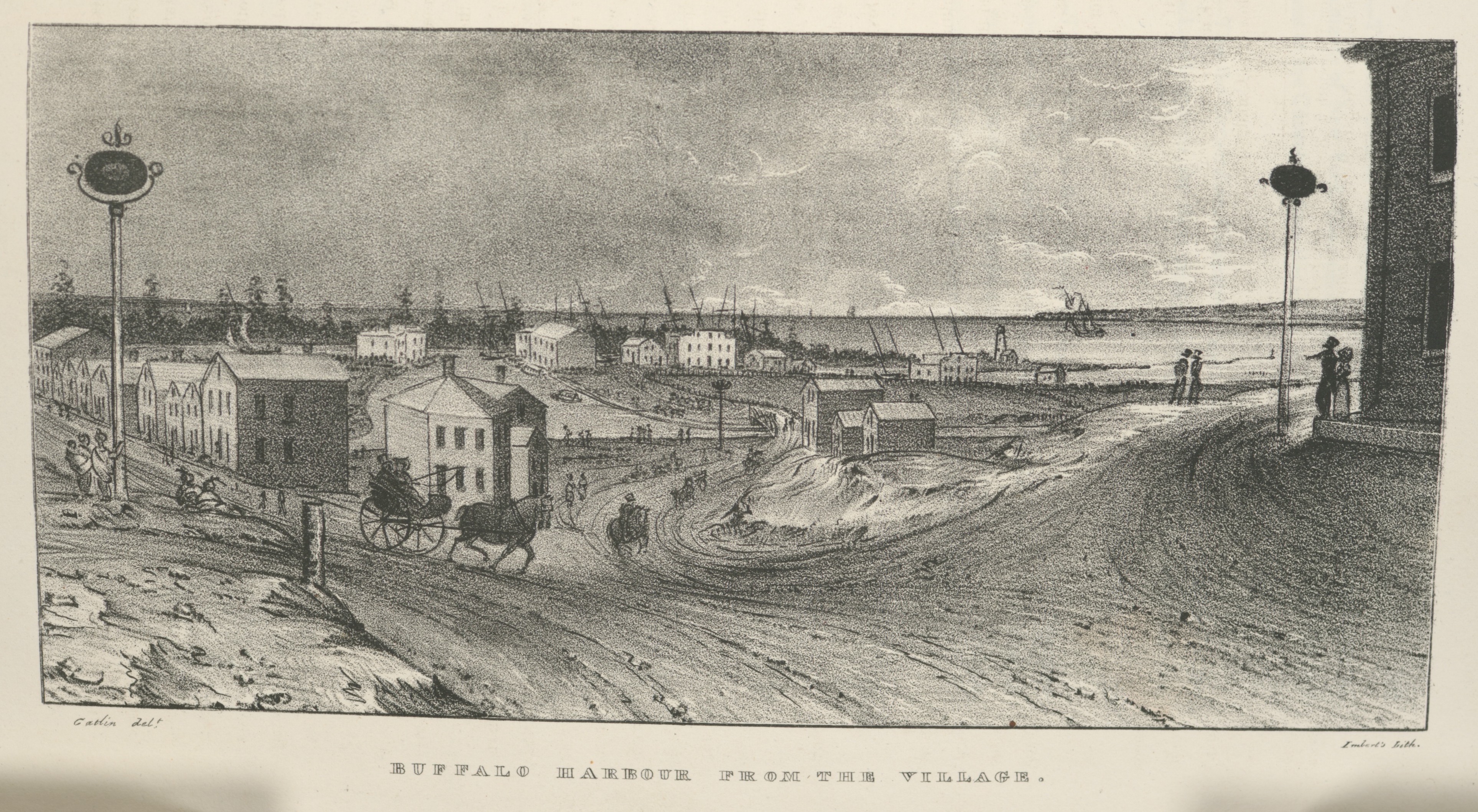
After traveling the Erie Canal and leaving Buffalo harbor, our westward emigrants would sail the length of Lake Erie, on their way to Lakes St. Clair, Huron, and Michigan and—eventually—landfall in the Wisconsin Territory.

Regular steamboat service between Buffalo and Detroit was available at least as early as 1825.2 The 330-mile route included scheduled stops in Erie, Pennsylvania, the mouth of the Grand River (at Fairport, Ohio), and the Ohio ports of Cleveland and Sandusky, before finally arriving at the city of Detroit. By the mid-1830s the number of stops had increased to serve other developing port towns along Lake Erie’s southern shore and points further on, including Green Bay, Milwaukee, and Chicago.

The Cleveland light, circa 1834

Day or night, fair weather or foul, our westbound Mequon settlers would have noticed a variety of sights along the way, including a handful of navigation lights constructed by the federal government. One of the most notable was the harbor light at Cleveland, Ohio.

Bodmer, Karl. “Leuchtthurm bei Cleveland am Erie See. Phare de Clevelandsur le Lac Erie. Cleveland Lighthouse on the Lake Erie.” The New York Public Library Digital Collections. Published 1840 – 1843, original drawing c. 1834. Click to open larger image in new window.

Continue reading

How’d they get here? Buffalo – a tale of two harbors

Our series of “How’d they get here?” posts is written to illustrate the nuts and bolts of how our early Mequon pioneers travelled from their original homes or ports of arrival in North America, to the newly opened federal lands in Wisconsin Territory, circa 1830-1850. See Note 1, below, for links to other posts in the series.

Village of Buffalo, 1825

In a previous post, we followed the newly-opened route for westward migrants from the New York City docks, up the Hudson River to Albany, and then along the new Erie Canal towards its terminus at the village of of Buffalo, New York, at the eastern end of Lake Erie. After seven days of travel on canal boats, the westbound traveler of 1825 would have looked up and seen this, the muddy streets and modest harbor of Buffalo:

Buffalo Harbour from the Village, in Cadwallader Colden, et. al., Memoir…at the Completion of the New York Canals, New York, 1825. Image from “extra-illustrated” edition in New York Public Library Digital Collections, scanned copy of standard edition of book via GoogleBooks. Public domain. Click to open larger image in new window.

After leaving the Deep Cut above Lockport, the last part of the Erie Canal merges with Tonawanda Creek, seen here flowing into the village from far left to center, in front of the line of distant trees, and then curving toward the viewer before exiting into the harbor, to the right. The original Buffalo lighthouse of 1818 can be see on a small peninsula, right of center, just above where Tonawanda Creek meets the lake.

Continue reading

But Wait! There’s More!

One of the really neat aspects of researching and writing about Clark House history on this site is the feedback I receive from blog readers. I love hearing from you, whether you have a comment or a question about the topic at hand, or perhaps there is something else that you want to know more about.

[Occupational Portrait of a Salesman], Three-Quarter Length, Seated, Displaying His Wares. Daguerreotype, between 1850 and 1860, cropped and lightly color-adjusted. Library of Congress. Click to open larger image in new window.

“UPDATED…”

History is never “done.” No one can know it all. There are always new sources with fresh information, and new ways to look at well-known material. A question or a new bit of information from a reader will often prompt additional research or a correction to previous statements. The result is that this blog—and our knowledge of the Clark family, their neighbors, and their era—is constantly evolving.

Continue reading

“J. M. Clarke” – Town Supervisor, 1846

Every now and then it pays to take a fresh look at familiar sources. One of the key sources for the early history of Mequon and its parent counties is The History of Washington and Ozaukee Counties, Wisconsin […] Illustrated, published in Chicago in 1881. And even though I’ve been using this book for Clark House research for over a decade, I still discover (or, in this case, re-discover) facts about Mequon—and, specifically, Jonathan M. Clark—that I had either not known before, or had noticed, “filed for future reference,” and forgotten to write about. Today’s post fixes one such omission.1

The first meeting of the Town of Mequon, April 7, 1846

Page 525 of The History… contains a load of information about the beginnings of town government in Spring, 1846. Unfortunately, it’s the sort of densely worded, 19th-century “history” writing that makes the reader want to skip ahead to something less dry. Here, take a look; start with the first full paragraph, beginning “The town was incorporated”…

The History of Washington and Ozaukee Counties, Wisconsin […] Illustrated, Western Historical Co., Chicago, 1881, page 525, pdf of full book via GoogleBooks. Additional online, pdf copies can be found at Hathi Trust, the Wisconsin Historical Society and Archive.org. Click to open larger image in new window.

That’s a lot of info: names, dates, job titles. Let’s break things up a bit and take a closer look at what’s going on as old Washington county transitioned from the original county-wide system of government to the new system, in which each town will be responsible for much of its own governance.

Continue reading

Gone fishing…

Well, I haven’t actually gone fishing, but I am taking another short break, and I thought I’d illustrate this with a historic drawing or lithograph of some Clark-era folks fishing. A little play on words. Just for fun and all.

The best I could do today—alas—was this 1848 political cartoon:

N. Currier. The Presidential fishing party of. United States, 1848. [New York: Pub. by Peter Smith i.e., Nathaniel Currier, 2 Spruce St., N.Y]. Library of Congress. Click to open larger image in new window; this is the only way to view the text clearly, by the way.

Like all political cartoons of the era it is heavy-handed, visually busy, and full of long-winded text, explaining some now-obscure but highly-contentious issue of the day in the most tedious manner possible. (This is why I usually avoid using 19th-century political cartoons to enliven the discussion here at Clark House Historian.)

What’s it all about?

Anyway, 1848 was an important year for the nation, and for our Mequon settlers. The war with Mexico ended, Wisconsin attained statehood and—closer to home—the Jonathan M. Clark house was built. This cartoon, verbose as it may be, actually covers some key issues of the 1848 U.S. presidential race. Here’s a helpful explanation from the staff at the Library of Congress (I’ve added a few paragraph breaks for easier reading):

Continue reading

River walk

There was still some daylight left after the annual “Pie on the Patio” event at the Clark House last week, so I thought I’d stop by Mequon’s historic Isham Day House on my way home. Isham Day was one of Mequon’s first settlers, and he built his tidy home, sometimes known as the “Yankee Settler’s Cottage,” in 1839. It’s a town landmark, and I’d never been to see it.

While enjoying my first look at the Day House, I also took the opportunity to meander through the adjacent Settlers Park. It’s a beautiful little park, with an accessible boardwalk that leads down to and along the west bank of the Milwaukee River. It’s a short, easy stroll; I highly recommend it. By the time you reach the riverbank you’ll forget you are in a busy 21st-century downtown.

Photo credit: Anna Perkins, 2021. Click any photo to open gallery and access larger versions of the images.

Continue reading

How’d they get here? Walking & riding

This is another installment in the transportation-themed series that began with our July 6, 2021, Monday: Map Day! – How’d they get here? and continues from there.

Queen, James Fuller, [A Man and a Woman Standing at the Entrance to a Trail Through a Forest] (detail), graphite drawing on cream paper, circa 1850-1870. Library of Congress

I’m still writing the next two (or three) longer, narrative installments of our “How’d they get here?” series, which I began working on to assist Clark House education director Margaret Bussone and our education team as they develop a transportation-themed project for use at the Jonathan Clark House later this summer.

For quite a while I was worried that I would not be able to find enough visual material to adequately illustrate our early Mequon immigrants’ journeys of the 1830s and ’40s. It turns out that I now have a lot of material to share with the education team—and with you. Rather than hold on to it until my longer posts are complete, I thought I’d do something different today.

Continue reading

Still steaming ahead…

I’m still working on the next two (or three) more substantial installments of our “How’d they get here?” series, so here’s another “bonus” post, while you’re waiting. If you need to catch up, the series began with our July 6, 2021, Monday: Map Day! – How’d they get here? and continues from there.

Some weeks ago, when I began to research this topic, I was worried; I didn’t think that I would be able to find enough information and visual material to adequately illustrate our Mequon immigrants’ journeys of the 1830s and ’40s. It turns out that I now have (cough) a boatload of material to sort through and organize. So more of “How’d they get here?” is coming soon. Meanwhile, here’s another fine Great Lakes steamer from the time of our Mequon pioneers:

N. Currier. Buffalo & Chicago steam packet Empire State: M. Hazard, Commander. New York, circa 1835-1856 (probably 1848 or later, see below). Photograph of hand-colored lithograph. Library of Congress. Click to open larger image in a new window.

Continue reading