Our “How’d they get here?” transportation series will continue shortly, starting with lots of info on Great Lakes steamboats. Here’s a teaser:
Catlin, George, Artist, and St. Louis Mercantile Library Association. St. Louis in 1832. From an original painting by Geo. Catlin in possession of the Mercantile Library Association.Library of Congress. Click to open larger image new window.
UPDATED, February 11, 2024, to include a revised version of the annotated detail map of Ouisconsin, 1836. But for the full update—with additional notes and corrections—please see the most recent version of our discussion the Ouisconsin map of 1836 on our post of February 12, 2024. UPDATED, July 6, 2021, to answer a reader’s question: “Where was Jonathan Clark just before he went to Fort Howard?” Scroll down to Comments for the answer.
How the early settlers came to Mequon, c. 1835-1850 (part 1)
Clark House education director Margaret Bussone and our education team are putting together a project centered on how our Mequon pioneers traveled to southeast Wisconsin in the early days of white settlement, between roughly 1835 and 1850. I thought I’d help out by gathering some relevant materials and sharing them with the education team—and you—here on the blog.1
So this week we’re going to look at how the settlers found their way here, and how they traveled on land, lake, or river. Rather than writing lots of words about each map or image, I’d like to gather a whole bunch of useful items in each post and put them out there as resources for all to use. Later in the week, we’ll look at various modes of travel on land and on water. Today we’ll look at some maps.2 Some of these maps were readily available to our would-be immigrants, others might have been one-of-a-kind or otherwise hard to obtain.
An overview, The U.S. in 1834
When the following map was published in 1834, Jonathan M. Clark was finishing the first year of his three-year enlistment in the U.S. army. He was stationed at Ft. Howard, on the Green Bay of Lake Michigan, in what was then the civil District of Huron, a soon-to-be-outdated term for the western portion of the Michigan Territory.3
Mequon’s earliest settlers would be coming to lands that were poorly mapped and little understood by most European-Americans. The most this map could show—in a very general way—is where the “open” areas were for future migration and settlement.
Norris, William, and Daniel K Minor. Map of the railroads and canals, finished, unfinished, and in contemplation, in the United States. New York: Railroad Journal, 1834. Map. Library of Congress. Click to open larger map in new window.
I need to make a correction. In one of the previous posts of our Infrastructure! series, I wrote:
In early 1841, before the commissioners approved county roads Nos. 1, 2, and 3, there was already one federal road in the county. The Green Bay road was a federal road […]. It ran generally south to north, joining Ft. Dearborn in Chicago to […] Ft. Howard in Green Bay. Along the way it passed through a number of growing settlements including the three villages that would become Milwaukee, and the future towns of Mequon, Cedarburg, and Grafton.
That’s almost accurate. To be precise, I should have said there was one federal road in the southeast corner of the county—the part that would become the towns of Mequon, Cedarburg and Grafton—the Green Bay road. But, if you consider the whole of old Washington county, there were not one, but two federal roads prior to 1841, the north-south Green Bay road and the east-west Dekorra road.
Both of these roads appear on the first map of Wisconsin Territory drawn from official government surveys, published in 1837. The two federal roads are indicated on the original map by closely-spaced parallel gray lines. On the detail below I’ve highlighted the then-existing eastern portion of the Dekorra road in blue, and the Washington county portion of the Green Bay road in green:
This is a revised and updated version of a post that originally appeared here on May 25, 2020. Please be sure to read the Notes & Updates, below, for new information.
Lest We Forget
Graves of Unknown Union Soldiers, Memphis National Cemetery, photo by Clayton B. Fraser, (Library of Congress), public domain. Memphis National Cemetery is the final resting place of Mequon’s Watson Peter Woodworth, and almost 14,000 of his Union Army comrades.
As we begin to recover1 from the worst pandemic in a century, a quick glance at the news will show that many Americans are celebrating this “Memorial Day Weekend” in our now usual way, as “the first day of summer.” Beaches and parks are open, stores entice customers with deals and sales, and people are crowding shoulder to shoulder in swimming pools and along ocean boardwalks.
But for many of us, Memorial Day remains rooted in its origins as Decoration Day. The first national observance was in 1868, when retired general John A. Logan, commander and chief of the Grand Army of the Republic—the Union veterans’ organization—issued his General Order Number 11, designating May 30 as a memorial day “for the purpose of strewing with flowers or otherwise decorating the graves of comrades who died in defense of their country during the late rebellion, and whose bodies now lie in almost every city, village, and hamlet churchyard in the land.”
This Memorial Day, let’s remember those Clark House family, friends, and Mequon neighbors who served in the Civil War, and what they fought—and died—for. The History of Washington and Ozaukee Counties (1881) lists these 65 volunteers from Mequon:
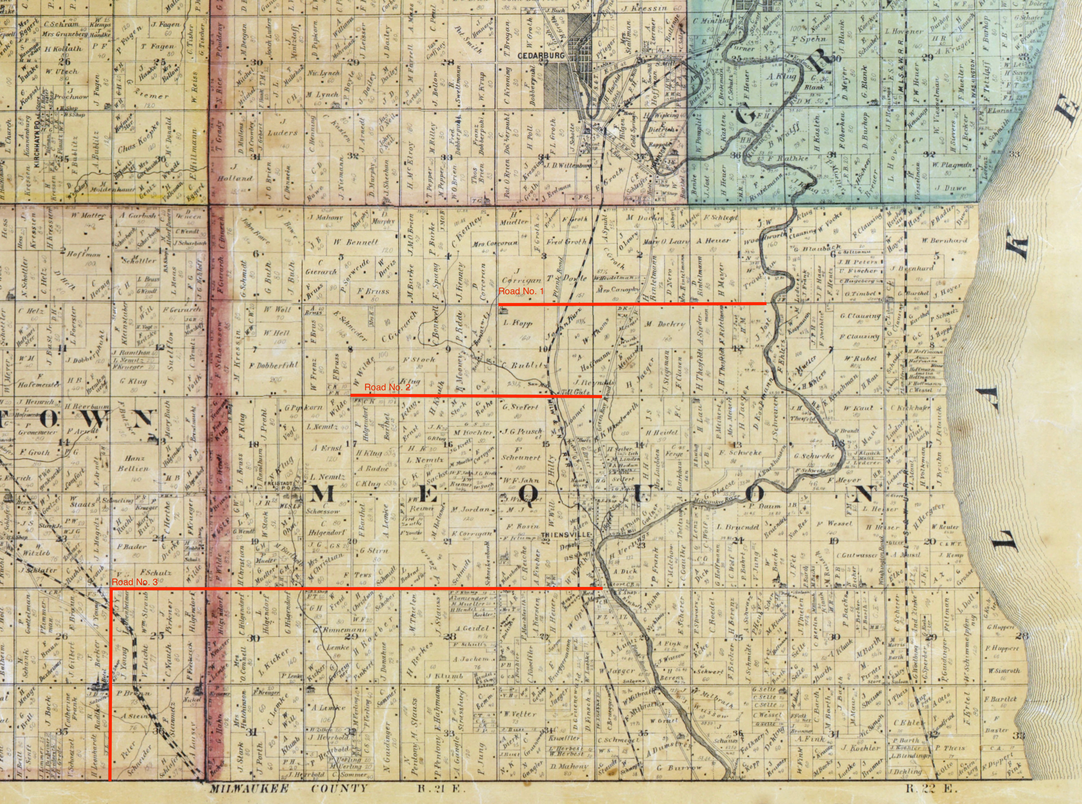
Another episode in our Infrastructure! series, a group of posts focused on the first government “improvements” in old Washington/Ozaukee county. If you need to catch up, start with Monday: Map Day – The First County Roads, 1841, then Marking Out the Roads, and our most recent post, Roads into the Woods, 1841, where we rediscovered the routes of old Washington/Ozaukee county’s very first roads.
First federal and county roads
In early 1841, before the commissioners approved county roads Nos. 1, 2, and 3, there was already one federal road in the county. The Green Bay road was a federal road, cut by the troops of the U.S. army’s 5th regiment. It ran generally south to north, joining Ft. Dearborn in Chicago to the regiment’s headquarters at Ft. Howard in Green Bay. Along the way it passed through a number of growing settlements including the three villages that would become Milwaukee, and the future towns of Mequon, Cedarburg, and Grafton. On the map below the Green Bay road is west of and occasionally parallels the Milwaukee River. It is sometimes labeled Green Bay Road, and sometimes—in the southern part of this map—Plank Road (the planking came later, in the 1850s).
Mapping out the first three Washington/Ozaukee county roads is not difficult. The proposals by the road supervisors, as recorded in the official minutes1, were quite precise. Clear starting and ending points were given, using the standard terminology of towns, ranges, sections, quarter sections and so on, and the lengths of each proposed road had been precisely measured in miles, with fractional miles given as a number of additional chains, rods or links. A map of those first three roads—superimposed on a later map of Washington and Ozaukee counties from 1874—looks like this:
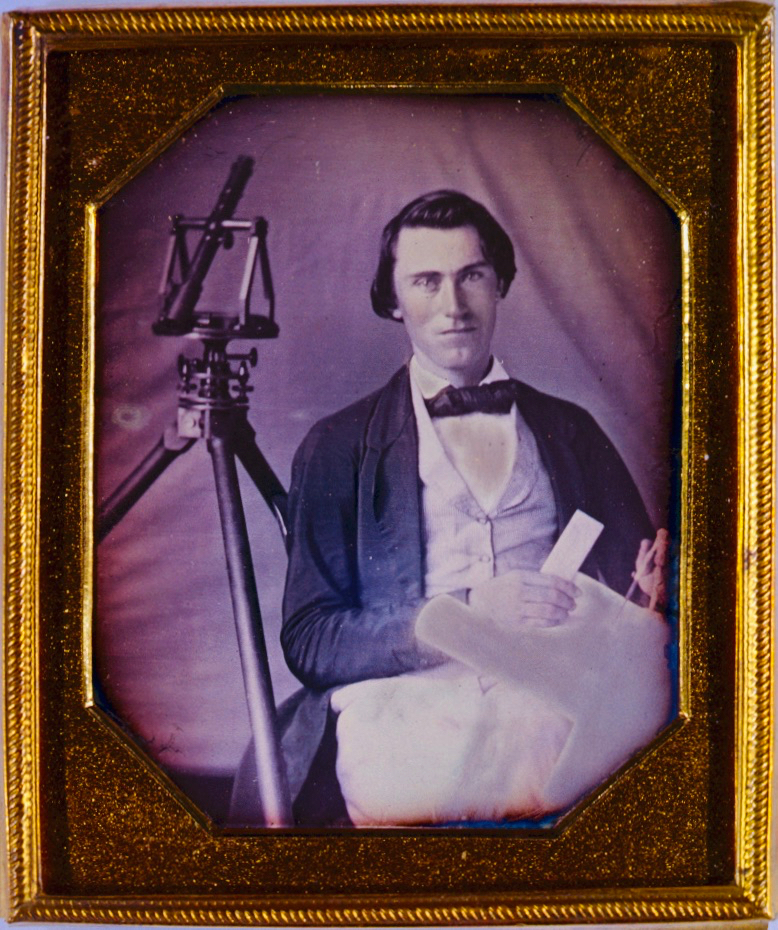
Our Infrastructure! series— a short group of posts focused on the first county government “improvements” in old Washington/Ozaukee county began (almost a month ago!) with Monday: Map Day!, discussing the 1841 appointment of the first county road supervisors and the organization of the county’s first seven road districts. That was followed up with a discussion of surveyors, their tools, and Jonathan M. Clark’s experiences as a military road builder. Today we’ll take a look at the first few roads laid out and built in old Washington/Ozaukee county in early 1841.
It’s been a busy few weeks here at the Historian’s (actual) house, and I’m (very) slowly transcribing handwritten documents and making maps to illustrate the work of Jonathan M. Clark and his fellow road supervisors as they mapped and built old Washington County’s first roads in early 1841. While you’re waiting for those posts, check out our previous installments in this series — County Government – Early Records and Monday: Map Day! — for some interesting background, maps, and first-hand records.
Jonathan Clark – surveyor?
What did Jonathan Clark know about surveying and road building? Probably quite a bit. Like most farmers—then and now—Jonathan would not have been successful without a good understanding of maps, distances, land boundaries and how to best use and navigate the fields, forests and wetlands of his property.
If you recall our earlier posts detailing JMC’s military service (starting with Fort Howard, October 1833 (part 1) and including Ouisconsin Territory, 1836), you’ll remember that his unit, the U.S. Army’s 5th infantry regiment, was responsible for laying out and cutting the new military road that would ultimately connect Ft. Howard in Green Bay, Ft. Winnebago near Portage, and Ft. Crawford at Prairie du Chien. Jonathan’s Co. K was involved in this work for the better part of his final two years of service (1835-1836). This assignment would give him hands-on experience in surveying, map-making, grubbing out roads and building serviceable bridges with the materials at hand. By the time he arrived in Mequon, in late 1839, it’s possible that Jonathan Clark was the most experienced road builder (and one of the better surveyors) in early Washington/Ozaukee county.
Last week’s Monday: Map Day! discussed the Milwaukee and Superior railroad, and the right-of-way through the middle of the Clark farm property that it purchased from Jonathan and Mary Clark in 1857. Even if you already read it, take another look. I’ve recently updated that post to include corrections and new information from reader Sam Cutler (thanks, Sam!).
Today’s post begins Infrastructure Week! a short series focused on the first infrastructure projects in old Washington/Ozaukee county, beginning with the 1841 appointment of the first county road supervisors and their districts.
Old Washington/Ozaukee County, 1837
In order to proceed with county business, the original county commissioners must have had an authoritative map that showed the official county and township boundaries. I would not be surprised if they owned a copy of the 1837 Topographical map of Wisconsin Territory, showing the lands that had been surveyed by, and were available for purchase from, the federal government. As we discussed earlier, this was the first large-scale map of the Wisconsin Territory based on actual surveys. Here’s a detail from that map, showing old Washington county as the 1841 county commissioners would have understood it:
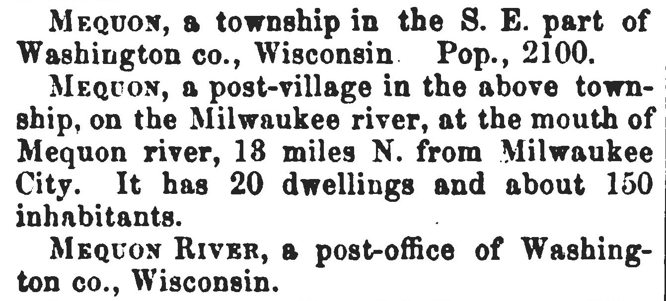
Mequon is the home of the Jonathan M. Clark House. Mequon is a unique name, and its source, pronunciation, spelling—and, occasionally, location—are the source of a fair amount of confusion and error. So I thought I would gather a few pertinent facts about the name that might help readers avoid some of the pitfalls in Mequon research.
As a reminder:
Baldwin, Thomas and J. Thomas, M.D., A New and Complete Gazetteer of the United States […], Philadelphia,1854, p. 687. Via GoogleBooks.
That’s a pretty accurate, “just the facts,” description of Mequon in 1854. (Although it looks like Gazetteer editors Baldwin and Thomas didn’t get the news that on March 7, 1853, the east part of Washington county—including the Town of Mequon—had split from its parent county to form the new Ozaukee county. And the town vs. township distinction could be more precise, too.)
There were a lot of deadly, infectious diseases in 19th-century North America. When Jonathan M. Clark was young, the causes and cures for most of these illnesses were a mystery. Germ theory was unknown, and for many people hygiene was, at best, a hit-or-miss affair. But even in that era, we can be certain Jonathan M. Clark was inoculated against one of the worst recurring plagues of all time: smallpox.
General Regulations of the U.S. Army, 1821, Art. 73, no. 90