“J. M. Clarke” – Town Supervisor, 1846

Every now and then it pays to take a fresh look at familiar sources. One of the key sources for the early history of Mequon and its parent counties is The History of Washington and Ozaukee Counties, Wisconsin […] Illustrated, published in Chicago in 1881. And even though I’ve been using this book for Clark House research for over a decade, I still discover (or, in this case, re-discover) facts about Mequon—and, specifically, Jonathan M. Clark—that I had either not known before, or had noticed, “filed for future reference,” and forgotten to write about. Today’s post fixes one such omission.1

The first meeting of the Town of Mequon, April 7, 1846

Page 525 of The History… contains a load of information about the beginnings of town government in Spring, 1846. Unfortunately, it’s the sort of densely worded, 19th-century “history” writing that makes the reader want to skip ahead to something less dry. Here, take a look; start with the first full paragraph, beginning “The town was incorporated”…

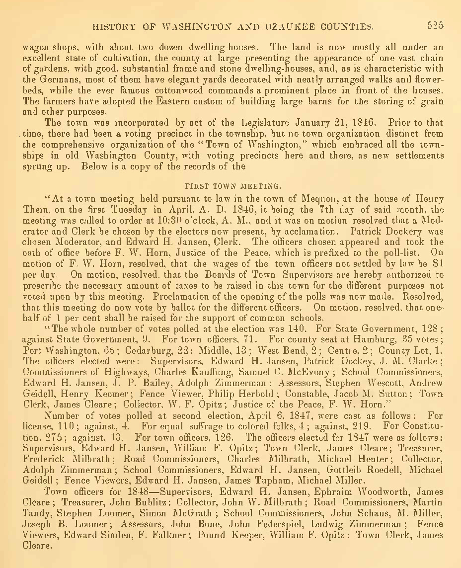
The History of Washington and Ozaukee Counties, Wisconsin […] Illustrated, Western Historical Co., Chicago, 1881, page 525, pdf of full book via GoogleBooks. Additional online, pdf copies can be found at Hathi Trust, the Wisconsin Historical Society and Archive.org. Click to open larger image in new window.

That’s a lot of info: names, dates, job titles. Let’s break things up a bit and take a closer look at what’s going on as old Washington county transitioned from the original county-wide system of government to the new system, in which each town will be responsible for much of its own governance.

Continue reading

River walk

There was still some daylight left after the annual “Pie on the Patio” event at the Clark House last week, so I thought I’d stop by Mequon’s historic Isham Day House on my way home. Isham Day was one of Mequon’s first settlers, and he built his tidy home, sometimes known as the “Yankee Settler’s Cottage,” in 1839. It’s a town landmark, and I’d never been to see it.

While enjoying my first look at the Day House, I also took the opportunity to meander through the adjacent Settlers Park. It’s a beautiful little park, with an accessible boardwalk that leads down to and along the west bank of the Milwaukee River. It’s a short, easy stroll; I highly recommend it. By the time you reach the riverbank you’ll forget you are in a busy 21st-century downtown.

Photo credit: Anna Perkins, 2021. Click any photo to open gallery and access larger versions of the images.

Continue reading

Monday: Map Day! – How’d they get here?

UPDATED, February 11, 2024, to include a revised version of the annotated detail map of Ouisconsin, 1836. But for the full update—with additional notes and corrections—please see the most recent version of our discussion the Ouisconsin map of 1836 on our post of February 12, 2024.
UPDATED, July 6, 2021, to answer a reader’s question: “Where was Jonathan Clark just before he went to Fort Howard?” Scroll down to Comments for the answer.

How the early settlers came to Mequon, c. 1835-1850 (part 1)

Clark House education director Margaret Bussone and our education team are putting together a project centered on how our Mequon pioneers traveled to southeast Wisconsin in the early days of white settlement, between roughly 1835 and 1850. I thought I’d help out by gathering some relevant materials and sharing them with the education team—and you—here on the blog.1

So this week we’re going to look at how the settlers found their way here, and how they traveled on land, lake, or river. Rather than writing lots of words about each map or image, I’d like to gather a whole bunch of useful items in each post and put them out there as resources for all to use. Later in the week, we’ll look at various modes of travel on land and on water. Today we’ll look at some maps.2 Some of these maps were readily available to our would-be immigrants, others might have been one-of-a-kind or otherwise hard to obtain.

An overview, The U.S. in 1834

When the following map was published in 1834, Jonathan M. Clark was finishing the first year of his three-year enlistment in the U.S. army. He was stationed at Ft. Howard, on the Green Bay of Lake Michigan, in what was then the civil District of Huron, a soon-to-be-outdated term for the western portion of the Michigan Territory.3

Mequon’s earliest settlers would be coming to lands that were poorly mapped and little understood by most European-Americans. The most this map could show—in a very general way—is where the “open” areas were for future migration and settlement.

Norris, William, and Daniel K Minor. Map of the railroads and canals, finished, unfinished, and in contemplation, in the United States. New York: Railroad Journal, 1834. Map. Library of Congress. Click to open larger map in new window.

Continue reading

Henry Clark’s last days

UPDATED, June 30, 2021 to add an endnote.

What we do — and don’t — know about the Clarks’ only son (part 4)

This is the fourth in a series of posts about Henry Clark, his life, and his possible military service.
• Part 1: Meet the Children: Henry M. Clark
• Part 2: Henry Clark and the Civil War draft
• Part 3: Henry Clark – Civil War draftee
• and a related tidbit: Avoiding the draft, 1862 style

In our previous post, we discovered that Henry M. Clark was drafted for Civil War military service on November 10, 1863. Today we will look at the existing evidence recording Henry’s death and burial in April, 1866, aged 23. So far, we lack reliable documentation for Henry’s life during the 28 months between those dates; we’ll continue the search for Henry’s possible Civil War service in a series of upcoming posts.

The question remains: why did Henry Clark, only son of Jonathan M. and Mary (Turck) Clark, die so young? Milwaukee death records for the 1860s are uneven and incomplete; it’s not surprising that no death certificate exists. I have not been able to find a death notice in the Milwaukee newspapers. But we do have two contemporary sources that can shed some light onto the mystery of this Clark family loss.

Densmore W. Maxon’s 1866 diary

On April 2, 1846, Mary Turck Clark’s younger sister Elizabeth Turck (1828-1913) married an ambitious young settler, Densmore W. Maxon (1820-1887). Maxon began his Wisconsin years as a surveyor, and eventually rose to prominence as a businessman and politician. He laid out the village of Cedar Creek, Town of Polk, Washington county, about 18 miles north and west of the Jonathan Clark house in Mequon. Densmore and Elizabeth Maxon lived in Cedar Creek for the next 41 years.

The lives of the Maxons, Clarks and Turcks are deeply intertwined from the 1840s onwards. For at least one year, 1866, Densmore Maxon kept a pocket diary. These pages contain his notes on the final days of nephew, Henry Clark:

Continue reading

The county’s earliest federal roads (plural)

I need to make a correction. In one of the previous posts of our Infrastructure! series, I wrote:

In early 1841, before the commissioners approved county roads Nos. 1, 2, and 3, there was already one federal road in the county. The Green Bay road was a federal road […]. It ran generally south to north, joining Ft. Dearborn in Chicago to […] Ft. Howard in Green Bay. Along the way it passed through a number of growing settlements including the three villages that would become Milwaukee, and the future towns of Mequon, Cedarburg, and Grafton. 

That’s almost accurate. To be precise, I should have said there was one federal road in the southeast corner of the county—the part that would become the towns of Mequon, Cedarburg and Grafton—the Green Bay road. But, if you consider the whole of old Washington county, there were not one, but two federal roads prior to 1841, the north-south Green Bay road and the east-west Dekorra road.

Both of these roads appear on the first map of Wisconsin Territory drawn from official government surveys, published in 1837. The two federal roads are indicated on the original map by closely-spaced parallel gray lines. On the detail below I’ve highlighted the then-existing eastern portion of the Dekorra road in blue, and the Washington county portion of the Green Bay road in green:

Continue reading

Another Road into the Woods, 1841

An Infrastructure Week Fortnight Month mystery!

Another episode in our Infrastructure! series, a group of posts focused on the first government “improvements” in old Washington/Ozaukee county. If you need to catch up, start with Monday: Map Day – The First County Roads, 1841, then Marking Out the Roads, and our most recent post, Roads into the Woods, 1841, where we rediscovered the routes of old Washington/Ozaukee county’s very first roads.

First federal and county roads

In early 1841, before the commissioners approved county roads Nos. 1, 2, and 3, there was already one federal road in the county. The Green Bay road was a federal road, cut by the troops of the U.S. army’s 5th regiment. It ran generally south to north, joining Ft. Dearborn in Chicago to the regiment’s headquarters at Ft. Howard in Green Bay. Along the way it passed through a number of growing settlements including the three villages that would become Milwaukee, and the future towns of Mequon, Cedarburg, and Grafton. On the map below the Green Bay road is west of and occasionally parallels the Milwaukee River. It is sometimes labeled Green Bay Road, and sometimes—in the southern part of this map—Plank Road (the planking came later, in the 1850s).

Mapping out the first three Washington/Ozaukee county roads is not difficult. The proposals by the road supervisors, as recorded in the official minutes1, were quite precise. Clear starting and ending points were given, using the standard terminology of towns, ranges, sections, quarter sections and so on, and the lengths of each proposed road had been precisely measured in miles, with fractional miles given as a number of additional chains, rods or links. A map of those first three roads—superimposed on a later map of Washington and Ozaukee counties from 1874—looks like this:

Continue reading

Roads into the Woods, 1841

Infrastructure Week Fortnight Month continues!

Our Infrastructure! series— a short group of posts focused on the first county government “improvements” in old Washington/Ozaukee county began (almost a month ago!) with Monday: Map Day!, discussing the 1841 appointment of the first county road supervisors and the organization of the county’s first seven road districts. That was followed up with a discussion of surveyors, their tools, and Jonathan M. Clark’s experiences as a military road builder. Today we’ll take a look at the first few roads laid out and built in old Washington/Ozaukee county in early 1841.

Continue reading

Preparing for planting

Revised May 13, 2022 to correct spelling of Nathaniel Currier’s name.

It’s mid-May in southeastern Wisconsin, and with luck the last frost is behind us. For the past weeks and months farmers and gardeners have been tending to the soil and preparing for planting. At this time of year in the 1840s and ’50s, Jonathan M. Clark would have done much the same, hitching up his team of oxen to a steel-bladed plow to cut and turn over the tough prairie grasses and break up the soil of his newly-cleared lands.

Continue reading

Marking out the roads

Infrastructure Week Fortnight Month continues…

It’s been a busy few weeks here at the Historian’s (actual) house, and I’m (very) slowly transcribing handwritten documents and making maps to illustrate the work of Jonathan M. Clark and his fellow road supervisors as they mapped and built old Washington County’s first roads in early 1841. While you’re waiting for those posts, check out our previous installments in this series — County Government – Early Records and Monday: Map Day! — for some interesting background, maps, and first-hand records.

Jonathan Clark – surveyor?

What did Jonathan Clark know about surveying and road building? Probably quite a bit. Like most farmers—then and now—Jonathan would not have been successful without a good understanding of maps, distances, land boundaries and how to best use and navigate the fields, forests and wetlands of his property.

If you recall our earlier posts detailing JMC’s military service (starting with Fort Howard, October 1833 (part 1) and including Ouisconsin Territory, 1836), you’ll remember that his unit, the U.S. Army’s 5th infantry regiment, was responsible for laying out and cutting the new military road that would ultimately connect Ft. Howard in Green Bay, Ft. Winnebago near Portage, and Ft. Crawford at Prairie du Chien. Jonathan’s Co. K was involved in this work for the better part of his final two years of service (1835-1836). This assignment would give him hands-on experience in surveying, map-making, grubbing out roads and building serviceable bridges with the materials at hand. By the time he arrived in Mequon, in late 1839, it’s possible that Jonathan Clark was the most experienced road builder (and one of the better surveyors) in early Washington/Ozaukee county.

A surveyor and his tools…

Continue reading

Happy 200th Birthday, Mary!

Today, May 3, 2021, marks the 200th birthday anniversary of Mary Turck, the eldest child of Peter Turck and Rachael (Gay) Turck, and future spouse of Jonathan M. Clark. Mary and Jonathan were married in old Washington county on March 15, 1840, and began to farm their Mequon land the same year. They went on to build their handsome stone house—now the Jonathan Clark House Museum—in 1848.

Continue reading