More on JMC’s path from New York to Fort Howard, 1833
In our post How’d they get here? – JMC to Ft.Howard, 1833., I surmised that new army recruit Jonathan M. Clark mustered in at Ft. Niagara, New York, and then went from there to join his regiment at Fort Howard, Green Bay, Michigan (later Wisconsin) Territory. I’ve since discovered two newspaper items that support that surmise. Here’s one from Spring, 1833, about five months before JMC signed his enlistment papers in Utica, New York:
[Recruits travel from Ft Niagara to Buffalo], dateline Buffalo, May 22, reprinted in [Philadelphia] Daily Chronicle, May 29, 1833, page 3. genealogybank.com. Click image to open image in new window.
On May 22, 1833, ninety fresh U.S. Army recruits marched from the army’s personnel depot at Ft. Niagara to “Tonawanta,” presumably the New York village of Tonawanda, located where Tonawanda Creek, the final stretch of the westbound Erie Canal, meets the Niagara River:
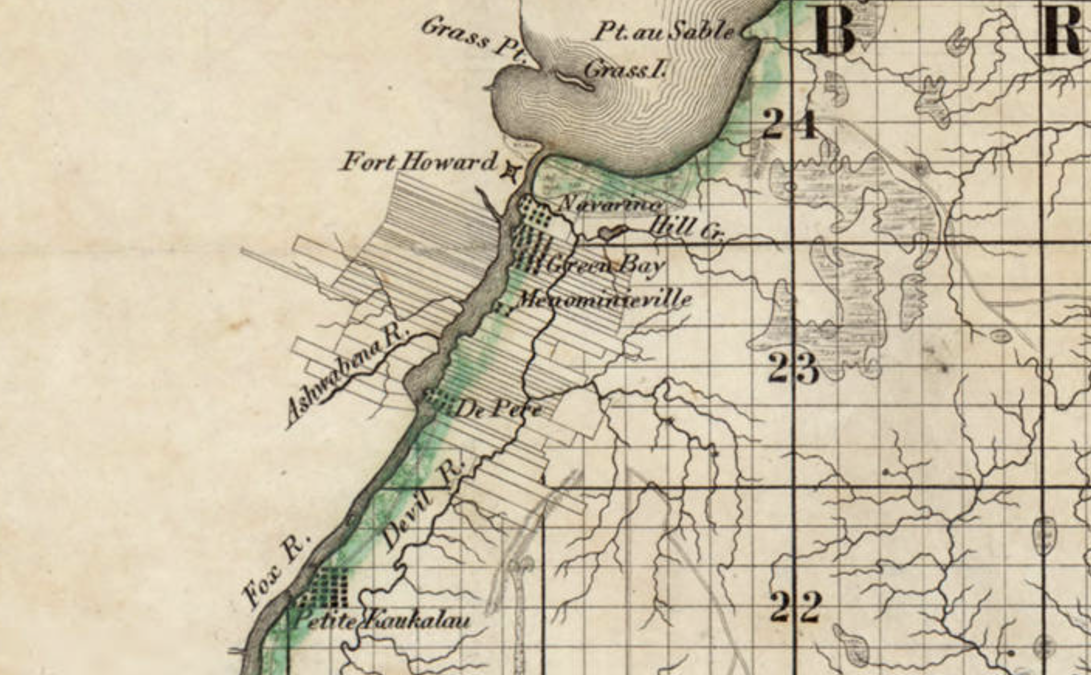
Last time, we illustrated our look at Ft. Howard with this detail from the first widely-available map of Wisconsin—and the first map of the territory based on official surveys—published in 1837:
Detail, Topographical map of Wisconsin Territory / compiled from the Public Surveys on file in the Surveyor General’s office … by Samuel Morrison, Elisha Dwelle [and] Joshua Hathaway, 1837. American Geographical Society Library Digital Map Collection, University of Wisconsin–Milwaukee. Click the detail map to open a larger version in a new window. Click here for a link to the complete map at UW-M with full bibliographic information.
This detail—showing Fort Howard, Navarino and, at the top, the southern end of Green Bay—was the subject of a Monday: Map Day! post in December, 2020, and gives a good picture of the topography and settled areas along the final miles of the Fox River as it empties into Green Bay. But on closer look, the details of the fort and its layout are very vague, limited to one X-shaped symbol. For a better understanding of Fort Howard in its most active era, we need to look at the actual 1823/1827 federal survey upon which the 1837 map was based:
Private Claims at Green Bay, 1823/1827
Detail, [Title section] of map, Private Claims at Green Bay, surveyed in July, Aug.t & Sept.r 1823; see image of complete map for full citation. Click to open larger image in new window.
Our series of “How’d they get here?” posts is written to illustrate the nuts and bolts of how our early Mequon pioneers travelled from their original homes or ports of arrival in North America to the newly opened federal lands in Wisconsin Territory, circa 1830-1850. Today’s post continues our previous post, a first-person description of 1830s frontier tourism that we called How’d they get here? Detroit to Ft. Howard, 1834 (part 1).
Picking up where we left off…
Wednesday, July 16, arrival at Green Bay
On Wednesday, as the Sun was slowly sinking to its repose in cloud of the most gorgeous and variegated colors, we arrived at the extremity of Green Bay, and about two miles up the Fox river, we landed at Navarino,2 receiving as we passed a salute from Fort Howard, on the opposite side of the river.
Detail, Topographical map of Wisconsin Territory / compiled from the Public Surveys on file in the Surveyor General’s office … by Samuel Morrison, Elisha Dwelle [and] Joshua Hathaway, 1837. American Geographical Society Library Digital Map Collection, University of Wisconsin–Milwaukee. Click the detail map to open a larger version in a new window. Click here for a link to the complete map at UW-M and its bibliographic information.
This map detail—showing Fort Howard, Navarino and, at the top, the southern end of Green Bay— is from the Topographical map of Wisconsin Territory, published in 1837 and the subject of a Monday: Map Day! post in December, 2020. As a reminder, this 1837 map shows all the lands officially surveyed by the federal government up to the time of publication. In 1837, the territory to the north and west of the Fox and Wisconsin rivers was still reserved for Wisconsin’s Native Americans, so the lands to the north and west of the Fox River are left (mostly) blank on this official map. But this land was not at all “empty.” The Indians, the forests, the wildlife, some of the old Métis and Anglo-American settlers—and the army—were all on the left bank of the Fox River in 1837, as they were in 1834, when the steamboat Michigan and its passengers arrived in Green Bay.
Our series of “How’d they get here?” posts is written to illustrate the nuts and bolts of how our early Mequon pioneers travelled from their original homes or ports of arrival in North America to the newly opened federal lands in Wisconsin Territory, circa 1830-1850. Today’s post looks at another trip to Ft. Howard on the steamboat Michigan, this time in the summer of 1834.
In Monday’s How’d they get here? – JMC to Ft.Howard, 1833, we looked at the likely probability that from October 16 – 30, 1833, Pvt. Jonathan M. Clark left the U.S. Army’s recruiting depot at Ft. Niagara, New York, and traveled the Great Lakes from Buffalo, New York, to his new post at Fort Howard, Green Bay, Michigan (later Wisconsin) Territory. To make that late-season journey the army chartered the new and lavishly appointed steamboat Michigan.
Great Lakes Tourism – Summer, 1834
Less than a year after that October, 1833, voyage the owners of the Michigan announced two special excursions to the “Far West” for the summer of 1834. The first of these was scheduled to leave Buffalo on Thursday, July 10, headed to “the Sault St. Marie (foot of Lake Superior), Michigan and Green Bay, touching at the ports on Lake Erie and at Detroit,” and would “embrace a distance of nearly 2000 miles, during which, passengers will have an opportunity of viewing the splendid scenery of Lakes Erie, St. Clair, Huron, Superior and Michigan, and the rivers, straits and bays connected with them.”
“Steamboat excursion to the Far West,” advertisement, Albany Argus, June 6, 1834, page 3, via genealogybank.com. Click to open larger image in new window.
The second trip would depart Buffalo on August 12th, and would take in all the sights of the July trip, and additional notable points along the south and east coasts of Lake Michigan, including Chicago, Michigan City, “St. Josephs,” and the mouth of Michigan’s Grand River. What could an 1834 tourist to the “Far West” expect on such an excursion? We have a first-hand report from the July trip, which includes an eventful stop at Jonathan M. Clark’s post at Ft. Howard.
Our series of “How’d they get here?” posts is written to illustrate the nuts and bolts of how our early Mequon pioneers travelled from their original homes or ports of arrival in North America to the newly opened federal lands in Wisconsin Territory, circa 1830-1850. Today’s post looks at how Jonathan M. Clark may have made the trip west to Wisconsin in October, 1833. And, in the process, we correct an important, but incorrect, date in the JMC timeline.
Jonathan M. Clark heads west…
Back in June, 2016, I outlined what we knew about Jonathan Clark’s 1833 enlistment in the army and subsequent journey to Green Bay:
After enlisting in the Army in Utica, New York, on September 19 and confirming his enlistment on September 28, 1833, Jonathan was sent to one of the Army’s “general depots.” I’ve not yet established which one he went to; the most likely places were the Jefferson Barracks in St. Louis, Missouri, or Kentucky’s Newport Barracks, on the south side of the Ohio River, across from Cincinnati. It’s possible that Jonathan may have reported to another “depot,” perhaps Ft. Niagara, New York, which was the home base of JMC’s recruiter, Capt. Clitz.
In any case, less than a month later Jonathan arrived at Fort Howard, Michigan [later Wisconsin] Territory. Fort Howard was the headquarters of the army’s Fifth Regiment, with easy water access via Lake Michigan to Ft. Dearborn, Chicago and, via the Fox and Wisconsin rivers, to Forts Winnebago and Crawford.
Now that we know more about early transportation routes from New York to Wisconsin it seems unlikely that JMC reported to either the Jefferson Barracks or the Newport Barracks before arriving at Fort Howard. Yes, it would have been relatively easy to travel from Utica, New York, to either the Jefferson or Newport barracks via the Erie Canal to Lake Erie, and then the Ohio canals and Ohio river. But Fort Howard was one of the army’s northernmost posts. If JMC had been shipped to one of the main personnel depots in Kentucky or Missouri, the northward trip from either place to Green Bay and Ft. Howard would have been needlessly long and difficult.
Fort Niagara
I now suspect that Jonathan Clark mustered in to service at Fort Niagara, New York.2
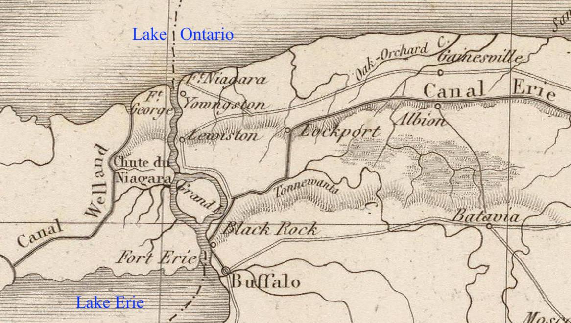
Map detail, showing western New York state, including Ft. Niagara, the Erie Canal, and Buffalo, from Poussin, Guillaume-Tell, Travaux d’ameliorations interieures projetes ou executes par le Gouvernement General des Etats-Unis d’Amerique, de 1824 a 1831 … Atlas. Paris, Anselin, Libraire, pour l’art militaire, les sciences et les arts, […],1834. Imprimerie de Lachevardiere, rue du Colombier, No. 30. Credit, David Rumsey Map Collection, David Rumsey Map Center, Stanford Libraries, non-commercial use permitted under Creative Commons license. Click image to open larger image in new window.1
This week our attention has been turned to New Orleans, the adopted home of Peter Turck’s eldest son—and Mary (Turck) Clark’s younger brother—Joseph R. Turck. Our previous post, J. R. Turck – from Mequon to New Orleans, sketched a brief outline of Joseph’s life, including a half century lived in the Crescent City. That post also discussed Joseph’s very brief service in a Confederate “home guard” militia unit during the Civil War, and how he had lost touch with his Wisconsin family during and after the capture of New Orleans in 1862.
A rare Peter Turck manuscript
We have a number of examples of Peter Turck’s signature—and an occasional bit of text in his hand—from various land documents, marriage licenses, federal census pages, citizen petitions, and other documents from the 1840s to the 1860s. Today’s document is the only letter I have seen in Peter Turck’s own hand, and it gives us a rare insight into Peter Turck’s paternal feelings (as expressed in the typically florid and deferential language of the era) and some additional details about the life of his eldest son, Joseph.1 It’s an interesting letter, and I thought you might like to read it.
Turck’s letter is preserved as part of National Archives and Record Administration (NARA) publication M345, Papers Relating to Citizens, compiled 1861 – 1867. These are letters sent by U.S. civilians to the Provost Marshal’s office of the Union Army. The Provost Marshal was, essentially, the chief of the military police in an area occupied by Union troops.
This letter was published in NARA series M345, microfilm roll 0270, item Joseph R. Turck. It’s accessible online at Fold3.com (pay site). The transcription is mine, and preserves Peter Turck’s occasional curious spelling or punctuation errors. The original letter appears to cover two sides of a single sheet of paper. The original envelope was not microfilmed; it was probably discarded by the New Orlean’s provost marshal’s staff in 1862.
Milwaukee, July 25th 1862
Turck, Peter to Gen. Benjamin F. Butler, July 25, 1862, page 1 of 2. NARA publication M345 Papers Relating to Citizens, compiled 1861 – 1867. Roll 0270, Joseph R. Turck, Fold3.com, accessed 20 March 2014. Click to open larger image in new window.
Once again, several states along and north of the Gulf of Mexico face the force of a major hurricane. As I type this, New Orleans, one of the most historic cities in the United States, is without power, and hundreds of thousands of citizens—and large parts of the the area’s industries and environment—remain threatened as Hurricane Ida makes its way inland. I’ll let other, more knowledgable sources report the news. For now, I encourage you to remember and support our compatriots as they endure and recover from this major natural disaster.
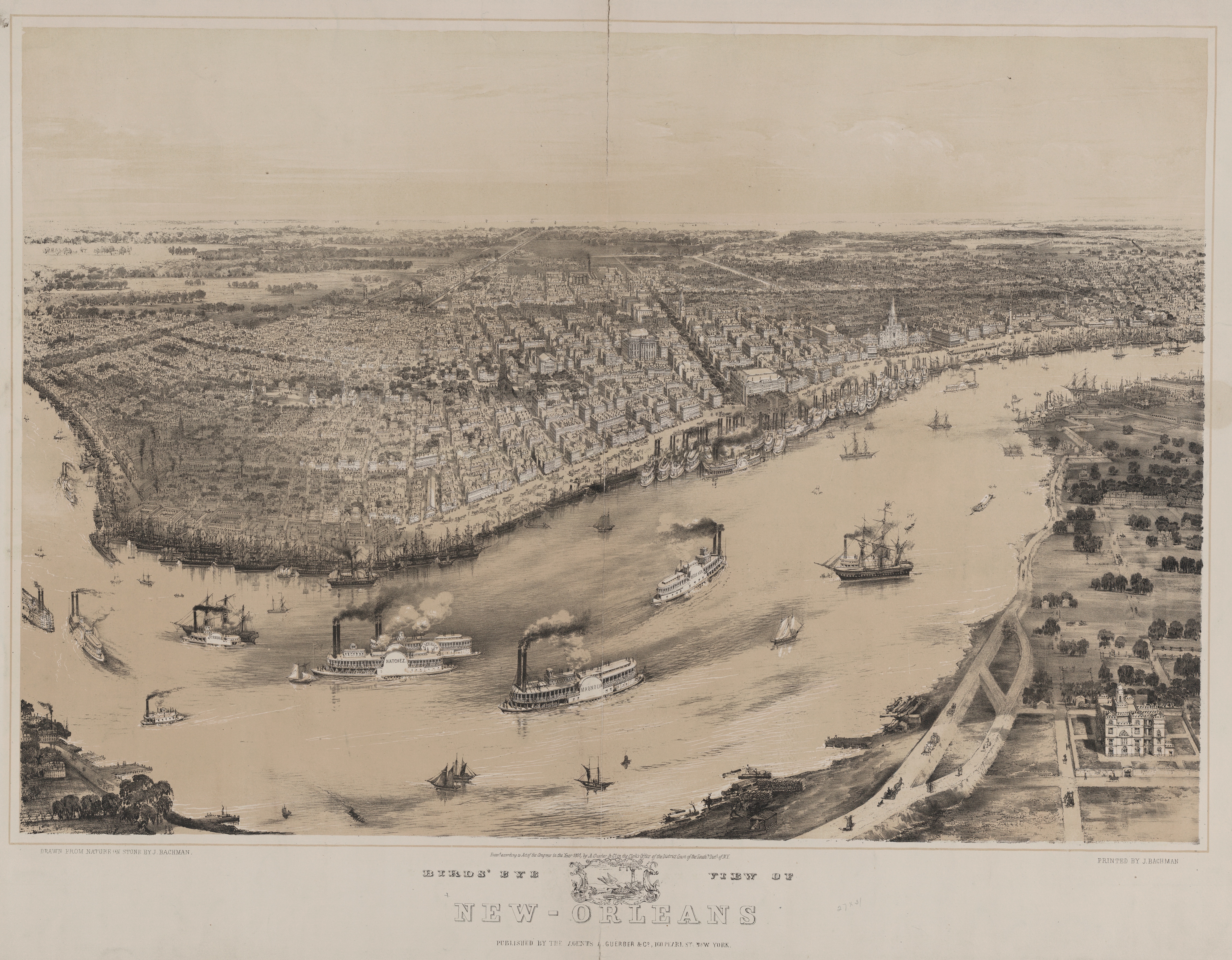
Bachmann, John, Birds’ eye view of New-Orleans / drawn from nature on stone by J. Bachman, [i.e., Bachmann], ca. 1851. New York: Published by the agents A. Guerber & Co., Printed by J. Bachman. Library of Congress. Click to open larger image in new window.
Our series of “How’d they get here?” posts is written to illustrate the nuts and bolts of how our early Mequon pioneers travelled from their original homes or ports of arrival in North America, to the newly opened federal lands in Wisconsin Territory, circa 1830-1850. See Note 1, below, for links to other posts in the series.
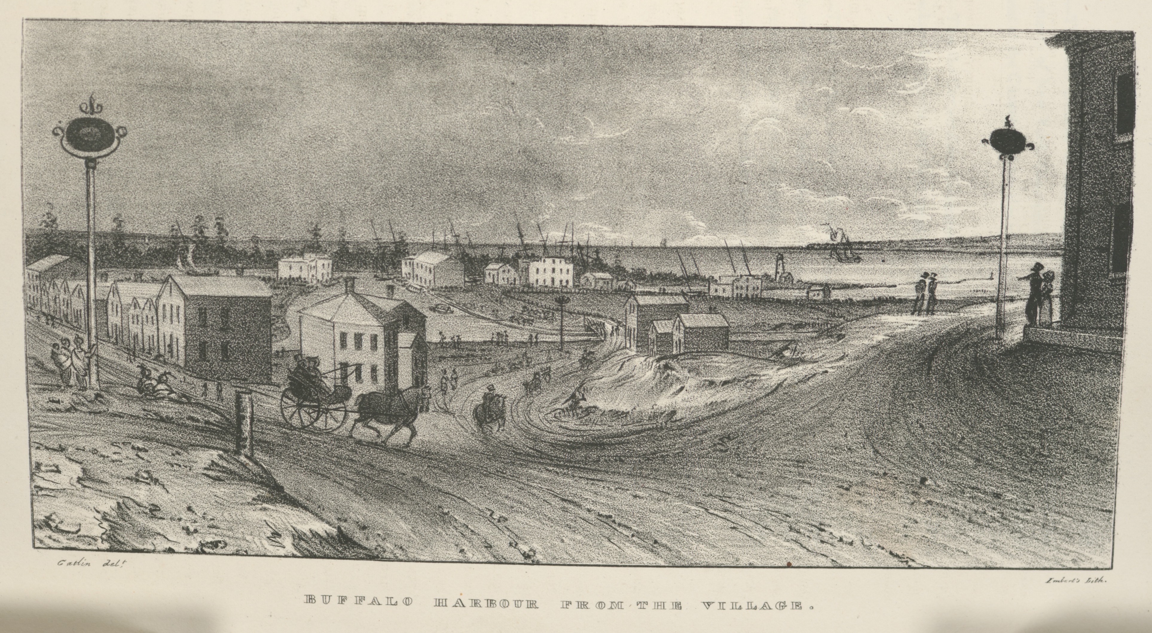
Village of Buffalo, 1825
In a previous post, we followed the newly-opened route for westward migrants from the New York City docks, up the Hudson River to Albany, and then along the new Erie Canal towards its terminus at the village of of Buffalo, New York, at the eastern end of Lake Erie. After seven days of travel on canal boats, the westbound traveler of 1825 would have looked up and seen this, the muddy streets and modest harbor of Buffalo:
Buffalo Harbour from the Village, in Cadwallader Colden, et. al., Memoir…at the Completion of the New York Canals, New York, 1825. Image from “extra-illustrated” edition in New York Public Library Digital Collections, scanned copy of standard edition of book via GoogleBooks. Public domain. Click to open larger image in new window.
After leaving the Deep Cut above Lockport, the last part of the Erie Canal merges with Tonawanda Creek, seen here flowing into the village from far left to center, in front of the line of distant trees, and then curving toward the viewer before exiting into the harbor, to the right. The original Buffalo lighthouse of 1818 can be see on a small peninsula, right of center, just above where Tonawanda Creek meets the lake.
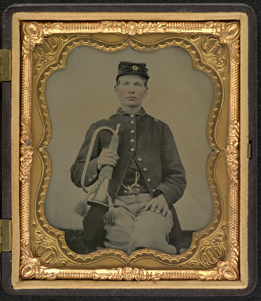
On my way to doing more research on Henry M. Clark’s possible service with the Union army, circa 1863-65, I stopped to re-check some essential resources. One of these is the National Park Service’s Civil War Soldiers and Sailors Database. This is a very useful and handy resource when searching for information on individual soldiers and the histories of the units in which they served.
I thought I’d recheck the service info of some other Mequon-born or -related soldiers, including young Evander B. Bonniwell. As mentioned in earlier posts, Evander Bonniwell (1847-1930), was the son of Clark House neighbors James and Phebe (Capes) Bonniwell. Evander served as a bugler, rank of private, Company I, 2nd Regiment, Wisconsin Cavalry. He enlisted at age 14, and served for four years as company bugler.
[Unidentified soldier in Union uniform with bugle], photographer unknown, United States, c. 1861-1865, Library of Congress. Note: this is not a photograph of Evander B. Bonniwell, but of another young, unknown, Union Army bugler from Evander Bonniwell’s era.
UPDATED, February 11, 2024, to include a revised version of the annotated detail map of Ouisconsin, 1836. But for the full update—with additional notes and corrections—please see the most recent version of our discussion the Ouisconsin map of 1836 on our post of February 12, 2024. UPDATED, July 6, 2021, to answer a reader’s question: “Where was Jonathan Clark just before he went to Fort Howard?” Scroll down to Comments for the answer.
How the early settlers came to Mequon, c. 1835-1850 (part 1)
Clark House education director Margaret Bussone and our education team are putting together a project centered on how our Mequon pioneers traveled to southeast Wisconsin in the early days of white settlement, between roughly 1835 and 1850. I thought I’d help out by gathering some relevant materials and sharing them with the education team—and you—here on the blog.1
So this week we’re going to look at how the settlers found their way here, and how they traveled on land, lake, or river. Rather than writing lots of words about each map or image, I’d like to gather a whole bunch of useful items in each post and put them out there as resources for all to use. Later in the week, we’ll look at various modes of travel on land and on water. Today we’ll look at some maps.2 Some of these maps were readily available to our would-be immigrants, others might have been one-of-a-kind or otherwise hard to obtain.
An overview, The U.S. in 1834
When the following map was published in 1834, Jonathan M. Clark was finishing the first year of his three-year enlistment in the U.S. army. He was stationed at Ft. Howard, on the Green Bay of Lake Michigan, in what was then the civil District of Huron, a soon-to-be-outdated term for the western portion of the Michigan Territory.3
Mequon’s earliest settlers would be coming to lands that were poorly mapped and little understood by most European-Americans. The most this map could show—in a very general way—is where the “open” areas were for future migration and settlement.
Norris, William, and Daniel K Minor. Map of the railroads and canals, finished, unfinished, and in contemplation, in the United States. New York: Railroad Journal, 1834. Map. Library of Congress. Click to open larger map in new window.