UPDATED 16 July 2022, to correct typo in Alfred’s death year. Correct year is 1895.
At last month’s annual meeting of the Friends of the Jonathan Clark House, assistant director Nina Look mentioned that she had some sort of research project coming later this year, involving the youngest Bonniwell brother, Alfred T. Bonniwell (1826-1895). I’m not quite sure what Nina’s project will focus on, but Alfred is, perhaps, the least-known Bonniwell, and deserves further study.
As a Bonniwell brother, Alfred plays his part in the establishment of one of Mequon’s first cleared and populated areas, the Bonniwell Settlement. The Clark house—and Clark family—played an important role in the early decades of this settlement, and the history of the Clark family is intimately tied up with their neighbors, the Bonniwells. How intimately?
Updated February 22, 2022 to fix a few minor typos, and to add a link to a brief history of American samplers, with an illustrated list of 73 of the 137 American samplers in the Textile Collection of the National Museum of American History.
In addition to raising and educating her children, a 19th-century farm wife like Mary Turck Clark had many other responsibilities, including planning and tending a farm garden, preserving its produce, preparing daily meals for the family and hired hands, and keeping the farm house clean and organized. And Mary, like many women of her era, probably made some or all of her own and her family’s clothes.
The sewing arts
Like most girls of her era, Mary Turck (born in New York, 1821) probably learned the craft of needlework from her mother and, perhaps, as part of her school education. When a young girl like Mary mastered some of the many practical and decorative sewing stitches, she might demonstrate her proficiency by making a sampler.
A sampler might feature simple examples of sewn letters, numbers and perhaps a popular saying or Bible verse. But many samplers were more complex and artistic. An accomplished embroiderer might produce an elaborate sampler featuring detailed images and texts, as in this 1829 sampler from Connecticut.
Thompson, Mariette (1817-1851), [Sampler with family register], 1829. Yale Art Gallery, public domain. Click to open larger image in new window.
Updated Feb. 14, 2022 to add the qualifier “English-speaking” to the second paragraph.
Did you watch the Big Game? Go out to eat? Maybe you had to put in a shift at work? Or did you just take a break and relax at home, gearing up for another week on the job? Perhaps you went to church on Sunday.
In Jonathan and Mary Clark’s era, many of their Mequon neighbors would honor the Sabbath by refraining from all work and worshiping privately at home with their families, or gathering with small groups of neighbors to pray and hear the Word. Beginning in the early-1840s, the English-speaking Protestant Christians living near the Clark House—including many members of the Clark, Bonniwell and Turck families—gathered at the new, one-room, Bonniwell School to worship together at Sunday services; these were often led by their neighbor, the farmer and evangelical Methodist preacher Rev. James W. Woodworth.
Rev. Woodworth has concerns…
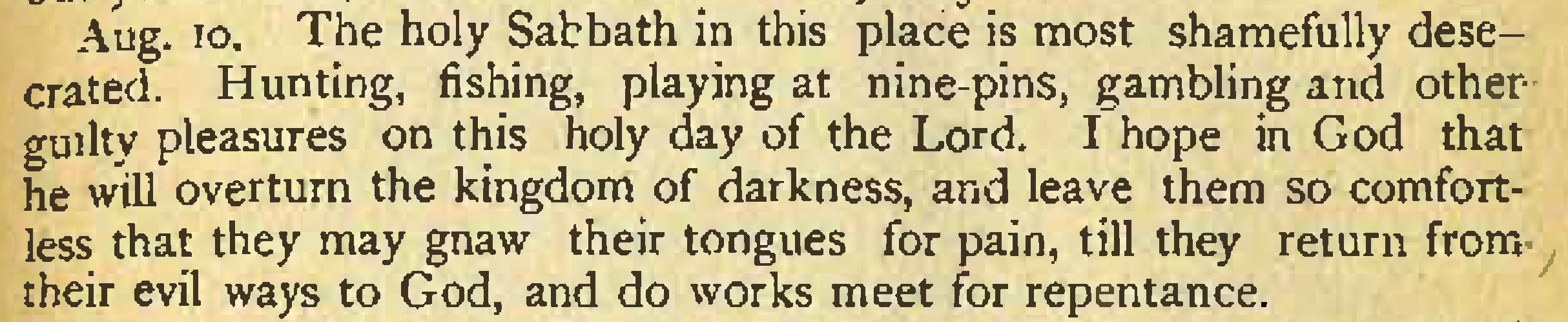
We have talked about Rev. Woodworth previously and, as we have seen before, he was constantly concerned about the state of his neighbors’ souls. It seems that even though the nation was still riding the wave of several decades of the religious revival now known as the Second Great Awakening, the settlers of the young Wisconsin territory and state were not always very good at “keeping the Sabbath holy.” In his diary entry for August 10, 1855, the reverend lamented:
Aug. 10. The holy Sabbath in this place is most shamefully desecrated. Hunting, fishing, playing at nine-pins, gambling and other guilty pleasures on this holy day of the Lord. I hope in God that he will overturn the kingdom of darkness, and leave them so comfortless that they may gnaw their tongues for pain, till they return from- their evil ways to God, and do works meet for repentance.
Woodworth, James W., My path and the way the Lord led me, Milwaukee, 1878, p. 79.
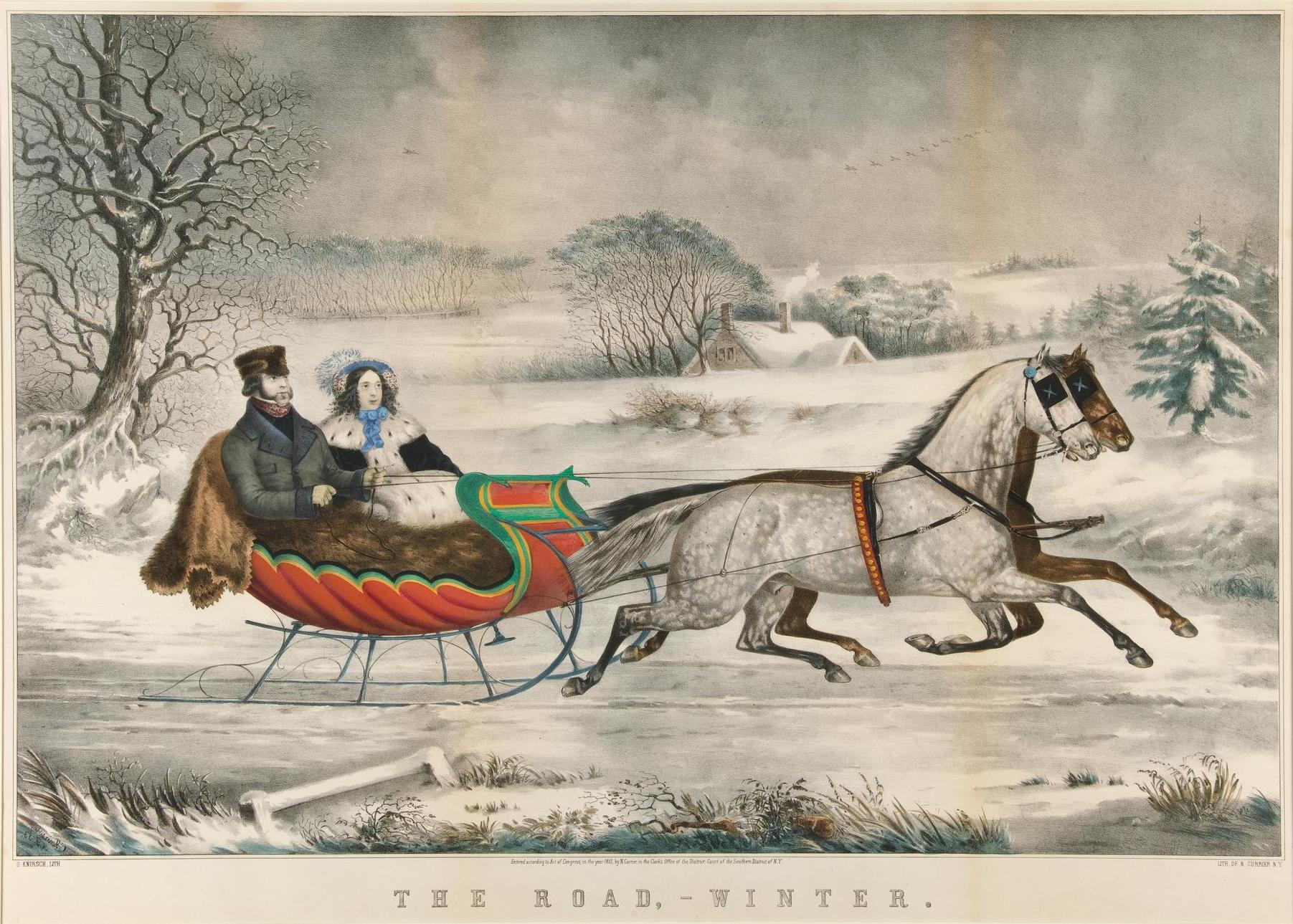
Much of this post appeared last year, but since we—finally!— got some snow in southeast Wisconsin last night, I thought I’d share it again, with a few additions and revisions, and a new, hand-colored, version of the artwork.
Snow, and often lots of it, was a feature of Jonathan and Mary Clark’s life in Wisconsin. So if you wanted to go to town or church or visit your neighbors during the snowy Wisconsin winter—or just enjoy a pleasant winter ride in the country—you’d need a sleigh.
Currier, Nathaniel (1813-1888), The road, winter / O. Knirsch, lith., 1853. New York: Published by Currier & Ives. Yale University Art Museum, Whitney Collections of Sporting Art, given in memory of Harry Payne Whitney (B.A. 1894) and Payne Whitney (B.A. 1898) by Francis P. Garvan (B.A. 1897) June 2, 1932. Public domain. Click to open larger image in new window.1
We don’t know if the Clarks owned a sleigh while they lived in Mequon. I suspect they did, though their sleigh—and their clothing—may not have been quite as posh as those in this Currier & Ives lithograph from 1853.
Tonight is Christmas Eve, and I thought you might enjoy an expanded reprise of our 1867 Santa Claus story, originally posted December 25 and 30, 2017. This year I have combined the two original posts and incorporated some new illustrations and a few revisions of the text. Here it is again, for your holiday enjoyment. Ho! Ho! Ho!
Christmas in early America
For many years now, Christmas has been celebrated by Americans as an important religious and (increasingly secular) community holiday. Christians gather to worship and commemorate the birth of Jesus, and they and other Americans enjoy a break from work to gather with family and friends to feast and exchange gifts. But it was not always this way.
In many of the American colonies, Christmas was not observed as a religious or secular holiday. The seventeenth-century Puritan leaders of the Massachusetts Bay Colony considered Christmas to be non-biblical and pagan influenced. In Boston and other parts of New England any observance of Christmas was prohibited and, for a few years, actually illegal:
Penalty for Keeping Christmas, 1659
Records of the Governor and Company of the Massachusetts Bay in New England. Printed by order of the Legislature, edited by Nathaniel B. Shurtleff, M.D., Vol. IV, Part I, 1650-1660, online at mass.gov (accessed 21 Dec. 2021). Click to open larger image in new window.
Transcription: For preventing disorders arising in several places within this jurisdiction, by reason of some still observing such festivals as were superstitiously kept in other countries, to the great dishonor of God and offence of others, it is therefore ordered by this Court and the authority thereof, that whosoever shall be found observing any such day as Christmas or the like, either by forbearing of labor, feasting, or any other way, upon such accounts as aforesaid, every such person so offending shall pay for every such offence five shillings, as a fine to the country.
Christmas was not generally accepted as a holiday in many parts of the United States until after the federal government made December 25 a national holiday in 1870.
On the other hand…
The Massachusetts Puritans may not have approved of “observing any such day as Christmas or the like, either by forbearing of labor, feasting, or any other way,” but Christmas was “kept in other countries” and increasing numbers of immigrants from those countries to the United States—particularly from Victorian England, Catholic Europe, and the German Lands—celebrated the day in their new American homes with many of their accustomed religious observances and national traditions.
Veterans Day is today. I’m preparing a new post on one of our Clark House veterans, Mary (Turck) Clark’s youngest sibling, Benjamin Turck (1839-1926), but it’s not quite ready yet. For a wider perspective on the day—and our early Mequon veterans—here’s a post originally published at Clark House Historian on November 11, 2016, and revised, expanded and republished on November 11, 2020. I’ve also incorporated a list of Mequon’s Civil War soldiers, originally published here on May 24, 2020.
Armistice Day
One hundred and three years ago, on the eleventh day, of the eleventh month, at the eleventh hour—Paris time—the Armistice of Compiègne took effect, officially ending the fighting on the Western Front and marking the end of World War I, the optimistically named “War to End All Wars.”
In the United States, the commemoration of the war dead and the Allied victory began in 1919 as Armistice Day, by proclamation of President Woodrow Wilson. Congress created Armistice Day as a legal holiday in 1938. Starting in 1945, a World War II veteran named Raymond Weeks proposed that the commemorations of November 11 be expanded to celebrate all veterans, living and dead. In 1954 Congress and President Eisenhower made that idea official, and this is what we commemorate today. There are many veterans with a connection to the Jonathan Clark house. We honor a few of them in this post.
Jonathan Clark, Henry Clark, and the U.S. Army
Jonathan M. Clark (1812-1857) enlisted as a Private in Company K, Fifth Regiment of the U. S. Army, and served at Ft. Howard, Michigan (later Wisconsin) Territory, from 1833 until mustering out, as Sargent Jonathan M. Clark, in 1836. In the 1830s, Fort Howard was on the nation’s northwestern frontier. JMC’s Co. K spent much of the summers of 1835 and 1836 cutting the military road across Wisconsin, from Ft. Howard toward Ft. Winnebago, near modern Portage, Wisconsin.
Fort Howard, Wisconsin Territory, circa 1855, from Marryat, Frederick, and State Historical Society Of Wisconsin. “An English officer’s description of Wisconsin in 1837.” Madison: Democrat Printing Company, State Printers, 1898. Library of Congress. Click to open larger image in new window.
In a recent post, Caroline Clark – public school teacher, we examined Caroline Clark’s brief tenure as a teacher in the grammar department of Milwaukee’s Ninth Ward School, and concluded:
Caroline Clark’s employment as a Grammar Department teacher began on September 1, 1860. According to the 1861 Report, she taught for eight months. That would mean she left her teaching position around the beginning of May, 1861. Why? One factor might have been her salary […] But the more likely reason for her departure from the Ninth Ward School was that on May 15, 1861, she married Milwaukee county farmer William Wallace Woodward. For much (all?) of the nineteenth century, it was customary for female school teachers to be single; once they married, they were expected to leave the profession and set up housekeeping with their new husband and, eventually, start a family of their own. I think it’s safe to assume that this is what happened to “Miss Caroline M. Clark” in May, 1861.
Finding Caroline’s marriage record
Long before I found Caroline’s 1893 biographical sketch, or her profile and interview in the OmahaDaily Bee (March 30, 1916, page 11), or read her several long obituaries, I was able to determine when—and whom—she married. How? By using the Wisconsin Historical Society’s invaluable—but not infallible—Pre-1907 Vital Records Database (Birth, Marriage, Death). Yes, the interface is a bit clunky, but if you search for “Clark, Caroline,” one of the results you’ll find is:
Seems plausible, right? But how do we know it’s “our” Caroline? And how do we match her with a spouse?
Today, as we continue to explore the life of Jonathan M. and Mary (Turck) Clark’s eldest child, Caroline Mary Clark—later usually known as Mrs. C. M. Woodward—we’ll take a fact-by-fact look at the biographical sketch of Caroline that was published in 1893, re-printed unchanged in 1897, then abridged and reprinted in 1912. For a full discussion of these three publications, see last Monday’s Caroline M. (Clark) Woodward: first steps toward a biography.
Willard, Frances E., and Mary A. Livermore. 1893. A woman of the century ; fourteen hundred-seventy biographical sketches accompanied by portraits of leading American women in all walks of life ; ed. by Frances E. Willard and Mary A. Livermore, assisted by a corps of able contributors, title page and page 779.
Today’s post will be less of a fully-formed essay, and more of a running analysis, commentary, and proof-reading of this 1893 biographical sketch. We’ll take one portion at at time, starting at the beginning. The source text will be presented as a shaded quotation, followed by my commentary and corrections in simple black text on white background, with highlighted links to additional sources and explanations and, of course, a few footnotes, too. Here we go…
In our most recent blog post, Another family portrait! Caroline (Clark) Woodward, c. 1890s, we located and discussed the history of a previously unknown photo of Jonathan M. and Mary (Turck) Clark’s eldest child, Caroline Mary Clark, later usually known as Mrs. C. M. Woodward:
Townsend Elite Studio, [Portrait, Caroline M. (Clark) Woodward], inscribed “Mrs. C. M. Woodward, Supt. Work among Railroad Employes, N.W.C.T.U.”, photograph, circa 1889-1900. Photo courtesy Frances Willard House Museum & WCTU Archives, Evanston, Illinois. Click to open larger image in new window.
Caroline’s life was the most public—and perhaps best documented—of all the members of Jonathan M. Clark family, and is overdue for a closer examination. So today we begin a multi-part look at Caroline’s story, starting with three biographical sketches that were published during her lifetime.
UPDATED, Oct. 4, 2021, with a few minor edits and to add an additional footnote.
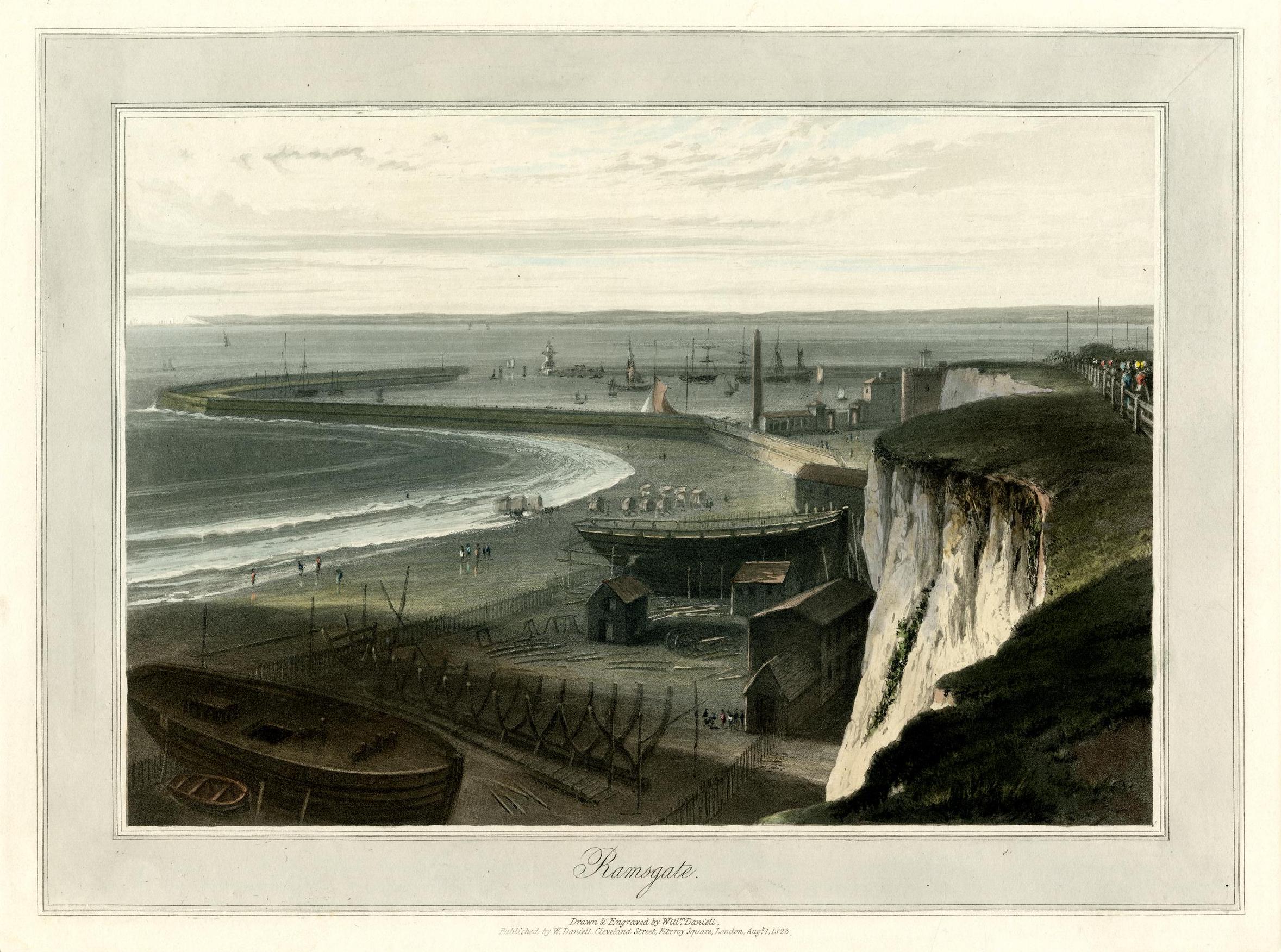
I’m still working on some longer posts; they should be ready soon. Meanwhile, I thought you might enjoy two lovely images, beginning with this nineteenth-century print, a view that would have been very familiar to a surprising number of our early Mequon immigrants: