Did you know that in the early days of settlement, much of Cedarburg—and a surprising portion of Mequon—was home to Irish immigrants? Come by the Jonathan Clark House Museum on Saturday and find out if your home had Irish neighbors! Come look at historical maps while you nibble on house made butter and Irish soda bread and enjoy festive music on the Celtic Harp. Event co-sponsored by the Cedarburg History Museum.
The museum is located at the corner of Bonniwell and Cedarburg roads in Mequon, Wisconsin. We look forward to seeing you on Saturday! And as St. Patrick’s Day approaches, you might be interested in catching up on some previous, Irish-themed Clark House Historian posts. Just read on, click all the links, and Erin go Bragh!
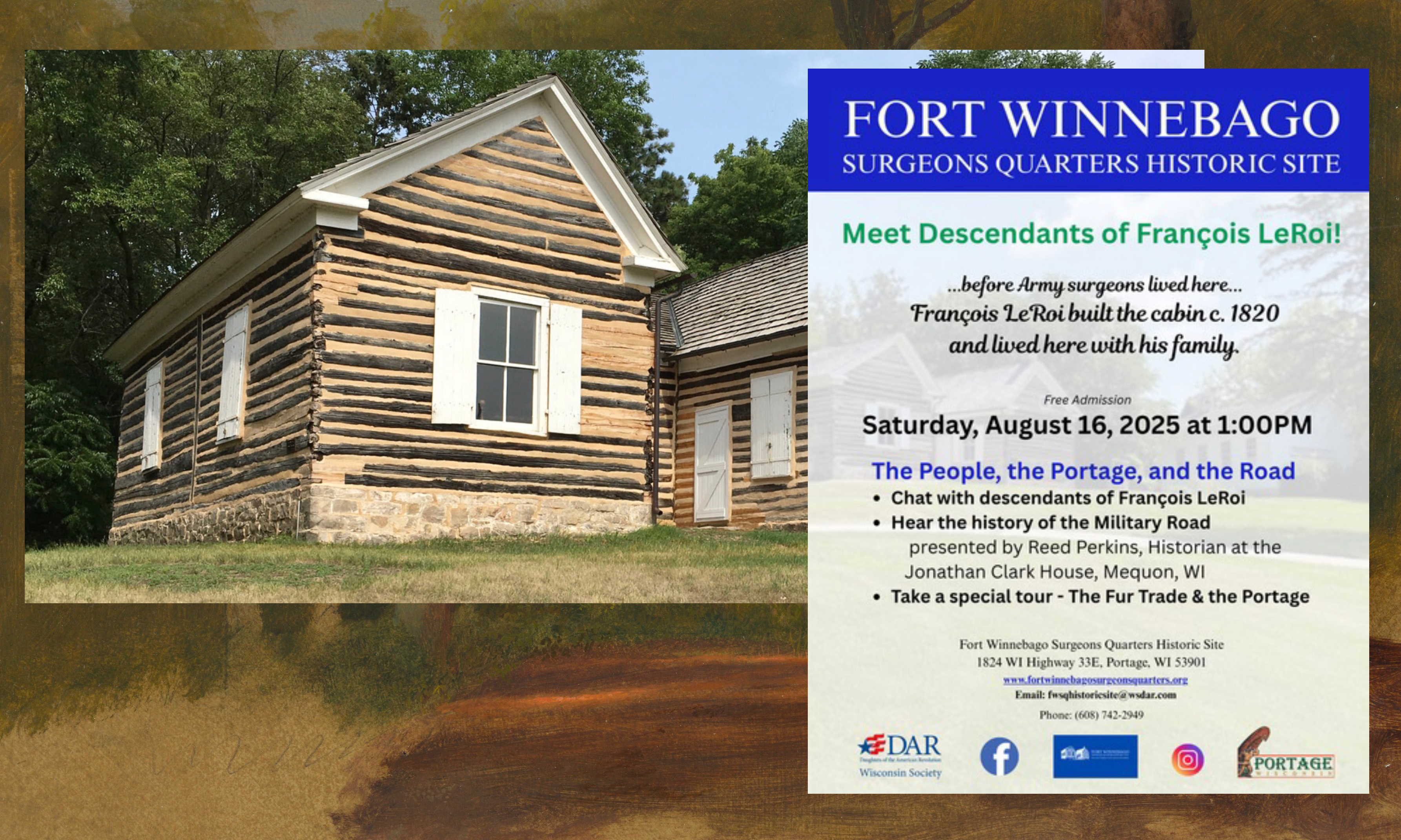
In a recent CHH post I wrote about my Saturday, August 16 visit to, and presentation at, the WSDAR’s excellent Fort Winnebago Surgeons Quarters historic site. That was worth a road trip in itself. But since I was heading up to Portage, I decided to make a history weekend out of the occasion. So on Friday the 15th, I spent a fine few hours touring the nearby Historic Indian Agency House and museum, just a short distance from the Surgeon’s Quarters across the old channel of the Fox River.
Historic Indian Agency House, 2025. Photo credit: Reed Perkins
The Historic Indian Agency House
The Historic Indian Agency House (HIAH) is one of Wisconsin’s oldest museums and a “must see”, for those of you interested in the early days of the Wisconsin Territory and the history of the state’s original Native American inhabitants and their forced removal during white settlement in the 1820s, ’30s and beyond. Like the nearby Fort Winnebago and its remaining Surgeon’s Quarters, the story of the HIAH overlaps and intersects with the story of Jonathan M. Clark and his 1833-1836 military service at Fort Winnebago’s headquarters post, Fort Howard, in Green Bay.
It’s been a while, I know! One thing led to another and this summer ended up being a very quiet summer here on the CHH blog, with just a post or two over the past few months. My apologies to you all. However, I have been very busy “behind the scenes,” reading, researching and writing all summer long, and I have lots of new historical information and stories to share with you.
Fort Winnebago Surgeons Quarters—and more
One of the projects that has kept me busy this summer was researching and preparing a presentation that I gave last Saturday, at the historic Fort Winnebago Surgeons Quarters museum as part of their The People, the Portage and the Road event. Originally, my talk was going to be a lightly-revised update of my September, 2024 talk at the Wisconsin Society of the Daughters of the American Revolution’s Fall Workshop in Oshkosh.
That talk, “Building the Military Road,” contained about 45 minutes of detailed information about Wisconsin’s first federal road, and the men that built it—including our own Sgt. Jonathan M. Clark—tightly squeezed into about a half-hour time slot. The presentation was well-received, and I was invited to repeat that talk at this August, 2025, event at the WSDAR’s Fort Winnebago Surgeons Quarters museum in Portage.
However! The August 16th event was also going to be a reunion of the descendants of François LeRoi (aka Francis LeRoy or Roy)—the man that first built and occupied the historic surgeon’s quarters (1816-1829), and it was suggested that I include some Francis LeRoy related information in my talk, a very reasonable request. Since I already knew quite a bit about the Military Road, the Portage, and the life and times at Forts Howard and Winnebago in the 1830s, I thought I would just need to make a few minor cuts to my original talk, find a few, possibly obscure or unknown, LeRoi documents, add them to the presentation and, well, that would be just the thing! Well…
Just a reminder: Saturday, March 1, 2025, from 9:00 am to Noon, the Jonathan Clark House Museum, at the corner of Bonniwell and Cedarburg Roads in Mequon, will host a special museum open house featuring an up-close exploration of our newly-acquired 1860 Plat Map of Mequon.
Saturday, March 1, 2025, from 9:00 am to Noon, the Jonathan Clark House Museum, at the corner of Bonniwell and Cedarburg Roads in Mequon, will host a special museum open house featuring an up-close exploration of our newly-acquired 1860 Plat Map of Mequon.
Updated, August 4, 2024, to add a few explanatory links, to clarify the years of arrival of B. Clow and D. Maxon, and to clarify which families stayed in Washington/Ozaukee county, and which sold out and moved on.
Home away from home
Until the late-1850s, there were no railroads connecting Mequon to Milwaukee. If you needed to go to the city—for shopping, shipping, social calls or legal business—you either had to ride a horse, a wagon, a carriage (a sleigh in the winter), or simply walk there and back. It was about a 19 mile journey, over roads of dubious quality and variable states of repair. Even in fine weather, a one way trip might take the better part of the day.
So it was not unusual for Mequon farmers, such as the Clarks and their neighbors, to need a place to stay overnight when they ventured to the city. And from early days, one of the top destinations for Milwaukee travelers was the American House hotel. In 1844, the American House looked like this…
Advertisement, “American House,” [Prairieville (later Waukesha), Wisconsin] American Freeman, 28 Sept 1844 p 4
Take a moment to click the image and open a larger version in a new window. Zoom in and admire the couples strolling on the balconies and the arriving, or departing, stagecoach at the front door. All in all this looks pretty deluxe, by 1840s’ standards. But the hotel business, then as now, was always changing. Less than six years later the American House would be expanded, refurnished, and under new management…
I’m working on several substantial and related posts centered around maps and documents that describe the early settlement of Stanstead Township, Lower Canada, from about 1791 to 1810. There are several Clark families involved, and I am investigating whether any of these early Stanstead Clarks might be kin to our Jonathan M. Clark. Research is going along well enough, but the writing is taking more time than planned.
But I couldn’t let this Monday pass without sharing a special map with you, one that I came across while searching for more relevant maps in the digital collections of the Library and Archives Canada (LAC) website. Today’s map is, I believe, the earliest map of what would eventually become the Eastern Township of Stanstead, Lower Canada.
The Search for JMC’s roots continues!1 For the last few months, I’ve spent hour after hour reading through hundreds of digitized pages of the various manuscript land petitions and related documents that form the Land Petitions of Lower Canada, 1764-1841 database at Library and Archives of Canada (LAC).2
The good news is that I have found a lot of information about various early Clark (or Clarke) surname immigrants that petitioned for land—and actually settled on it—in Lower Canada during the relevant years of circa 1791-1840. Many of the documents that I’ve found contain information about these Clark immigrants, their families, and from whence they come. This is important, as we need to sort the Patriot, Vermont-related Clark families from other Clark immigrants from New York and New England (including American Loyalists), and the various Anglo-Canadian Clark families that sought land in the Eastern Townships at the same time. So, you know what that means…
We need another map!
Now that we have all this data, we need a way to organize and present it. And since so many of our rejected candidates earn their “Nope, not our Clark family” status because they settled far away from Stanstead, I thought it was time to make a big map of where these various Clark petitioners for Lower Canada land actually ended up. Then, in theory, we can eliminate the Clark families that settled “too far” from Stanstead (and adjacent Derby, Vermont), and focus on the Clarks that settled in or near Stanstead itself.
It’s going to take a while to assemble and present all the data. So we need a big,easy to read map created around the time of Jonathan Clark’s childhood and/or youth, from about 1812 until his arrival in New York state in 1831. (The latter date is flexible, as long as we find a map that predates the reorganization of the townships into larger counties in 1847.) We’ve presented some great Lower Canada maps here at CHH but, as is typical of that era, if they are accurate and detailed, they also tend to be visually “busy” and hard to read. But, dear readers, I finally found just the thing…
I spent much of January and February preparing my March 9th, 2024, Civil War presentation at the Cedarburg History Museum. In that talk I tried to take a more personal and local look at the war by examining the military service of few of the Cedarburg relatives and future in-laws of 1868-1873 Clark House resident Fred Beckmann. In my research, I found some unique stories of their years of Union service in the 9th and 26th Wisconsin Infantry Regiments, as well as the impact of the war on families and friends back home in Wisconsin.
I also found several new online collections of unique maps and historical documents. Today’s map is from one of those online sources, the digitized map collection of the National Archives and Records Administration (more on NARA and its holdings, below). This map was made 20 years before the Civil War, in September, 1840, and is one of the earliest—if not the earliest—maps of the federal roads in Wisconsin Territory.1
Today’s Monday: Map Day! revisits and makes a correction to an interesting map that we first discussed here on October 29, 2017, and then re-visited on July 11, 2020. And for unknown reasons, that original 2017 post—according to my monthly WordPress statistics report—was the most-viewed post on this site for the month of January, 2024, with 341 views (!).
Burr, David H. Map of the Northern Parts of Ohio, Indiana and Illinois and Michigan and that part of the Ouisconsin Territory lying East of the Mississippi River, 1836, detail of title & author. Library of Congress.
The 2020 re-post was originally conceived as a kind of addendum to our June-July, 2020, multi-part discussion of the earliest Wisconsin territorial, state, and federal censuses. It also served to locate Jonathan M. Clark in Wisconsin Territory during his U.S. Army service from September, 1833, to September 19, 1836.
Today’s post includes one particular correction that I’ve been meaning to make for a while. When I added my original annotations to a detail of this map (in red), in 2017, I made an error. I mislabeled Sgt. Jonathan M. Clark’s location at the time he mustered out of service, a temporary army camp along the under-construction military road from Fort Howard (Green Bay) to Fort Winnebag0 (Portage). JMC’s muster-out location was always referred to in the records of the Fifth Regiment of Infantry as “Camp Hamilton.” For some reason, when I made my annotated detail map, I incorrectly labeled this place “Ft. Hamilton.” A minor error, but worth correcting , especially now that this map is receiving fresh attention.1
It’s 1836. Where’s…Wisconsin?
In September, 1836, Sgt. Jonathan M. Clark was discharged from the U.S. Army at “Camp Hamilton,” Wisconsin Territory, after serving his three-year term of service with Co. K, Fifth Regiment of Infantry.2 One year later, in the autumn of 1837, Jonathan’s future wife Mary Turck would make the long trip from Palmyra, New York, to Milwaukee and finally Mequon, Washington County, Wisconsin, with her parents Peter and Rachael Turck and six younger siblings. By the end of 1840 Jonathan and Mary would be married and starting their family in Mequon.
That seems simple enough, until you take a moment to wonder how much Jonathan—or especially Mary and her family—knew about this new Wisconsin Territory. Jonathan had been in the territory since October, 1833, mostly on post at Ft. Howard. In the last year or so of his service he was busy cutting trees and building bridges for the military road along the Fox River waterway from Ft. Howard (Green Bay) towards Ft. Winnebago (near modern Portage). As a road-building soldier, Jonathan might have done some surveying and seen—or helped draw—a variety of maps of the military road and its vicinity. But for a better overview of this new territory, Jonathan or Mary might have sought out a map such as this: