I found Bouchette’s 1815 Topographical Map of Lower Canada…
In our previous post, we looked at a verbal description of Stanstead, Lower Canada, excerpted from A Topographical Description of the Province of Lower Canada, with Remarks upon Upper Canada, and on the relative connexion of both provinces with the United States of America, written by Joseph Bouchette, surveyor general of Lower Canada, and published in London in 1815.
To accompany his 1815 book, Bouchette published a map of the province, and it’s an amazing map, with an extravagant title:
To His Royal Highness George Augustus Frederick … This Topographical map of the Province of Lower Canada, shewing its division into Districts, Counties, Seigniories, & Townships … Is … Most gratefully dedicated by… Joseph Bouchette, His Majesty’s Surveyor General of the Province & Lieutt. Colonel C.M. … Published by W. Faden, Charing Cross, Augst. 12th. 1815. Engraved by J. Walker & Sons, 47 Bernard Street, Russell Square, London. J. Walker sculp.
Rumsey Collection
For simplicity’s sake, I’ll refer to it as Bouchette’s Topographical map of the Province of Lower Canada, 1815. The original is held in the vast David Rumsey Map Collection at Stanford University. And in the words of their curators,
[t]he large ten sheet map is extraordinary – it is over ten feet long when joined and almost five feet tall. It has five views and three large inset maps of Montreal, Quebec, and Three Rivers. The detail and graphic elegance of the large map is the equal (or perhaps the superior) of any of the contemporary maps that we have seen (and none of which are on such a large scale – the only potential candidate would be Eddy’s Map of the Country Thirty Miles Round the City of New York). Of course the engraving was done by the Walker firm in London, whose resources were up to the New York and Philadelphia engravers, or better, so a comparison with American produced maps is not entirely fair. Bouchette’s work as Surveyor General must have instilled in him an obsession with the accuracy and fineness of detail that one sees in these maps.
Rumsey Collection
So enough fanfare. Let’s look at the map:

Bouchette, Joseph, Topographical map of the Province of Lower Canada, 1815. Credit, David Rumsey Map Collection, David Rumsey Map Center, Stanford Libraries, non-commercial use permitted under Creative Commons license.
I always suggest that you “click to open larger image in a new window.” Perhaps you don’t always do that. This map really must be enlarged to use and enjoy. So go ahead, find a big screen if you have one, and click to open the full-size map in a new window—tap again to enlarge, if you need—and then zoom and scroll around to see the layers and layers of details.
To help get you oriented, here’s the full map–again in high resolution—with a few annotations added (click this one, too):

Bouchette, Joseph, Topographical map of the Province of Lower Canada, 1815, annotations by Reed Perkins. Credit, David Rumsey Map Collection, David Rumsey Map Center, Stanford Libraries, non-commercial use permitted under Creative Commons license.
North is not at the top
The first thing to note is that the map is not oriented with north at the top. Since the actual province of Lower Canada is aligned along the St. Lawrence River as it flows in a generally southwest-to-northeast direction, surveyor Bouchette “tilted” the map so the river runs generally west-to-east, left-to-right. This allows the maximum amount of Lower Canada topographical information to fit onto the pages of the original atlas. For orientation, there are several compass roses on various section of the map; I have highlighted one in the upper right corner with red arrows and a big red “N” for your convenience.
Borders, and more, in color
The international border between the USA and Lower Canada was hand-colored in yellow on the original map. The borders of the Lower Canada judicial districts of Montreal, Trois Rivieres and Quebec were also hand-colored, in red. Along with the red compass rose and “N,” my annotations are in blue letters, and I added a light green border to two sides of the township of Stanstead (more on that below).
The key to the map
R. — indicates the map’s “References, ” or key. It’s always worth checking a map’s key. Some symbols or lines carry different meanings on different maps. And some maps show an unusual amount of information and detail. This map is one of the latter. Just to make life easier, here’s a copy of the key:
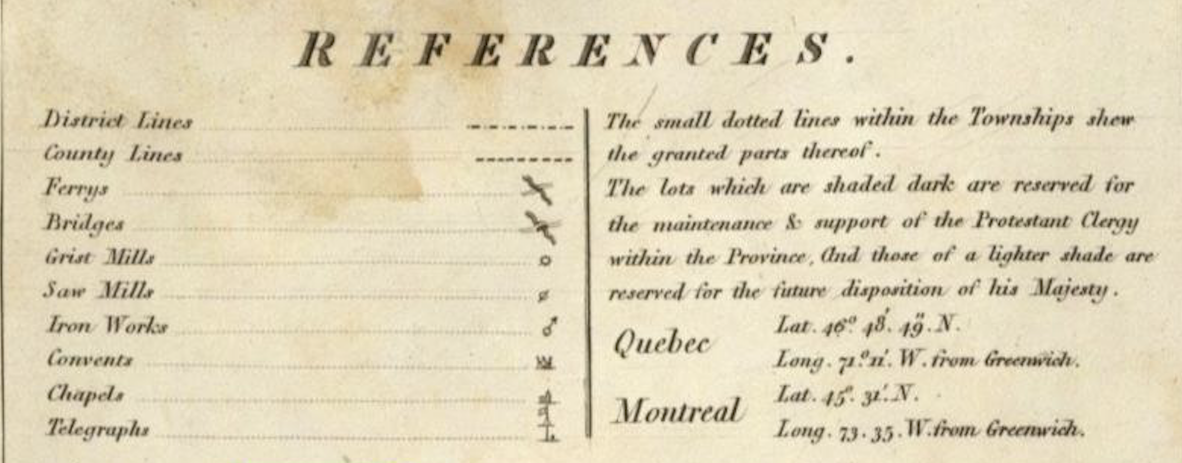
Bouchette, Joseph, Topographical map of the Province of Lower Canada, 1815, detail Credit, David Rumsey Map Collection, David Rumsey Map Center, Stanford Libraries, non-commercial use permitted under Creative Commons license.
The items on the left side of the key are useful and more detailed than in many contemporary maps, especially maps that cover an entire state or province. But it’s the information explained in the paragraph on the right side of the References that will prove extremely useful to us in the future. More on that in coming posts.
The cartouche:
C. — This indicates the map’s cartouche. A cartouche is the place where the title of the map and name of the mapmaker may be found. Sometimes the cartouche is small and simple. Other times—such as this map—the cartouche is a lavishly illustrated affair. It’s well worth your time to zoom in on this one. It includes a riverside view of, I believe, Quebec City, and some fanciful other images, including an indigenous or Metis couple and their home, and a large waterfall.
Lower Canada’s neighbors
There are three American states, and one future state, indicated on the map:
NY — State of New York
VT — State of Vermont
NH — State of New Hampshire
ME — Province of Maine (part of Massachusetts until statehood in 1820)
City, town and navigation details
There are three inset maps showing details of the three major population centers in Lower Canada:
M. — Town of Montreal
T. — Town of Trois Rivieres
Q. — City of Quebec
V. — There are also five Views inset in the upper-right corner of the map. These show some important navigational locations—mostly islands and promintories—as seen from the water, with information for safe navigation of some these places.
Derby and Stanstead
D. — the blue arrow here points to the township of Derby, Orleans county, Vermont, one of the two supposed birthplaces of Jonathan M. Clark. Derby township is rectangular and indicated, like all the townships on the map, in small all-caps: DERBY. The western border of Derby township is the shore of the south end of Lake Memphremagog
If you look closely, just below the “A” in STATES (along the U.S. side of the the U.S.– Lower Canada border), you’ll see the word Derby in smaller type. This is the location of the village usually known as Derby Line. And just north of the township of Derby and village of Derby Line is the Lower Canada township of Stanstead.
S. — The blue arrow here points to the Lower Canada township of Stanstead, the other supposed birthplace of Jonathan M. Clark. I’ve highlighted the township’s northern and eastern boundary lines in light green. The western boundary is Lake Memphremagog and the southern boundary is the international border.
If you zoom in close, you’ll see the small rectangles of the individual lots that have been surveyed and have been, or will be granted by the Crown to individual settlers. We’ll have much more to say about this, but for starters, note the grid system here. It’s generally similar to the Township and Range system we use in the U.S., but with some differences that we will discuss in future posts.
In Canada, land is partitioned into ranges and lots. On this map, Stanstead township has 14 ranges arranged in north-south columns. Range 1 is on the shore of Lake Memphremagog; range 14 is adjacent to the border with the township of Barnston.
Each range is divided into rectangular lots. The ranges of Stanstead are divided into 29 lots per range. Lots numbered 1 are at the south, on the international border. The lot numbers ascend as you go northward. Lots numbered 29 are along the north edge of the township, adjacent to the township of Hatley.
Don’t ignore Vermont!
One other nice feature of this map is its depiction of Vermont. All the townships are clearly labeled, and we have a decent picture of the towns, terrain, major waterways and the (few) important roads.
As our search for Jonathan M. Clark’s roots will zig-zag back and forth between Vermont and Lower Canada, you may find it handy to bookmark this post for easy reference to this remarkable example of the mapmaker’s art and science.
In upcoming posts we’ll zoom in on Stanstead and start to locate the various Clarks and their friends that received land grants from the Crown in the years 1800-1830 or so.
––––––––––––––––––––
Regular readers know that I like to salute libraries, archives, and other institutions that preserve our history and cultural memory and make their resources available to the public for research, education, and enjoyment. Today’s post would not be possible without the glorious and generous resources of the David Rumsey Map Collection. If you have any interest in history and maps, charts, globes, atlases, and such, go to their elegant website and marvel the more than 100,000 maps in the collection.
And by the way. I have uploaded the largest possible, highest-resolution, JPEG of this map to my WordPress media library. If you enlarge the map from this blog post you will get excellent resolution and detail. There are much larger JP2000 and TIFF versions available for download at the Rumsey Collection, but these require special software to view. You can view the map at its highest resolution on the website, just click this link, zoom in all the way, and give a tip of the hat to Joseph Bouchette and his surveyors, engravers and printers.

Pingback: Monday: Map Day! | Clark House Historian
Pingback: Monday: Map Day! | Clark House Historian
Pingback: Leaders and Associates – the unique land grant system of early Lower Canada | Clark House Historian
Pingback: Monday: Map Day! | Clark House Historian
Pingback: Monday: Map Day! | Clark House Historian