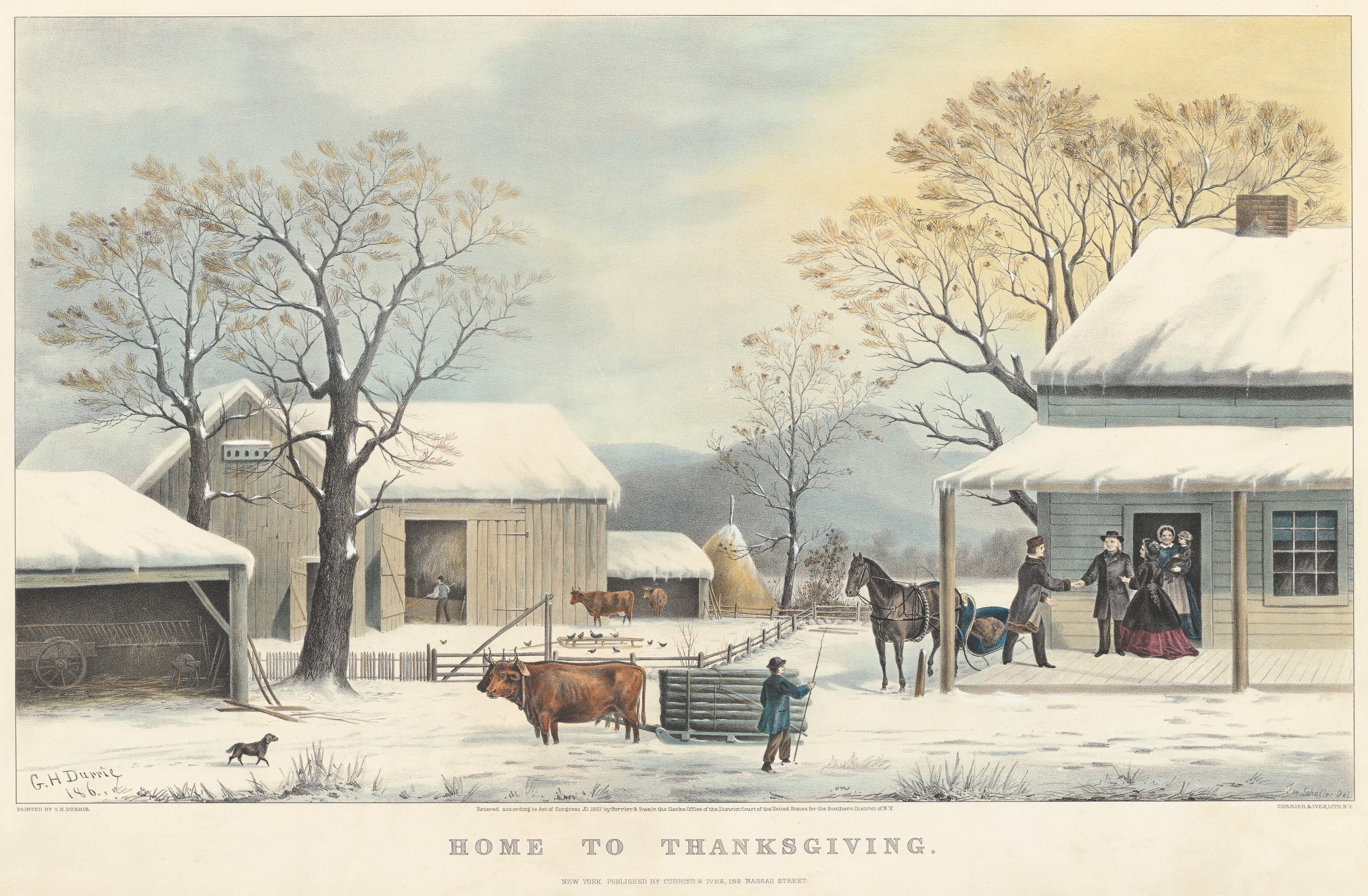
It’s Thanksgiving today, and I’m taking a few days off to spend time with family. But in the spirit of the holiday, I thought I’d reprint a lightly revised version of our now-annual Thanksgiving post, to share with you a few vintage recipes and a nice Currier & Ives lithograph from the period.1
Thanksgiving, 1867
Durrie, George H. and John Schutler, Home to Thanksgiving, ca. 1867, New York, Currier & Ives. National Gallery of Art, Collection of Mr. and Mrs. Paul Mellon. Public Domain. Click to to open larger image in a new window.
The Clark House Historian at his desk, wondering where October went…1
It’s been over a month since our last Clark House Historian post! Sorry about that. It’s not that I haven’t been busy with JCH writing and organizing. I have been. But most of my work for the last month has been done behind the scenes as the Jonathan Clark House graphic designer and webmaster.
For a good roundup of what’s been going on, please head over to our JCH official website and click on the News & Events page for details.
I’m getting back into the blogging groove, and one of my first projects is to continue our series “Not our Jonathan: other “J. M. Clarks” in 1830s & ’40s Wisconsin.” And in my research for that, I’m looking into the identities of one or more men named “J. M. Clark” that served as chaplain at the 5th Regiment’s post at Fort Winnebago.
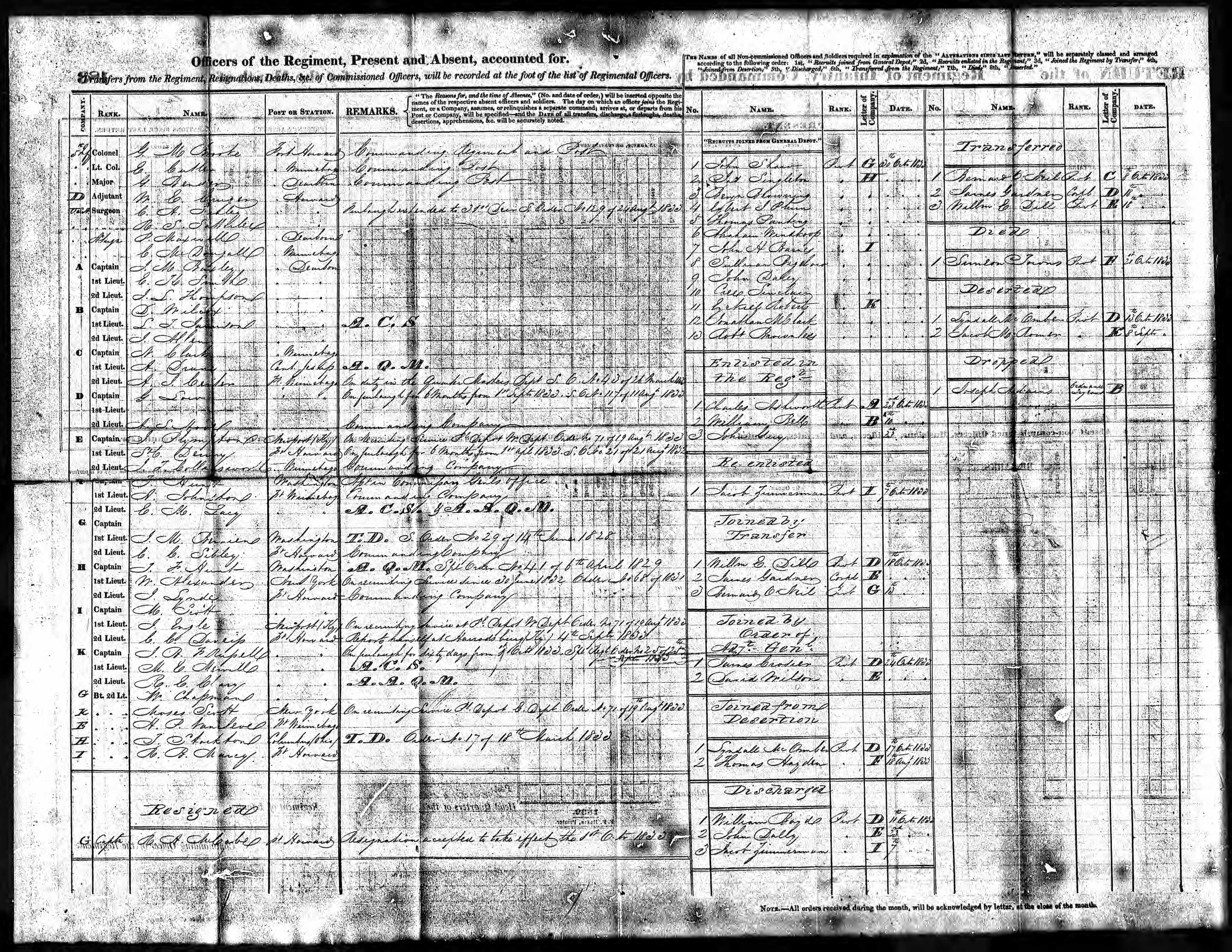
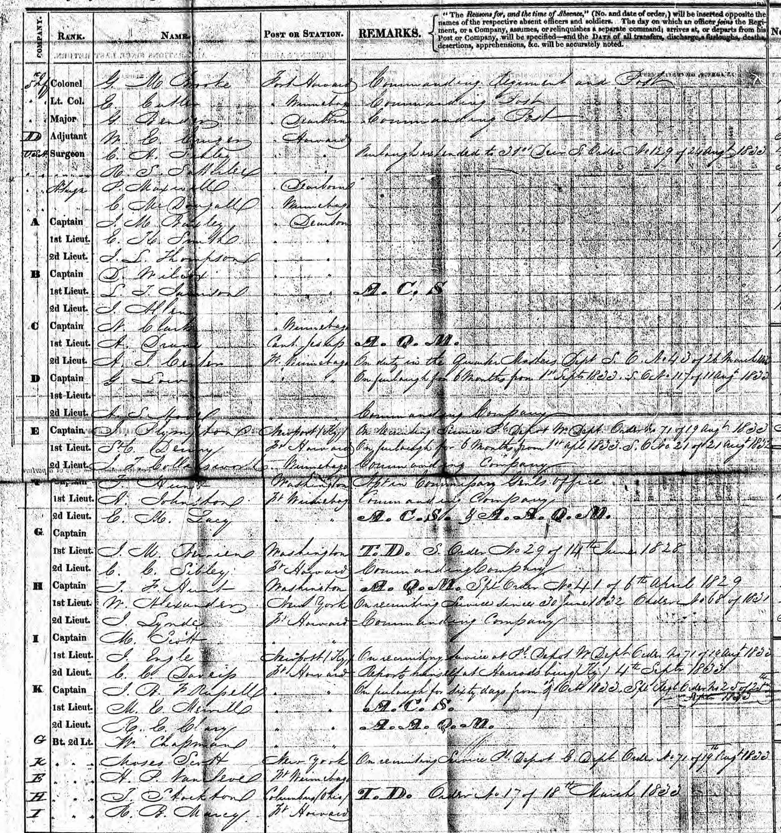
An important primary source for this research are the monthly “Returns” or reports, sent from the 5th Regiment’s posts at Forts Howard and Winnebago back to the army’s chief bureaucrat, the Adjutant General, in Washington, D.C. We’ve examined these Returns several times on Clark House Historian, including this post from 2016 which discussed this October, 1833, bit of U.S. Army record-keeping, the Return of the Regiment [for the 5th Regiment Infantry, at Fort Howard], October, 1833, verso:
NARA, Washington, D.C.; Returns from Regular Army Infantry Regiments, June 1821 – December 1916; Microfilm Serial: M665; Roll: 54 Military Year : 1832-1842. Return of the Regiment [for the 5th Regiment Infantry, at Fort Howard], October, 1833, verso, from Ancestry.com (pay site).
What’s that name???
For our purposes, one of the most useful features of these monthly Returns is the top left section of the form, which lists the officers of the regiment by [Company], Rank, Name, Post or Station, and with a space for Remarks about their assignments, temporary duty, leaves of absence, and so on. There’s a lot of useful information here, especially the names of the officers and the companies that they lead. But click the image to open a larger version of this image, and see if you can actually read those names:
On the one hand, the regimental clerk that filled out this October, 1833, form had pretty tidy penmanship, and the digitized microfilm image is not too bad. But even so, some of the names are hard to decipher. And knowing these names can be really useful, for example when looking for correspondence between these regimental officers and the Adjutant General’s office in D.C. (See our post here, for more on this archive.)
So how do we learn “Who’s Who” on the monthly “Returns from Post” and “Returns of the Regiment”? Fortunately, the government put all that info into a series of very useful books, which are now available, for free, online…
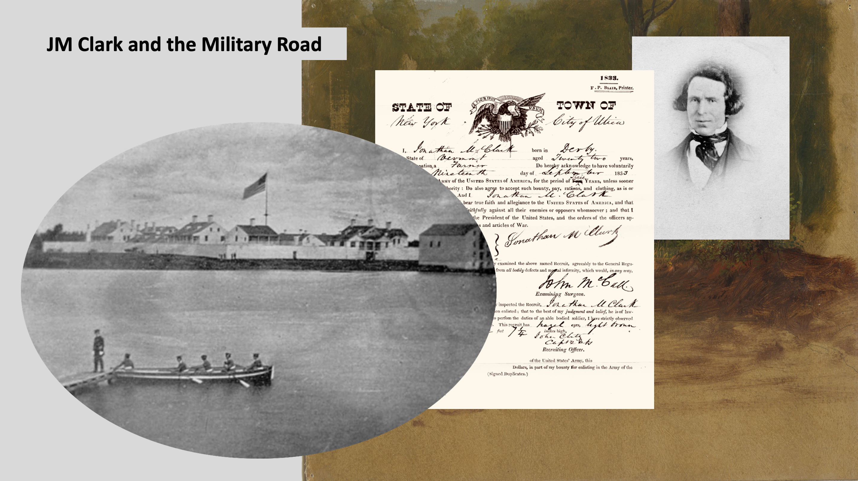
I just put the final edits on my upcoming presentation for the Fall Meeting of the Wisconsin Society, Daughters of the American Revolution. I’ll be talking about Wisconsin’s first federal road—the Old Military Road—and the men that built it, including our own Jonathan M. Clark.
One of my WSDAR presentation slides. From left: JMC’s army post, Fort Howard (Green Bay), JMC’s army enlistment paper, JMC portrait photo.
My talk is scheduled to run for 30 minutes and, as is often the case, I had to cut a lot of information from the presentation in order to keep it inside the time limit. But I don’t want all of those research tidbits to go to waste, so I’m going to post them in a few posts here on the blog. Today, I’m going to list, comment on, and link to some of the key sources that helped me put my WSDAR presentation together. If you have any interest in Wisconsin’s early roads and related transportation issues, I encourage you to check out these sources. Most are freely available online, and I’ll provide links where I can. Happy reading!
Durbin & Durbin, 1984
To my knowledge, the best, most detailed, and most comprehensively researched and documented article about the Military Road remains “Wisconsin’s Military Road: Its Genesis and Construction” by Richard D. Durbin and Elizabeth Durbin. It was published in Wisconsin Magazine of History (WMH), Vol. 68, No. 1, Fall, 1984.
The Durbins appear to have consulted a huge number of primary sources, especially the deep collections of the Wisconsin Historical Society (WHS) and the National Archives and Records Administration (NARA). Their article is lavishly illustrated with vintage and modern maps, and will allow the reader to retrace the path of the original Military Road through modern Wisconsin. The authors also document in great detail the many twists and turns of the road’s legislative and appropriations history and the military’s involvement in the project.
Durbin and Durbin is essential reading for this subject, and can be read for free via the Wisconsin Magazine of History Archives at WHS’s excellent website (link to article). And speaking of the Wisconsin Magazine of History…
Today is Labor Day, the holiday celebrating the working men and women of our nation, and I thought I’d commemorate the day with a lightly-revised re-post of this piece from 2023.
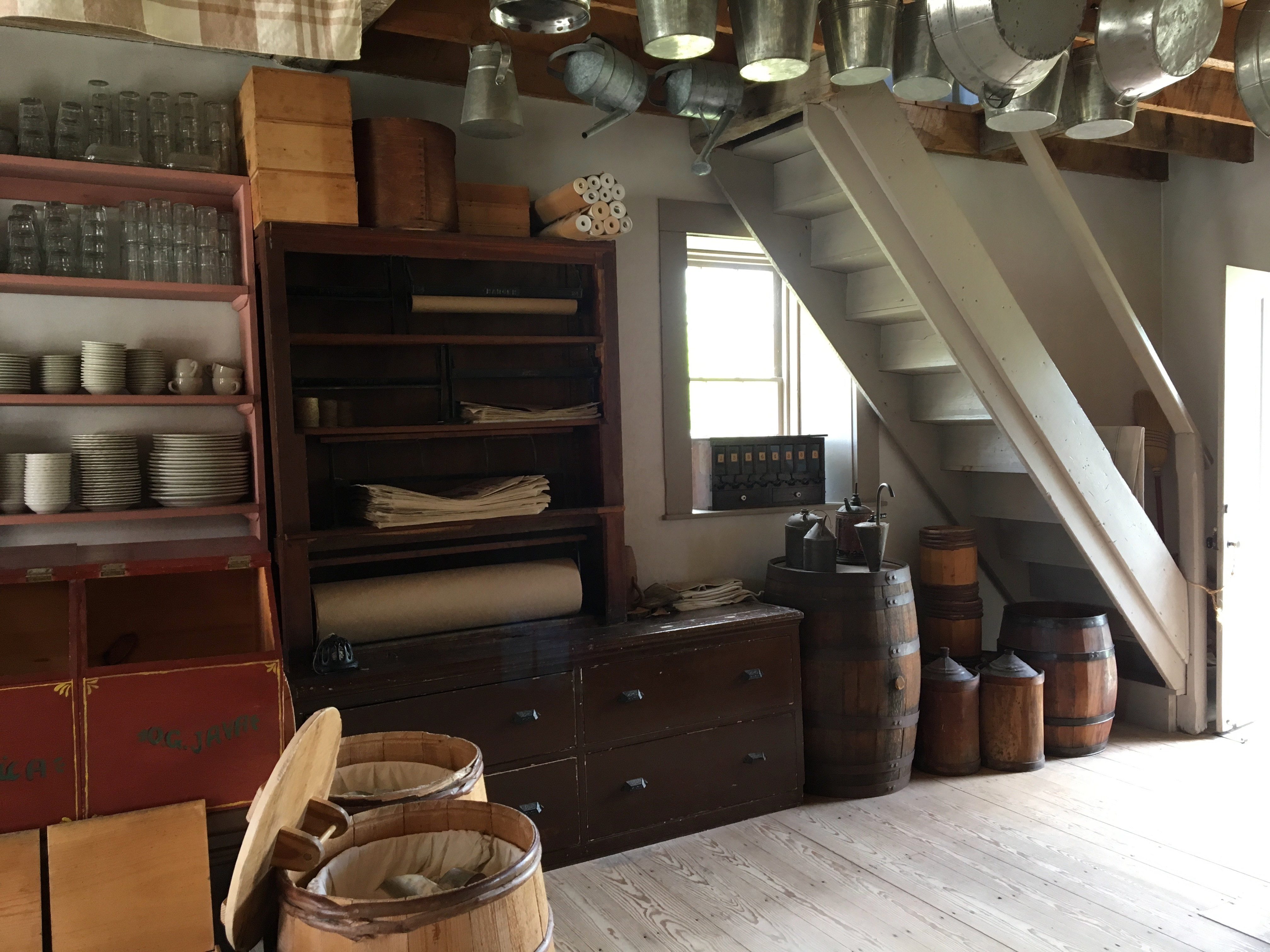
This Labor Day, I’ll be at home, working on my upcoming lectures for the state DAR and the Cedarburg History Museum. Last year, I had to work at our local mercantile establishment. You know, a store kind of like this one, only much bigger, stocked with just about anything you need for modern living:
I don’t really have the day “off” today—too much writing to do—and won’t be marching in a parade, but I’d still like to honor the holiday and salute the American worker, past and present. With that in mind, let’s revisit some of the nineteenth-century occupations we’ve talked about previously at Clark House Historian, highlighting a few of the many skills, trades, and occupations common during the Clark House era.
Since it is a holiday, I’m not going to add long commentaries to each photo. Enjoy the photo galleries, and click each gallery to open larger versions of each image. And click the highlighted links to visit the original CHH posts, filled with lots more information about the different skills, tools, and jobs, and the full image credits.
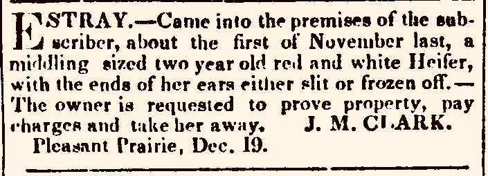
“Estray. […] J. M. Clark” advertisement, Southport [later Kenosha] Telegraph, Dec. 26, 1843, page 4
Hey! How did Mequon’s Jonathan M. Clark end up with a stray red and white heifer on his farm in…Pleasant Prairie, the most southeasterly township in all of Wisconsin, some 56 miles south of the Jonathan Clark House? The short answer is: he didn’t. The man that placed this “stray cow” advertisement in the December 16, 1843, issue of the Southport (later Kenosha) Telegraph was is not “our” J. M. Clark.
So many J. M. Clarks
Throughout the nineteenth century, many men seem to have been referred to, at least in print, by the initial letters of their first and middle names. The builder of Mequon’s Jonathan Clark House was no exception. Many of the documents made during his lifetime refer to him as “J. M. Clark,” and he often signed his name that way as well.1
“J. M. Clark,” signature of Jonathan M. Clark, from his final U.S. naturalization papers, 1853.
Unless the researcher is careful, it’s easy to make assumptions and presume that the “J. M. Clark” that built our historic Mequon home in 1848 is identical with the other “J. M. Clark” men that appear in various Wisconsin Territory documents, land patents, newspapers, and histories. Unfortunately, this is not always the case. To be certain that the “J. M. Clark” referred to in a particular source is “our” Jonathan M. Clark, we need to understand the “who, what, where and when” of each document or event that may—or may not— have involved our Jonathan.
I’m sure my list of suspects is incomplete, but (surprise!) it has turned out to be much longer and more complicated than anticipated. With that in mind, I think I’m going to need several CHH posts to sort out some of the most easily mistaken “J. M. Clark” men that lived and worked in the central and southeastern parts of Wisconsin Territory, yet were definitely not our J. M. Clark, the man born in Lower Canada (or Vermont) in 1812 that went on to build the historic Jonathan Clark House in Mequon in the 1840s.2
Let’s start with earliest and most northerly of these settlers, the first of several Christian ministers surnamed Clark that had links to Wisconsin Territory army posts that were home to our Jonathan M. Clark and his comrades during their service with the U. S. Army’s 5th regiment of infantry, 1833-1836.
I’m working on several substantial and related posts centered around maps and documents that describe the early settlement of Stanstead Township, Lower Canada, from about 1791 to 1810. There are several Clark families involved, and I am investigating whether any of these early Stanstead Clarks might be kin to our Jonathan M. Clark. Research is going along well enough, but the writing is taking more time than planned.
But I couldn’t let this Monday pass without sharing a special map with you, one that I came across while searching for more relevant maps in the digital collections of the Library and Archives Canada (LAC) website. Today’s map is, I believe, the earliest map of what would eventually become the Eastern Township of Stanstead, Lower Canada.
The Search for JMC’s roots continues!1 For the last few months, I’ve spent hour after hour reading through hundreds of digitized pages of the various manuscript land petitions and related documents that form the Land Petitions of Lower Canada, 1764-1841 database at Library and Archives of Canada (LAC).2
The good news is that I have found a lot of information about various early Clark (or Clarke) surname immigrants that petitioned for land—and actually settled on it—in Lower Canada during the relevant years of circa 1791-1840. Many of the documents that I’ve found contain information about these Clark immigrants, their families, and from whence they come. This is important, as we need to sort the Patriot, Vermont-related Clark families from other Clark immigrants from New York and New England (including American Loyalists), and the various Anglo-Canadian Clark families that sought land in the Eastern Townships at the same time. So, you know what that means…
We need another map!
Now that we have all this data, we need a way to organize and present it. And since so many of our rejected candidates earn their “Nope, not our Clark family” status because they settled far away from Stanstead, I thought it was time to make a big map of where these various Clark petitioners for Lower Canada land actually ended up. Then, in theory, we can eliminate the Clark families that settled “too far” from Stanstead (and adjacent Derby, Vermont), and focus on the Clarks that settled in or near Stanstead itself.
It’s going to take a while to assemble and present all the data. So we need a big,easy to read map created around the time of Jonathan Clark’s childhood and/or youth, from about 1812 until his arrival in New York state in 1831. (The latter date is flexible, as long as we find a map that predates the reorganization of the townships into larger counties in 1847.) We’ve presented some great Lower Canada maps here at CHH but, as is typical of that era, if they are accurate and detailed, they also tend to be visually “busy” and hard to read. But, dear readers, I finally found just the thing…
248 years ago today, representatives of all thirteen of Britain’s American colonies, gathered “in congress” in Philadelphia, and publicly declared our independence from “George the Third, by the Grace of God, King of Great Britain, France, and Ireland, Defender of the Faith, and so forth,” and his distant and unresponsive legislature. The Americans proposed to separate—forever—from their Divinely appointed King, and form a new and independent nation, the “united States of America.” This decision was bold, completely unprecedented in a world dominated by autocratic monarchs, and potentially fatal for anyone that supported this Declaration of Independence. From the King’s point of view, the authors, his subjects, were committing treason.
After a public reading of the Declaration of Independence at Bowling Green, on July 9, 1776, New Yorkers pulled down the statue of King George III.
The authors of the Declaration were clear-eyed about the stakes, yet unwavering in their desire to separate from the King. They closed their—our—Declaration of Independence with their unanimous avowal that, […] for the support of this Declaration, with a firm reliance on the protection of divine Providence, we mutually pledge to each other our Lives, our Fortunes and our sacred Honor.
The Declaration of Independence is our pivotal foundational document. People risked their lives and fortunes by creating and signing it. Thousands of Patriots died in the subsequent War of Independence in order to make the “united States of America” a reality. A large number of British-Americans, still loyal to their monarch, fled the 13 colonies and migrated to the King’s remaining possessions to the north, including Nova Scotia and the Province of Quebec.
Through it all, the ideals expressed in the Declaration inspired generation after generation of Americans, including Jonathan Clark and his ancestors, as attested in this excerpt from daughter Caroline (Clark) Woodward’s 1893 biographical sketch:
[…] Jonathan M. Clark, was a Vermonter of English descent, who, born in 1812, of Revolutionary parentage, inherited an intense American patriotism.
Jonathan Clark and his Mequon neighbors—including native-born “Americans,” as well as more recent immigrants from Ireland, the German lands, the United Kingdom, Nova Scotia, and elsewhere—knew the Declaration, read it aloud at patriotic events (in English and German!), and shared its anti-monarchical sentiments.
This July 4th, before you head to the beach or light the barbecue, why not refresh your memory and read the document that created our nation, and forever declared our freedom from the “absolute Despotism” of kings?
In Congress, July 4, 1776.
The unanimous Declaration of the thirteen united States of America,
When in the Course of human events, it becomes necessary for one people to dissolve the political bands which have connected them with another, and to assume among the powers of the earth, the separate and equal station to which the Laws of Nature and of Nature’s God entitle them, a decent respect to the opinions of mankind requires that they should declare the causes which impel them to the separation.
A recent CHH comment from reader Meredith Johanson brought an interesting local history newspaper article to my attention. It’s from page 8 of the Sherbrooke [Québec] Daily Record of May 13, 1911, now available as a digital image at BAnQ.
The article was compiled by H. I Bullock, of Beebe Junction, Stanstead county, Québec. The compiler was a descendant of one of the earliest white settler families in the Eastern Townships of Lower Canada, the Ruiter family and, as of 1911, s/he possessed a number of historic Ruiter family documents.
The contents of several of these documents are presented in detail in the article, and include discussions of Ruiter family settlement in the Stanstead area, how farms and homes were created in the heavily-timbered forests of the “New Townships,” various local trades and supplies and their respective wages and costs, and early military affairs, with local militia rosters from 1809 and 1817.
The article is focused on Ruiter family documents, but many other early settlers are mentioned by name, including one William Clark, and several men with the surname Merrill. As far as we know—at the moment—none of these men are directly related to our Jonathan Morrell/Merrill Clark. But the information in this 1911 article does give a hint of what life was like for the first Stanstead-area settlers—such as Jonathan M. Clark’s still-unknown parents—in the early 1800s.
Bartlett, W. H, artist, A First Settlement, drawing, brown wash on wove paper, c. 1840, National Gallery of Canada, public domain.
I have made no cuts to the article, and since the original is long, I have not included extra commentary. I have added more white space between paragraphs for ease of reading, made a few clarifications and citations in the Notes that follow, and added an illustration not found in the original. Here’s the complete transcription. I hope you find it interesting: