Last time, we illustrated our look at Ft. Howard with this detail from the first widely-available map of Wisconsin—and the first map of the territory based on official surveys—published in 1837:
Detail, Topographical map of Wisconsin Territory / compiled from the Public Surveys on file in the Surveyor General’s office … by Samuel Morrison, Elisha Dwelle [and] Joshua Hathaway, 1837. American Geographical Society Library Digital Map Collection, University of Wisconsin–Milwaukee. Click the detail map to open a larger version in a new window. Click here for a link to the complete map at UW-M with full bibliographic information.
This detail—showing Fort Howard, Navarino and, at the top, the southern end of Green Bay—was the subject of a Monday: Map Day! post in December, 2020, and gives a good picture of the topography and settled areas along the final miles of the Fox River as it empties into Green Bay. But on closer look, the details of the fort and its layout are very vague, limited to one X-shaped symbol. For a better understanding of Fort Howard in its most active era, we need to look at the actual 1823/1827 federal survey upon which the 1837 map was based:
Private Claims at Green Bay, 1823/1827
Detail, [Title section] of map, Private Claims at Green Bay, surveyed in July, Aug.t & Sept.r 1823; see image of complete map for full citation. Click to open larger image in new window.
Our series of “How’d they get here?” posts is written to illustrate the nuts and bolts of how our early Mequon pioneers travelled from their original homes or ports of arrival in North America to the newly opened federal lands in Wisconsin Territory, circa 1830-1850. Today’s post continues our previous post, a first-person description of 1830s frontier tourism that we called How’d they get here? Detroit to Ft. Howard, 1834 (part 1).
Picking up where we left off…
Wednesday, July 16, arrival at Green Bay
On Wednesday, as the Sun was slowly sinking to its repose in cloud of the most gorgeous and variegated colors, we arrived at the extremity of Green Bay, and about two miles up the Fox river, we landed at Navarino,2 receiving as we passed a salute from Fort Howard, on the opposite side of the river.
Detail, Topographical map of Wisconsin Territory / compiled from the Public Surveys on file in the Surveyor General’s office … by Samuel Morrison, Elisha Dwelle [and] Joshua Hathaway, 1837. American Geographical Society Library Digital Map Collection, University of Wisconsin–Milwaukee. Click the detail map to open a larger version in a new window. Click here for a link to the complete map at UW-M and its bibliographic information.
This map detail—showing Fort Howard, Navarino and, at the top, the southern end of Green Bay— is from the Topographical map of Wisconsin Territory, published in 1837 and the subject of a Monday: Map Day! post in December, 2020. As a reminder, this 1837 map shows all the lands officially surveyed by the federal government up to the time of publication. In 1837, the territory to the north and west of the Fox and Wisconsin rivers was still reserved for Wisconsin’s Native Americans, so the lands to the north and west of the Fox River are left (mostly) blank on this official map. But this land was not at all “empty.” The Indians, the forests, the wildlife, some of the old Métis and Anglo-American settlers—and the army—were all on the left bank of the Fox River in 1837, as they were in 1834, when the steamboat Michigan and its passengers arrived in Green Bay.
Our series of “How’d they get here?” posts is written to illustrate the nuts and bolts of how our early Mequon pioneers travelled from their original homes or ports of arrival in North America to the newly opened federal lands in Wisconsin Territory, circa 1830-1850. Today’s post looks at another trip to Ft. Howard on the steamboat Michigan, this time in the summer of 1834.
In Monday’s How’d they get here? – JMC to Ft.Howard, 1833, we looked at the likely probability that from October 16 – 30, 1833, Pvt. Jonathan M. Clark left the U.S. Army’s recruiting depot at Ft. Niagara, New York, and traveled the Great Lakes from Buffalo, New York, to his new post at Fort Howard, Green Bay, Michigan (later Wisconsin) Territory. To make that late-season journey the army chartered the new and lavishly appointed steamboat Michigan.
Great Lakes Tourism – Summer, 1834
Less than a year after that October, 1833, voyage the owners of the Michigan announced two special excursions to the “Far West” for the summer of 1834. The first of these was scheduled to leave Buffalo on Thursday, July 10, headed to “the Sault St. Marie (foot of Lake Superior), Michigan and Green Bay, touching at the ports on Lake Erie and at Detroit,” and would “embrace a distance of nearly 2000 miles, during which, passengers will have an opportunity of viewing the splendid scenery of Lakes Erie, St. Clair, Huron, Superior and Michigan, and the rivers, straits and bays connected with them.”
“Steamboat excursion to the Far West,” advertisement, Albany Argus, June 6, 1834, page 3, via genealogybank.com. Click to open larger image in new window.
The second trip would depart Buffalo on August 12th, and would take in all the sights of the July trip, and additional notable points along the south and east coasts of Lake Michigan, including Chicago, Michigan City, “St. Josephs,” and the mouth of Michigan’s Grand River. What could an 1834 tourist to the “Far West” expect on such an excursion? We have a first-hand report from the July trip, which includes an eventful stop at Jonathan M. Clark’s post at Ft. Howard.
Our series of “How’d they get here?” posts is written to illustrate the nuts and bolts of how our early Mequon pioneers travelled from their original homes or ports of arrival in North America to the newly opened federal lands in Wisconsin Territory, circa 1830-1850. Today’s post looks at how Jonathan M. Clark may have made the trip west to Wisconsin in October, 1833. And, in the process, we correct an important, but incorrect, date in the JMC timeline.
Jonathan M. Clark heads west…
Back in June, 2016, I outlined what we knew about Jonathan Clark’s 1833 enlistment in the army and subsequent journey to Green Bay:
After enlisting in the Army in Utica, New York, on September 19 and confirming his enlistment on September 28, 1833, Jonathan was sent to one of the Army’s “general depots.” I’ve not yet established which one he went to; the most likely places were the Jefferson Barracks in St. Louis, Missouri, or Kentucky’s Newport Barracks, on the south side of the Ohio River, across from Cincinnati. It’s possible that Jonathan may have reported to another “depot,” perhaps Ft. Niagara, New York, which was the home base of JMC’s recruiter, Capt. Clitz.
In any case, less than a month later Jonathan arrived at Fort Howard, Michigan [later Wisconsin] Territory. Fort Howard was the headquarters of the army’s Fifth Regiment, with easy water access via Lake Michigan to Ft. Dearborn, Chicago and, via the Fox and Wisconsin rivers, to Forts Winnebago and Crawford.
Now that we know more about early transportation routes from New York to Wisconsin it seems unlikely that JMC reported to either the Jefferson Barracks or the Newport Barracks before arriving at Fort Howard. Yes, it would have been relatively easy to travel from Utica, New York, to either the Jefferson or Newport barracks via the Erie Canal to Lake Erie, and then the Ohio canals and Ohio river. But Fort Howard was one of the army’s northernmost posts. If JMC had been shipped to one of the main personnel depots in Kentucky or Missouri, the northward trip from either place to Green Bay and Ft. Howard would have been needlessly long and difficult.
Fort Niagara
I now suspect that Jonathan Clark mustered in to service at Fort Niagara, New York.2
Map detail, showing western New York state, including Ft. Niagara, the Erie Canal, and Buffalo, from Poussin, Guillaume-Tell, Travaux d’ameliorations interieures projetes ou executes par le Gouvernement General des Etats-Unis d’Amerique, de 1824 a 1831 … Atlas. Paris, Anselin, Libraire, pour l’art militaire, les sciences et les arts, […],1834. Imprimerie de Lachevardiere, rue du Colombier, No. 30. Credit, David Rumsey Map Collection, David Rumsey Map Center, Stanford Libraries, non-commercial use permitted under Creative Commons license. Click image to open larger image in new window.1
Big News! I’ve found a photograph of Jonathan M. and Mary (Turck) Clark’s eighth and final child, Jennie Marietta Clark, at the age of about 25 years old. This is one of only a handful of photos we have of any members of Jonathan and Mary Clark’s family and (to the best of my knowledge) the first image we have of Jennie:
Jennie Clark Morrison (“Mrs. F. S. Morrison”), detail from “Class of 1882, University of Michigan School of Dentistry; UM_DDS_1882.” Public domain, courtesy of University of Michigan Bentley Historical Library, University of Michigan Library Digital Collections. Accessed: September 15, 2021. Click to open larger image in new window.
Dental College, Class of 1882
Our portrait of Jennie is a detail taken from this composite portrait of the University of Michigan’s School of Dentistry, Class of 1882:
This week our attention has been turned to New Orleans, the adopted home of Peter Turck’s eldest son—and Mary (Turck) Clark’s younger brother—Joseph R. Turck. Our previous post, J. R. Turck – from Mequon to New Orleans, sketched a brief outline of Joseph’s life, including a half century lived in the Crescent City. That post also discussed Joseph’s very brief service in a Confederate “home guard” militia unit during the Civil War, and how he had lost touch with his Wisconsin family during and after the capture of New Orleans in 1862.
A rare Peter Turck manuscript
We have a number of examples of Peter Turck’s signature—and an occasional bit of text in his hand—from various land documents, marriage licenses, federal census pages, citizen petitions, and other documents from the 1840s to the 1860s. Today’s document is the only letter I have seen in Peter Turck’s own hand, and it gives us a rare insight into Peter Turck’s paternal feelings (as expressed in the typically florid and deferential language of the era) and some additional details about the life of his eldest son, Joseph.1 It’s an interesting letter, and I thought you might like to read it.
Turck’s letter is preserved as part of National Archives and Record Administration (NARA) publication M345, Papers Relating to Citizens, compiled 1861 – 1867. These are letters sent by U.S. civilians to the Provost Marshal’s office of the Union Army. The Provost Marshal was, essentially, the chief of the military police in an area occupied by Union troops.
This letter was published in NARA series M345, microfilm roll 0270, item Joseph R. Turck. It’s accessible online at Fold3.com (pay site). The transcription is mine, and preserves Peter Turck’s occasional curious spelling or punctuation errors. The original letter appears to cover two sides of a single sheet of paper. The original envelope was not microfilmed; it was probably discarded by the New Orlean’s provost marshal’s staff in 1862.
Milwaukee, July 25th 1862
Turck, Peter to Gen. Benjamin F. Butler, July 25, 1862, page 1 of 2. NARA publication M345 Papers Relating to Citizens, compiled 1861 – 1867. Roll 0270, Joseph R. Turck, Fold3.com, accessed 20 March 2014. Click to open larger image in new window.
It’s the end of a long week. I’m kind of tired, and don’t feel much like writing. I think i’ll take off my hat and rest a bit.
Waud, Alfred R., [Lincoln Resting in Chair, Top Hat in Lap.], United States, between 1860 and 1865. Library of Congress. Click to open larger image in new window.
UPDATED August 16, 2021, to include more information on the Ho-Chunk language, inadvertently omitted from the original post.
I’m working on more posts for our series about the early Mequon immigrants and “How’d they get here?” I needed a map that showed all of the Great Lakes, as well as the Eastern seaboard states and ports from which these immigrants began their westward journeys. And hey, I found a great map from 1825, the year the Erie Canal was completed:
Finley, Anthony and David H. Vance, Map Of The United States Of North America. Philadelphia, 1825. Credit, David Rumsey Map Collection, David Rumsey Map Center, Stanford Libraries, non-commercial use permitted under Creative Commons license. Click image to open larger map in new window.
One of the really neat aspects of researching and writing about Clark House history on this site is the feedback I receive from blog readers. I love hearing from you, whether you have a comment or a question about the topic at hand, or perhaps there is something else that you want to know more about.
[Occupational Portrait of a Salesman], Three-Quarter Length, Seated, Displaying His Wares. Daguerreotype, between 1850 and 1860, cropped and lightly color-adjusted. Library of Congress. Click to open larger image in new window.
“UPDATED…”
History is never “done.” No one can know it all. There are always new sources with fresh information, and new ways to look at well-known material. A question or a new bit of information from a reader will often prompt additional research or a correction to previous statements. The result is that this blog—and our knowledge of the Clark family, their neighbors, and their era—is constantly evolving.
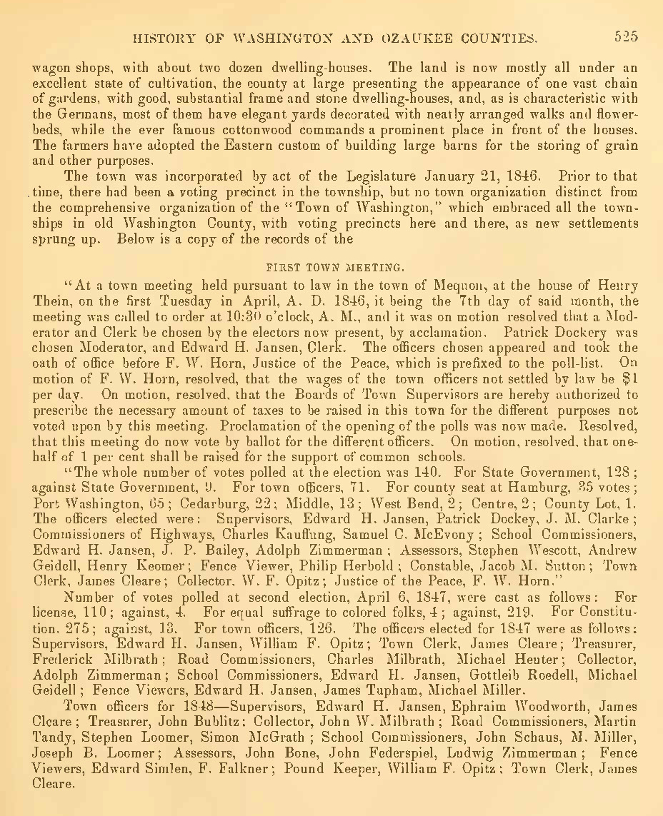
Every now and then it pays to take a fresh look at familiar sources. One of the key sources for the early history of Mequon and its parent counties is The History of Washington and Ozaukee Counties, Wisconsin […] Illustrated, published in Chicago in 1881. And even though I’ve been using this book for Clark House research for over a decade, I still discover (or, in this case, re-discover) facts about Mequon—and, specifically, Jonathan M. Clark—that I had either not known before, or had noticed, “filed for future reference,” and forgotten to write about. Today’s post fixes one such omission.1
The first meeting of the Town of Mequon, April 7, 1846
Page 525 of The History… contains a load of information about the beginnings of town government in Spring, 1846. Unfortunately, it’s the sort of densely worded, 19th-century “history” writing that makes the reader want to skip ahead to something less dry. Here, take a look; start with the first full paragraph, beginning “The town was incorporated”…
The History of Washington and Ozaukee Counties, Wisconsin […] Illustrated, Western Historical Co., Chicago, 1881, page 525, pdf of full book via GoogleBooks. Additional online, pdf copies can be found at Hathi Trust, the Wisconsin Historical Society and Archive.org. Click to open larger image in new window.
That’s a lot of info: names, dates, job titles. Let’s break things up a bit and take a closer look at what’s going on as old Washington county transitioned from the original county-wide system of government to the new system, in which each town will be responsible for much of its own governance.