Our annual Memorial Day post, first published in 2020. Updated for 2024 with new information about the Civil War service of Isham and Emily (Bigelow) Day’s eldest child, Cpl. James Lemon Day (1834-1863).
Graves of Unknown Union Soldiers, Memphis National Cemetery, photo by Clayton B. Fraser, (Library of Congress), public domain. Memphis National Cemetery is the final resting place of Mequon’s Watson Peter Woodworth, and almost 14,000 of his Union Army comrades.
Today is the day our nation officially observes Memorial Day. For many Americans, Memorial Day represents “the first day of summer,” and is traditionally celebrated with trips to the lake, picnics, parades, and sales on cars, appliances, and other consumer goods.
But for many of us, Memorial Day remains rooted in its origins as Decoration Day. The first national observance was in 1868, when retired general John A. Logan, commander and chief of the Grand Army of the Republic—the Union veterans’ organization—issued his General Order Number 11, designating May 30 as a memorial day “for the purpose of strewing with flowers or otherwise decorating the graves of comrades who died in defense of their country during the late rebellion, and whose bodies now lie in almost every city, village, and hamlet churchyard in the land.”
On this Memorial Day, let’s take a moment to remember what this day truly represents.
It’s already the second week of May, 2024, and summertime will soon be here. At our southeastern Wisconsin home the first spring flowers are done, and the next round of blossoms have been blooming for a week or two. The peas will soon be in the ground, and we already harvested enough rhubarb to make two and a half small jars of jam. The tomato and pepper seedlings and the squashes will go in soon, and I need to put up a trellis or two so we can start the big patch of green beans. So even though it’s “early” by the standards of previous years, we’ve got gardening on the mind here at the Historian’s house, and I thought you might enjoy a slightly-belated repost of this annual favorite, which first appeared here in April, 2021. Cheers!
Planning the garden
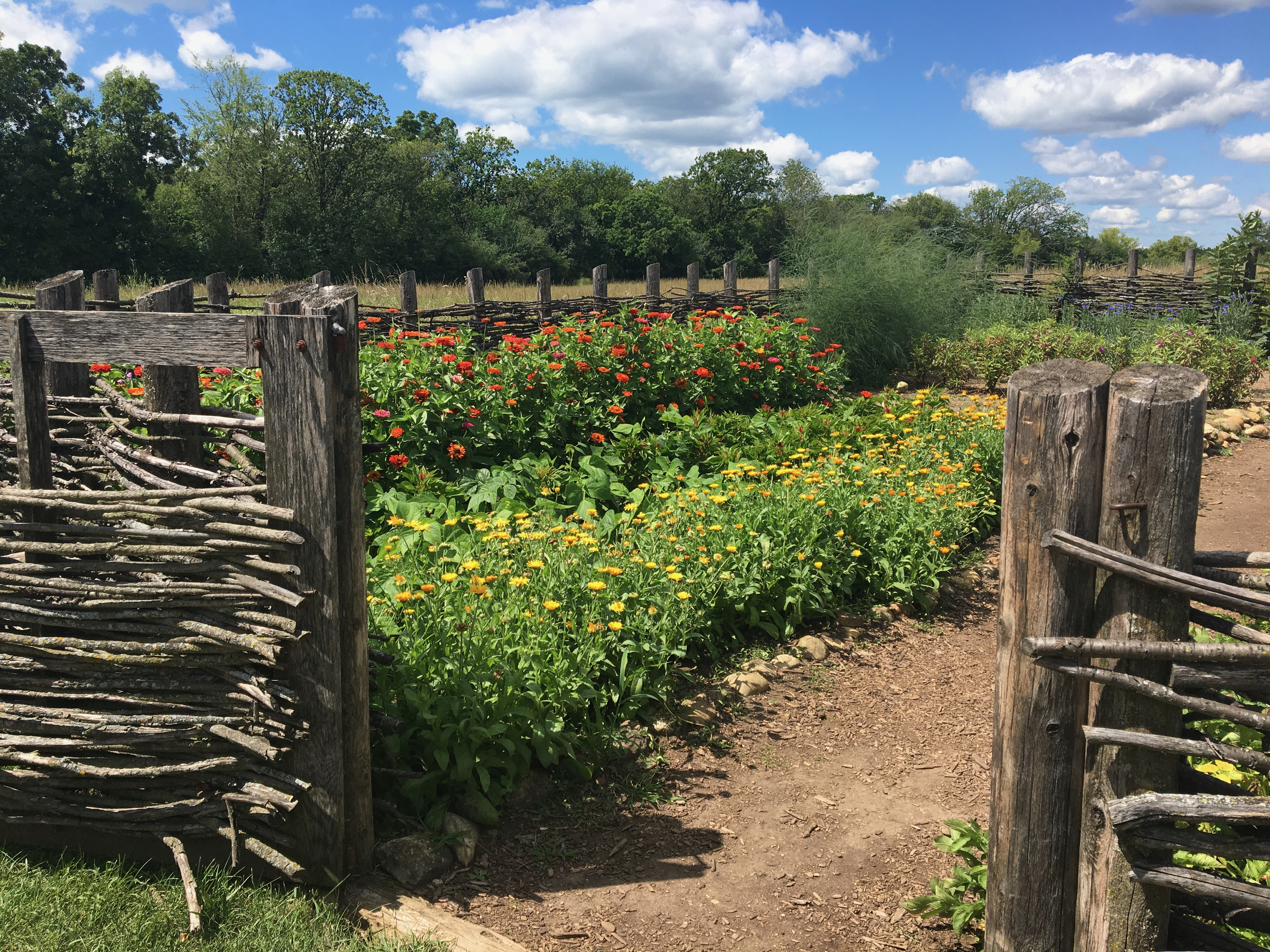
It’s early April, and the growing season is not far off. For a farmer like Jonathan M. Clark, it’s a little early yet for plowing and sowing, but not too early to make plans and sharpen the tools. For a farmer’s wife, like Mary (Turck) Clark, it’s not too soon to think about the farm garden, its crops and layout.
Garden at the Turck-Schottler House, 1870s Hessian Immigrant Farm, Old World Wisconsin. Photo credit Reed Perkins, 2022.1
I don’t know if Mary and Jonathan were regular readers of the popular and affordable farmers’ almanacs of their era; I wouldn’t be surprised if they were. There were many to chose from. Perhaps they had a copy of something like:
Advertisement, “Choppers Wanted,” Milwaukee Sentinel, August 27, 1839, page 3.
After years of searching for original reports and drawings or photographs of early Wisconsin road construction, I find myself entangled among piles of information and images on just that topic. Now, the challenge is to organize the best of this material into a few CHH blog posts and wrap up—for now—our most recent excursion along Wisconsin’s earliest roads.1
Like contractor George E. Graves in Sauk Harbor [Port Washington] in 1834 (above), I could probably use the assistance of some (digital) “axe-men” to clear my way forward. Perhaps some hearty fellows such as these…
Time for one more follow-up to our recent posts Monday: Map Day! – Wisconsin’s Federal Roads in 1840 and JMC, the Army, and the Military Road, 1835-1840. As I mentioned in that “Monday: Map Day!” post, I recently found some unique maps and related documents in the digitized collections of the National Archives and Records Administration (NARA), in particular a group of maps and drawings created in 1840 by members of the army’s Corps of Topographical Engineers under the supervision of Capt. T. J. Cram.
Before they get lost in my files, I thought I’d share the other documents from Capt. Cram’s 1840 survey that have survived and been digitized by NARA. I’ve already said quite a bit about these 1840 maps and drawings; now I’m most interested in gathering the remaining 1840 documents and their bibliographic citations here for reference. So not much commentary today, but lots of images. And—as always—I recommend clicking on each item to open a larger, higher-resolution image in a new window.
Bridges on the Green Bay Road
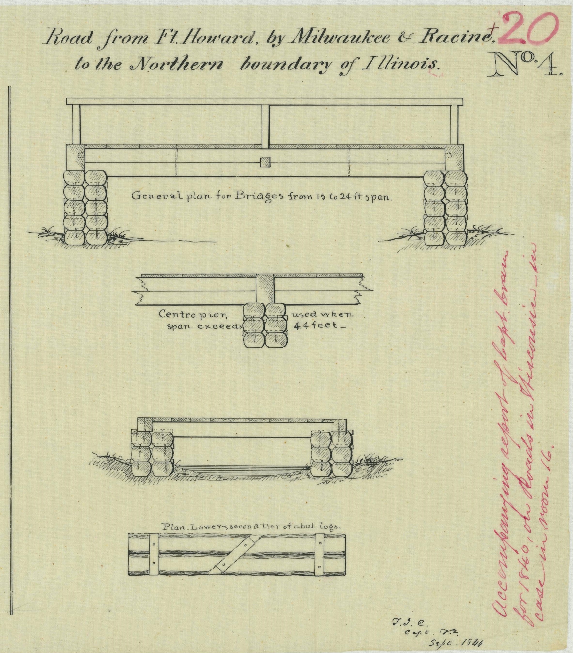
The first item is of particular interest for Clark House history fans, as it provides additional details about old Washington/Ozaukee county’s first federal road, the north-south route connecting Fort Dearborn, Chicago, to Fort Howard at Green Bay. The drawing is part of a larger document; this portion is titled “Road from Ft. Howard, by Milwaukee & Racine, to the Northern boundary of Illinois.”
The drawing illustrates construction details of the simple wooden bridges that were part of the Green Bay Road, circa 1840. This road, and these bridges, comprised the main north-south transportation route for the U.S. Mail and for immigrants and settlers of the new counties of southeast Wisconsin Territory. The Clarks, Turcks, Bonniwells and other early Mequon pioneers would have crossed bridges like these on their trips to and from Milwaukee, Grafton, Port Washington and beyond on the Green Bay Road.
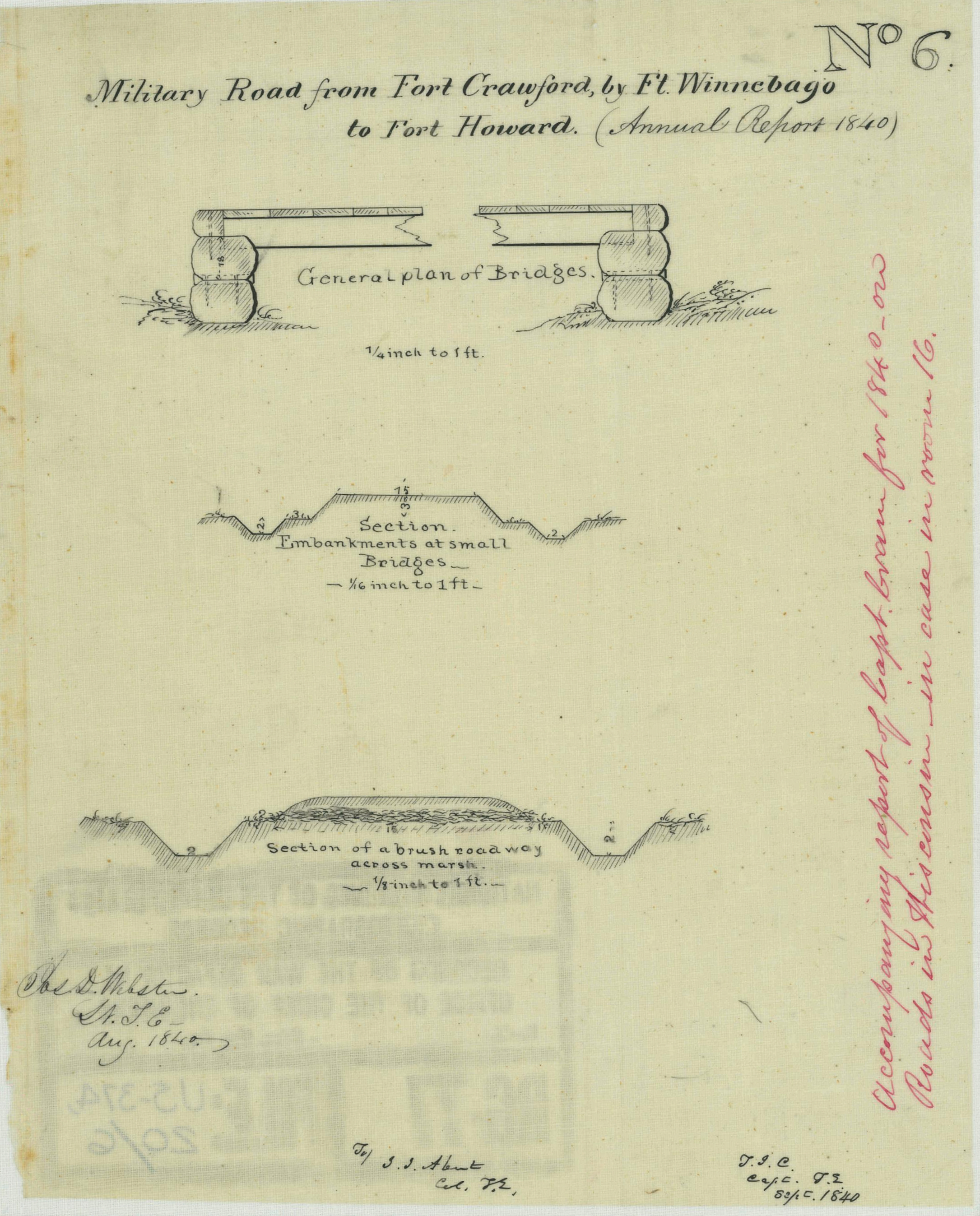
Today’s post is a follow-up to our recent Monday: Map Day! – Wisconsin’s Federal Roads in 1840. It features another document created by the U.S. Army’s Corps of Topographical Engineers and preserved in the collections of the National Archives and Records Administration. Today’s drawing interests us as it documents—in some detail—the kind of road building work that Pvt. (later Sgt.) Jonathan M. Clark performed as a member of Company K, 5th Regiment, U.S. Infantry.
Webster, Jos. D, et. al., “Military Road from Fort Crawford to Fort Winnebago to Fort Howard (Wisconsin),” NARA, Record Group 77: Records of the Office of the Chief of Engineers, Series: Civil Works Map File, File Unit: United States, accessed here, April 14, 2024.
This document interests us because after JMC left the army he, with many of his early Mequon neighbors, spent a good part of the 1840s surveying, cutting, clearing, and grubbing out some of old Washington/Ozaukee county’s earliest roads. In the process, these pioneers had to bridge streams and rivers of various sizes and depths, and find ways to keep the unpaved roadway dry and firm. How did they do it with the limited supplies and tools at hand?
Today’s document shows how the U.S. Army solved some of those issues a bit farther north, on Wisconsin’s east-west Military Road. The techniques and approaches to road construction use there may have influenced how JMC and our early county road builders solved the problems of building roads in the forests, wetlands, and open prairies of 1840s Washington county.
For the record, here’s one more source to add to our list of “not Jonathan M. Clark’s kin” dead ends in the search for JMC’s roots in northern Vermont and Lower Canada, circa 1800-1840.
Clark, Almon W., 1541-1907. The Clark family genealogy in the United States, a genealogical record showing sources of the English ancestors. Stamford, N.Y., Press of the Mirror-recorder, 1907. Library of Congress
…as I prepare my March 9th Civil War presentation for the Cedarburg History Museum, try to sort out the full story of Mequon-Thiensville’s earliest settlers and landowners (including first postmaster John Weston), and look through a bushel of fresh sources in our ongoing search for Jonathan Clark’s kin who hail, we think, from somewhere up around where Derby, Vermont meets Stanstead, Québec.
The Clark House Historian and his crack research team, searching for answers in the written record…1
As you can see, I’ve got work to do in order to dig out from under—and make sense of—the big pile of historical documents that I’ve accumulated over the past several weeks.
So no new CHH post today, but I’ll be back soon with more Clark House history.
Today’s Monday: Map Day! revisits and makes a correction to an interesting map that we first discussed here on October 29, 2017, and then re-visited on July 11, 2020. And for unknown reasons, that original 2017 post—according to my monthly WordPress statistics report—was the most-viewed post on this site for the month of January, 2024, with 341 views (!).
Burr, David H. Map of the Northern Parts of Ohio, Indiana and Illinois and Michigan and that part of the Ouisconsin Territory lying East of the Mississippi River, 1836, detail of title & author. Library of Congress.
The 2020 re-post was originally conceived as a kind of addendum to our June-July, 2020, multi-part discussion of the earliest Wisconsin territorial, state, and federal censuses. It also served to locate Jonathan M. Clark in Wisconsin Territory during his U.S. Army service from September, 1833, to September 19, 1836.
Today’s post includes one particular correction that I’ve been meaning to make for a while. When I added my original annotations to a detail of this map (in red), in 2017, I made an error. I mislabeled Sgt. Jonathan M. Clark’s location at the time he mustered out of service, a temporary army camp along the under-construction military road from Fort Howard (Green Bay) to Fort Winnebag0 (Portage). JMC’s muster-out location was always referred to in the records of the Fifth Regiment of Infantry as “Camp Hamilton.” For some reason, when I made my annotated detail map, I incorrectly labeled this place “Ft. Hamilton.” A minor error, but worth correcting , especially now that this map is receiving fresh attention.1
It’s 1836. Where’s…Wisconsin?
In September, 1836, Sgt. Jonathan M. Clark was discharged from the U.S. Army at “Camp Hamilton,” Wisconsin Territory, after serving his three-year term of service with Co. K, Fifth Regiment of Infantry.2 One year later, in the autumn of 1837, Jonathan’s future wife Mary Turck would make the long trip from Palmyra, New York, to Milwaukee and finally Mequon, Washington County, Wisconsin, with her parents Peter and Rachael Turck and six younger siblings. By the end of 1840 Jonathan and Mary would be married and starting their family in Mequon.
That seems simple enough, until you take a moment to wonder how much Jonathan—or especially Mary and her family—knew about this new Wisconsin Territory. Jonathan had been in the territory since October, 1833, mostly on post at Ft. Howard. In the last year or so of his service he was busy cutting trees and building bridges for the military road along the Fox River waterway from Ft. Howard (Green Bay) towards Ft. Winnebago (near modern Portage). As a road-building soldier, Jonathan might have done some surveying and seen—or helped draw—a variety of maps of the military road and its vicinity. But for a better overview of this new territory, Jonathan or Mary might have sought out a map such as this:
Time for a few Random Bits of History: Early Mequon Settlers’ Disambiguation Edition.
John Weston & John Western
Mequon’s first postmaster, John Weston, is mentioned many times in the essential local history book, the History of Washington and Ozaukee Counties, Wisconsin … Illustrated. Western Historical Publishing Co., Chicago, 1881. Using the “Find” function on my PDF copy of the book,1 I found results for “John Weston” on pages 475, 476, 523, 524 and 545.
There is also an entry for “T. Weston” among the names on the “First Poll-List of Washington County” on page 316. I am confident that this is a typographical error and that “T. Weston” is actually John Weston.
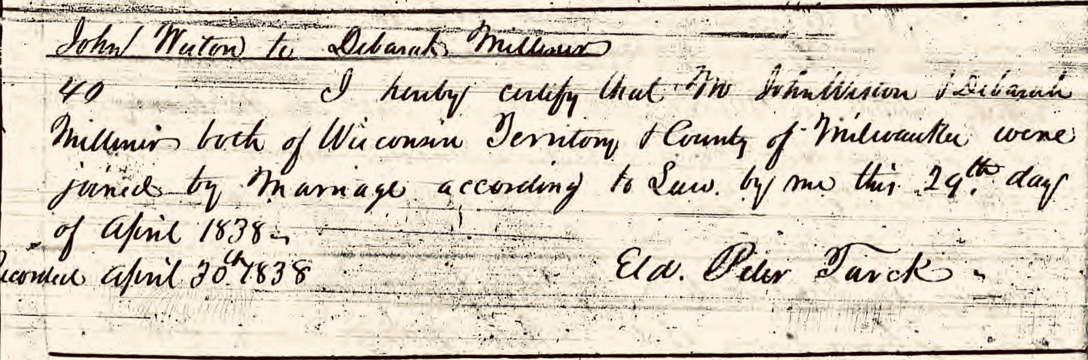
The same source also records, among the early area settlers, one “John Western,” on pages 316, 477 and 478. Is this the same man as John Weston? I have carefully compared a number of sources, including the early minutes of the county road supervisors and deeds in the Washington/Ozaukee county deed books, and I am convinced that during the early years of settlement in the Mequon-Milwaukee area, “John Weston” and “John Western” are the same person, namely John Weston, born in New York about 1800, and married to Deborah Milliner in Milwaukee County in April, 1838. I’ll have examples from the documents that explain my reasoning in a future post.
Fun fact: Mary (Turck) Clark’s father, (Baptist) “Elder” Peter Turck, was the officiant at the Weston-Milliner wedding in 1838. It was the fortieth marriage recorded in the first volume of marriage records for Milwaukee county (and its still-attached for judicial purposes neighbor counties, including old Washington/Ozaukee county).2
With the Weston & Western mystery solved—for the moment—let’s see what other bits of error and confusion we can clear up…
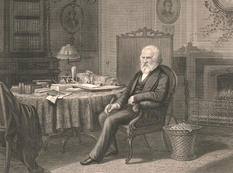
As the volunteer historian for the Jonathan Clark House Museum, it’s my privilege to investigate, document, and share with you the stories of the Clarks, their relatives, neighbors, friends, and try to bring to life the world in which they lived. Much of my work involves finding, studying and analyzing relevant documents and visual images, and much of that work happens “behind the scenes,” so to speak.
The Clark House Historian at work (note discarded drafts and as-yet unfinished projects).1
Each week (well, “each week” is the goal…) I share some of my findings with you on this blog. Now that the old year is gone, I thought it might be worthwhile to see what we accomplished at Clark House Historian in 2023. Let’s begin by taking a quick look at the numbers…