There was still some daylight left after the annual “Pie on the Patio” event at the Clark House last week, so I thought I’d stop by Mequon’s historic Isham Day House on my way home. Isham Day was one of Mequon’s first settlers, and he built his tidy home, sometimes known as the “Yankee Settler’s Cottage,” in 1839. It’s a town landmark, and I’d never been to see it.
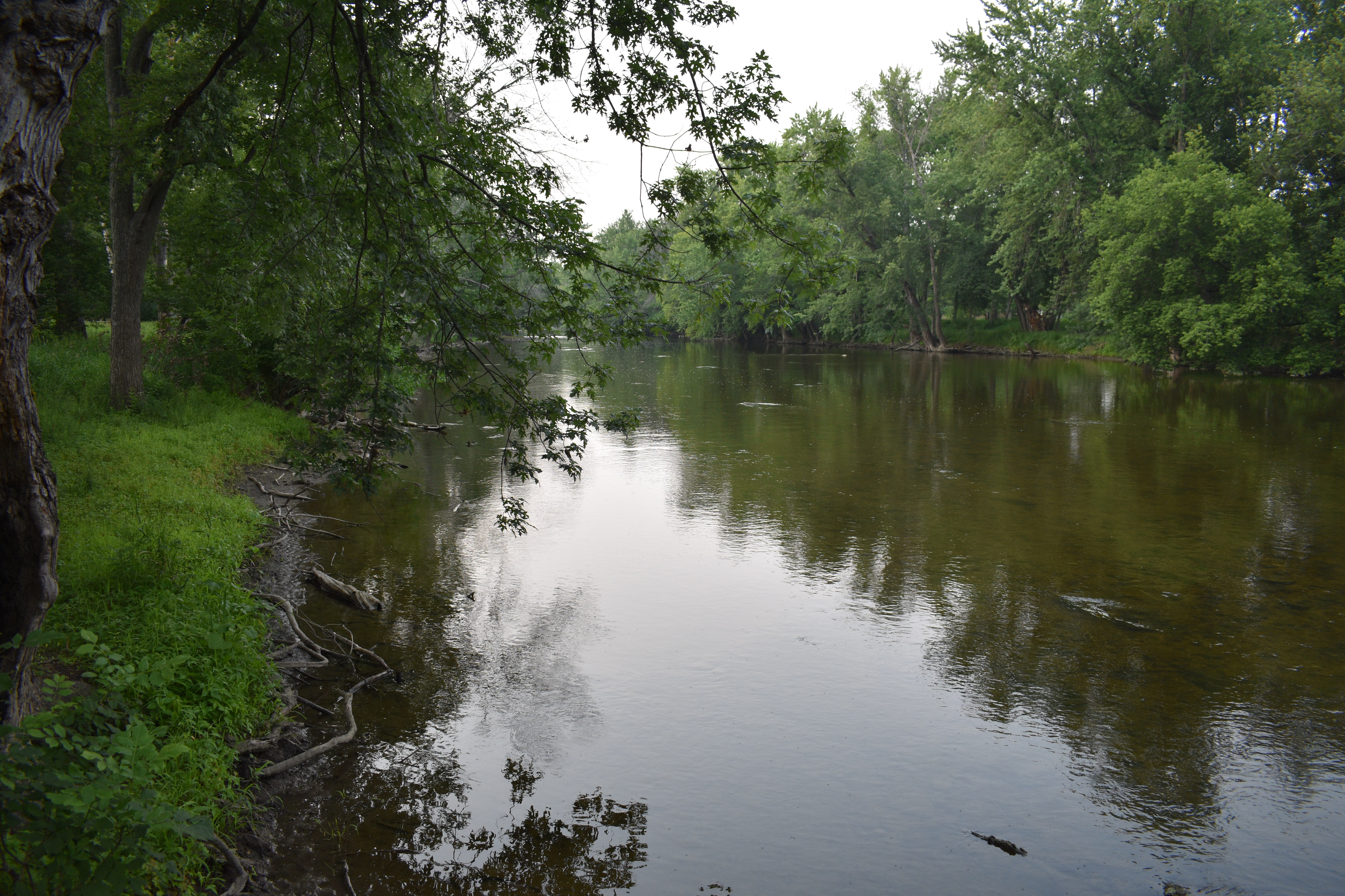
While enjoying my first look at the Day House, I also took the opportunity to meander through the adjacent Settlers Park. It’s a beautiful little park, with an accessible boardwalk that leads down to and along the west bank of the Milwaukee River. It’s a short, easy stroll; I highly recommend it. By the time you reach the riverbank you’ll forget you are in a busy 21st-century downtown.
Photo credit: Anna Perkins, 2021. Click any photo to open gallery and access larger versions of the images.
It’s been a busy summer here at Clark House Historian, with lots of research, writing, editing, and posting, and most of the essays illustrated with unique historical maps, documents, and images. And more Clark House history posts are queued up in draft form, awaiting final touches.
I don’t know about you, but I’m ready for a short break, starting with a cool drink while watching the birds in the backyard. Here’s one frequent visitor to our house:
Havell, Robert, engraver, after John James Audubon, Yellow Bird or American Goldfinch, 1828, plate 33 from The Birds of America (1828-1838), hand-colored engraving and aquatint on Whatman wove paper. National Gallery of Art, Gift of Mrs. Walter B. James. Public domain. Click to open larger image in new window.
This is another installment in the transportation-themed series that began with our July 6, 2021, Monday: Map Day! – How’d they get here? and continues from there.
Queen, James Fuller, [A Man and a Woman Standing at the Entrance to a Trail Through a Forest] (detail), graphite drawing on cream paper, circa 1850-1870. Library of Congress
I’m still writing the next two (or three) longer, narrative installments of our “How’d they get here?” series, which I began working on to assist Clark House education director Margaret Bussone and our education team as they develop a transportation-themed project for use at the Jonathan Clark House later this summer.
For quite a while I was worried that I would not be able to find enough visual material to adequately illustrate our early Mequon immigrants’ journeys of the 1830s and ’40s. It turns out that I now have a lot of material to share with the education team—and with you. Rather than hold on to it until my longer posts are complete, I thought I’d do something different today.
I’m still working on the next two (or three) more substantial installments of our “How’d they get here?” series, so here’s another “bonus” post, while you’re waiting. If you need to catch up, the series began with our July 6, 2021, Monday: Map Day! – How’d they get here? and continues from there.
Some weeks ago, when I began to research this topic, I was worried; I didn’t think that I would be able to find enough information and visual material to adequately illustrate our Mequon immigrants’ journeys of the 1830s and ’40s. It turns out that I now have (cough) a boatload of material to sort through and organize. So more of “How’d they get here?” is coming soon. Meanwhile, here’s another fine Great Lakes steamer from the time of our Mequon pioneers:
N. Currier. Buffalo & Chicago steam packet Empire State: M. Hazard, Commander. New York, circa 1835-1856 (probably 1848 or later, see below). Photograph of hand-colored lithograph. Library of Congress. Click to open larger image in a new window.
Ahoy, readers! Here’s another “bonus” post for our ongoing series “How’d they get here?” If you need to catch up, the series began with our July 6, 2021 post Monday: Map Day! – How’d they get here? and continues from there.
I’m working on the next two (or three) more substantial installments of the series, metaphorically steaming against the wind through virtual piles of documents, books, and historical images. It’s going well, but taking a bit longer than I hoped. So while you’re waiting, how about another beautiful Great Lakes ship image, this time courtesy of the National Gallery of Art in Washington:
[American artist, 19th century], Steamship Erie, probably 1837, oil on canvas, National Gallery of Art, Gift of Edgar William and Bernice Chrysler Garbisch. Public domain. Click to open larger image in new window.
UPDATED August 12, 2021 (twice), with more information on Orange Dibble’s derrick, illustrated below. See my reply to the question from reader Chester T. Hartwell in Comments, below.
UPDATED July 29, 2021, to include some new general information and details about several of the images sent by reader Robert Randall, second vice-president of the Camillus Canal Society. For Mr. Randall’s full message, see Comments, below. For more on the society’s Camillus Erie Canal Park, click here.
How the early settlers came to Mequon, c. 1835-1850 (part 3)
Our series of “How’d they get here?” posts is written—in part—to help our education team put together a Clark House Museum educational activity. The idea is to illustrate the nuts and bolts of how our early Mequon pioneers travelled from their original homes or ports of arrival in North America, to the newly opened federal lands in Wisconsin Territory, circa 1835-1850. (If you missed ’em, the previous parts are here and here, with a bonus image, here.)
Erie Canal images – 1825!
Finally!! For years, I’ve been searching for images of the unique, low-draft, narrow-sided, low-height, lock-length boats designed for and used in the earliest years of the Erie and Champlain canals (c. 1825-1840). And year after year, I had no luck finding such images…until this week.
You might be thinking, “hasn’t Clark House Historian already spent quite a bit of time on the Erie Canal?,” and you’d be correct. But it’s hard to overstate the national and international importance of the Erie Canal on world trade and American westward expansion in the decades after its opening in 1825. And while we have used maps to illustrate the migration routes of some Mequon settlers (such as the Turck, Gay, Bonniwell, and Woodworthfamilies), I wasn’t able to adequately illustrate the details of how they travelled in the early days of the canal era. Until now.
Today’s treasure trove of early canal images is from Cadwalleder Colden, et. al., Memoir…at the Completion of the New York Canals, New York, 1825. Many of these images are from the “extra-illustrated” edition in New York Public Library Digital Collections; you can download and enjoy a scanned copy of the standard edition of the book via GoogleBooks. Yes, these images are a bit early for our generally 1835-1850 “How’d they get there?” timeframe. But these are, by far, the best visual representations of early New York canal travel that I have seen. Even though Jonathan M. Clark, and the Woodworth and Bonniwell families and other Mequon settlers did not travel on the canals until the 1830s, these images depict scenes they would have experienced along the Champlain and Erie canals.
Please take a close look at each image for the “big picture,” then click on each and zoom in on the details. All the images can be clicked on to open as a larger, downloadable, image in a new window. All images are believed to be in the public domain, and I encourage you to enjoy, download, save, share and use them as you see fit.
Canal Boats
Here is an excellent view of a group of the new canal boats, loading freight and soliciting business at the North [i.e., Hudson] River docks, New York City, before heading up the Hudson to Albany and the canals:
Canal boats on the north river, New York, in Cadwallader Colden, et. al., Memoir…at the Completion of the New York Canals, New York, 1825. Image from “extra-illustrated” edition in New York Public Library Digital Collections, scanned copy of standard edition of book via GoogleBooks.
How the early settlers came to Mequon, c. 1835-1850 (part 2)
This is part 2 of a series focused on how our Mequon pioneers traveled to southeast Wisconsin in the early days of white settlement, between roughly 1835 and 1850. If you missed part 1, it’s here at Monday: Map Day! – How’d they get here?, plus a short post with bonus image at Steamboat’s coming!
From the late 1820s until about 1850, if you wanted to get from the settled American northeast to the open frontiers of the West, the fastest, safest, and cheapest way to get there was by water. Thousands of New Yorkers, New Englanders, Canadians, and overseas immigrants that had come from Europe to America’s eastern ports, found the Great Lakes route—west on the Erie Canal to Buffalo, and then by water through the Lakes to Chicago and Milwaukee—was their preferred route to new homes on the western frontier. And many of those settlers traveled on the newest, fastest craft afloat: the steamboat.
View of Detroit…1837
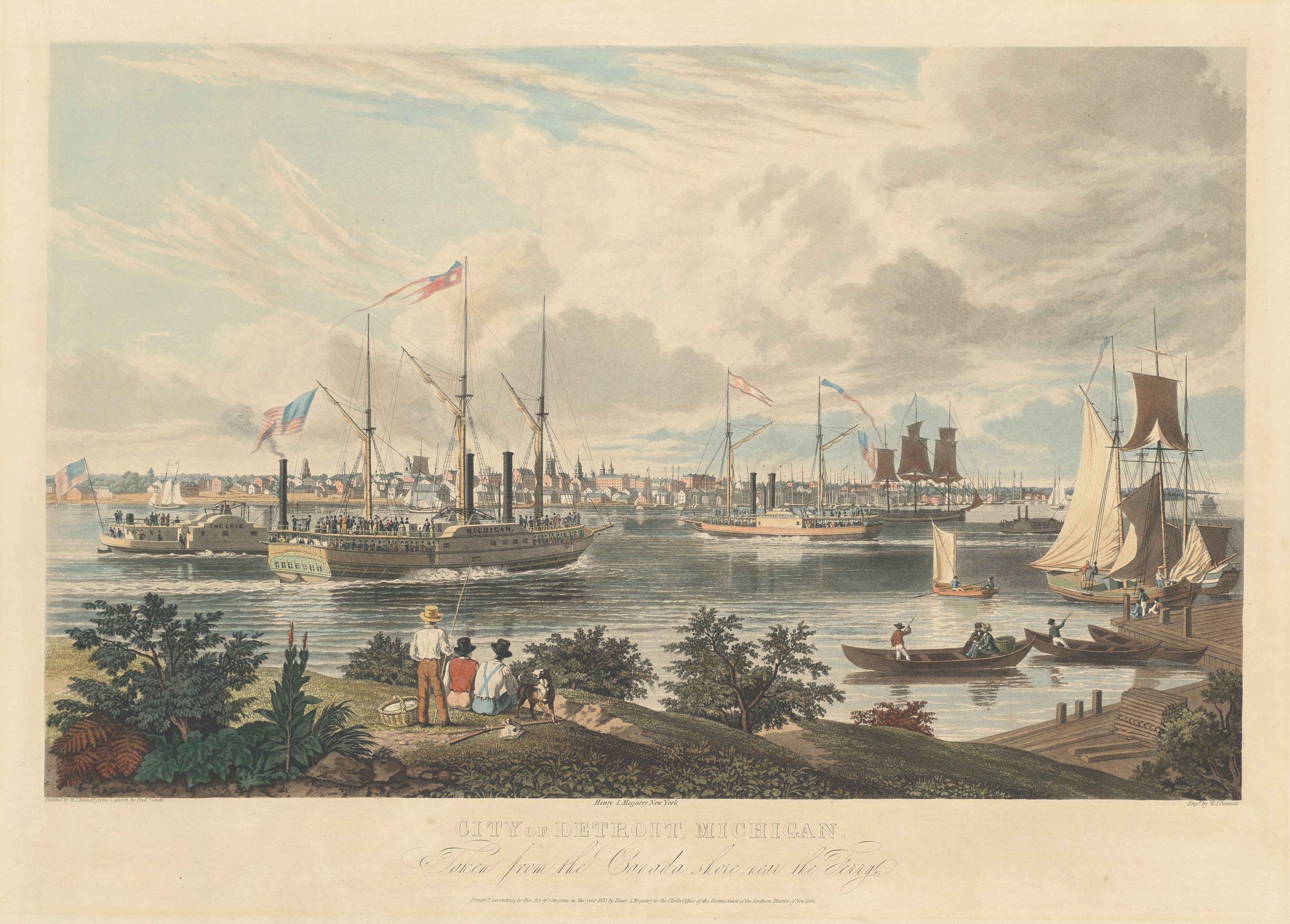
Here’s something really special for Clark House history lovers, a detailed drawing of the various kinds of sailing ships and steamboats as they passed by Detroit, Michigan on a sunny day in 1837, as seen from the Canadian side of the Detroit River. Take a close look; this is the view Peter Turck and his family—including daughter Mary, the future spouse of Jonathan M. Clark—would have seen as they traveled to Milwaukee in August of the same year1:
Bennett, William J., after a sketch by Frederick K. Grain, City of Detroit, Michigan. Taken from the Canada shore near the Ferry., hand-colored aquatint on engraving, ca. 1837. National Gallery of Art, Collection of Mr. and Mrs. Paul Mellon. Public Domain. Click to open larger image in new window.
Our “How’d they get here?” transportation series will continue shortly, starting with lots of info on Great Lakes steamboats. Here’s a teaser:
Catlin, George, Artist, and St. Louis Mercantile Library Association. St. Louis in 1832. From an original painting by Geo. Catlin in possession of the Mercantile Library Association.Library of Congress. Click to open larger image new window.
UPDATED, February 11, 2024, to include a revised version of the annotated detail map of Ouisconsin, 1836. But for the full update—with additional notes and corrections—please see the most recent version of our discussion the Ouisconsin map of 1836 on our post of February 12, 2024. UPDATED, July 6, 2021, to answer a reader’s question: “Where was Jonathan Clark just before he went to Fort Howard?” Scroll down to Comments for the answer.
How the early settlers came to Mequon, c. 1835-1850 (part 1)
Clark House education director Margaret Bussone and our education team are putting together a project centered on how our Mequon pioneers traveled to southeast Wisconsin in the early days of white settlement, between roughly 1835 and 1850. I thought I’d help out by gathering some relevant materials and sharing them with the education team—and you—here on the blog.1
So this week we’re going to look at how the settlers found their way here, and how they traveled on land, lake, or river. Rather than writing lots of words about each map or image, I’d like to gather a whole bunch of useful items in each post and put them out there as resources for all to use. Later in the week, we’ll look at various modes of travel on land and on water. Today we’ll look at some maps.2 Some of these maps were readily available to our would-be immigrants, others might have been one-of-a-kind or otherwise hard to obtain.
An overview, The U.S. in 1834
When the following map was published in 1834, Jonathan M. Clark was finishing the first year of his three-year enlistment in the U.S. army. He was stationed at Ft. Howard, on the Green Bay of Lake Michigan, in what was then the civil District of Huron, a soon-to-be-outdated term for the western portion of the Michigan Territory.3
Mequon’s earliest settlers would be coming to lands that were poorly mapped and little understood by most European-Americans. The most this map could show—in a very general way—is where the “open” areas were for future migration and settlement.
Norris, William, and Daniel K Minor. Map of the railroads and canals, finished, unfinished, and in contemplation, in the United States. New York: Railroad Journal, 1834. Map. Library of Congress. Click to open larger map in new window.