Time for one more follow-up to our recent posts Monday: Map Day! – Wisconsin’s Federal Roads in 1840 and JMC, the Army, and the Military Road, 1835-1840. As I mentioned in that “Monday: Map Day!” post, I recently found some unique maps and related documents in the digitized collections of the National Archives and Records Administration (NARA), in particular a group of maps and drawings created in 1840 by members of the army’s Corps of Topographical Engineers under the supervision of Capt. T. J. Cram.
Before they get lost in my files, I thought I’d share the other documents from Capt. Cram’s 1840 survey that have survived and been digitized by NARA. I’ve already said quite a bit about these 1840 maps and drawings; now I’m most interested in gathering the remaining 1840 documents and their bibliographic citations here for reference. So not much commentary today, but lots of images. And—as always—I recommend clicking on each item to open a larger, higher-resolution image in a new window.
Bridges on the Green Bay Road
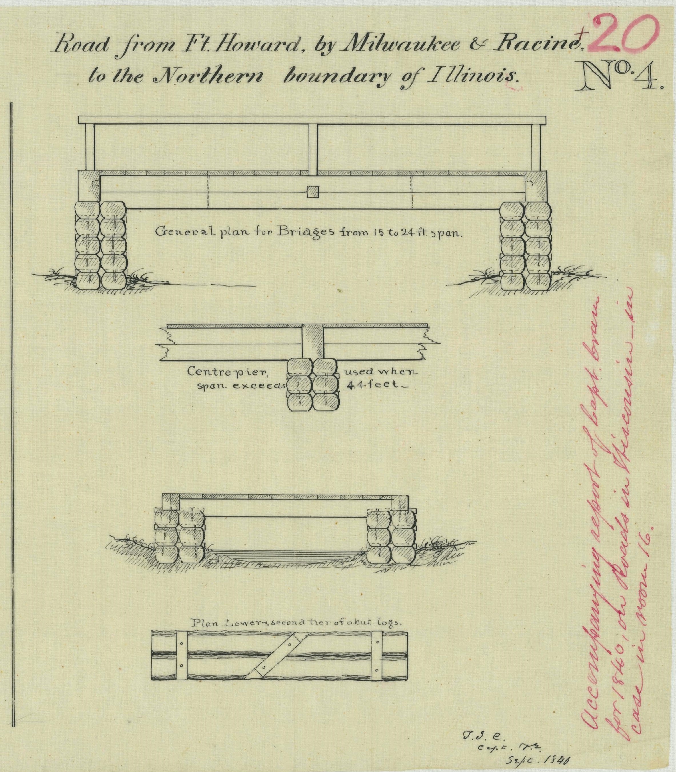
The first item is of particular interest for Clark House history fans, as it provides additional details about old Washington/Ozaukee county’s first federal road, the north-south route connecting Fort Dearborn, Chicago, to Fort Howard at Green Bay. The drawing is part of a larger document; this portion is titled “Road from Ft. Howard, by Milwaukee & Racine, to the Northern boundary of Illinois.”
NARA, full citation, below.
The drawing illustrates construction details of the simple wooden bridges that were part of the Green Bay Road, circa 1840. This road, and these bridges, comprised the main north-south transportation route for the U.S. Mail and for immigrants and settlers of the new counties of southeast Wisconsin Territory. The Clarks, Turcks, Bonniwells and other early Mequon pioneers would have crossed bridges like these on their trips to and from Milwaukee, Grafton, Port Washington and beyond on the Green Bay Road.
And that’s not all…
Road from Sauk Harbor to Dekorre (Wisconsin)
Our first image (above), was part of a larger document, cataloged at NARA as “Road from Sauk Harbor to Dekorre (Wisconsin).” The full drawing (below) includes additional examples that show the difference between the simple, shorter, bridges used on various 1840 federal roads in Wisconsin—such as these along the Green Bay road—and the new, “high-tech” truss style bridges used to span wider rivers and streams elsewhere in the territory. The drawing is worth zooming in on. There are detailed lists of the sizes and quantities of lumber employed, a “Bill of Iron,” detailing the spikes and bolts used on the bridge, and drawings showing the contour of the road embankments as they approach the bridge site.
And as a reminder, the 1840 port of “Sauk Harbor,” was (and still is) known as Port Washington, the county’s first settlement and eventually the seat of Ozaukee county. The settlement of Dekorre, or Dekorra, is located halfway across the state, on the left bank of the Wisconsin River, just a bit south of old Ft. Winnebago and modern Portage, Wisconsin.

Webster, Jos. D., et. al., “Road from from Sauk Harbor to Dekorre (Wisconsin),” with detail, “Road from Ft. Howard, by Milwaukee & Racine, to the Northern boundary of Illinois,” 1840, NARA, Record Group 77: Records of the Office of the Chief of Engineers, Series: Civil Works Map File, File Unit: United States, accessed here, April 16, 2024.
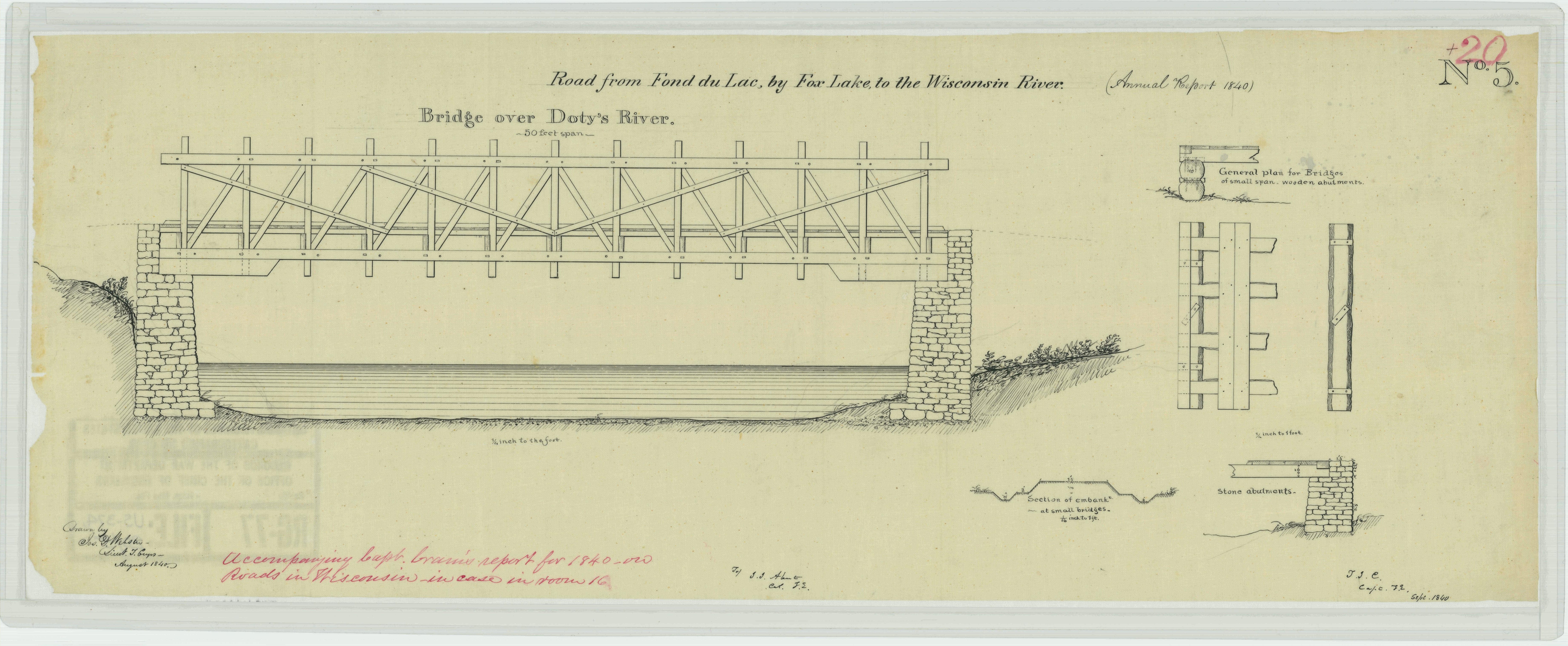
Road from Fond du Lac by Fox Lake to the Wisconsin River
More information on the new truss bridge construction methods, in particular for a “Bridge over Doty’s River.”
Webster, Jos. D., et. al., “Road from Fon [sic, Fond] du Lac by Fox Lake to the Wisconsin River,” 1840, NARA, Record Group 77: Records of the Office of the Chief of Engineers, Series: Civil Works Map File, File Unit: United States, accessed here, April 16, 2024.
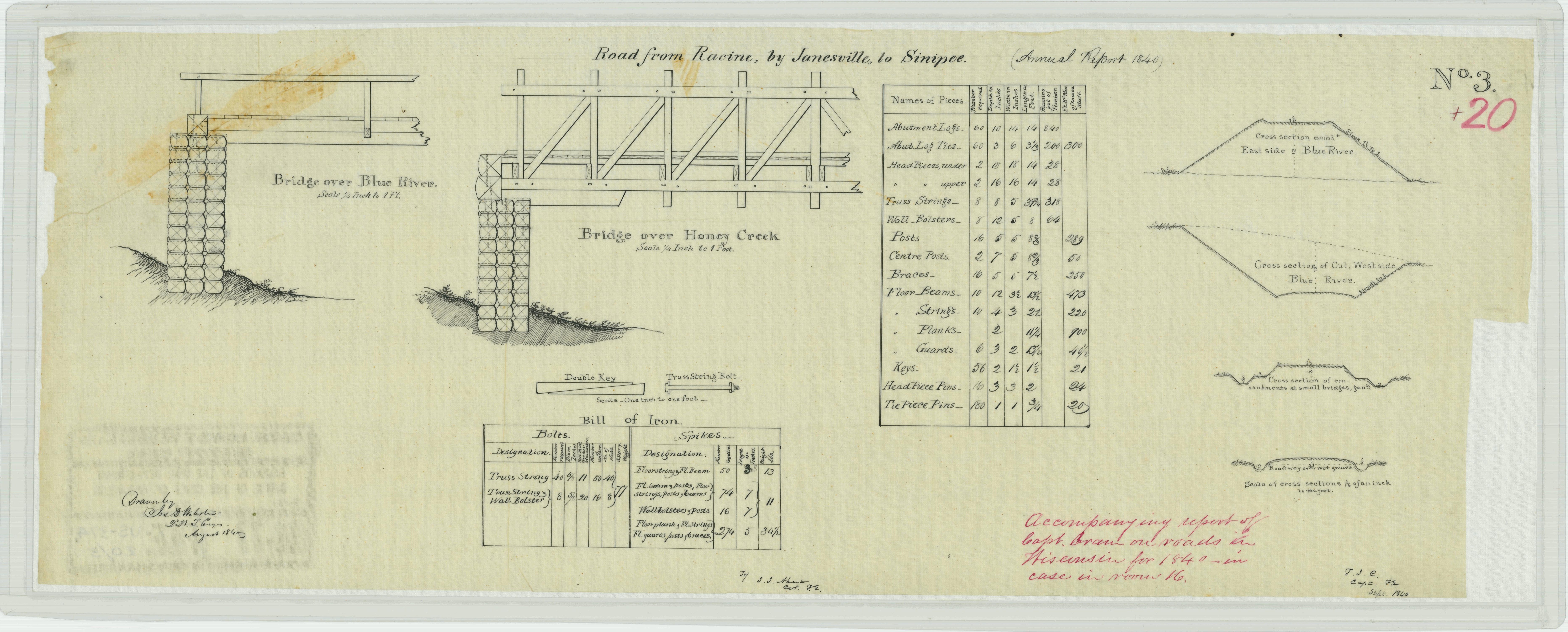
Road from Racine by Janesville to Sinipee (Wisconsin)
We close with three related drawings, sharing similar NARA catalog titles. All three drawings detail aspects of the southernmost east-west federal road in Wisconsin Territory, 1840. For more on this road, and its starting and ending points, see our Monday: Map Day! – Wisconsin’s Federal Roads in 1840, and be sure to zoom in on the companion map.
The first of the three drawings features descriptions of two more bridges, one over Blue River and one over Honey Creek, and includes detailed lists of lumber, spikes and bolts used, and section views of the roadbed as it crosses flat and sloped terrain.
Webster, Jos. D., et. al., “Road from Racine by Janesville to Sinipee (Wisconsin),” 1840, NARA, Record Group 77: Records of the Office of the Chief of Engineers, Series: Civil Works Map File, File Unit: United States, accessed here, April 16, 2024.
The second “Road from Racine by Janesville to Sinipee (Wisconsin)” document includes additional elevations and plans for various types and spans of bridges, and detailed lists of lumber, timber, spikes and bolts used in their construction.

Webster, Jos. D., et. al., “Road from Racine by Janesville to Sinipee (Wisconsin)” 1840, NARA, Record Group 77: Records of the Office of the Chief of Engineers, Series: Civil Works Map File, File Unit: United States, accessed here, April 16, 2024.
Our third, and final, “Road from Racine by Janesville to Sinipee (Wisconsin)” document is just the thing for would-be bridge builders (or their Congressional overseers). This is, in fact, a hand-written, 19th-century “spreadsheet” of the “Approximate Final Estimate of Cost of Constructing the 3r, 4th, 5th & 6th Divisions—or all that portion between Rock River [Janesville] and the Mississippi River [Sinipee]—87 Miles in extent.”

Webster, Jos. D., et. al., “Road from Racine by Janesville to Sinipee on the Mississippi (Wisconsin)” 1840, NARA, Record Group 77: Records of the Office of the Chief of Engineers, Series: Civil Works Map File, File Unit: United States, accessed here, April 16, 2024
The end of the road is in sight…
I hadn’t planned on a taking a deep dive into early Wisconsin Territory federal roads and their construction. But given that JMC spent a good part of his three-year enlistment at Fort Howard building one of the territory’s most important early roads, and that Jonathan Clark’s son Henry is reputed to have “served thruout war as carpenter with master of bridge construction” during the Civil War, I couldn’t resist sharing these NARA discoveries with you.
I’ve got one more post planned that will take a look at how these roads and bridges were built in the era before power tools and road-building machines. I’ve found some unique drawings and photographs that illustrate the kind of pioneer road and bridge construction that JMC and his neighbors undertook in the first decades of pioneer settlement in old Washington/Ozaukee county. I hope you find them interesting.
Back soon with more Clark House history.
________________________________
NOTES:
- Road building was one of the most important tasks taken on by federal and local governments in the early years of white settlement in Wisconsin Territory, and old Washington/Ozaukee county was no exception. Here’s a list of some Clark House Historian posts discussing various aspects of roads, road construction, and related topics in the early days of pioneer settlement:
• last week’s JMC, the Army, and the Military Road, 1835-1840
• Monday: Map Day! – Wisconsin’s Federal Roads in 1840
• County Government – Early Records
• Monday: Map Day! – The First County Roads, 1841
• Marking out the roads
• Roads into the Woods, 1841
• Another Road into the Woods, 1841
• The county’s earliest federal roads (plural)
• a short item on JMC and a local plank road, circa 1851, in: Working at Home
• and on a general, road-related note: How’d they get here? Walking & riding

Reed –
I have sent two messages to people in Columbia County to find out more about the person they refer to as “Surveyor Jonathan Clark” I will let you know as soon as I get a reply. Nina
LikeLike
Nina–
Thanks for working on this. I’d really like to know more about the mysterious Columbia County “surveyor Jonathan Clark.” I remember looking into this a few years ago with my available online sources, and I found nothing. Now, it’s **possible** that JMC was a civilian surveyor, “chain man” or “axe man” for the government surveys between his discharge from the Army in Sept., 1836, and his next appearance in the historical record in Milwaukee, in December, 1839, but I can’t find any mention of him doing this kind of work in the history books, in the newspapers of the day, or on the digitized General Land Office original survey maps of Wisconsin Territory from the mid- to late-1830s.
Good luck!
Reed
LikeLike
Pingback: Lost in the underbrush… | Clark House Historian