I spent much of January and February preparing my March 9th, 2024, Civil War presentation at the Cedarburg History Museum. In that talk I tried to take a more personal and local look at the war by examining the military service of few of the Cedarburg relatives and future in-laws of 1868-1873 Clark House resident Fred Beckmann. In my research, I found some unique stories of their years of Union service in the 9th and 26th Wisconsin Infantry Regiments, as well as the impact of the war on families and friends back home in Wisconsin.
I also found several new online collections of unique maps and historical documents. Today’s map is from one of those online sources, the digitized map collection of the National Archives and Records Administration (more on NARA and its holdings, below). This map was made 20 years before the Civil War, in September, 1840, and is one of the earliest—if not the earliest—maps of the federal roads in Wisconsin Territory.1
U.S. Roads in Wisconsin Territory, 1840

NARA’s title for this document is “Map Exhibiting the Routes of the United States Roads in the Wisconsin Territory,” 1840. The map is part of NARA Record Group 77: Records of the Office of the Chief of Engineers, Series: Civil Works Map File, File Unit: United States, accessed here on April 5, 2024.2
Captain Cram and the Topographical Engineers
Our map is an official document, surveyed, hand drawn, and approved by the federal government, under the supervision of one Captain T. J. Cram of the U.S Army’s Corps of Topographical Engineers.3
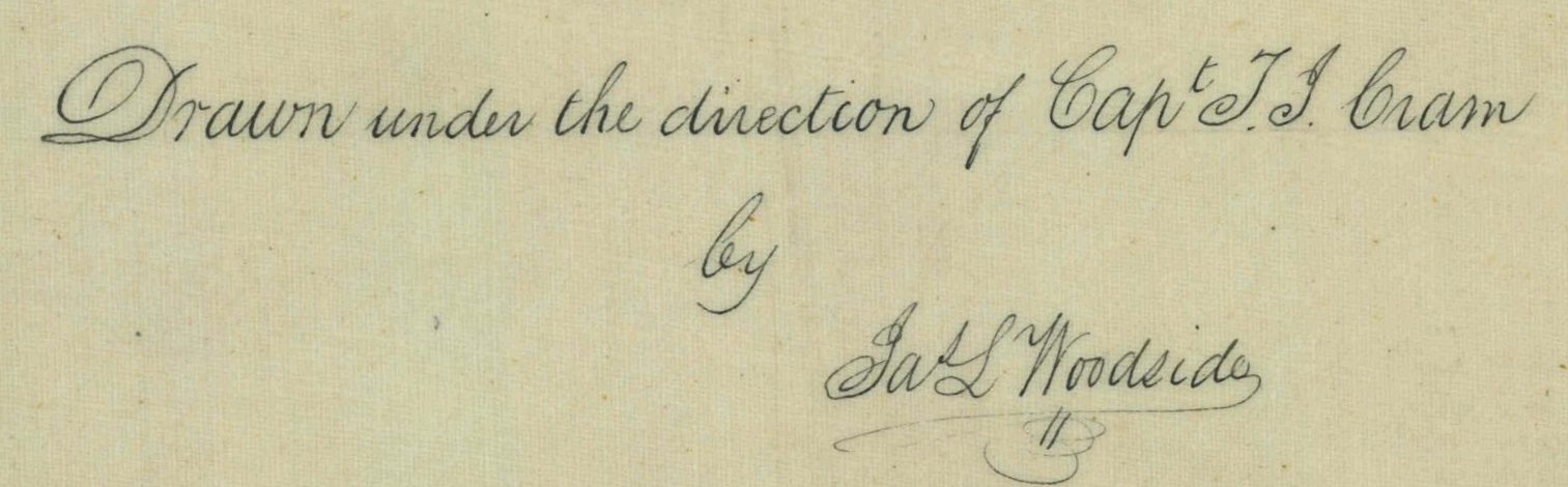
Captain Cram was in charge, but the map appears to be drawn by an assistant, “Jas.[James] L. Woodside.” In addition to his mention below the map’s title, Capt. Cram also left a note in pencil in the lower right margin of the map:
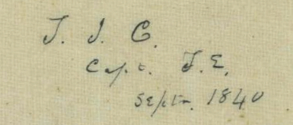
Transcribed, the note reads: “T. J. C. / Capt. T. E. / Septr. 1840” or, more fully, “T. J. Cram, Captain, Topographical Engineers, September 1840.” So who was T. J. Cram?
Thomas Jefferson Cram was born in New Hampshire in 1808. He served with the U.S. Army’s Corps of Topographical Engineers from 1839 to 1863, and with the U.S. Army Corps of Engineers from 1863-1869. He had a remarkable and highly productive career with the Army, including important assignments surveying and drawing maps, building roads, and improving harbors in Wisconsin Territory, the Great Lakes, along the Atlantic Coast and on the Ohio and Mississippi Rivers, and in Mexico during the 1848 war. He died in Philadelphia in 1883.4
Taking a (brief) closer look
This is another map that pays dividends with a closer look. As always here at CHH, I recommend clicking on each image—especially the maps—which will open a new window with a higher-resolution and more detailed version of the item. For the original map, click the image above. For further information, click the map below, with my annotations added in blue type

You’ll notice our map is strikingly similar to a map we discussed earlier, the Topographical map of Wisconsin Territory / compiled from the Public Surveys on file in the Surveyor General’s office … by Samuel Morrison, Elisha Dwelle [and] Joshua Hathawaym engraved by Doolittle & Munson and published in 1837. Both these maps cover only those parts of Wisconsin Territory that were originally open to white settlement, namely everything north of Illinois, east of the Mississippi River, and south of a diagonal line running from Fort Howard (Green Bay) in the northeast thence southwest up the Fox River to Ft. Winnebago (now Portage, in the big blue circle) and then down the Wisconsin River to Ft. Crawford at Prairie du Chien.
The federal roads that had been cut and were in operation in 1840 are drawn in red. Many of these had been important Native American trails for many centuries. One of these, and the most important for our early Mequon settlers, was (and still is) known as the Green Bay Road. It ran north-to-south, from Ft. Dearborn in Chicago to Ft. Howard (Green Bay). Its course roughly paralleled the shoreline of Lake Michigan and passed through many of the most important early settlements.
During his military service at Fort Howard, Jonathan M. Clark was among the soldiers assigned to build the “Military Road” that eventually connected Forts Howard, Winnebago and Crawford. In the summer and fall of 1835 and 1836, JMC worked on the portion of the Military Road that began at Fort Howard and would eventually make its way around the south shore of Lake Winnebago at Fond du Lac, and then to the portage at Ft. Winnebago.
Another very early federal road and bridge project in Wisconsin Territory was the road connecting Port Washington (called Sauk Harbor on this map) on Lake Michigan, to Dekorra (also in the big blue circle), on the Wisconsin River, to the west. One of old Washington/Ozaukee county’s earliest villages was established where this east-west road crosses the Milwaukee River and intersects with the Green Bay Road; that village is still known as Saukville.
Other east-west roads on our 1840 map include the road from the Territory’s most important population and commercial center, Milwaukee to the state capital at Madison. Further south, another federal road connected Lake Michigan to the Mississippi River, running inland from the port village of Racine to Janesville on the Rock River and then to the once-thriving lead region settlement of Sinnipee. (Sinnipee no longer exists. It was flooded in 1934 to make way for Mississippi River Lock and Dam No. 11.)
Coming up
I hope you enjoyed our map today, with its unique record of the federal roads that had been constructed in the first four years of pioneer settlement in the Wisconsin Territory. FYI, the Green Bay Road passes near the Jonathan Clark House and it will play an important role in some of our upcoming CHH investigations. If you’re not yet Green Bay Road savvy, be sure to scroll down to Note no. 1, below, and click the links to some related—and lavishly illustrated!—CHH essays from past years.
In our next post, we’ll look at another related document from NARA’s collection of maps and drawings created by the Corps of Topographical Engineers and then…surprises!
See you soon with more Clark House History.
Postscript: a few notes on NARA
As the official repository of the records of the United States federal government, it’s probably not much of a surprise that NARA, the National Archives and Records Administration, has an immense collection of documents, maps, images, and other records of our nation’s history. Among other duties…
The National Archives administers 15 Presidential Libraries and Museums, a museum in Washington, D.C. that displays the Charters of Freedom, and 15 research facilities across the country. The agency’s online catalog makes available over 160 million records ranging from before the start of the republic to the modern government. However, the digitized records represent only a small fraction of the over 13 billion pages in the holdings of the National Archives.5
NARA’s holdings are, in fact, almost indescribably vast.
Archival descriptions of the permanent holdings of the federal government in the custody of NARA are stored in the National Archives Catalog. The archival descriptions include information on traditional paper holdings, electronic records, and artifacts. As of December 2012, the catalog consisted of about 10 billion logical data records describing 527,000 artifacts and encompassing 81% of NARA’s records. There are also 922,000 digital copies of already digitized materials.6
Yes, that’s billion with a “B.” Note that these statistics, accessed in 2024, are actually a dozen years out-of-date. In the intervening years NARA’s holdings have continued to grow, and their digitization and online catalog search have improved considerably.
_______________________________________________
NOTES:
- Road building was one of the most important tasks taken on by federal and local governments in the early years of white settlement in Wisconsin Territory, and old Washington/Ozaukee county was no exception. I’ve written and published many posts on the topic here at Clark House Historian. If you are interested knowing more, let me recommend the following, for starters:
• County Government – Early Records
• Monday: Map Day! – The First County Roads, 1841
• Marking out the roads
• Roads into the Woods, 1841
• Another Road into the Woods, 1841
• The county’s earliest federal roads (plural)
• a short item on JMC and a local plank road in: Working at Home
• and on a general, road-related note: How’d they get here? Walking & riding - NARA’s online catalog interface and search process have improved over the years, but are still not particularly intuitive or user-friendly. Just searching for an item by its title may get you thousands of additional, non-relevant results. So knowing the Record Group, Series, and File Unit for an item will make it much easier to retrieve on future visits to NARA online.
- I believe Capt. Cram and his colleagues in the Topographical Engineers created this and several other area maps as part of Cram’s work as superintendent of federal roads in Wisconsin Territory. We will take a look at another of these Wisconsin Territory documents from the Topographical Engineers in our next post.
- The Topographical Engineers were considered an elite unit in their day, filled with some of the Army’s best and brightest (and most intrepid) officers. If you’d like to know more about the T.E. Corps and their remarkable history, this article gives a good overview.
For more on T. J. Cram’s life and work with the Topographical Engineers, see his Wikipedia entry. It’s very informative, and includes links to many references. One of these is particularly interesting, an army publication titled The Nation Builders: A Sesquicentennial History of the Corps of Topographical Engineers, 1828-1863, edited by Frank N. Schubert, published by the Office of History, U.S. Army Corps of Engineers, Fort Belvoir, Virginia, 1988. It includes information on Cram and his work in Wisconsin, and many details of how the Corps accomplished its many tasks. The Nation Builders is available as a free PDF, but a working link to the paper is not always easy to find. So I have added a copy of document to our Clark House Historian blog media files; if you’d like a copy, please click here to view and download a free PDF of this interesting history (88 pages, about 8.1 MB in size). - Wikipedia, subject “National Archives and Records Administration,” section “Organization,” accessed 6 April 2024.
- Wikipedia, subject “National Archives and Records Administration,” section “Records,” accessed 6 April 2024.

Love that 1840 map!
Nina
LikeLike
Me too! It was a happy find while I was looking for something else at NARA. —Reed.
LikeLike
Pingback: JMC, the Army, and the Military Road, 1835-1840 | Clark House Historian
Pingback: The Green Bay-to-Chicago and other federal roads, c. 1840 | Clark House Historian
Pingback: Lost in the underbrush… | Clark House Historian