Well, the big day is just a week away. Here at Clark House Historian I try and remain officially non-partisan. But as a researcher and writer, and as an American with long, deep, roots in this country, I have a passionate interest in our nation and its history, and a life-long desire to see us live up to our highest ideals and aspirations. (Of course, human nature being what it is, we have not always lived up to those ideals.)
So with the election approaching, today’s post takes a look at the political leanings of early Washington County and—after its establishment in 1853—Ozaukee County, with an emphasis on presidential elections from 1848 to 1880. Our main source today is the invaluable History of Washington and Ozaukee counties, Wisconsin […], published in Chicago in 1881. Let’s begin with some of the earliest results, following statehood in early 1848:
We’re on the hunt for the family and birthplace of Jonathan M. Clark. For background, start here. You’ll notice that we have conflicting claims for Jonathan M. Clark’s birthplace, namely: • Derby, Orleans County, Vermont, USA and, across the border to the north, • Stanstead County, Lower Canada (now Province of Quebec, Canada)
There is a lot to learn and discuss about both places. The histories of Vermont and of Lower Canada are complex and interesting and it’s easy to get distracted by background documents and a multitude of historical events of all kinds.
I want to break things down into smaller bits, and take one topic at a time. We will have much to say about Vermont in upcoming posts. Today, I’d like to steer you to one of the earliest and still most comprehensive published histories and genealogies of Stanstead County, Province of Quebec:
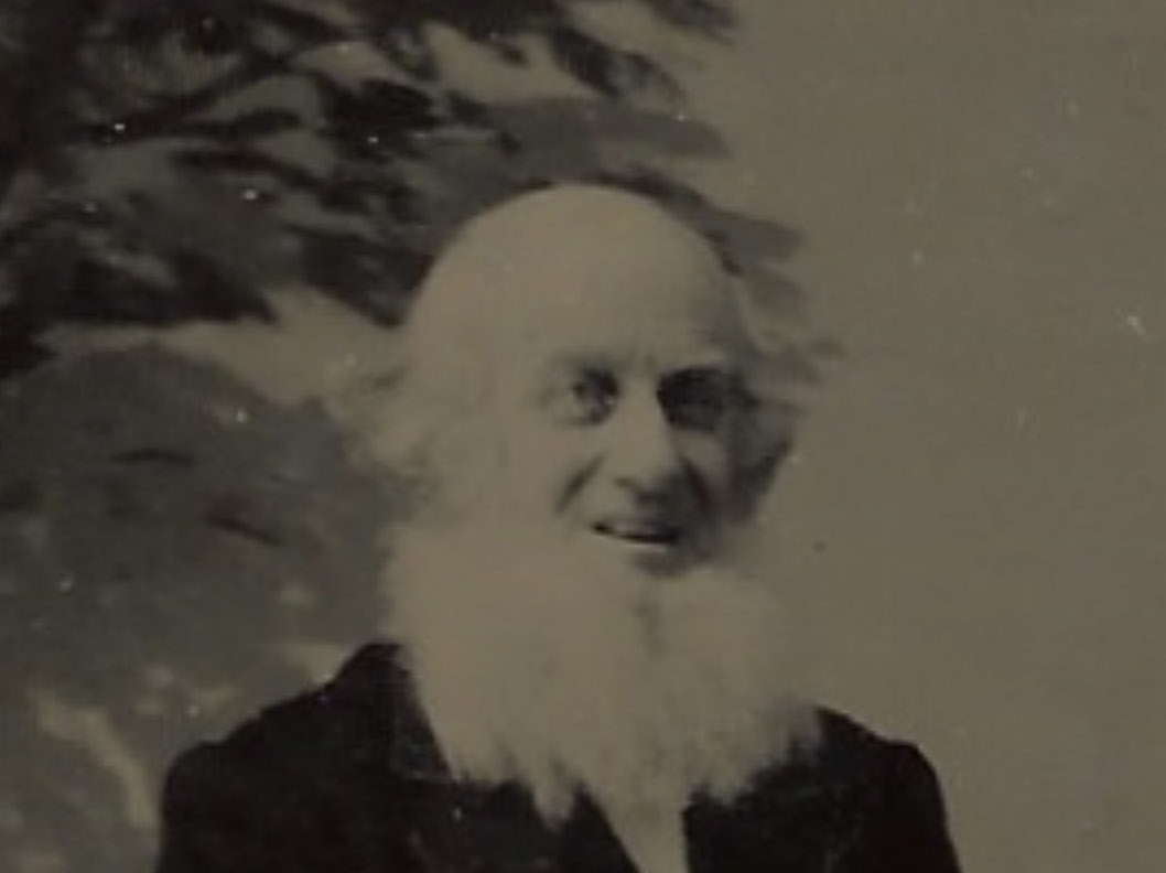
Cyrus Clark (tintype, detail). Photo courtesy Steven Clark Van Slyke. Click to open image in new window.
Dating and interpreting old photographs, part 3 of 4
For our next to last look at photographs from the family of early Mequon settlers Cyrus and Sarah (Strickland) Clark we’ll start to take a closer look at three images made with another popular photographic process from the era, the tintype. We will examine the clothing, props, backgrounds and other aspects of the photographs, learn more about the tintype process, and try and determine when the photos were taken1. Once again, thanks to Clark and Strickland descendants Steven Clark Van Slyke and Lynnette Thompson for the photos and family history assistance.
If you’re new to the discussion, I recommend you read our previous post, Cyrus Clark’s Cabinet Card, and click the links there for additional background on the family and the other Clark portraits. To begin, let’s take a quick look at all three of our Cyrus Clark tintypes:
Today we take another dive into photo research and dating, as part of our look into the lives of Cyrus Clark and Sarah Strickland Clark (here, here, here, here and here). Thanks again to Clark and Strickland descendants Steven Clark Van Slyke and Lynnette Thompson. Without further ado, here is part two of our initial Clark House Historian attempt at analyzing historic photos1.
Let’s start with the photo of Cyrus that we’ve used on our previous Cyrus and Sarah posts. Here’s the front:
This week we take a break from our usual focus on the extended Jonathan M. and Mary (Turck) Clark family and begin a week of posts about two remarkable, original Mequon settlers and Clark House neighbors: Sarah Allise Strickland (1823-1891) and her husband, Cyrus Clark (1815-1905).
Sarah A. Strickland was born and raised in Nova Scotia, the eldest child of Daniel and Matilda Strickland. Her family was one of the original white settler families in the area; they were enumerated in Milwaukee County on Wisconsin’s first territorial census in 1836.1
Cyrus Clark was born in western Massachusetts and was in Mequon by about 1839. He married Sarah Strickland in Grafton, Washington (later Ozaukee) County, on March 1, 1841. They lived almost forty years in Wisconsin. First in Mequon and Cedarburg, Washington/Ozaukee) County, and then divided their time between their farm in Moscow, Iowa County, and homes of one or more adult children in Oshkosh, Winnebago County. So how—and why—did they end up in South Dakota at the end of their days?
It’s an interesting story, and one that illustrates a characteristic type of pioneer experience: the continued drive to push westward, on to new frontiers and new challenges. It may seem cliché to us, but it was a real, lived experience for many of Cyrus and Sarah’s generation. This week’s posts will look at a number of key moments in their long lives, especially the decades they spent in Wisconsin. And we have some unique and new sources to share, too.
Beginning at the end…
Click to open larger image in new window.
Gravestones of Cyrus Clark and Sarah A. (Strickland) Clark, Graceland Cemetery, Madison, South Dakota. Photo by Steve Van Slyke, used by permission.
We begin the story of Cyrus and Sarah Clark at the end, in Lake County, South Dakota, their final resting place. And not one, but two maps today, all of which take us far from Mequon and the Jonathan M. Clark house.
UPDATED February 9 & 11, 2025, to correct the year and date of Fred. Beckmann’s death and investigate the apparent errors on his gravestone (see updated images, text, and especially Note 4, below).
Farming the Clark place, 1868-1873
In our previous post we saw that sometime around 1861/62, Mary Clark and her children decided to move to Milwaukee. By the time the MilwaukeeCity Directory for 1862 was published, Mary—and, we presume, her children—were living together with Mary’s father Peter Turck, at 474 Jefferson in the city.
We also know that Mary and her daughters did not sell the Mequon farm—to Catherine Doyle—until April, 1872. So, for over a decade, someone besides the Clark family was living and working on the Clark property. Most likely, Mary made some kind of tenant-farmer arrangement where someone grew crops on the Clark land and paid rent to Mary from the proceeds. This could have been a very useful source of income for Widow Clark and her seven children during the 1860s. Unfortunately, we don’t have much documentation of who the tenants may have been and what sort of arrangement Mary may have made with them.
The Doyle Family
In the same post, I also erred in assuming that the John and Catherine Doyle family probably farmed the Clark land throughout the 1860s. Clark House museum director Nina Look recently called my attention to information about the Doyles and their neighbors in various maps and census schedules created around 1870 that shows that the Doyles were living and farming elsewhere in Mequon through most of the 1860-1870 decade. In future posts I will look at those maps and census schedules and try and make more sense of where the Doyles lived and what land they may have farmed prior to purchasing the Clark farm in April, 1872.
Nina also reminded me that I forgot one important person that we know did farm the Clark farm: Fred Beckmann
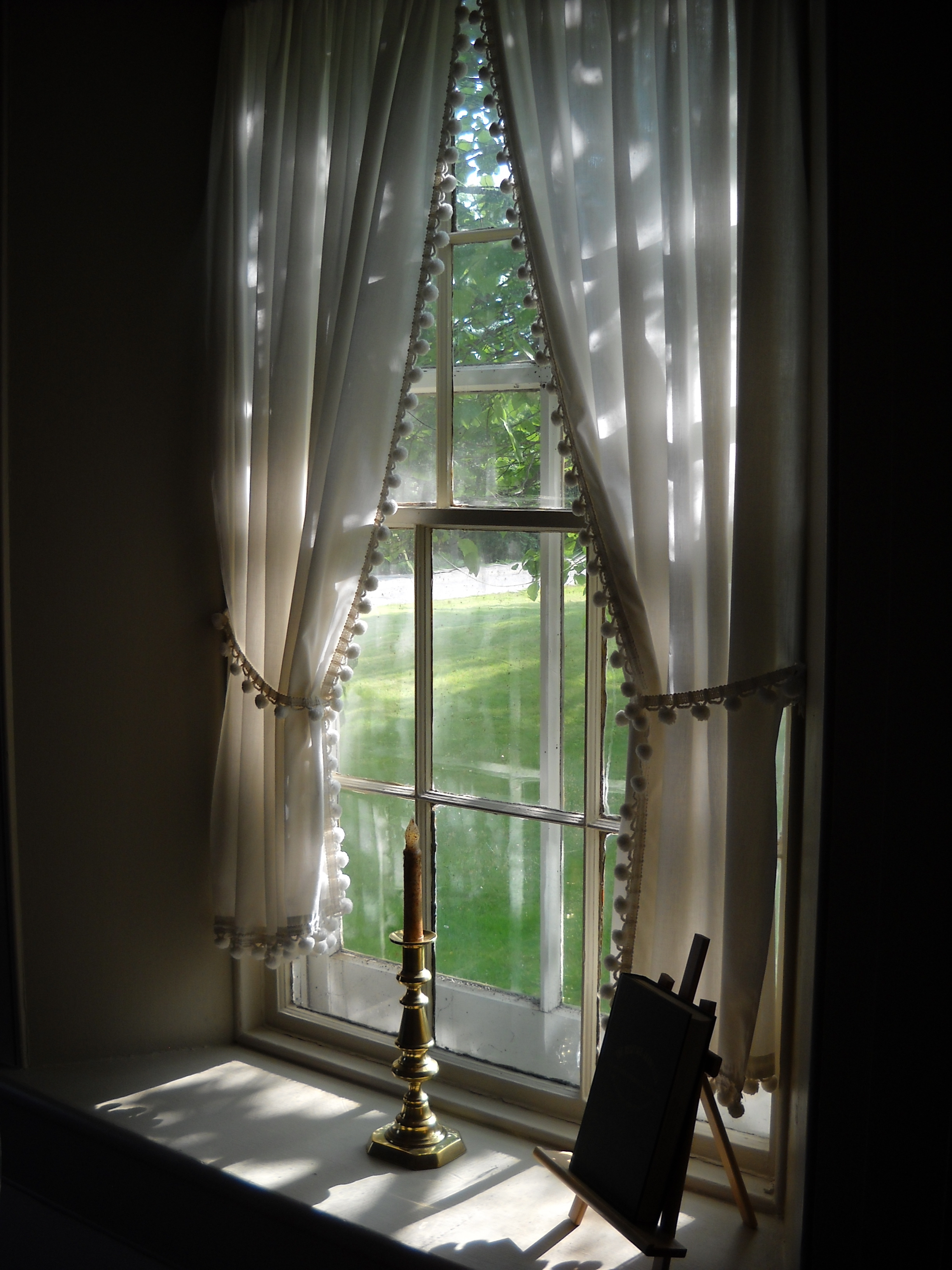
There’s a lot going on behind the scenes at Clark House Historian these days. I’ve got a half-dozen blog posts in various stages of completion, plus ongoing research and information-checking projects with Nina Look, Liz Hickman, and others. And, I’ve just heard from a third-great-granddaughter of two of the original Mequon settler families! How cool is that? More on those folks in an upcoming post—or two!
So let’s take a break, and enjoy a relaxing summer view from the Clark House. In this instance, a lovely July, 2015, view from the Clark’s front parlour, looking to the southwest toward present-day Bonniwell Road. According to the 1872 “Shoolmap” of Mequon, neighbors John Kurz and J. H. Townsend lived just across the street. A bit farther west down the road were—still—the farms of old friends and original Mequon settlers William Bonniwell and Jesse Hubbard.
Photo by Anna Perkins, used by permission. Click to open larger image in new window.
Today’s Monday: Map Day! introduces a rare and very interesting map, from a wonderful digital collection of maps. It’s the c. 1872 “SHOOLMAP of the TOWN of MEQUON,” from the University of Wisconsin–Milwaukee’s American Geographical Society Digital Map Collection, and it is packed with information and unique details:
To view a beautiful, large version of today’s map, click here, or on the map image (above). That will open a new window and take you to the University of Wisconsin–Milwaukee’s American Geographical Society Digital Map Collection, and the home page of this map. It will look something like this:
“Constant vigilance!” — J. K. Rowling, Harry Potter and the Goblet of Fire
Mad Eye Moody’s advice to the Hogwarts students was essential for them and remains apt for anyone doing historical research. Whether working on a large history project or a modest family tree, constant vigilance is needed to avoid bad information. Fortunately, the historian or genealogist’s dementors are not deadly wraiths ready to suck the life force from us, but more mundane creatures such as typos, inaccessible or hard-to-read documents, and—most vexingly—mystery data.
For some reason, in my database I had recorded that Jonathan and Mary Clark’s sixth child, daughter Laura, had a middle name of “Mandlena.” This—unless I’ve overlooked some important but now lost evidence—was nonsense. It’s the sort of mistake that creeps into historical writing via random error; I don’t know how I managed to make this particular honker. So for the record, the Clark’s sixth child was Laura Marcelleau Clark.
Jonathan M. Clark married Mary Turck in old Washington county—possibly in Mequon—Wisconsin on March 15, 1840, and their daughter Caroline was born almost eight months later, on November 7, 1840. Caroline was the first of eight Clark children, one born about every two or three years between 1840 and 1857: Continue reading →