The Green Bay-to-Chicago and other federal roads, c. 1840

Time for one more follow-up to our recent posts Monday: Map Day! – Wisconsin’s Federal Roads in 1840 and JMC, the Army, and the Military Road, 1835-1840. As I mentioned in that “Monday: Map Day!” post, I recently found some unique maps and related documents in the digitized collections of the National Archives and Records Administration (NARA), in particular a group of maps and drawings created in 1840 by members of the army’s Corps of Topographical Engineers under the supervision of Capt. T. J. Cram.

Before they get lost in my files, I thought I’d share the other documents from Capt. Cram’s 1840 survey that have survived and been digitized by NARA. I’ve already said quite a bit about these 1840 maps and drawings; now I’m most interested in gathering the remaining 1840 documents and their bibliographic citations here for reference. So not much commentary today, but lots of images. And—as always—I recommend clicking on each item to open a larger, higher-resolution image in a new window.

Bridges on the Green Bay Road

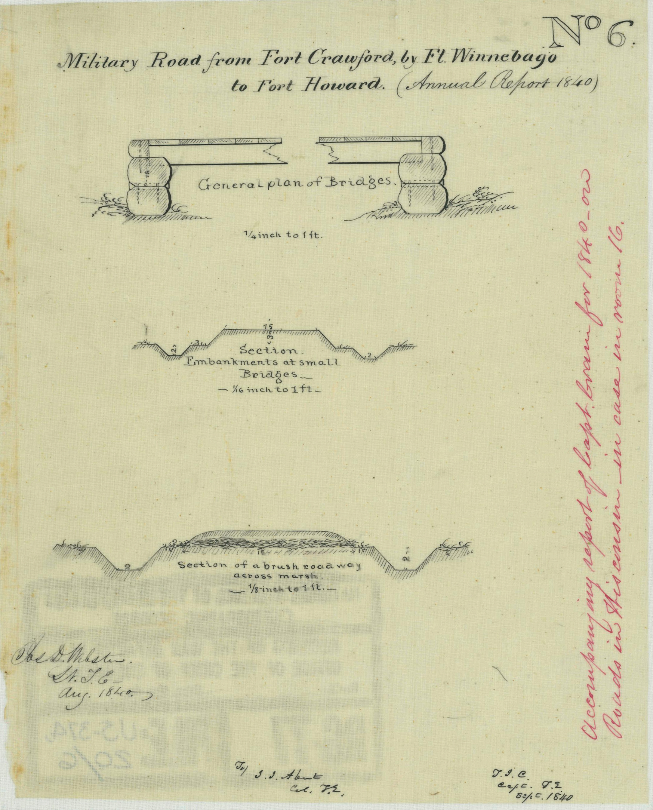
The first item is of particular interest for Clark House history fans, as it provides additional details about old Washington/Ozaukee county’s first federal road, the north-south route connecting Fort Dearborn, Chicago, to Fort Howard at Green Bay. The drawing is part of a larger document; this portion is titled “Road from Ft. Howard, by Milwaukee & Racine, to the Northern boundary of Illinois.”

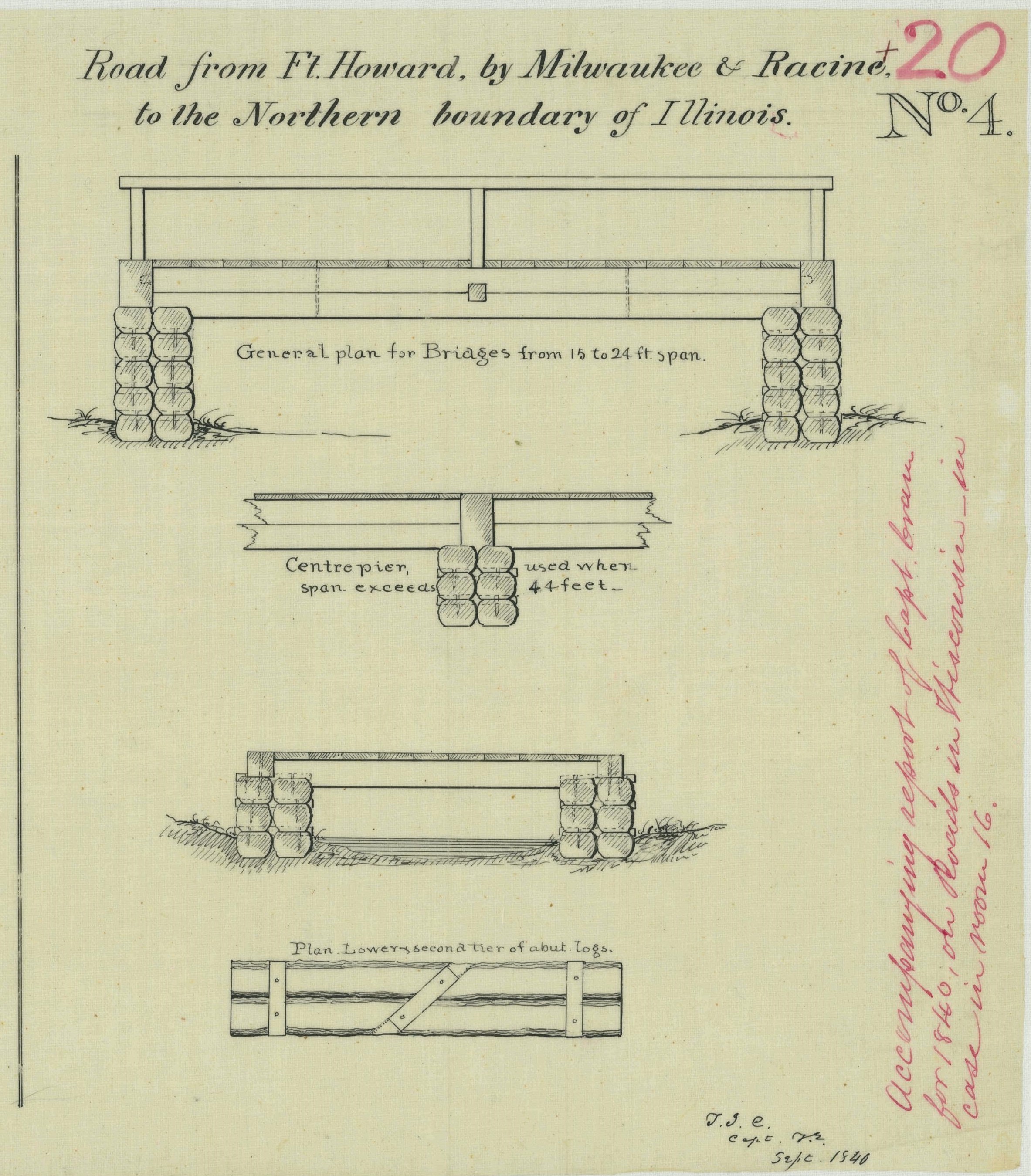
NARA, full citation, below.

The drawing illustrates construction details of the simple wooden bridges that were part of the Green Bay Road, circa 1840. This road, and these bridges, comprised the main north-south transportation route for the U.S. Mail and for immigrants and settlers of the new counties of southeast Wisconsin Territory. The Clarks, Turcks, Bonniwells and other early Mequon pioneers would have crossed bridges like these on their trips to and from Milwaukee, Grafton, Port Washington and beyond on the Green Bay Road.

And that’s not all…

Continue reading

JMC, the Army, and the Military Road, 1835-1840

Today’s post is a follow-up to our recent Monday: Map Day! – Wisconsin’s Federal Roads in 1840. It features another document created by the U.S. Army’s Corps of Topographical Engineers and preserved in the collections of the National Archives and Records Administration. Today’s drawing interests us as it documents—in some detail—the kind of road building work that Pvt. (later Sgt.) Jonathan M. Clark performed as a member of Company K, 5th Regiment, U.S. Infantry.

Webster, Jos. D, et. al., “Military Road from Fort Crawford to Fort Winnebago to Fort Howard (Wisconsin),” NARA, Record Group 77: Records of the Office of the Chief of Engineers, Series: Civil Works Map File, File Unit: United States, accessed here, April 14, 2024.

This document interests us because after JMC left the army he, with many of his early Mequon neighbors, spent a good part of the 1840s surveying, cutting, clearing, and grubbing out some of old Washington/Ozaukee county’s earliest roads. In the process, these pioneers had to bridge streams and rivers of various sizes and depths, and find ways to keep the unpaved roadway dry and firm. How did they do it with the limited supplies and tools at hand?

Today’s document shows how the U.S. Army solved some of those issues a bit farther north, on Wisconsin’s east-west Military Road. The techniques and approaches to road construction use there may have influenced how JMC and our early county road builders solved the problems of building roads in the forests, wetlands, and open prairies of 1840s Washington county.

Continue reading

Monday: Map Day! – Wisconsin’s Federal Roads in 1840

I spent much of January and February preparing my March 9th, 2024, Civil War presentation at the Cedarburg History Museum. In that talk I tried to take a more personal and local look at the war by examining the military service of few of the Cedarburg relatives and future in-laws of 1868-1873 Clark House resident Fred Beckmann. In my research, I found some unique stories of their years of Union service in the 9th and 26th Wisconsin Infantry Regiments, as well as the impact of the war on families and friends back home in Wisconsin.

I also found several new online collections of unique maps and historical documents. Today’s map is from one of those online sources, the digitized map collection of the National Archives and Records Administration (more on NARA and its holdings, below). This map was made 20 years before the Civil War, in September, 1840, and is one of the earliest—if not the earliest—maps of the federal roads in Wisconsin Territory.1

U.S. Roads in Wisconsin Territory, 1840

Continue reading

I’m deep in documents…

…as I prepare my March 9th Civil War presentation for the Cedarburg History Museum, try to sort out the full story of Mequon-Thiensville’s earliest settlers and landowners (including first postmaster John Weston), and look through a bushel of fresh sources in our ongoing search for Jonathan Clark’s kin who hail, we think, from somewhere up around where Derby, Vermont meets Stanstead, Québec.

The Clark House Historian and his crack research team, searching for answers in the written record…1

As you can see, I’ve got work to do in order to dig out from under—and make sense of—the big pile of historical documents that I’ve accumulated over the past several weeks.

So no new CHH post today, but I’ll be back soon with more Clark House history.

Continue reading

RBOH: Weston & Western, Loomis & Loomer, and how do you pronounce Isham?

Time for a few Random Bits of History: Early Mequon Settlers’ Disambiguation Edition.

John Weston & John Western

Mequon’s first postmaster, John Weston, is mentioned many times in the essential local history book, the History of Washington and Ozaukee Counties, Wisconsin … Illustrated. Western Historical Publishing Co., Chicago, 1881. Using the “Find” function on my PDF copy of the book,1 I found results for “John Weston” on pages 475, 476, 523, 524 and 545.

There is also an entry for “T. Weston” among the names on the “First Poll-List of Washington County” on page 316. I am confident that this is a typographical error and that “T. Weston” is actually John Weston.

The same source also records, among the early area settlers, one “John Western,” on pages 316, 477 and 478. Is this the same man as John Weston? I have carefully compared a number of sources, including the early minutes of the county road supervisors and deeds in the Washington/Ozaukee county deed books, and I am convinced that during the early years of settlement in the Mequon-Milwaukee area, “John Weston” and “John Western” are the same person, namely John Weston, born in New York about 1800, and married to Deborah Milliner in Milwaukee County in April, 1838. I’ll have examples from the documents that explain my reasoning in a future post.

Fun fact: Mary (Turck) Clark’s father, (Baptist) “Elder” Peter Turck, was the officiant at the Weston-Milliner wedding in 1838. It was the fortieth marriage recorded in the first volume of marriage records for Milwaukee county (and its still-attached for judicial purposes neighbor counties, including old Washington/Ozaukee county).2

With the Weston & Western mystery solved—for the moment—let’s see what other bits of error and confusion we can clear up…

Continue reading

Meet the neighbors: the Loomis family

I’m in the middle of several larger CHH research projects and I find myself swamped with information on early Mequon area pioneers. So rather than wait until I’ve got it all sorted out and then organize it into a big essay or two (or more!), I’ll be putting up some of these new bits and pieces on the blog as I find them.

Today’s subjects are the families of Jonathan Loomis (1776-1849) and his eldest child, Issac Chester Loomis (1802-1882), two of old Washington/Ozaukee county’s first white settler families. I’ve mentioned some of these folks in previous CHH posts. And while the Loomis name does appear in some of the early county histories and land records, so far I’d not been able to learn much about the family or how they came to the Wisconsin Territory in the 1830s. In fact, given that the mid-1800s penmanship on some of the source documents was often florid to the point of being unreadable, I was sometimes unsure whether documents discussing or signed by “J. Loomis” versus “I. Loomis” represented the same man, or two individuals. Today’s source goes a long way toward solving these questions.1

Descendants of Joseph Loomis in America

Loomis, Elias, and Charles Arthur Hoppin. Descendants of Joseph Loomis in America, and his antecedents in the old world. edited by Loomis, Elisha S [Berea? O, 1909], Library of Congress.

As luck would have it, I just ran across a useful digitized book in the collection of the Library of Congress, titled Descendants of Joseph Loomis in America, and his antecedents in the old world. I’m not an expert in Loomis genealogy, and thus not entirely sure how accurate this book is, but what I have read here mostly checks out when compared to what I have found elsewhere. With that said, below are the key bits of the book that are related to very early Washington/Ozaukee county history and, in particular, Isaac Chester Loomis and his family. What follows is taken verbatim from pages 193 and 390-391, though I’ve taken the liberty of expanding many of the abbreviations and adding a few paragraph breaks for ease of reading. I’ve also added a few footnotes to explain some possibly obscure references.

Let’s begin with the patriarch of the family, Jonathan Loomis…

Continue reading

Old Washington/Ozaukee county’s first postmasters, 1837-1844

I’m working on a subject suggested by my friends Sam Cutler and Bob Blazich from the Mequon-Thiensville Historical Society. Among other projects over the last few decades, they and their colleagues at the MTHS have restored what is believed to be Ozaukee county’s oldest building on its original foundation, the historic Isham Day house, and developed its interior into the Mequon River Postal Museum. Now my friends at the MTHS want to know more about the life of Mequon River Post Office’s original postmaster, one of Mequon’s very first pioneer settlers, John Weston.

Isham Day house, exterior, west front. Photo credit: Anna Perkins, 2021

So for the last several weeks I’ve been doing a great deal of behind-the-scenes reading and re-reading of primary and secondary sources, as well as a lot of searching for additional relevant documents, including early Milwaukee and Washington/Ozaukee county deeds and other land records. In the process, I’m learning a lot about John Weston, Isham Day, Henry Thien, and some of our other first white settlers. But I’m not quite ready to write a John Weston profile, and I still need to clear up some mysteries about Isham Day’s land and house, too.

First Postmaster(s)

New post office…at Mequan River…John Weston appointed postmaster, Milwaukee Advertiser, Oct. 10, 1840, page 2

Let’s get our bearings by making an accurate list of the county’s first postmasters and their terms of office. Our source is from the National Archives in Washington, DC, the Record of Appointment of Postmasters, 1832-Sept. 30, 1971; Records of the Post Office Department; Record Group Number: 28; Series: M841; Roll Number: 144. County: Polk – Wood, Vol. 12B, circa 1832-1844, pages 794-795, currently available via Ancestry.com as U.S., Appointments of U. S. Postmasters, 1832-1971 [database on-line], 2010, image 428 of 583 (accessed 18 Jan 2024). Here’s the microfilmed image of the two-page ledger recording Washington county’s first post offices and postmasters, slightly retouched to make for easier reading:

Click the image for a higher-resolution view, and then read on for more details about old Washington/Ozaukee county’s first two post offices and their original postmasters.

Continue reading

Happy New Year, 1848

1848 was a big year for Jonathan and Mary (Turck) Clark. Their family now included four children: Caroline (b. 1840), Henry (b. 1843), Libbie (b. 1845) and infant daughter Persie (b. 1847). And 1848 was the date that Jonathan M. Clark inscribed—just below his own name—on the Clark House “cornerstone” that still decorates the lintel above the Clark House front (south) door.

Photo credit: Reed Perkins, 2015

1848 was a landmark year in many respects. Gold was discovered in California, the War with Mexico ended with the Treaty of Guadelupe Hidalgo and, most importantly for our Mequon pioneers, the Wisconsin Territory adopted a state constitution and was admitted by act of Congress as the 30th state in the Union.

Of course, on January 1, 1848, those events—and many others—still lay in the future, in the New Year. We’ve blogged about some of those events here at Clark House Historian, and we’ll have more to say about other 1848 events in the future. But did you ever wonder how our Mequon settlers observed the change from one year to the next during the 1840s and 1850s?

Continue reading

Home to Thanksgiving

It’s Thanksgiving tomorrow, and I’m taking a few days off to spend time with family. But in the spirit of the holiday, I thought I’d reprint a lightly revised version of our now-annual Thanksgiving post, to share with you a few vintage recipes and a nice Currier & Ives lithograph from the period.1

Thanksgiving, 1867

Durrie, George H. and John Schutler, Home to Thanksgiving, ca. 1867, New York, Currier & Ives. National Gallery of Art, Collection of Mr. and Mrs. Paul Mellon. Public Domain. Click to to open larger image in a new window.

Continue reading

Finding JMC’s roots: Vintage first names puzzle

No new research today. I’m celebrating a big event with family, and taking a few days off from emails and major blog posts while I do.

“They just don’t name ’em like they used to…”

I’m loath to leave loyal blog readers without some Clark House History to while away the time until our next big CHH post, so I made another word search puzzle.

Your assignment today is to find the vintage Stanstead-area settler first names, all of which are documented from Clark-era sources in and around Stanstead, Lower Canada, circa 1790-1840, and many of which will feature in future posts as we search for JMC’s roots.

As in our previous post, just click the image to open and print your own copies of this version of the puzzle. Or, if you’d like to play online, just click this link: https://thewordsearch.com/puzzle/6173938/stanstead-first-names-c-1790-1840/

Continue reading