We’ve had some snow in my corner of southeastern Wisconsin, several modest snowfalls over the past few days. I’ve had to shovel the walks and driveway at our house a few times this week, and there’s more snow—and shoveling—in the forecast. With that in mind, I thought you might enjoy the snow-related images and stories from a revised edition of this post, which originally appeared here in February, 2023.
Homer, Winslow, A Winter-Morning,—Shovelling Out, 1871. Wood engraving. Brooklyn Museum, Gift of Harvey Isbitts.
Winter chores
I empathize with the lads in this 1871 engraving by Winslow Homer. Unlike these fellows, with their (homemade?) wooden shovels, I have a lightweight, sturdy, ergonomic, plastic and metal snow shovel to work with. And although we do get snow in 21st-century Wisconsin, I haven’t had to deal with shoulder-high accumulations like the ones in Homer’s picture since I lived in western Massachusetts in the early 2010s. It looks like our 1871 snow shovelers are dealing with the kind of snowfall that Clark family neighbor Rev. James W. Woodworth described in these January, 1871, diary entries:
Saturday, March 1, 2025, from 9:00 am to Noon, the Jonathan Clark House Museum, at the corner of Bonniwell and Cedarburg Roads in Mequon, will host a special museum open house featuring an up-close exploration of our newly-acquired 1860 Plat Map of Mequon.
Happy New Year to all, and best wishes for an excellent 2025. I thought we’d start the year with a lightly edited re-post of an earlier CHH essay about a cheerful, festive song, one that may have been familiar to our Mequon settlers in the 1840s.1
A spot of Spofforth to ring in the New Year…
Our New Year’s sing-along number is “Hail Smiling morn” by the English composer Reginald Spofforth (1769-1827), a vocal quartet featured in the second part of the Milwaukee Beethoven Society’s March 23rd, 1843, premiere concert:
Milwaukee Weekly Sentinel March 15 1843, page 2. Click to open larger image in new window.
Spofforth was a man of many talents, but was particularly known for his glees. A glee is a kind of convivial part-song, typically for three or more voices and usually—but not always—sung without accompaniment. I’ll have more to say about this particular composer and piece later, but for now, it’s well enough to know that “Hail Smiling morn” is—according to musicologist Nicholas Temperly—”possibly the most popular glee in the entire repertory,” and that’s saying something!
Tonight is Christmas Eve, and I thought you might enjoy an expanded reprise of our 1867 Santa Claus story, originally posted in two parts, December 25 and 30, 2017. In 2021 I combined the two original posts and incorporated some new illustrations and a few revisions of the text. Here it is again, for your holiday enjoyment. Ho! Ho! Ho!
Christmas in early America
For many years now, Christmas has been celebrated by Americans as an important religious and (increasingly secular) community holiday. Christians gather to worship and commemorate the birth of Jesus, and they and other Americans enjoy a break from work to gather with family and friends to feast and exchange gifts. But it was not always this way.
In many of the American colonies, Christmas was not observed as a religious or secular holiday. The seventeenth-century Puritan leaders of the Massachusetts Bay Colony considered Christmas to be non-biblical and pagan influenced. In Boston and other parts of New England any observance of Christmas was prohibited and, for a few years, actually illegal:
Penalty for Keeping Christmas, 1659
Records of the Governor and Company of the Massachusetts Bay in New England. Printed by order of the Legislature, edited by Nathaniel B. Shurtleff, M.D., Vol. IV, Part I, 1650-1660, online at mass.gov (accessed 21 Dec. 2021). Click to open larger image in new window.
Transcription: For preventing disorders arising in several places within this jurisdiction, by reason of some still observing such festivals as were superstitiously kept in other countries, to the great dishonor of God and offence of others, it is therefore ordered by this Court and the authority thereof, that whosoever shall be found observing any such day as Christmas or the like, either by forbearing of labor, feasting, or any other way, upon such accounts as aforesaid, every such person so offending shall pay for every such offence five shillings, as a fine to the country.
Christmas was not generally accepted as a holiday in many parts of the United States until after the federal government made December 25 a national holiday in 1870.
On the other hand…
The Massachusetts Puritans may not have approved of “observing any such day as Christmas or the like, either by forbearing of labor, feasting, or any other way,” but Christmas was “kept in other countries” and increasing numbers of immigrants from those countries to the United States—particularly from Victorian England, Catholic Europe, and the German Lands—celebrated the day in their new American homes with many of their accustomed religious observances and national traditions.
Well, whaddya know? Christmas is just around the corner…
JCH Parlour with Christmas tree and decor. Photo credit Reed Perkins
Holiday Lights 2024
December 2 & 3, 2024, brought us the latest edition of our Holiday Lights gathering of Clark house friends old and new. There was good food, tasty beverages, lively conversation, and fine seasonal music, all dished up in the unique ambience of our historic Jonathan Clark House Museum.
As we do every year, the house was decorated with appropriate 1840s-style decorations, including the table-top Christmas tree and ornaments, and the evergreen bough decorations on the window sills, shown above.
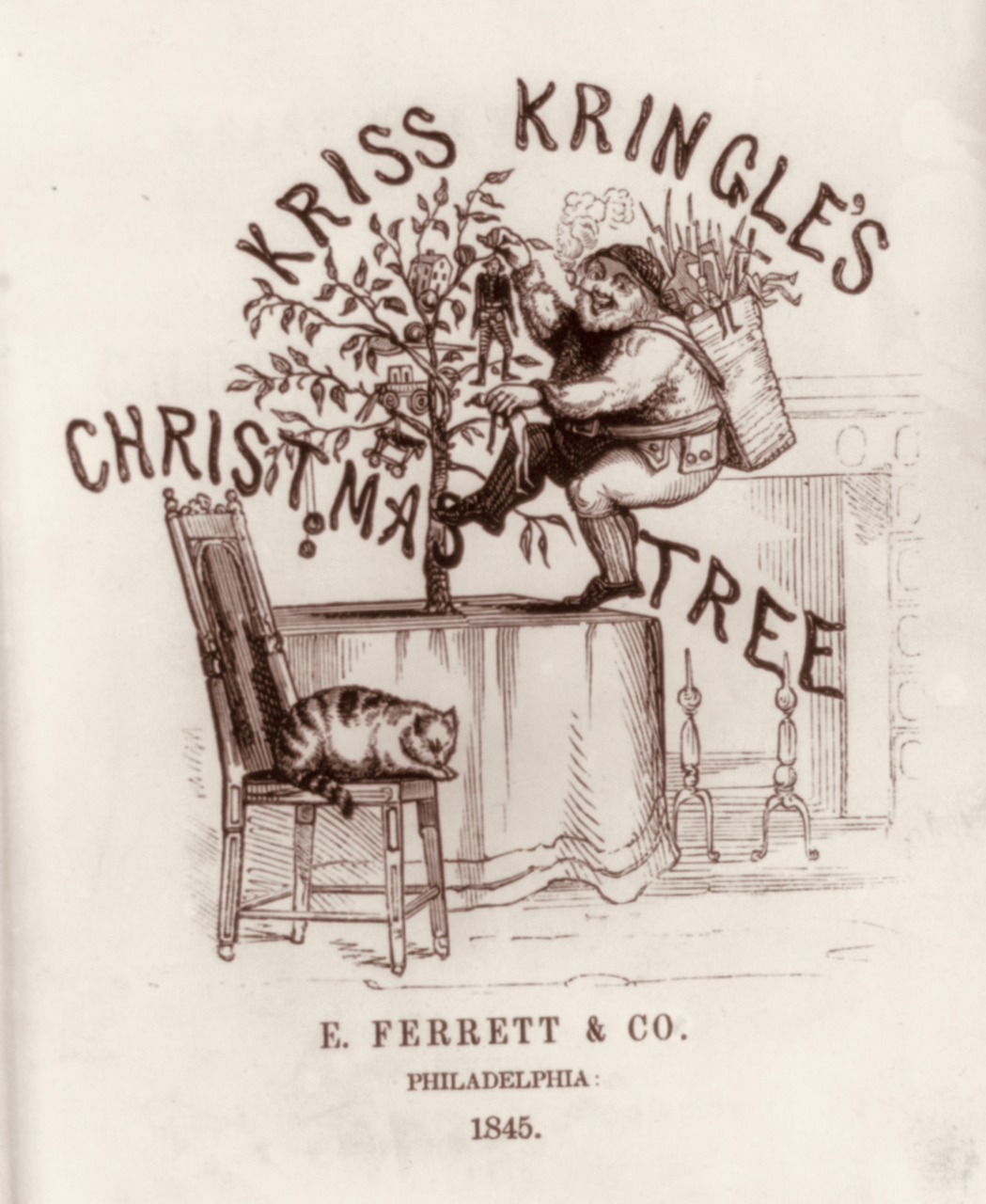
KrissKringle’s Christmas Tree [title page], E. Ferrett & Co., Philadelphia, 1845. Library of Congress
I grew up in the Chicago suburbs, and I remember the holiday thrill of riding the Chicago & Northwestern commuter train downtown with my parents, and then walking into the majestic State Street headquarters of Chicago’s grandest department store, Marshall Field & Company. Our mission? A trip up to the “toy floor” at Field’s, where we would wait in line to tell Santa all the wonderful things we would like to receive for Christmas that year.1
It goes without saying that I haven’t been able to fit on Santa’s lap for a very long time. But as the Clark House Historian, I still have holiday dreams and wishes, and today I’d like to share some of them with you. Who knows, perhaps Santa will work his magic once again?
(Official disclaimer: I do not serve on the JCH Board of Directors, or any of its committees. This is my Christmas daydream, a fantasy of what I’d like to see unfold at my favorite museum, given unlimited resources. And besides, as the great Chicago architect and city planner Daniel Burnham famously said: “Make no little plans. They have no magic to stir men’s blood!”)
My list is organized into several parts, the first of these is…
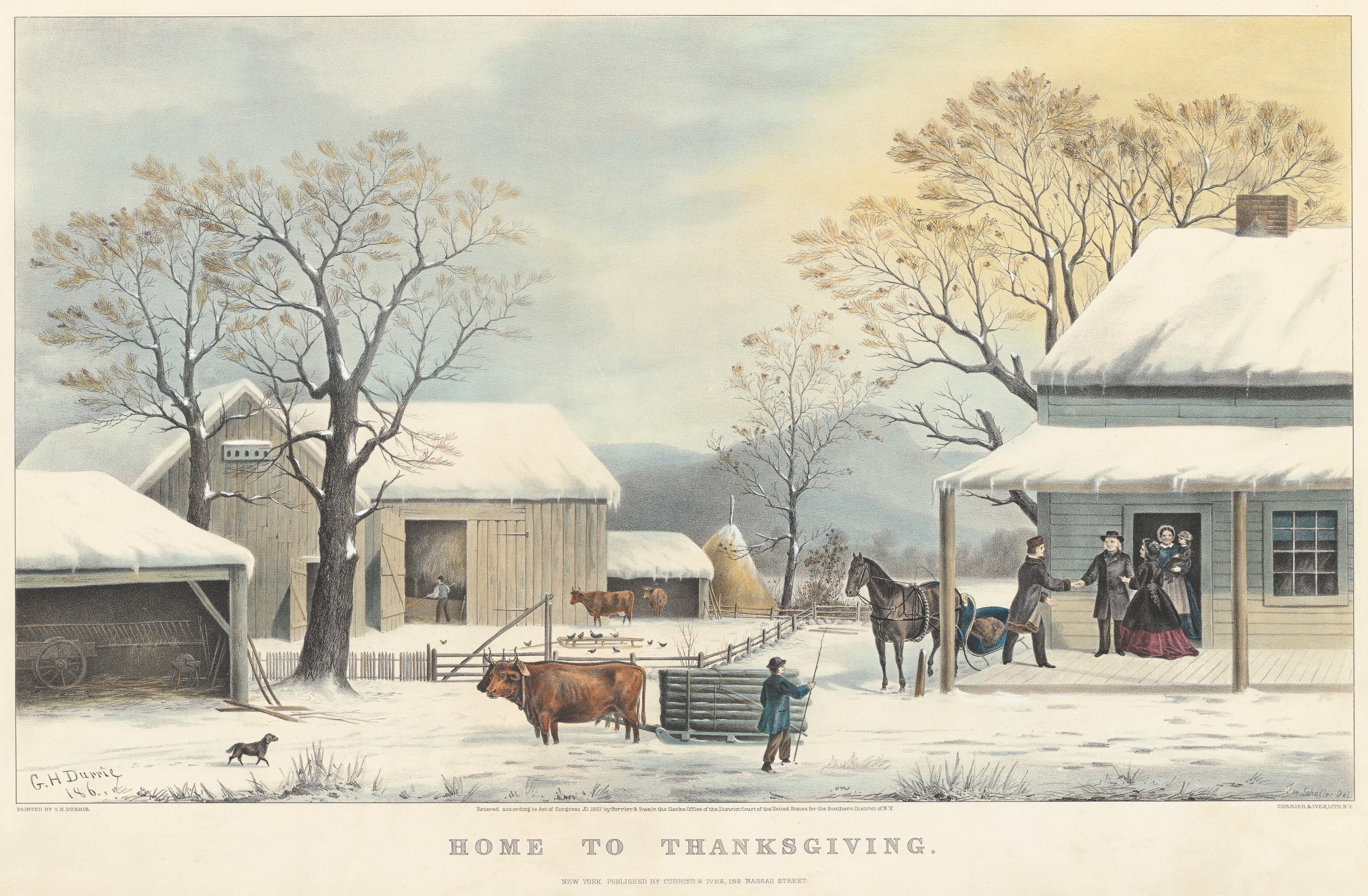
It’s Thanksgiving today, and I’m taking a few days off to spend time with family. But in the spirit of the holiday, I thought I’d reprint a lightly revised version of our now-annual Thanksgiving post, to share with you a few vintage recipes and a nice Currier & Ives lithograph from the period.1
Thanksgiving, 1867
Durrie, George H. and John Schutler, Home to Thanksgiving, ca. 1867, New York, Currier & Ives. National Gallery of Art, Collection of Mr. and Mrs. Paul Mellon. Public Domain. Click to to open larger image in a new window.
The Clark House Historian at his desk, wondering where October went…1
It’s been over a month since our last Clark House Historian post! Sorry about that. It’s not that I haven’t been busy with JCH writing and organizing. I have been. But most of my work for the last month has been done behind the scenes as the Jonathan Clark House graphic designer and webmaster.
For a good roundup of what’s been going on, please head over to our JCH official website and click on the News & Events page for details.
I’m getting back into the blogging groove, and one of my first projects is to continue our series “Not our Jonathan: other “J. M. Clarks” in 1830s & ’40s Wisconsin.” And in my research for that, I’m looking into the identities of one or more men named “J. M. Clark” that served as chaplain at the 5th Regiment’s post at Fort Winnebago.
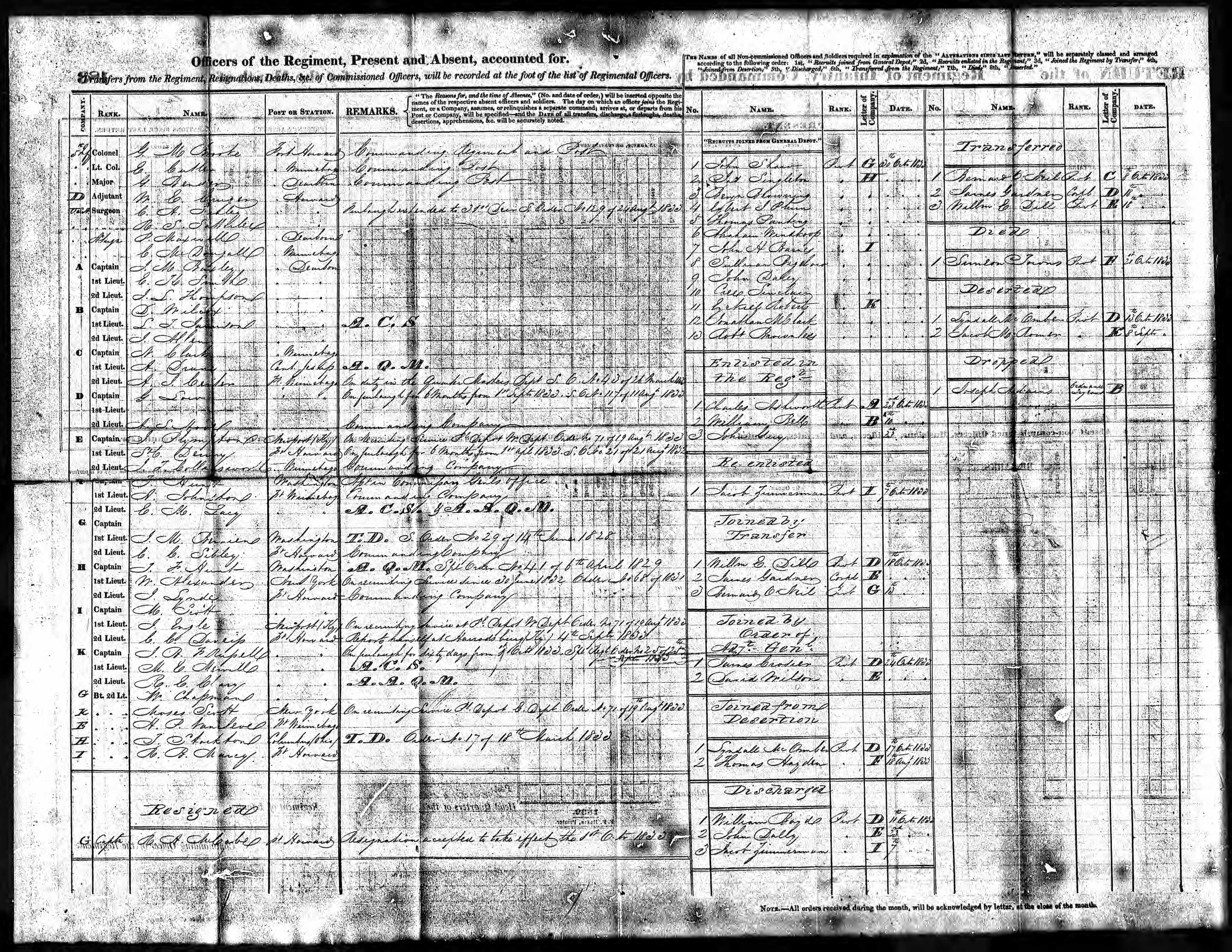
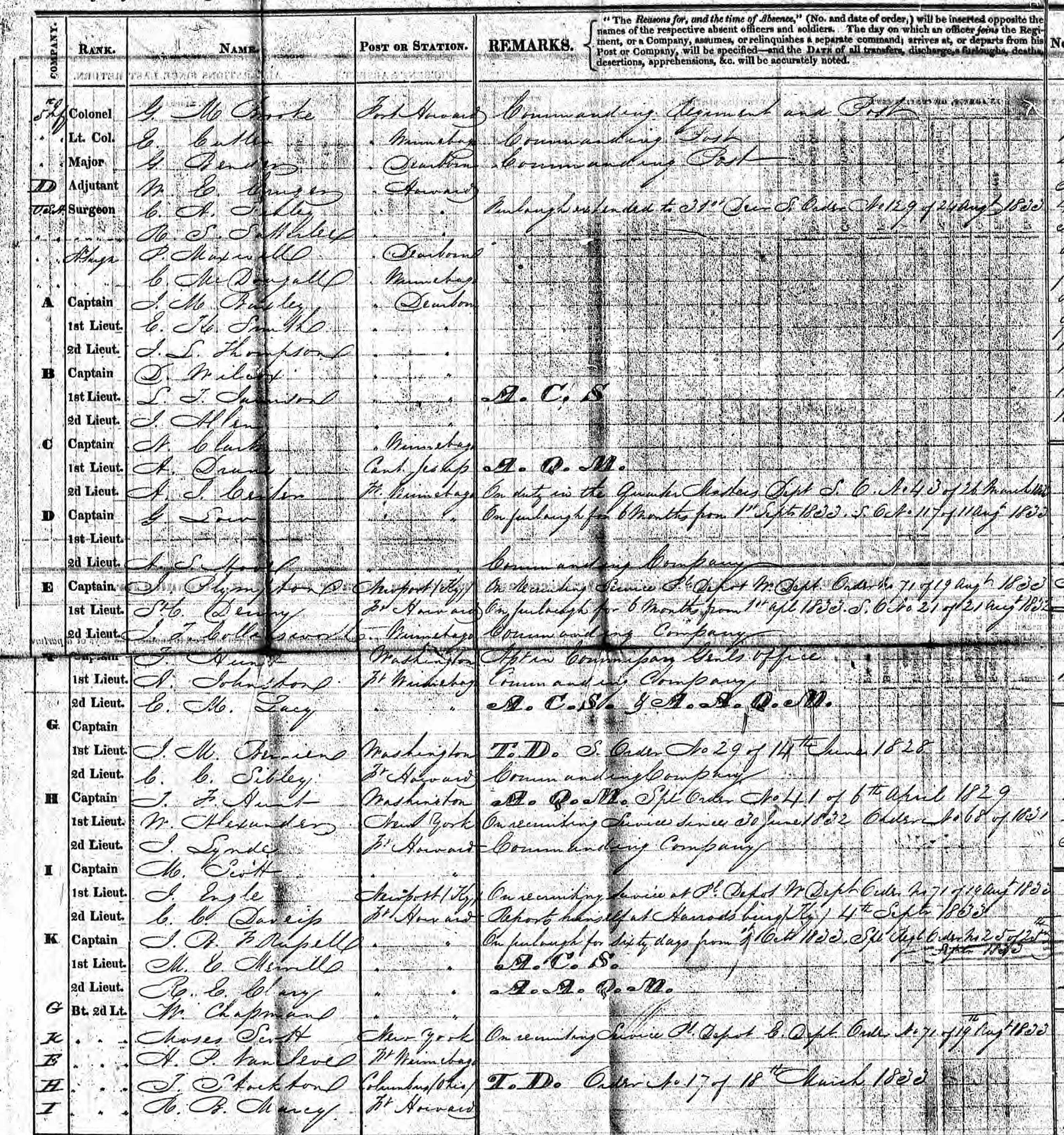
An important primary source for this research are the monthly “Returns” or reports, sent from the 5th Regiment’s posts at Forts Howard and Winnebago back to the army’s chief bureaucrat, the Adjutant General, in Washington, D.C. We’ve examined these Returns several times on Clark House Historian, including this post from 2016 which discussed this October, 1833, bit of U.S. Army record-keeping, the Return of the Regiment [for the 5th Regiment Infantry, at Fort Howard], October, 1833, verso:
NARA, Washington, D.C.; Returns from Regular Army Infantry Regiments, June 1821 – December 1916; Microfilm Serial: M665; Roll: 54 Military Year : 1832-1842. Return of the Regiment [for the 5th Regiment Infantry, at Fort Howard], October, 1833, verso, from Ancestry.com (pay site).
What’s that name???
For our purposes, one of the most useful features of these monthly Returns is the top left section of the form, which lists the officers of the regiment by [Company], Rank, Name, Post or Station, and with a space for Remarks about their assignments, temporary duty, leaves of absence, and so on. There’s a lot of useful information here, especially the names of the officers and the companies that they lead. But click the image to open a larger version of this image, and see if you can actually read those names:
On the one hand, the regimental clerk that filled out this October, 1833, form had pretty tidy penmanship, and the digitized microfilm image is not too bad. But even so, some of the names are hard to decipher. And knowing these names can be really useful, for example when looking for correspondence between these regimental officers and the Adjutant General’s office in D.C. (See our post here, for more on this archive.)
So how do we learn “Who’s Who” on the monthly “Returns from Post” and “Returns of the Regiment”? Fortunately, the government put all that info into a series of very useful books, which are now available, for free, online…
UPDATED October 5, 2024, at 9;30 pm to correct a number of typos and other infelicities.
Phew! What a busy September! I got to talk about some very interesting topics last month, to some very enthusiastic and attentive audiences. Lots of work, but very enjoyable. The first of these events was my September 13, 2024, after-dinner presentation at the Fall Workshop of the Wisconsin Society, Daughters of the American Revolution (WSDAR). My topic was “Building the Military Road, Wisconsin Territory’s First Federal Road.”
Photo credit: Laura Rexroth
I incorporated into the talk some important parts of the 1830s and ’40s army and road-building information that I’ve blogged about here at CHH, as well as new primary source materials and a whole bunch of relevant photographs and illustrations.
The WSDAR and the Military Road
An important, ongoing part of the WSDAR’s mission over the decades is historic preservation and education. The Wisconsin Society DAR’s main historic preservation effort involves the care and presentation of the last bit of Fort Winnebago still standing, the historic Fort Winnebago Surgeon’s Quarters.
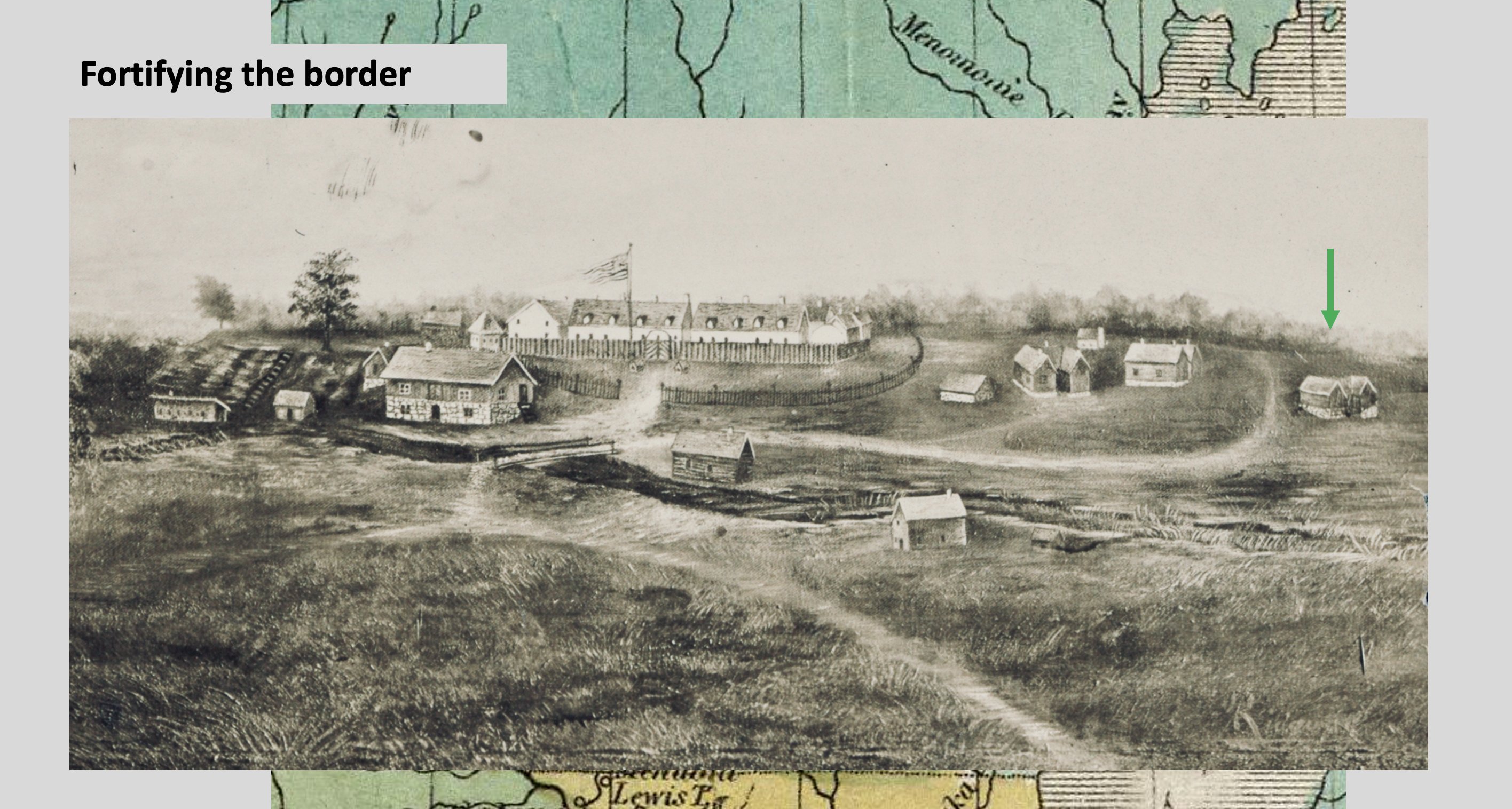
“Fortifying the Border,” slide from my “Old Military Road” presentation.
This image of Fort Winnebago, at the Portage between the Fox and Wisconsin Rivers, was created in the mid-nineteenth century and reproduced on a 1909 postcard. In the detail shown here, the building that is now the WSDAR’s historic Fort Winnebago Surgeon’s Quarters museum is indicated by green arrow. The uncropped full image—including a view of the Historic Indian Agency House—is available from the Library of Congress.
The WSDAR also has an interest in Wisconsin’s Old Military Road that dates back at least to 1930, when Columbia County’s Wau-Bun Chapter, WSDAR placed a series of handsome cast-steel markers along their portion of the route of the Old Military Road. As you might imagine, these have suffered from almost a century of Wisconsin weather and random damage or theft. State regent Sandra Snow has made the restoration and replacement of the 1930 markers one of her signature projects. Here’s a before and after of one of those markers: