I’m still sifting through a huge (mostly digital) pile of Caroline M. Clark and William W. Woodward sources and trying to organize them into a series of coherent and interesting posts for you. Sort of like assembling a bunch of hastily-drawn field surveys and turning them into accurate topographical maps or railroad construction plans:
Unknown photographer, W.W. Wright, Chf. Eng. & … Mil. RRds. United States, circa 1861 and 1866. Library of Congress. Click to open larger image in new window.
Caroline (Clark) Woodward, in our first Clark family endorsement!
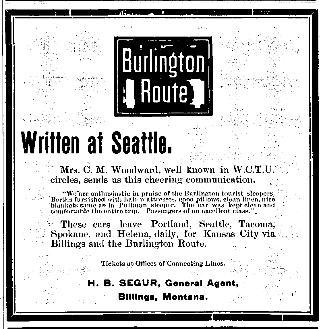
Here’s something new for Clark House Historian: a commercial endorsement from one of Jonathan and Mary Clark’s children! In June, 1900, our own Caroline M. (Clark) Woodward recommended travel on the Burlington Route in this newspaper ad…
Woodward, Caroline in railroad advertisement, Red Lodge Picket, Red Lodge, Montana, June 1, 1900, page 3. Click to open larger image in new window.
Mrs. C. M. Woodward, well known in W.C.T.U. circles sends us this cheering communication.
“We are enthusiastic in praise of the Burlington tourist sleepers. Berths furnished with hair mattresses, good pillows, clean linen, nice blankets, same as in Pullman sleeper. The car was kept clean and comfortable the entire trip. Passengers of an excellent class.”
Today, as we continue to explore the life of Jonathan M. and Mary (Turck) Clark’s eldest child, Caroline Mary Clark—later usually known as Mrs. C. M. Woodward—we’ll take a fact-by-fact look at the biographical sketch of Caroline that was published in 1893, re-printed unchanged in 1897, then abridged and reprinted in 1912. For a full discussion of these three publications, see last Monday’s Caroline M. (Clark) Woodward: first steps toward a biography.
Willard, Frances E., and Mary A. Livermore. 1893. A woman of the century ; fourteen hundred-seventy biographical sketches accompanied by portraits of leading American women in all walks of life ; ed. by Frances E. Willard and Mary A. Livermore, assisted by a corps of able contributors, title page and page 779.
Today’s post will be less of a fully-formed essay, and more of a running analysis, commentary, and proof-reading of this 1893 biographical sketch. We’ll take one portion at at time, starting at the beginning. The source text will be presented as a shaded quotation, followed by my commentary and corrections in simple black text on white background, with highlighted links to additional sources and explanations and, of course, a few footnotes, too. Here we go…
In our most recent blog post, Another family portrait! Caroline (Clark) Woodward, c. 1890s, we located and discussed the history of a previously unknown photo of Jonathan M. and Mary (Turck) Clark’s eldest child, Caroline Mary Clark, later usually known as Mrs. C. M. Woodward:
Townsend Elite Studio, [Portrait, Caroline M. (Clark) Woodward], inscribed “Mrs. C. M. Woodward, Supt. Work among Railroad Employes, N.W.C.T.U.”, photograph, circa 1889-1900. Photo courtesy Frances Willard House Museum & WCTU Archives, Evanston, Illinois. Click to open larger image in new window.
Caroline’s life was the most public—and perhaps best documented—of all the members of Jonathan M. Clark family, and is overdue for a closer examination. So today we begin a multi-part look at Caroline’s story, starting with three biographical sketches that were published during her lifetime.
UPDATED – October 9, 2021, with clarification that “NWCTU” means, indeed, the National (and not Nebraska) WCTU. UPDATED – October 8, 2021, to correct typos in the date range of the photo. Correct (maximum) date range is 1889 to 1900. Also removed a few randomly duplicated words in the first paragraph.
More Big News! It was only a few weeks ago that we presented a previously unknown photo of the youngest child of Jonathan M. and Mary (Turck) Clark, Dr. Jennie Clark Morrison. Today we have another great find, a professional photo portrait of the Clark’s eldest child, Caroline Mary (Clark) Woodward (1840-1924):
Townsend Elite Studio, [Portrait, Caroline M. (Clark) Woodward], inscribed “Mrs. C. M. Woodward, Supt. Work among Railroad Employes, N.W.C.T.U.”, photograph, circa 1889-1900. Photo courtesy Frances Willard House Museum & WCTU Archives, Evanston, Illinois. Click to open larger image in new window.
Clark family descendant Liz Hickman and I have been gathering information about Caroline for many years. Spurred on by this new photo of Caroline in her prime, I think it’s finally time to assemble the sources, line up the facts, and begin to share more of what we know about Caroline’s remarkable life as a teacher, wife, mother, and social activist. There is a lot of material to work with, so today let’s stay focused and just take a closer look at this new-to-us photograph.
UPDATED, Oct. 4, 2021, with a few minor edits and to add an additional footnote.
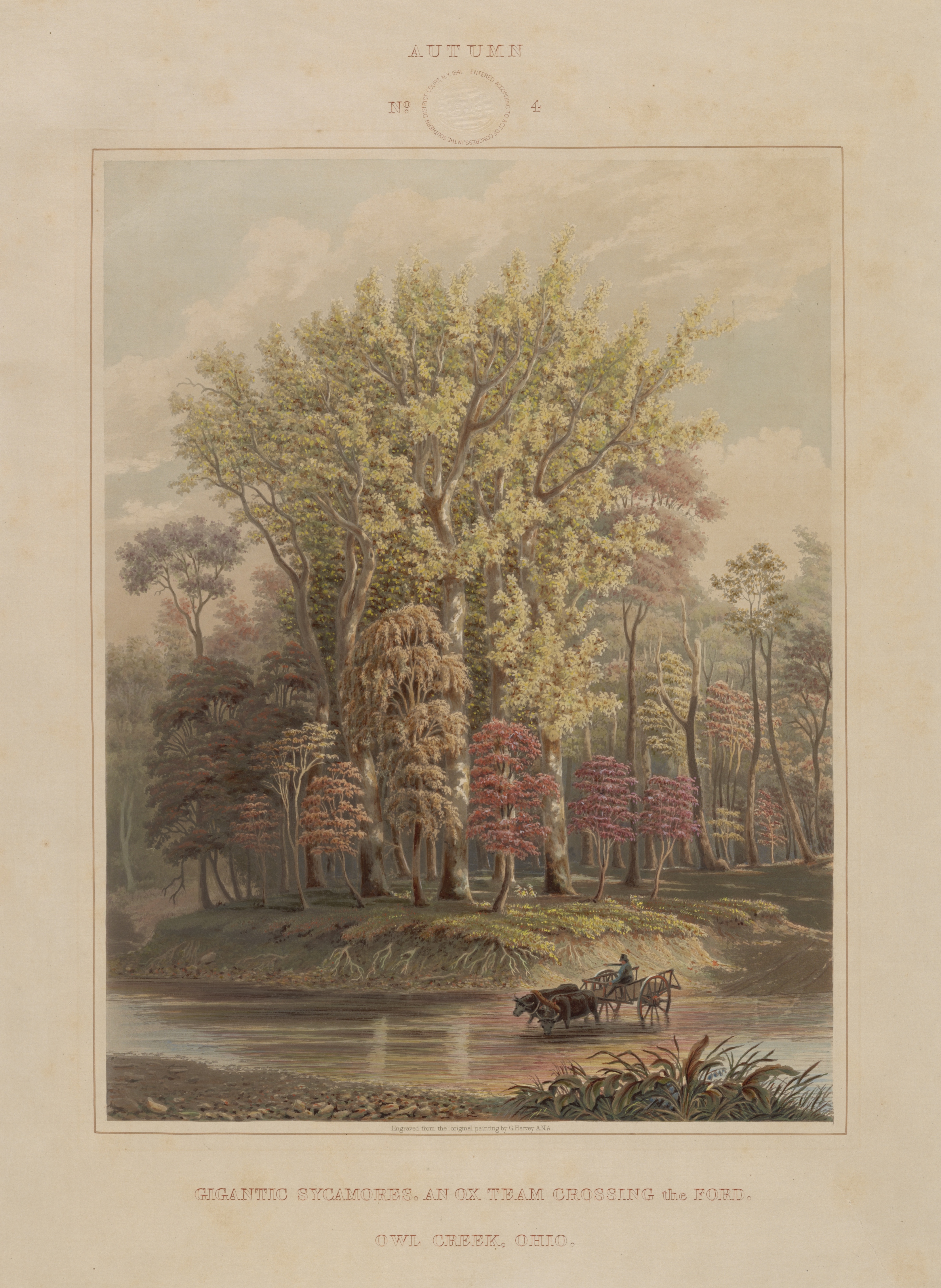
I’m still working on some longer posts; they should be ready soon. Meanwhile, I thought you might enjoy two lovely images, beginning with this nineteenth-century print, a view that would have been very familiar to a surprising number of our early Mequon immigrants:
These days—living and working inside our climate controlled, electrically illuminated spaces—it’s easy to miss nature’s seasonal changes. But you can be sure that our early Clark House residents, friends, and neighbors didn’t miss the start of autumn. Rural life was—and is—centered around the progression of the seasons, and autumn brought new farm and household chores to suit the changing weather and decreasing daylight.
So pile up your haystacks, sharpen and oil your tools before you store them in the barn, fill up the root cellar with food for the next six months or more, and keep chopping firewood for the winter woodpile. It’s time to mark the end of summer and the start of fall with a handsome seasonal image from the Clark’s era:
Autumn, No. 4: Gigantic sycamores. An ox team crossing the ford. Owl Creek, Ohio
More on JMC’s path from New York to Fort Howard, 1833
In our post How’d they get here? – JMC to Ft.Howard, 1833., I surmised that new army recruit Jonathan M. Clark mustered in at Ft. Niagara, New York, and then went from there to join his regiment at Fort Howard, Green Bay, Michigan (later Wisconsin) Territory. I’ve since discovered two newspaper items that support that surmise. Here’s one from Spring, 1833, about five months before JMC signed his enlistment papers in Utica, New York:
[Recruits travel from Ft Niagara to Buffalo], dateline Buffalo, May 22, reprinted in [Philadelphia] Daily Chronicle, May 29, 1833, page 3. genealogybank.com. Click image to open image in new window.
On May 22, 1833, ninety fresh U.S. Army recruits marched from the army’s personnel depot at Ft. Niagara to “Tonawanta,” presumably the New York village of Tonawanda, located where Tonawanda Creek, the final stretch of the westbound Erie Canal, meets the Niagara River:
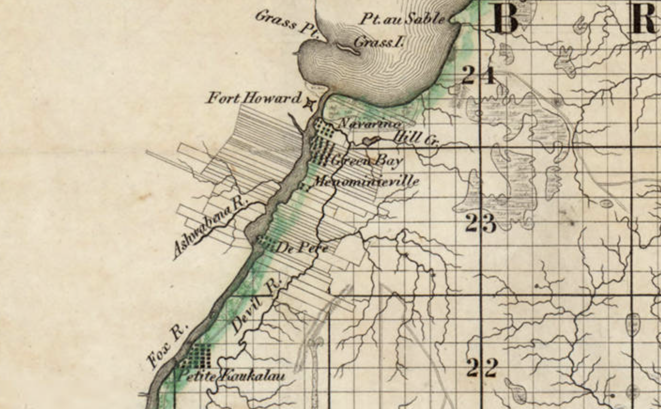
Last time, we illustrated our look at Ft. Howard with this detail from the first widely-available map of Wisconsin—and the first map of the territory based on official surveys—published in 1837:
Detail, Topographical map of Wisconsin Territory / compiled from the Public Surveys on file in the Surveyor General’s office … by Samuel Morrison, Elisha Dwelle [and] Joshua Hathaway, 1837. American Geographical Society Library Digital Map Collection, University of Wisconsin–Milwaukee. Click the detail map to open a larger version in a new window. Click here for a link to the complete map at UW-M with full bibliographic information.
This detail—showing Fort Howard, Navarino and, at the top, the southern end of Green Bay—was the subject of a Monday: Map Day! post in December, 2020, and gives a good picture of the topography and settled areas along the final miles of the Fox River as it empties into Green Bay. But on closer look, the details of the fort and its layout are very vague, limited to one X-shaped symbol. For a better understanding of Fort Howard in its most active era, we need to look at the actual 1823/1827 federal survey upon which the 1837 map was based:
Private Claims at Green Bay, 1823/1827
Detail, [Title section] of map, Private Claims at Green Bay, surveyed in July, Aug.t & Sept.r 1823; see image of complete map for full citation. Click to open larger image in new window.
Our series of “How’d they get here?” posts is written to illustrate the nuts and bolts of how our early Mequon pioneers travelled from their original homes or ports of arrival in North America to the newly opened federal lands in Wisconsin Territory, circa 1830-1850. Today’s post continues our previous post, a first-person description of 1830s frontier tourism that we called How’d they get here? Detroit to Ft. Howard, 1834 (part 1).
Picking up where we left off…
Wednesday, July 16, arrival at Green Bay
On Wednesday, as the Sun was slowly sinking to its repose in cloud of the most gorgeous and variegated colors, we arrived at the extremity of Green Bay, and about two miles up the Fox river, we landed at Navarino,2 receiving as we passed a salute from Fort Howard, on the opposite side of the river.
Detail, Topographical map of Wisconsin Territory / compiled from the Public Surveys on file in the Surveyor General’s office … by Samuel Morrison, Elisha Dwelle [and] Joshua Hathaway, 1837. American Geographical Society Library Digital Map Collection, University of Wisconsin–Milwaukee. Click the detail map to open a larger version in a new window. Click here for a link to the complete map at UW-M and its bibliographic information.
This map detail—showing Fort Howard, Navarino and, at the top, the southern end of Green Bay— is from the Topographical map of Wisconsin Territory, published in 1837 and the subject of a Monday: Map Day! post in December, 2020. As a reminder, this 1837 map shows all the lands officially surveyed by the federal government up to the time of publication. In 1837, the territory to the north and west of the Fox and Wisconsin rivers was still reserved for Wisconsin’s Native Americans, so the lands to the north and west of the Fox River are left (mostly) blank on this official map. But this land was not at all “empty.” The Indians, the forests, the wildlife, some of the old Métis and Anglo-American settlers—and the army—were all on the left bank of the Fox River in 1837, as they were in 1834, when the steamboat Michigan and its passengers arrived in Green Bay.