I know it’s been a while since my last post, but I’ve been busy! Jonathan Clark House executive director Nina Look and I just finished the latest JCH newsletter, and there’s a lot of Clark House history coming your way this fall, both here on the blog, and “live and in person.” In particular, I’m currently racing to finish not one, but two, illustrated presentations that I’ll be giving in September.
JMC, the Old Military Road, and the DAR
I’ve been asked to speak at the Fall Workshop of the Wisconsin Society, Daughters of the American Revolution. My topic will be “Building the Military Road, Wisconsin Territory’s First Federal Road.” I’ll be incorporating much of the 1830s and ’40s army and road-building information that I’ve blogged about here at CHH, as well as new primary source materials and contemporary illustrations.
The presentation will take place after dinner, Friday, September 13, at the WSDAR Fall Workshop in Oshkosh. The event is limited to registered DAR members and their guests. My thanks to Wisconsin State Regent Sandra Snow and the members of the WSDAR for their kind invitation to speak.
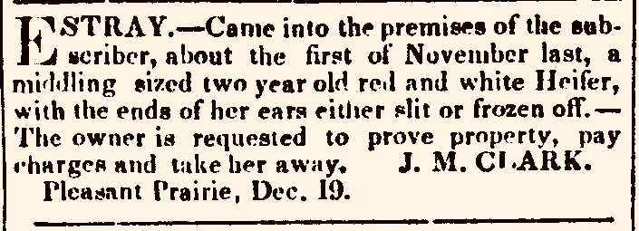
“Estray. […] J. M. Clark” advertisement, Southport [later Kenosha] Telegraph, Dec. 26, 1843, page 4
Hey! How did Mequon’s Jonathan M. Clark end up with a stray red and white heifer on his farm in…Pleasant Prairie, the most southeasterly township in all of Wisconsin, some 56 miles south of the Jonathan Clark House? The short answer is: he didn’t. The man that placed this “stray cow” advertisement in the December 16, 1843, issue of the Southport (later Kenosha) Telegraph was is not “our” J. M. Clark.
So many J. M. Clarks
Throughout the nineteenth century, many men seem to have been referred to, at least in print, by the initial letters of their first and middle names. The builder of Mequon’s Jonathan Clark House was no exception. Many of the documents made during his lifetime refer to him as “J. M. Clark,” and he often signed his name that way as well.1
“J. M. Clark,” signature of Jonathan M. Clark, from his final U.S. naturalization papers, 1853.
Unless the researcher is careful, it’s easy to make assumptions and presume that the “J. M. Clark” that built our historic Mequon home in 1848 is identical with the other “J. M. Clark” men that appear in various Wisconsin Territory documents, land patents, newspapers, and histories. Unfortunately, this is not always the case. To be certain that the “J. M. Clark” referred to in a particular source is “our” Jonathan M. Clark, we need to understand the “who, what, where and when” of each document or event that may—or may not— have involved our Jonathan.
I’m sure my list of suspects is incomplete, but (surprise!) it has turned out to be much longer and more complicated than anticipated. With that in mind, I think I’m going to need several CHH posts to sort out some of the most easily mistaken “J. M. Clark” men that lived and worked in the central and southeastern parts of Wisconsin Territory, yet were definitely not our J. M. Clark, the man born in Lower Canada (or Vermont) in 1812 that went on to build the historic Jonathan Clark House in Mequon in the 1840s.2
Let’s start with earliest and most northerly of these settlers, the first of several Christian ministers surnamed Clark that had links to Wisconsin Territory army posts that were home to our Jonathan M. Clark and his comrades during their service with the U. S. Army’s 5th regiment of infantry, 1833-1836.
I’m still on the search for Jonathan M. Clark’s parents and other kin somewhere in the early-19th-century wilderness of northern Vermont and southern Québec. I hope to publish more about that here in the near future.
As part of that project, I’ve spent quite a bit of time over the past few months organizing and re-examining the many research materials that I’ve gathered about JMC and his world, and I’ve constructed a whole bunch of genealogies for early Vermont, New Hampshire, and Lower Canada families named Clark that turn out—alas!—not to be related to our Jonathan M. Clark.
More mysteries…
Along with the mystery of JMC’s still-unknown family and childhood, Clark House museum director Nina Look and I have been trying to chase down some rumors that suggest Jonathan Clark may have spent his three years between mustering out of the U.S. Army (in 1836), and purchasing land at the land office in Milwaukee (in late 1839), as a surveyor in or near the area around Fort Winnebago, Columbia County, Wisconsin Territory. At the moment, that story remains a mystery, too. I’ll let you know if we find out more.
Anyway, with all these facts, rumors and mysteries—and many, many others—rolling around in my head, I thought it might be useful to outline JMC’s life in a handy, chronological timeline. Here’s a draft of that timeline, including what we do—and don’t—know about Jonathan M. Clark’s whereabouts and activities during his lifetime, as of July 1, 2024. I’ve included links to some relevant Clark House Historian posts where possible; please click on them for more information.
Here’s another addition to our list of various Clark-surnamed people that show up in our search for Jonathan M. Clark’s kin, but we now know (with reasonable certainty) were not JMC’s parents or other relatives.
Today’s “Clark” subjects are connected to the history of the U.S. Army’s Fort Winnebago, and the surrounding area of Columbia County, Wisconsin Territory, during the decade of the 1830s.
Fort Winnebago was one of several posts in the upper Midwest garrisoned by the army’s Fifth Regiment of Infantry during Jonathan M. Clark’s three-year term in the army at Fort Howard (1833-1836). From about 1835-1836, the soldiers of the 5th regiment were responsible for cutting Wisconsin’s original east-west Military Road from Ft. Howard at Green Bay, to Ft. Winnebago at the portage between the Fox and Wisconsin Rivers, and thence to Ft. Crawford at Prairie du Chien. In the 1830s, in addition to recent recruit Jonathan M. Clark, at least two other men with the Clark surname held positions with the 5th regiment in Wisconsin. Neither of these notable Clark men—it turns out—is related to JMC.
I’m not going into great detail for each subject, but I’ll try and give enough info to make clear whom we are talking about, and why they are being added to the “Nope, not our Clark family…” list. Leading today’s installment is one of the 5th regiment’s senior officers and members of his pioneering family:
Our annual Memorial Day post, first published in 2020. Updated for 2024 with new information about the Civil War service of Isham and Emily (Bigelow) Day’s eldest child, Cpl. James Lemon Day (1834-1863).
Graves of Unknown Union Soldiers, Memphis National Cemetery, photo by Clayton B. Fraser, (Library of Congress), public domain. Memphis National Cemetery is the final resting place of Mequon’s Watson Peter Woodworth, and almost 14,000 of his Union Army comrades.
Today is the day our nation officially observes Memorial Day. For many Americans, Memorial Day represents “the first day of summer,” and is traditionally celebrated with trips to the lake, picnics, parades, and sales on cars, appliances, and other consumer goods.
But for many of us, Memorial Day remains rooted in its origins as Decoration Day. The first national observance was in 1868, when retired general John A. Logan, commander and chief of the Grand Army of the Republic—the Union veterans’ organization—issued his General Order Number 11, designating May 30 as a memorial day “for the purpose of strewing with flowers or otherwise decorating the graves of comrades who died in defense of their country during the late rebellion, and whose bodies now lie in almost every city, village, and hamlet churchyard in the land.”
On this Memorial Day, let’s take a moment to remember what this day truly represents.
Sorry for the “radio silence” lately. I’ve been occupied with a number of tasks on- and off-line and then, early last morning, we had a big thunderstorm, and it seems that one or more of the storm’s lightning strikes managed to fry our family’s wi-fi modem-router. Imagine that. No internet! How does a blogger cope?
The cold realization of an off-line Monday was followed by the prospect of what lay ahead: going to my day job (meh), and then, after work, needing to choose and purchase a new modem-router (not too bad, perhaps) and then having to spend hours trying to follow the inevitable—and laughably & misleadingly-labeled—”few easy steps” to set up the new Wi-Fi hub and connect it to our existing internet service and other devices (I’ve done this before and, frankly, I’d rather visit the dentist).
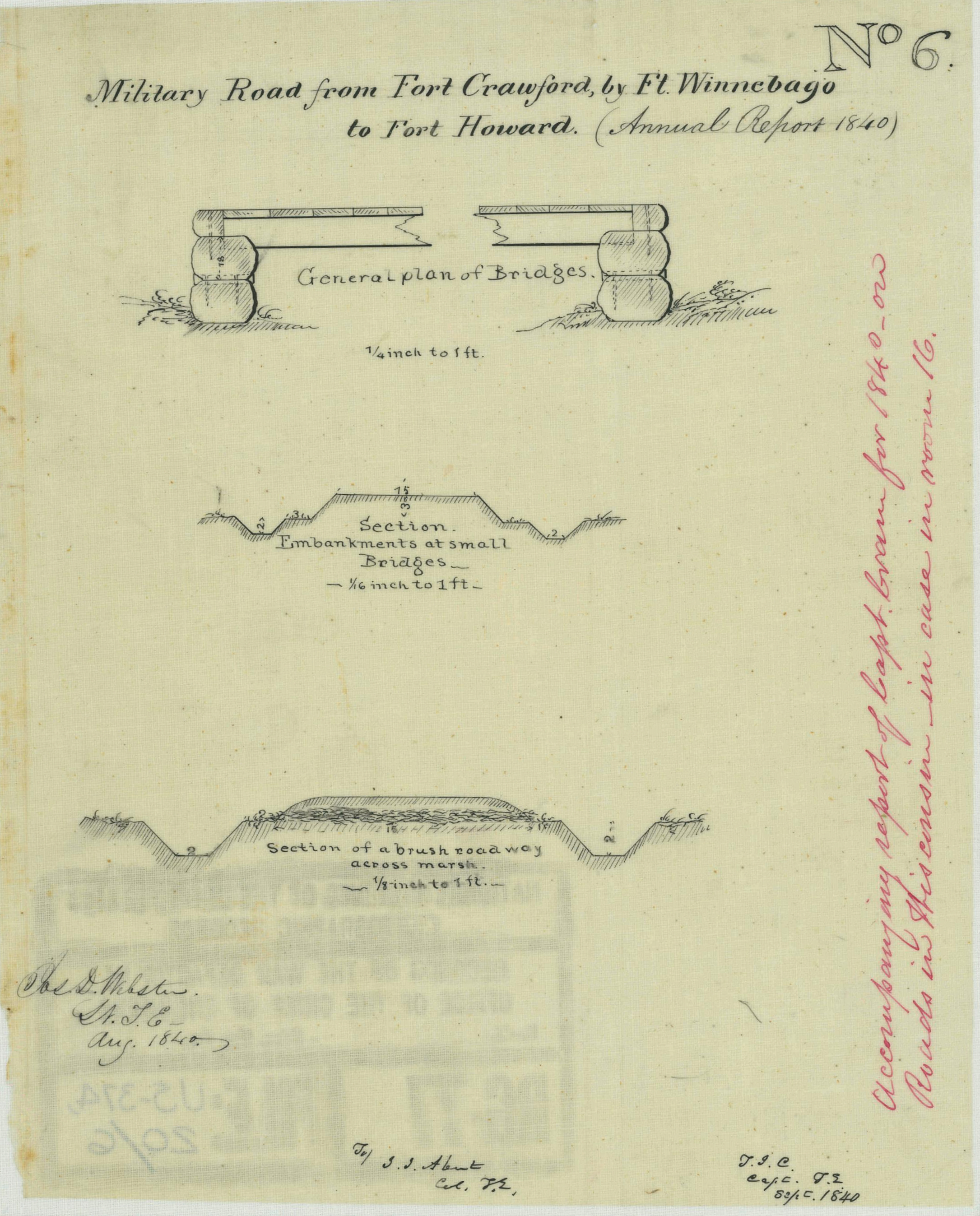
Time for one more follow-up to our recent posts Monday: Map Day! – Wisconsin’s Federal Roads in 1840 and JMC, the Army, and the Military Road, 1835-1840. As I mentioned in that “Monday: Map Day!” post, I recently found some unique maps and related documents in the digitized collections of the National Archives and Records Administration (NARA), in particular a group of maps and drawings created in 1840 by members of the army’s Corps of Topographical Engineers under the supervision of Capt. T. J. Cram.
Before they get lost in my files, I thought I’d share the other documents from Capt. Cram’s 1840 survey that have survived and been digitized by NARA. I’ve already said quite a bit about these 1840 maps and drawings; now I’m most interested in gathering the remaining 1840 documents and their bibliographic citations here for reference. So not much commentary today, but lots of images. And—as always—I recommend clicking on each item to open a larger, higher-resolution image in a new window.
Bridges on the Green Bay Road
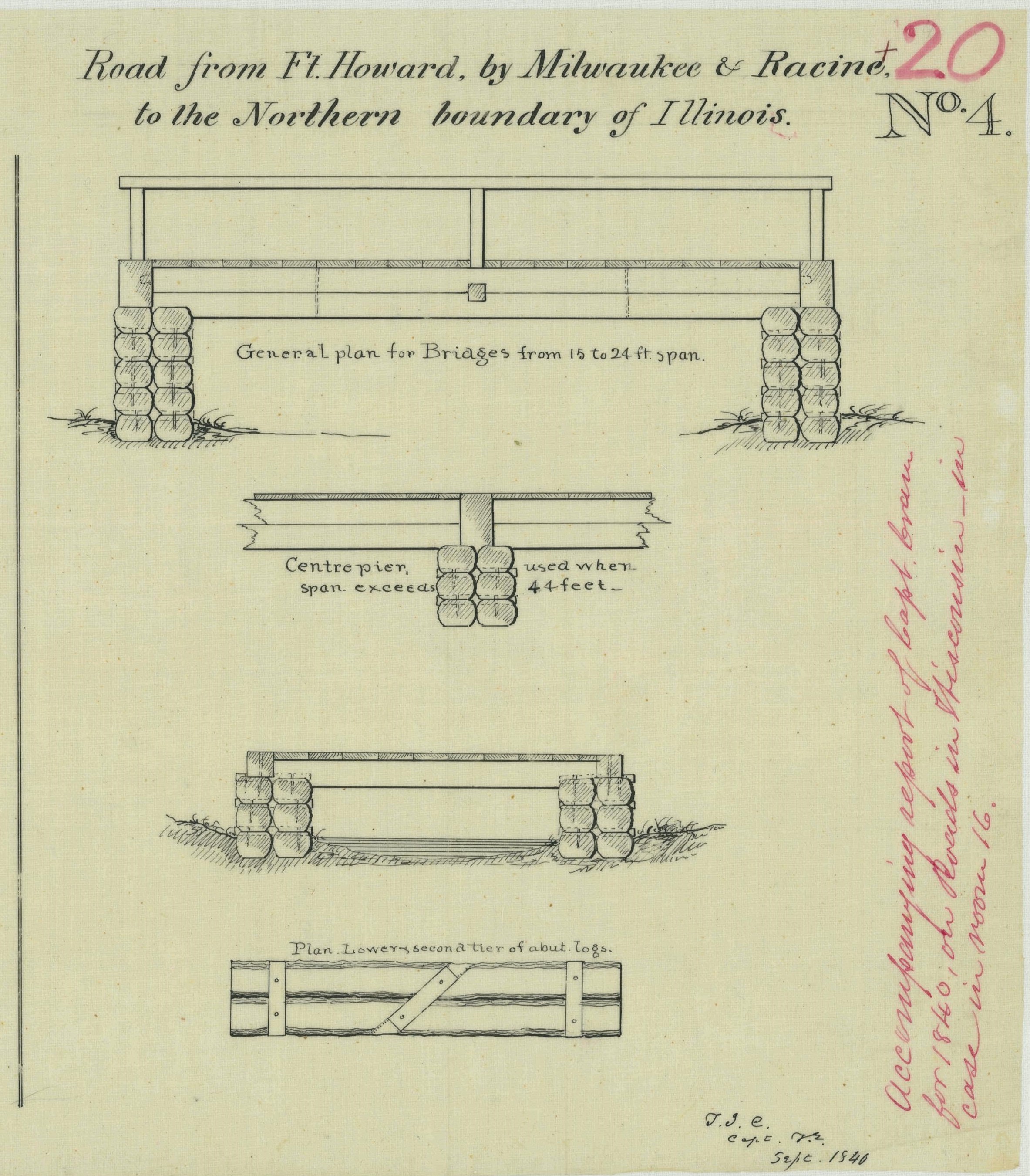
The first item is of particular interest for Clark House history fans, as it provides additional details about old Washington/Ozaukee county’s first federal road, the north-south route connecting Fort Dearborn, Chicago, to Fort Howard at Green Bay. The drawing is part of a larger document; this portion is titled “Road from Ft. Howard, by Milwaukee & Racine, to the Northern boundary of Illinois.”
The drawing illustrates construction details of the simple wooden bridges that were part of the Green Bay Road, circa 1840. This road, and these bridges, comprised the main north-south transportation route for the U.S. Mail and for immigrants and settlers of the new counties of southeast Wisconsin Territory. The Clarks, Turcks, Bonniwells and other early Mequon pioneers would have crossed bridges like these on their trips to and from Milwaukee, Grafton, Port Washington and beyond on the Green Bay Road.
Today’s post is a follow-up to our recent Monday: Map Day! – Wisconsin’s Federal Roads in 1840. It features another document created by the U.S. Army’s Corps of Topographical Engineers and preserved in the collections of the National Archives and Records Administration. Today’s drawing interests us as it documents—in some detail—the kind of road building work that Pvt. (later Sgt.) Jonathan M. Clark performed as a member of Company K, 5th Regiment, U.S. Infantry.
Webster, Jos. D, et. al., “Military Road from Fort Crawford to Fort Winnebago to Fort Howard (Wisconsin),” NARA, Record Group 77: Records of the Office of the Chief of Engineers, Series: Civil Works Map File, File Unit: United States, accessed here, April 14, 2024.
This document interests us because after JMC left the army he, with many of his early Mequon neighbors, spent a good part of the 1840s surveying, cutting, clearing, and grubbing out some of old Washington/Ozaukee county’s earliest roads. In the process, these pioneers had to bridge streams and rivers of various sizes and depths, and find ways to keep the unpaved roadway dry and firm. How did they do it with the limited supplies and tools at hand?
Today’s document shows how the U.S. Army solved some of those issues a bit farther north, on Wisconsin’s east-west Military Road. The techniques and approaches to road construction use there may have influenced how JMC and our early county road builders solved the problems of building roads in the forests, wetlands, and open prairies of 1840s Washington county.
I spent much of January and February preparing my March 9th, 2024, Civil War presentation at the Cedarburg History Museum. In that talk I tried to take a more personal and local look at the war by examining the military service of few of the Cedarburg relatives and future in-laws of 1868-1873 Clark House resident Fred Beckmann. In my research, I found some unique stories of their years of Union service in the 9th and 26th Wisconsin Infantry Regiments, as well as the impact of the war on families and friends back home in Wisconsin.
I also found several new online collections of unique maps and historical documents. Today’s map is from one of those online sources, the digitized map collection of the National Archives and Records Administration (more on NARA and its holdings, below). This map was made 20 years before the Civil War, in September, 1840, and is one of the earliest—if not the earliest—maps of the federal roads in Wisconsin Territory.1
Today’s Monday: Map Day! revisits and makes a correction to an interesting map that we first discussed here on October 29, 2017, and then re-visited on July 11, 2020. And for unknown reasons, that original 2017 post—according to my monthly WordPress statistics report—was the most-viewed post on this site for the month of January, 2024, with 341 views (!).
Burr, David H. Map of the Northern Parts of Ohio, Indiana and Illinois and Michigan and that part of the Ouisconsin Territory lying East of the Mississippi River, 1836, detail of title & author. Library of Congress.
The 2020 re-post was originally conceived as a kind of addendum to our June-July, 2020, multi-part discussion of the earliest Wisconsin territorial, state, and federal censuses. It also served to locate Jonathan M. Clark in Wisconsin Territory during his U.S. Army service from September, 1833, to September 19, 1836.
Today’s post includes one particular correction that I’ve been meaning to make for a while. When I added my original annotations to a detail of this map (in red), in 2017, I made an error. I mislabeled Sgt. Jonathan M. Clark’s location at the time he mustered out of service, a temporary army camp along the under-construction military road from Fort Howard (Green Bay) to Fort Winnebag0 (Portage). JMC’s muster-out location was always referred to in the records of the Fifth Regiment of Infantry as “Camp Hamilton.” For some reason, when I made my annotated detail map, I incorrectly labeled this place “Ft. Hamilton.” A minor error, but worth correcting , especially now that this map is receiving fresh attention.1
It’s 1836. Where’s…Wisconsin?
In September, 1836, Sgt. Jonathan M. Clark was discharged from the U.S. Army at “Camp Hamilton,” Wisconsin Territory, after serving his three-year term of service with Co. K, Fifth Regiment of Infantry.2 One year later, in the autumn of 1837, Jonathan’s future wife Mary Turck would make the long trip from Palmyra, New York, to Milwaukee and finally Mequon, Washington County, Wisconsin, with her parents Peter and Rachael Turck and six younger siblings. By the end of 1840 Jonathan and Mary would be married and starting their family in Mequon.
That seems simple enough, until you take a moment to wonder how much Jonathan—or especially Mary and her family—knew about this new Wisconsin Territory. Jonathan had been in the territory since October, 1833, mostly on post at Ft. Howard. In the last year or so of his service he was busy cutting trees and building bridges for the military road along the Fox River waterway from Ft. Howard (Green Bay) towards Ft. Winnebago (near modern Portage). As a road-building soldier, Jonathan might have done some surveying and seen—or helped draw—a variety of maps of the military road and its vicinity. But for a better overview of this new territory, Jonathan or Mary might have sought out a map such as this: