Our annual Memorial Day post, first published in 2020. Updated for 2024 with new information about the Civil War service of Isham and Emily (Bigelow) Day’s eldest child, Cpl. James Lemon Day (1834-1863).
Graves of Unknown Union Soldiers, Memphis National Cemetery, photo by Clayton B. Fraser, (Library of Congress), public domain. Memphis National Cemetery is the final resting place of Mequon’s Watson Peter Woodworth, and almost 14,000 of his Union Army comrades.
Today is the day our nation officially observes Memorial Day. For many Americans, Memorial Day represents “the first day of summer,” and is traditionally celebrated with trips to the lake, picnics, parades, and sales on cars, appliances, and other consumer goods.
But for many of us, Memorial Day remains rooted in its origins as Decoration Day. The first national observance was in 1868, when retired general John A. Logan, commander and chief of the Grand Army of the Republic—the Union veterans’ organization—issued his General Order Number 11, designating May 30 as a memorial day “for the purpose of strewing with flowers or otherwise decorating the graves of comrades who died in defense of their country during the late rebellion, and whose bodies now lie in almost every city, village, and hamlet churchyard in the land.”
On this Memorial Day, let’s take a moment to remember what this day truly represents.
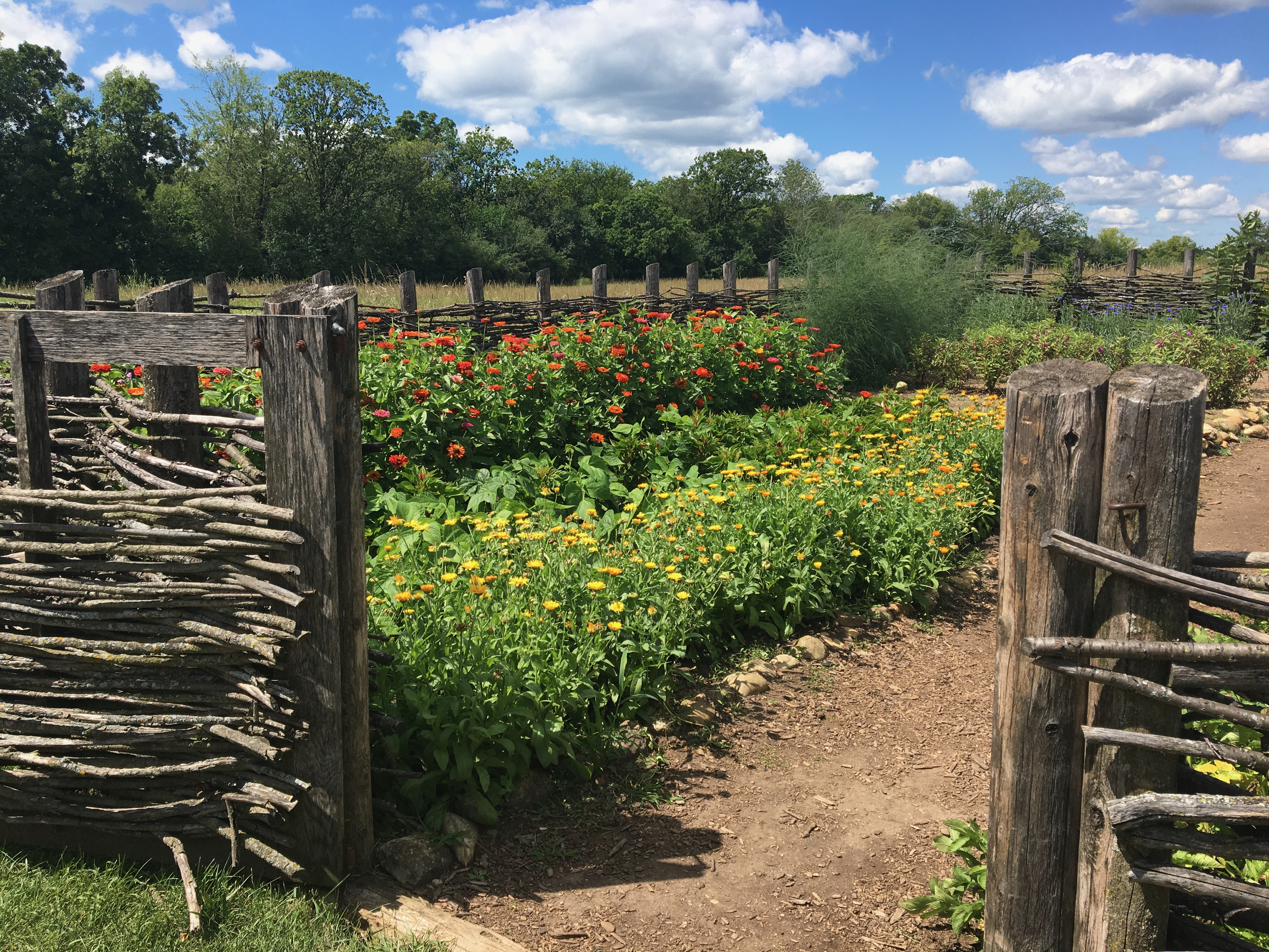
It’s already the second week of May, 2024, and summertime will soon be here. At our southeastern Wisconsin home the first spring flowers are done, and the next round of blossoms have been blooming for a week or two. The peas will soon be in the ground, and we already harvested enough rhubarb to make two and a half small jars of jam. The tomato and pepper seedlings and the squashes will go in soon, and I need to put up a trellis or two so we can start the big patch of green beans. So even though it’s “early” by the standards of previous years, we’ve got gardening on the mind here at the Historian’s house, and I thought you might enjoy a slightly-belated repost of this annual favorite, which first appeared here in April, 2021. Cheers!
Planning the garden
It’s early April, and the growing season is not far off. For a farmer like Jonathan M. Clark, it’s a little early yet for plowing and sowing, but not too early to make plans and sharpen the tools. For a farmer’s wife, like Mary (Turck) Clark, it’s not too soon to think about the farm garden, its crops and layout.
Garden at the Turck-Schottler House, 1870s Hessian Immigrant Farm, Old World Wisconsin. Photo credit Reed Perkins, 2022.1
I don’t know if Mary and Jonathan were regular readers of the popular and affordable farmers’ almanacs of their era; I wouldn’t be surprised if they were. There were many to chose from. Perhaps they had a copy of something like:
Today’s Monday: Map Day! revisits and makes a correction to an interesting map that we first discussed here on October 29, 2017, and then re-visited on July 11, 2020. And for unknown reasons, that original 2017 post—according to my monthly WordPress statistics report—was the most-viewed post on this site for the month of January, 2024, with 341 views (!).
Burr, David H. Map of the Northern Parts of Ohio, Indiana and Illinois and Michigan and that part of the Ouisconsin Territory lying East of the Mississippi River, 1836, detail of title & author. Library of Congress.
The 2020 re-post was originally conceived as a kind of addendum to our June-July, 2020, multi-part discussion of the earliest Wisconsin territorial, state, and federal censuses. It also served to locate Jonathan M. Clark in Wisconsin Territory during his U.S. Army service from September, 1833, to September 19, 1836.
Today’s post includes one particular correction that I’ve been meaning to make for a while. When I added my original annotations to a detail of this map (in red), in 2017, I made an error. I mislabeled Sgt. Jonathan M. Clark’s location at the time he mustered out of service, a temporary army camp along the under-construction military road from Fort Howard (Green Bay) to Fort Winnebag0 (Portage). JMC’s muster-out location was always referred to in the records of the Fifth Regiment of Infantry as “Camp Hamilton.” For some reason, when I made my annotated detail map, I incorrectly labeled this place “Ft. Hamilton.” A minor error, but worth correcting , especially now that this map is receiving fresh attention.1
It’s 1836. Where’s…Wisconsin?
In September, 1836, Sgt. Jonathan M. Clark was discharged from the U.S. Army at “Camp Hamilton,” Wisconsin Territory, after serving his three-year term of service with Co. K, Fifth Regiment of Infantry.2 One year later, in the autumn of 1837, Jonathan’s future wife Mary Turck would make the long trip from Palmyra, New York, to Milwaukee and finally Mequon, Washington County, Wisconsin, with her parents Peter and Rachael Turck and six younger siblings. By the end of 1840 Jonathan and Mary would be married and starting their family in Mequon.
That seems simple enough, until you take a moment to wonder how much Jonathan—or especially Mary and her family—knew about this new Wisconsin Territory. Jonathan had been in the territory since October, 1833, mostly on post at Ft. Howard. In the last year or so of his service he was busy cutting trees and building bridges for the military road along the Fox River waterway from Ft. Howard (Green Bay) towards Ft. Winnebago (near modern Portage). As a road-building soldier, Jonathan might have done some surveying and seen—or helped draw—a variety of maps of the military road and its vicinity. But for a better overview of this new territory, Jonathan or Mary might have sought out a map such as this:
Christmas is here, and I thought you might enjoy a repeat of this seasonal Turck family anecdote, “a true story,” as related in the pages of Correct English magazine, written, edited and published by Peter Turck’s granddaughter—and Mary (Turck) Clark’s niece—Josephine Turck Baker, and later collected with other similar tales and published as a book, Correct English in the Home, Chicago, 1909.
In the foreword to her book, the author explains:
When I was a little girl, like most children, I was very fond of listening to stories; but unlike most children, I did not care for fairy tales, my first question invariably being, ” IS IT A TRUE STORY?” I don’t want a “once upon a time” story. This is a true story. The children, their names, the incidents narrated, are all true. Beatrice, Roschen, and the “Boitie,” are my children […] For those who like really true stories of really true people with really true names, this little book is written. That it may instruct and entertain all readers, both little and big, young and grown up, is the earnest wish of Yours for Correct English, Josephine Turck Baker
How y’all doing? I can’t believe it’s been almost a month since my last post. Sorry about that! It’s that time of year, and I’ve been busier at my day job. But I’ve also been occupied with more pleasant, seasonal, activities…
Veterans Day is today. For a perspective on the day—and our early Mequon veterans—here’s a post originally published at Clark House Historian on November 11, 2016, and revised, expanded and republished several times since. For Veterans Day, 2023 I have added several new links and one new photograph.
Armistice Day
One hundred and five years ago, on the eleventh day, of the eleventh month, at the eleventh hour—Paris time—the Armistice of Compiègne took effect, officially ending the fighting on the Western Front and marking the end of World War I, the optimistically named “War to End All Wars.”
In the United States, the commemoration of the war dead and the Allied victory began in 1919 as Armistice Day, by proclamation of President Woodrow Wilson. Congress created Armistice Day as a legal holiday in 1938. Starting in 1945, a World War II veteran named Raymond Weeks proposed that the commemorations of November 11 be expanded to celebrate all veterans, living and dead. In 1954 Congress and President Eisenhower made that idea official, and this is what we commemorate today. There are many veterans with a connection to the Jonathan Clark house. We honor a few of them in this post.
Jonathan Clark, Henry Clark, and the U.S. Army
Jonathan M. Clark (1812-1857) enlisted as a Private in Company K, Fifth Regiment of the U. S. Army, and served at Ft. Howard, Michigan (later Wisconsin) Territory, from 1833 until mustering out, as Sargent Jonathan M. Clark, in 1836. In the 1830s, Fort Howard was on the nation’s northwestern frontier. Jonathan’s Co. K spent much of the summers of 1835 and 1836 cutting the military road across Wisconsin, from Ft. Howard toward Ft. Winnebago, near modern Portage, Wisconsin.
Fort Howard, Wisconsin Territory, circa 1855, from Marryat, Frederick, and State Historical Society Of Wisconsin. “An English officer’s description of Wisconsin in 1837.” Madison: Democrat Printing Company, State Printers, 1898. Library of Congress. Click to open larger image in new window.
Our annual Memorial Day post, first published in 2020. Updated for 2023 with new information about Evander B. Bonniwell’s service.
Graves of Unknown Union Soldiers, Memphis National Cemetery, photo by Clayton B. Fraser, (Library of Congress), public domain. Memphis National Cemetery is the final resting place of Mequon’s Watson Peter Woodworth, and almost 14,000 of his Union Army comrades.
Today is the day our nation officially observes Memorial Day. For many Americans, Memorial Day represents “the first day of summer,” and is traditionally celebrated with trips to the lake, picnics, parades, and sales on cars, appliances, and other consumer goods.
But for many of us, Memorial Day remains rooted in its origins as Decoration Day. The first national observance was in 1868, when retired general John A. Logan, commander and chief of the Grand Army of the Republic—the Union veterans’ organization—issued his General Order Number 11, designating May 30 as a memorial day “for the purpose of strewing with flowers or otherwise decorating the graves of comrades who died in defense of their country during the late rebellion, and whose bodies now lie in almost every city, village, and hamlet churchyard in the land.”
On this Memorial Day, let’s take a moment to remember what this day truly represents.
It’s already the third week of May, 2023, and summertime will soon be here. At our southeastern Wisconsin home the first spring flowersare done, and the next round of blossoms have been blooming for a week or two. The peas are in the ground and already about 8 inches high, the rhubarb is big enough to cut and make one or two pies, and we harvested the first half-dozen radishes today. We still have to put in the tomato and pepper seedlings and start the big patch of green beans. So with gardening on my mind, I thought you might enjoy a slightly-belated repost of this annual favorite, which first appeared here in April, 2021. Cheers!
Planning the garden
It’s early April, and the growing season is not far off. For a farmer like Jonathan M. Clark, it’s a little early yet for plowing and sowing, but not too early to make plans and sharpen the tools. For a farmer’s wife, like Mary (Turck) Clark, it’s not too soon to think about the farm garden, its crops and layout.
I don’t know if Mary and Jonathan were regular readers of the popular and affordable farmers’ almanacs of their era; I wouldn’t be surprised if they were. There were many to chose from. Perhaps they had a copy of something like:
The Cultivator […], New Series, Vol. VII, Albany, 1850, title page. Click to open larger image in new window.
If you’re just joining us, you may want to read the first three parts of this series: (part 1), (part 2), and especially (part 3) before continuing with today’s Part 4.
April, 1851: Alfred T. and (George? or Charles?) Bonniwell to NYC
Based on the documents that I have been able to locate so far, the next members of the Bonniwell expeditions to return from California were Alfred T. Bonniwell and one of his older brothers.
Like Henry Bonniwell and P.M. Johnson at the end of 1850, in the spring of 1851 Alfred and his brother had a choice of routes and providers for the return home from San Francisco.
“Vessels Advertised,” for Panama and New York City, San Francisco Daily Alta California, January 10, 1851, page 1.
Like Henry Bonniwell and P.M. Johnson before them, Alfred and his brother appear to have chosen to travel on the ships of the Pacific Mail Steamship Company. They probably sailed on the steamer Sarah Sands from San Francisco to Panama (City). then crossed the isthmus of Panama (via some combination of horse, mule and/or canoe) and boarded the U.S.Mail Steamer Cherokee for the trip to New York:
It’s St. Patrick’s Day, and to celebrate, here’s an update of my CHH post from March 17, 2021. Slàinte!
Today is St. Patrick’s Day, originally the religious observance of the feast day of the principal patron saint of Eire.1 In honor of the day, let’s take a look at a few aspects of Irish life in early southeast Wisconsin and the involvement of Mary (Turck) Clark’s father Peter Turck in a civic effort to relieve Irish suffering during the Great Famine.
Irish immigrants in early Wisconsin
The first white visitors to Wisconsin were seventeenth-century French-Canadian explorers, priests and fur trappers, at home along Wisconsin’s lakes and rivers. They were followed by a smattering of British and French settlers in the mid- and later-eighteenth century. Cornish lead miners arrived in the southwest corner of the territory around the turn of the nineteenth-century. And in the mid-1830s, when the federal government officially “opened” the southeast corner of Wisconsin for settlement, there was a large influx of New Englanders and New Yorkers.
There were also a substantial number immigrants from across the sea among the Wisconsin pioneers of the 1830s and ’40s, including settlers from Upper and Lower Canada, Nova Scotia, Great Britain, the Netherlands, the German-speaking lands, and Ireland. By the time of the 1850 federal decennial census, Irish men, women, and children comprised the second-largest group of foreign-born immigrants in the state, surpassed in number only by immigrants from the German-speaking lands.