There are a number of conflicting claims to the title of “first teacher” in Mequon. One of the first was Mary Turck Clark. She led classes for her siblings and four neighbor children in the loft of her father’s cabin in the summer of 1839.
The History of Washington and Ozaukee Counties, relates a number of other “firsts” for area schools and teachers. Among them is the story of how the school committee1 hired its first teacher, led by Daniel Strickland (father of Sarah A. Strickland Clark).
In the sprit of our previous Back To School salute to education, here is that tale:
I’m still investigating the cabinet card and tintype photos of Cyrus Clark. More on those coming soon. Meanwhile, it’s Back to School time for many of us, so here’s a page with a transcription of the earliest known school records in old Washington county prior to 1845:
If you look at the timeline and other recent posts about early Mequon settlers Cyrus Clark and Sarah A. Strickland, you realize that these two did a lot of moving about in mid-1800s Wisconsin.
How did they do all that traveling? Back and forth between Mequon and Cedarburg in Washington/Ozaukee county and Potosi in Grant county, Waldwick and Moscow in Iowa county, the city of Oshkosh—back east, so to speak, in Winnebago county—and then “moving to” Madison, Lake Co., South Dakota—and still traveling back to (and living part-time at?) Oshkosh. By foot? Canoe? Horse? Buggy? Stagecoach?
This is the second in what was originally planned to be a three-part1 series on early Mequon settlers Cyrus Clark and Sarah A. Strickland Clark. If you missed it, click here for part one.Also, I suggest you read this post to view maps that will prove useful in following today’s discussion.
The Jonathan Clark House Museum, and my work as Clark House Historian, is not just about Jonathan M. Clark, Mary Turck Clark and their family. The mission of the museum—and this blog—is to:
Collect, preserve and share the history of the Jonathan Clark House and the early settlers of Mequon and Thiensville.
So with that in mind, I like to explore the stories of the Clark’s friends and neighbors in order to develop a more comprehensive picture of early Washington/Ozaukee county and it’s settlers. This week—thanks to an unexpected contact from blog reader Lynette Thompson—we will be focusing on not one, but two of Mequon and old Washington/Ozaukee county’s earliest settlers, Sarah Allise Strickland and her husband, Cyrus Clark. Why them? Just look at what I got in my inbox:
This week we take a break from our usual focus on the extended Jonathan M. and Mary (Turck) Clark family and begin a week of posts about two remarkable, original Mequon settlers and Clark House neighbors: Sarah Allise Strickland (1823-1891) and her husband, Cyrus Clark (1815-1905).
Sarah A. Strickland was born and raised in Nova Scotia, the eldest child of Daniel and Matilda Strickland. Her family was one of the original white settler families in the area; they were enumerated in Milwaukee County on Wisconsin’s first territorial census in 1836.1
Cyrus Clark was born in western Massachusetts and was in Mequon by about 1839. He married Sarah Strickland in Grafton, Washington (later Ozaukee) County, on March 1, 1841. They lived almost forty years in Wisconsin. First in Mequon and Cedarburg, Washington/Ozaukee) County, and then divided their time between their farm in Moscow, Iowa County, and homes of one or more adult children in Oshkosh, Winnebago County. So how—and why—did they end up in South Dakota at the end of their days?
It’s an interesting story, and one that illustrates a characteristic type of pioneer experience: the continued drive to push westward, on to new frontiers and new challenges. It may seem cliché to us, but it was a real, lived experience for many of Cyrus and Sarah’s generation. This week’s posts will look at a number of key moments in their long lives, especially the decades they spent in Wisconsin. And we have some unique and new sources to share, too.
Beginning at the end…
Click to open larger image in new window.
Gravestones of Cyrus Clark and Sarah A. (Strickland) Clark, Graceland Cemetery, Madison, South Dakota. Photo by Steve Van Slyke, used by permission.
We begin the story of Cyrus and Sarah Clark at the end, in Lake County, South Dakota, their final resting place. And not one, but two maps today, all of which take us far from Mequon and the Jonathan M. Clark house.
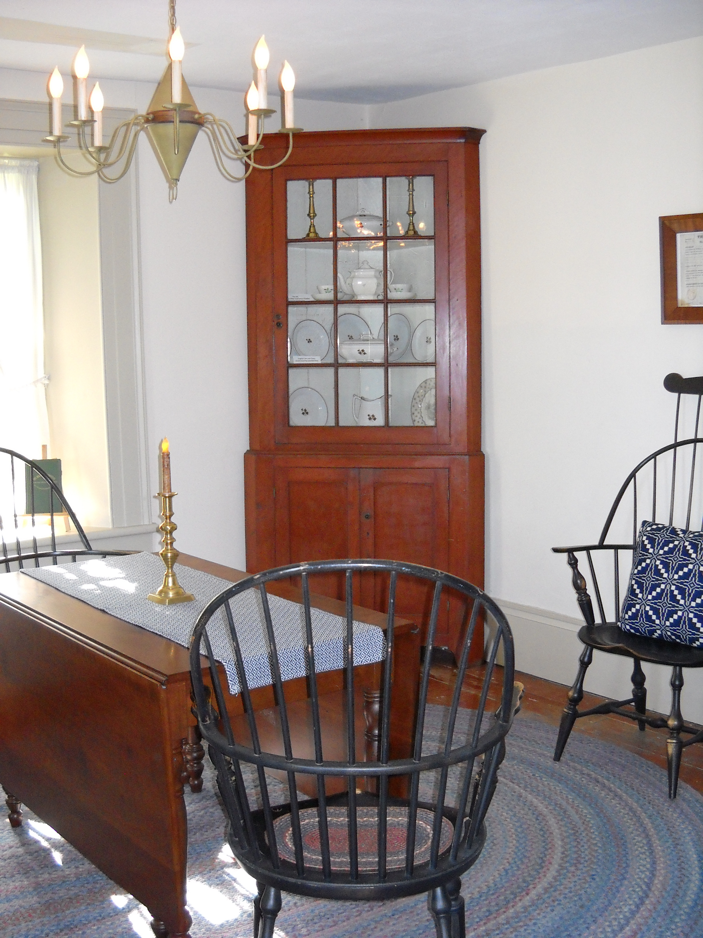
I’m in the middle researching and writing several multi-part Clark House Historian posts, so no essay today. How about a sunny photo of the Clark House parlour, instead?
Photo by Reed Perkins, 2015. Click to open larger image in new window.
The cherry gate-leg drop leaf table dates from about 1850, and is used at Jonathan Clark House Museum board meetings. The bow backed Windsor chairs are based on 1840s originals. These reproductions date from around the 1940s or so.
The cherry corner cupboard is from about 1840. The finish and most of the glass are original. The tea leaf pattern china and twig pattern tea set in the parlour cupboards were donated by local antiques collectors. And the period reproduction light fixture was made in a small shop in Vermont.
Recent Monday: Map Day! (here, here) posts have focused on Mary Clark’s family—and her father Peter Turck and brother James B. Turck— as Mary and her children made the transition from rural life in Mequon to a home in the city of Milwaukee in the early 1860s. Today we backtrack a bit and look at some developments in the state of Wisconsin in the early 1850s.
The 1850s was a crucial time for many early Washington/Ozaukee county settler families. A few of the younger settlers were drawn West by the 1849 Gold Rush. A handful stayed in California, most returned home. Some—such as Mary Clark and her brother James B. Turck—decided that the city would be a better place to live and to raise and educate their children. Others, including more than a few of the early “Yankees” that had arrived from New England and New York state in the late 1830s and early 1840s, got the itch to sell out, take a profit and move on. Many of these went “West.”
Going West
In the 1850s, “Going West” meant different things to different people. For some, it meant the opportunity to buy large parcels of fine prairie farmland in nearby counties such as Fond du Lac, Waukesha and Walworth. For others, going west meant adventures in the lead mines and Mississippi River ports of southwest Wisconsin. And some would not stop at the Mississippi, eventually moving on to newly opened lands in Minnesota, the Dakotas and beyond, With that in mind, take a look at today’s map:
UPDATED February 9 & 11, 2025, to correct the year and date of Fred. Beckmann’s death and investigate the apparent errors on his gravestone (see updated images, text, and especially Note 4, below).
Farming the Clark place, 1868-1873
In our previous post we saw that sometime around 1861/62, Mary Clark and her children decided to move to Milwaukee. By the time the MilwaukeeCity Directory for 1862 was published, Mary—and, we presume, her children—were living together with Mary’s father Peter Turck, at 474 Jefferson in the city.
We also know that Mary and her daughters did not sell the Mequon farm—to Catherine Doyle—until April, 1872. So, for over a decade, someone besides the Clark family was living and working on the Clark property. Most likely, Mary made some kind of tenant-farmer arrangement where someone grew crops on the Clark land and paid rent to Mary from the proceeds. This could have been a very useful source of income for Widow Clark and her seven children during the 1860s. Unfortunately, we don’t have much documentation of who the tenants may have been and what sort of arrangement Mary may have made with them.
The Doyle Family
In the same post, I also erred in assuming that the John and Catherine Doyle family probably farmed the Clark land throughout the 1860s. Clark House museum director Nina Look recently called my attention to information about the Doyles and their neighbors in various maps and census schedules created around 1870 that shows that the Doyles were living and farming elsewhere in Mequon through most of the 1860-1870 decade. In future posts I will look at those maps and census schedules and try and make more sense of where the Doyles lived and what land they may have farmed prior to purchasing the Clark farm in April, 1872.
Nina also reminded me that I forgot one important person that we know did farm the Clark farm: Fred Beckmann
A Closer Look at the 1860 Census: Checking Ages and Dates
As we did for their 1850 census, I thought we should do the math and check whether the enumerator got everyone’s correct age on the Clark family’s 1860 census schedule. And do the ages agree with the Clark “Family Record” and other Clark family documents and known facts, including their 1850 census schedule?
First, examine the Clark’s 1860 census page header. It was enumerated by Assistant Marshall (for the census) Hugo Boclo and covered the “Free Inhabitants in the town of Mequon in the County of Ozaukee State of Wisconsin enumerated by me, on the 20th day of July. 1860.”
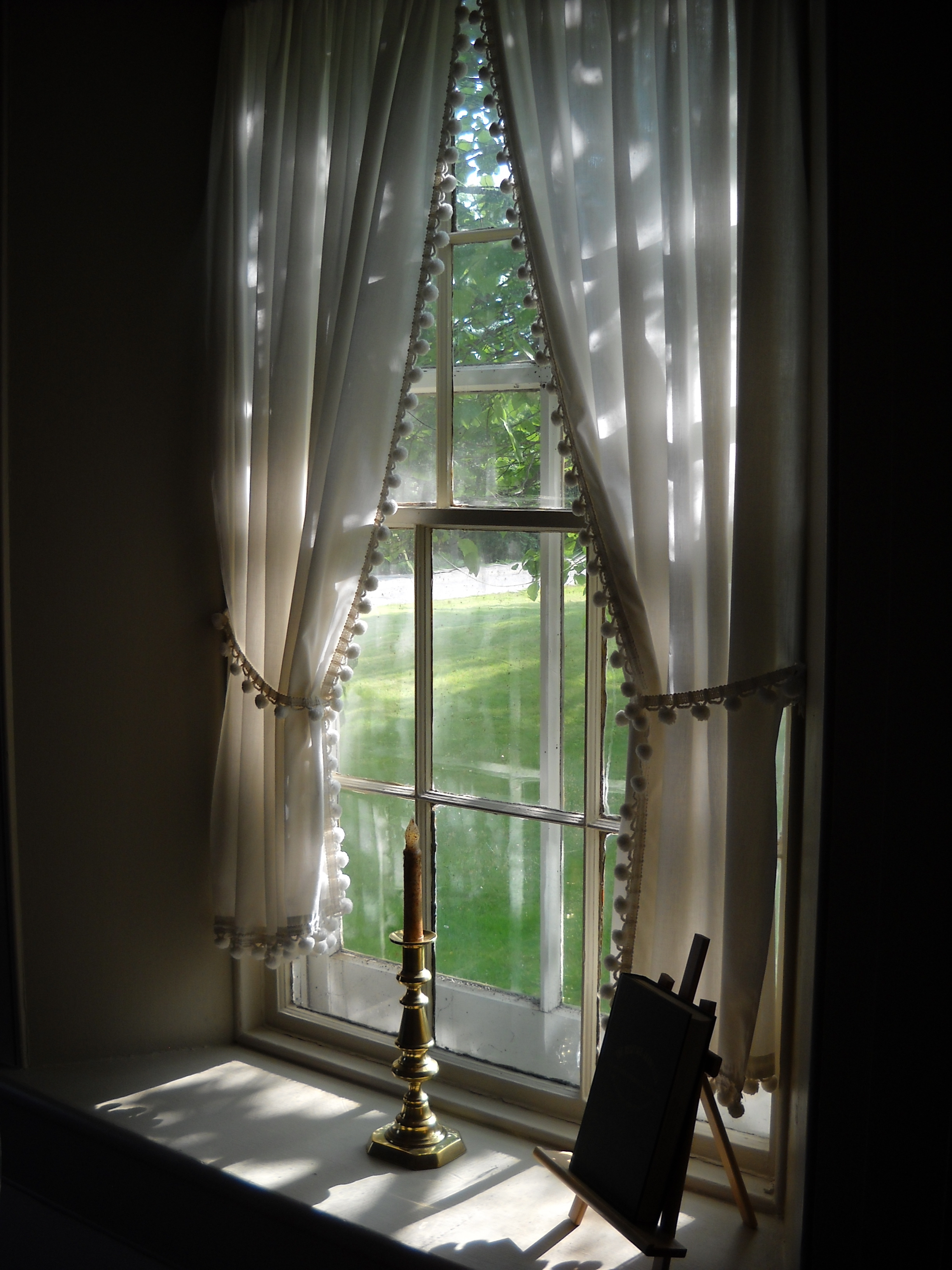
There’s a lot going on behind the scenes at Clark House Historian these days. I’ve got a half-dozen blog posts in various stages of completion, plus ongoing research and information-checking projects with Nina Look, Liz Hickman, and others. And, I’ve just heard from a third-great-granddaughter of two of the original Mequon settler families! How cool is that? More on those folks in an upcoming post—or two!
So let’s take a break, and enjoy a relaxing summer view from the Clark House. In this instance, a lovely July, 2015, view from the Clark’s front parlour, looking to the southwest toward present-day Bonniwell Road. According to the 1872 “Shoolmap” of Mequon, neighbors John Kurz and J. H. Townsend lived just across the street. A bit farther west down the road were—still—the farms of old friends and original Mequon settlers William Bonniwell and Jesse Hubbard.
Photo by Anna Perkins, used by permission. Click to open larger image in new window.