Autumn in “the West” – 1841

Hey! Fall fell on Wednesday, September 22, this year, and I missed it. (Just having too much fun blogging about How’d they get here? Detroit to Ft. Howard, 1834, I suppose.)

These days—living and working inside our climate controlled, electrically illuminated spaces—it’s easy to miss nature’s seasonal changes. But you can be sure that our early Clark House residents, friends, and neighbors didn’t miss the start of autumn. Rural life was—and is—centered around the progression of the seasons, and autumn brought new farm and household chores to suit the changing weather and decreasing daylight.

So pile up your haystacks, sharpen and oil your tools before you store them in the barn, fill up the root cellar with food for the next six months or more, and keep chopping firewood for the winter woodpile. It’s time to mark the end of summer and the start of fall with a handsome seasonal image from the Clark’s era:

Autumn, No. 4: Gigantic sycamores. An ox team crossing the ford. Owl Creek, Ohio

Continue reading

How’d they get here? Detroit to Ft. Howard, 1834 (part 2)

More Great Lakes Tourism – Summer, 1834

Our series of “How’d they get here?” posts is written to illustrate the nuts and bolts of how our early Mequon pioneers travelled from their original homes or ports of arrival in North America to the newly opened federal lands in Wisconsin Territory, circa 1830-1850. Today’s post continues our previous post, a first-person description of 1830s frontier tourism that we called How’d they get here? Detroit to Ft. Howard, 1834 (part 1).

Picking up where we left off…

Wednesday, July 16, arrival at Green Bay

On Wednesday, as the Sun was slowly sinking to its repose in cloud of the most gorgeous and variegated colors, we arrived at the extremity of Green Bay, and about two miles up the Fox river, we landed at Navarino,2 receiving as we passed a salute from Fort Howard, on the opposite side of the river.

Detail, Topographical map of Wisconsin Territory / compiled from the Public Surveys on file in the Surveyor General’s office … by Samuel Morrison, Elisha Dwelle [and] Joshua Hathaway, 1837. American Geographical Society Library Digital Map Collection, University of Wisconsin–Milwaukee. Click the detail map to open a larger version in a new window. Click here for a link to the complete map at UW-M and its bibliographic information.

This map detail—showing Fort Howard, Navarino and, at the top, the southern end of Green Bay— is from the Topographical map of Wisconsin Territory, published in 1837 and the subject of a Monday: Map Day! post in December, 2020. As a reminder, this 1837 map shows all the lands officially surveyed by the federal government up to the time of publication. In 1837, the territory to the north and west of the Fox and Wisconsin rivers was still reserved for Wisconsin’s Native Americans, so the lands to the north and west of the Fox River are left (mostly) blank on this official map. But this land was not at all “empty.” The Indians, the forests, the wildlife, some of the old Métis and Anglo-American settlers—and the army—were all on the left bank of the Fox River in 1837, as they were in 1834, when the steamboat Michigan and its passengers arrived in Green Bay.

Continue reading

How’d they get here? Detroit to Ft. Howard, 1834 (part 1)

Our series of “How’d they get here?” posts is written to illustrate the nuts and bolts of how our early Mequon pioneers travelled from their original homes or ports of arrival in North America to the newly opened federal lands in Wisconsin Territory, circa 1830-1850. Today’s post looks at another trip to Ft. Howard on the steamboat Michigan, this time in the summer of 1834.

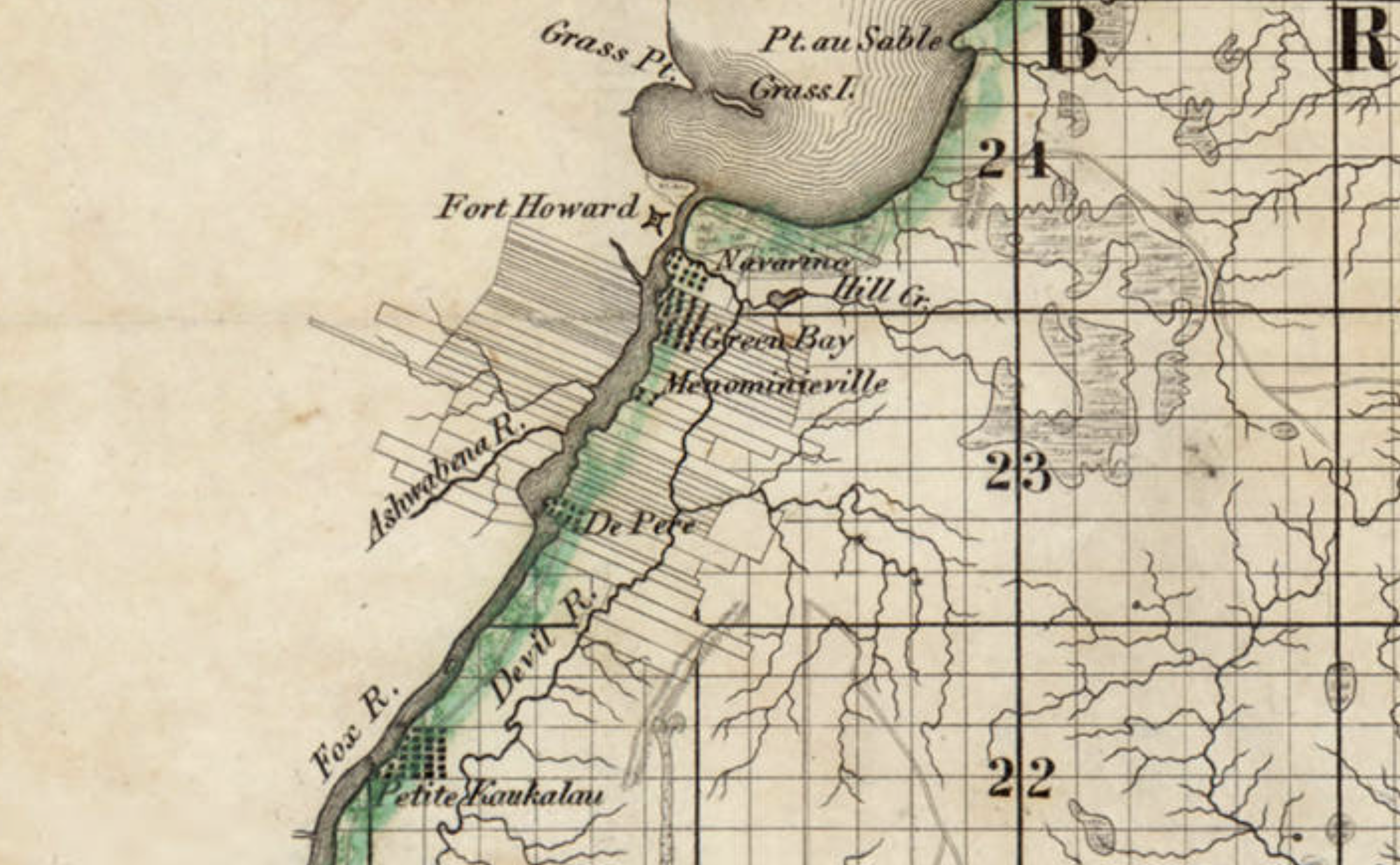
In Monday’s How’d they get here? – JMC to Ft.Howard, 1833, we looked at the likely probability that from October 16 – 30, 1833, Pvt. Jonathan M. Clark left the U.S. Army’s recruiting depot at Ft. Niagara, New York, and traveled the Great Lakes from Buffalo, New York, to his new post at Fort Howard, Green Bay, Michigan (later Wisconsin) Territory. To make that late-season journey the army chartered the new and lavishly appointed steamboat Michigan.

Great Lakes Tourism – Summer, 1834

Less than a year after that October, 1833, voyage the owners of the Michigan announced two special excursions to the “Far West” for the summer of 1834. The first of these was scheduled to leave Buffalo on Thursday, July 10, headed to “the Sault St. Marie (foot of Lake Superior), Michigan and Green Bay, touching at the ports on Lake Erie and at Detroit,” and would “embrace a distance of nearly 2000 miles, during which, passengers will have an opportunity of viewing the splendid scenery of Lakes Erie, St. Clair, Huron, Superior and Michigan, and the rivers, straits and bays connected with them.”

“Steamboat excursion to the Far West,” advertisement, Albany Argus, June 6, 1834, page 3, via genealogybank.com. Click to open larger image in new window.

The second trip would depart Buffalo on August 12th, and would take in all the sights of the July trip, and additional notable points along the south and east coasts of Lake Michigan, including Chicago, Michigan City, “St. Josephs,” and the mouth of Michigan’s Grand River. What could an 1834 tourist to the “Far West” expect on such an excursion? We have a first-hand report from the July trip, which includes an eventful stop at Jonathan M. Clark’s post at Ft. Howard.

Continue reading

River walk

There was still some daylight left after the annual “Pie on the Patio” event at the Clark House last week, so I thought I’d stop by Mequon’s historic Isham Day House on my way home. Isham Day was one of Mequon’s first settlers, and he built his tidy home, sometimes known as the “Yankee Settler’s Cottage,” in 1839. It’s a town landmark, and I’d never been to see it.

While enjoying my first look at the Day House, I also took the opportunity to meander through the adjacent Settlers Park. It’s a beautiful little park, with an accessible boardwalk that leads down to and along the west bank of the Milwaukee River. It’s a short, easy stroll; I highly recommend it. By the time you reach the riverbank you’ll forget you are in a busy 21st-century downtown.

Photo credit: Anna Perkins, 2021. Click any photo to open gallery and access larger versions of the images.

Continue reading

Taking a short break…

It’s been a busy summer here at Clark House Historian, with lots of research, writing, editing, and posting, and most of the essays illustrated with unique historical maps, documents, and images. And more Clark House history posts are queued up in draft form, awaiting final touches.

I don’t know about you, but I’m ready for a short break, starting with a cool drink while watching the birds in the backyard. Here’s one frequent visitor to our house:

Havell, Robert, engraver, after John James Audubon, Yellow Bird or American Goldfinch, 1828, plate 33 from The Birds of America (1828-1838), hand-colored engraving and aquatint on Whatman wove paper. National Gallery of Art, Gift of Mrs. Walter B. James. Public domain. Click to open larger image in new window.

Continue reading

Steaming against the wind…

Ahoy, readers! Here’s another “bonus” post for our ongoing series “How’d they get here?” If you need to catch up, the series began with our July 6, 2021 post Monday: Map Day! – How’d they get here? and continues from there.

I’m working on the next two (or three) more substantial installments of the series, metaphorically steaming against the wind through virtual piles of documents, books, and historical images. It’s going well, but taking a bit longer than I hoped. So while you’re waiting, how about another beautiful Great Lakes ship image, this time courtesy of the National Gallery of Art in Washington:

[American artist, 19th century], Steamship Erie, probably 1837, oil on canvas, National Gallery of Art, Gift of Edgar William and Bernice Chrysler Garbisch. Public domain. Click to open larger image in new window.

Continue reading

Preparing for planting

Revised May 13, 2022 to correct spelling of Nathaniel Currier’s name.

It’s mid-May in southeastern Wisconsin, and with luck the last frost is behind us. For the past weeks and months farmers and gardeners have been tending to the soil and preparing for planting. At this time of year in the 1840s and ’50s, Jonathan M. Clark would have done much the same, hitching up his team of oxen to a steel-bladed plow to cut and turn over the tough prairie grasses and break up the soil of his newly-cleared lands.

Continue reading