Today’s post is another installment in our new series about the life of Alfred Bonniwell, youngest son of Mequon’s Bonniwell family, and brother-in-law of Jonathan and Mary (Turck) Clark. If you missed them, our first installments are here and here. Although I—and others—have written quite a bit about the Bonniwells in Mequon, Alfred and his family have remained something of a mystery. It’s time to try and fix that. So for the next few posts our focus will be on Alfred Bonniwell, his life and descendants, as described in contemporary documents.
Alfred Bonniwell’s earliest record
The earliest record of Alfred Bonniwell that I have seen is an index of his 1826 baptism.1 It includes this information:
Name: Alfred Febbett Bonniwell Christening Date: 7 May 1826 Christening Place: St. Mary’s, Chatham, Kent, England Father’s Name: William Bonniwell Mother’s Name Eleanor Bonniwell
Other, later, records indicate that Alfred was born on April 1, 1826. A baptism in the following month or so—such as on May 7th, 1826—would be pretty typical for Anglican parish baptisms of the period. So the date, as well as the names of the parents, are consistent with what we already knew about Mequon’s Alfred Bonniwell.
I’m gotten a good bit of research done on my Alfred and Sarah (Turck) Bonniwell project this week, but time (and focus) to write and edit posts has been at a premium. So while I’m still writing and editing, here’s a historic Bonniwell-related image for your enjoyment.
Chatham Dockyards, c. 1763-1789
Mitchell, Thomas (1735-1790), Chatham; view from a height over a dockyard with man-of-war being repaired at centre, a building with a clocktower at right and another building at right, brush drawing in grey wash, with watercolor, over graphite. Copyright, Trustees of the British Museum, (CC BY-NC-SA 4.0 license). Click to open larger image in new window.
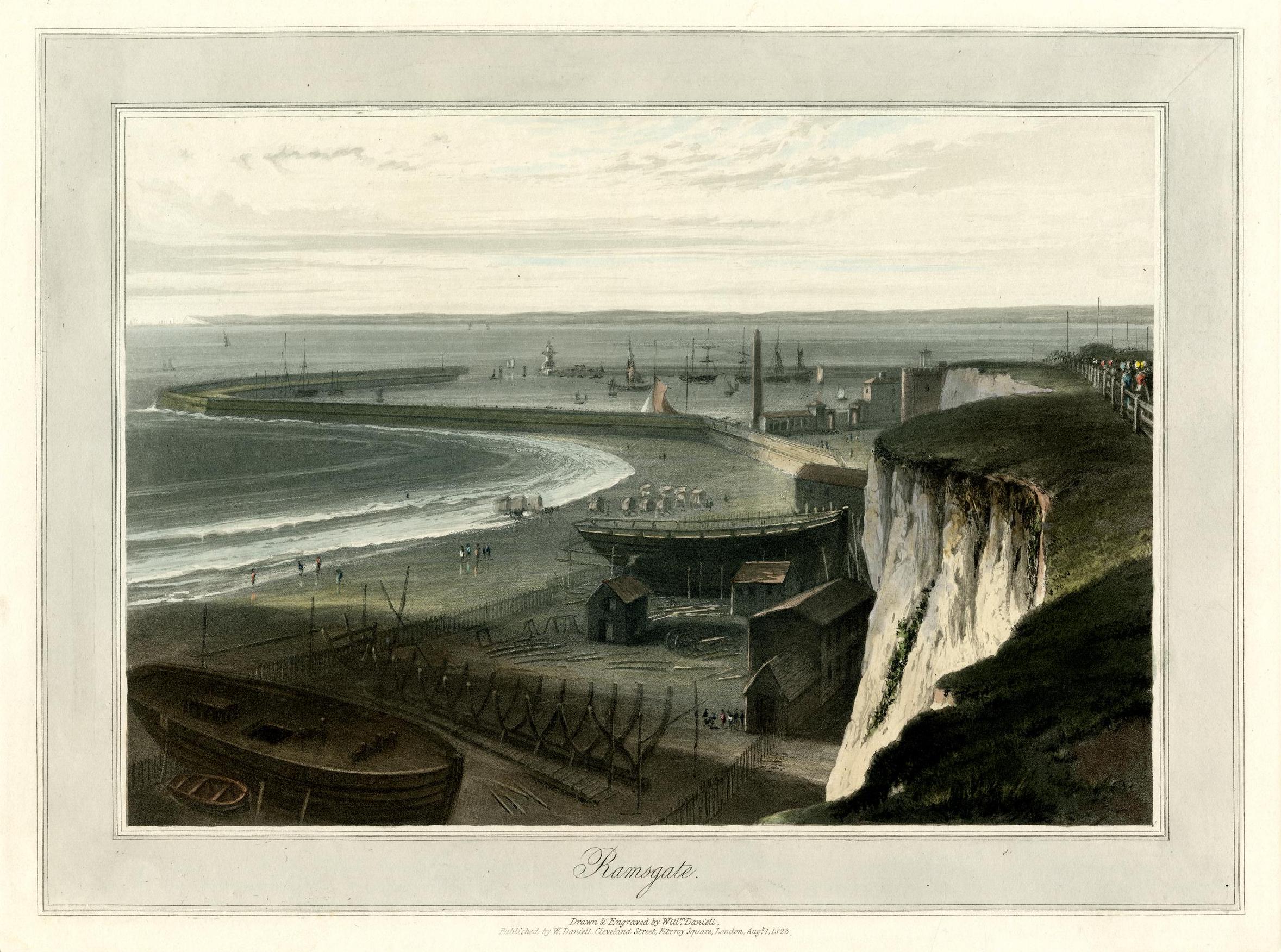
We’ve mentioned Whitehall, New York, on several occasions. Located just east of the south end of Lake Champlain, the town of Whitehall has long claimed to be the “Birthplace of the U.S. Navy.” More importantly for our story, in 1823 Whitehall became the northern terminus of the Champlain Canal, connecting the Hudson River and the Erie Canal to Lake Champlain and points further north.1
Port of Entry
More importantly for our story, Whitehall served as an international port of entry for immigrants coming to New York and New England from Canada and overseas via the St. Lawrence River and Lake Champlain. In the early 1830s, these immigrants included Jonathan M. Clark, who came from Lower Canada in April, 1831,2 and the entire Bonniwell family, who arrived the following year.3
What did our immigrants of 1831 and ’32 see just before they stepped ashore in the United States? The hustle and bustle of a major harbor and center of commerce such as New York, Boston or Philadelphia? Er, no. Instead, this is what greeted our intrepid newcomers:
Whitehall, Lake Champlain
Milbert, Jacques Gerard, Amerique Septentrionale – Etat de New-York. N. 21, pl. 1…White Hall, Lake Champlain, Lithograph by Bichebois and Adam, Paris, 1828–1829. Yale Art Gallery, Mabel Brady Garvan Collection. Public Domain. Click to open larger image in new window.
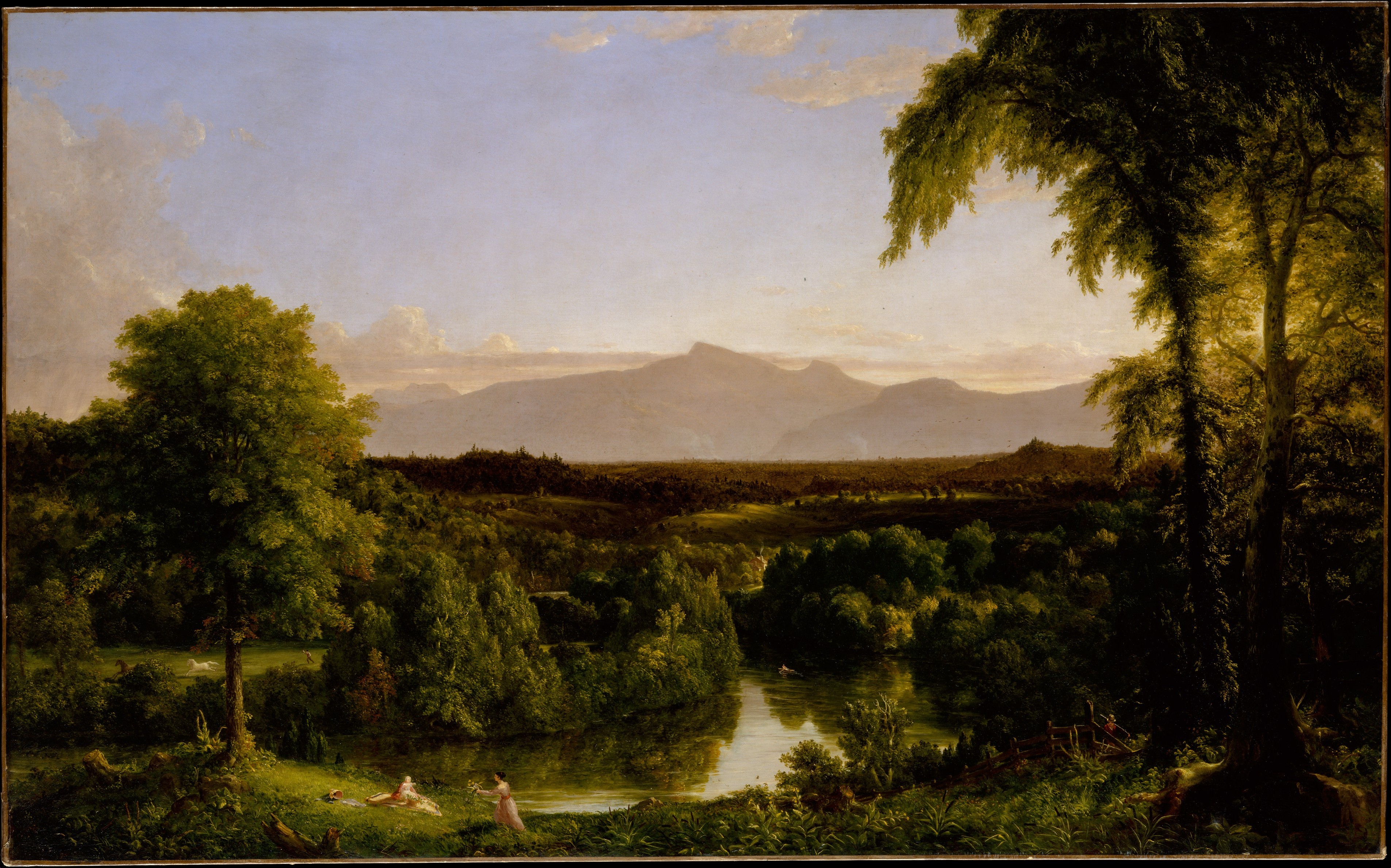
I’m still catching my breath after writing Thursday’s big post on the life of Caroline Clark’s mentor, John G. McKindley. We’ll return to Caroline (Clark) Woodward, and see how her time with McKindley influenced her adult life and work, in just a bit.
In the meantime, here’s a lovely fall scene that would have looked very familiar to Mary (Turck) Clark’s mother Rachael (Gay) Turck, and to Rachael’s Gay and Van Loon / Van Loan parents and ancestors:
Cole, Thomas, View on the Catskill—Early Autumn, 1836-1837. The Metropolitan Museum of Art, New York, gift in memory of Jonathan Sturges by his children, 1895. Public domain. Click to open larger image in new window.
UPDATED, Oct. 4, 2021, with a few minor edits and to add an additional footnote.
I’m still working on some longer posts; they should be ready soon. Meanwhile, I thought you might enjoy two lovely images, beginning with this nineteenth-century print, a view that would have been very familiar to a surprising number of our early Mequon immigrants:
More on JMC’s path from New York to Fort Howard, 1833
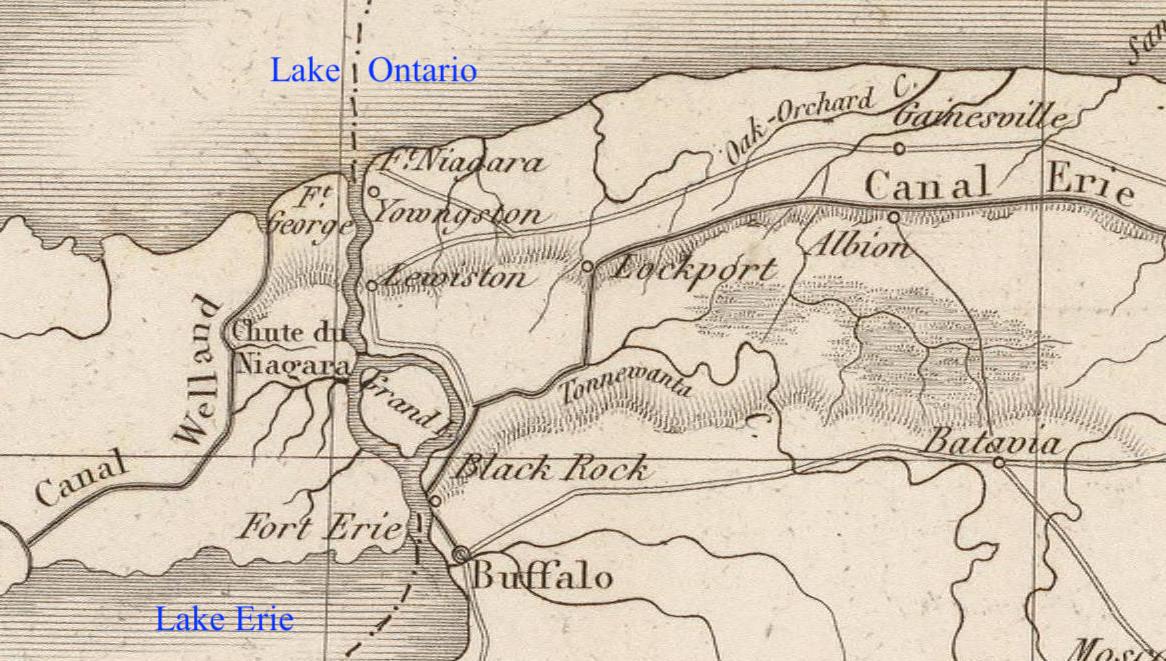
In our post How’d they get here? – JMC to Ft.Howard, 1833., I surmised that new army recruit Jonathan M. Clark mustered in at Ft. Niagara, New York, and then went from there to join his regiment at Fort Howard, Green Bay, Michigan (later Wisconsin) Territory. I’ve since discovered two newspaper items that support that surmise. Here’s one from Spring, 1833, about five months before JMC signed his enlistment papers in Utica, New York:
[Recruits travel from Ft Niagara to Buffalo], dateline Buffalo, May 22, reprinted in [Philadelphia] Daily Chronicle, May 29, 1833, page 3. genealogybank.com. Click image to open image in new window.
On May 22, 1833, ninety fresh U.S. Army recruits marched from the army’s personnel depot at Ft. Niagara to “Tonawanta,” presumably the New York village of Tonawanda, located where Tonawanda Creek, the final stretch of the westbound Erie Canal, meets the Niagara River:
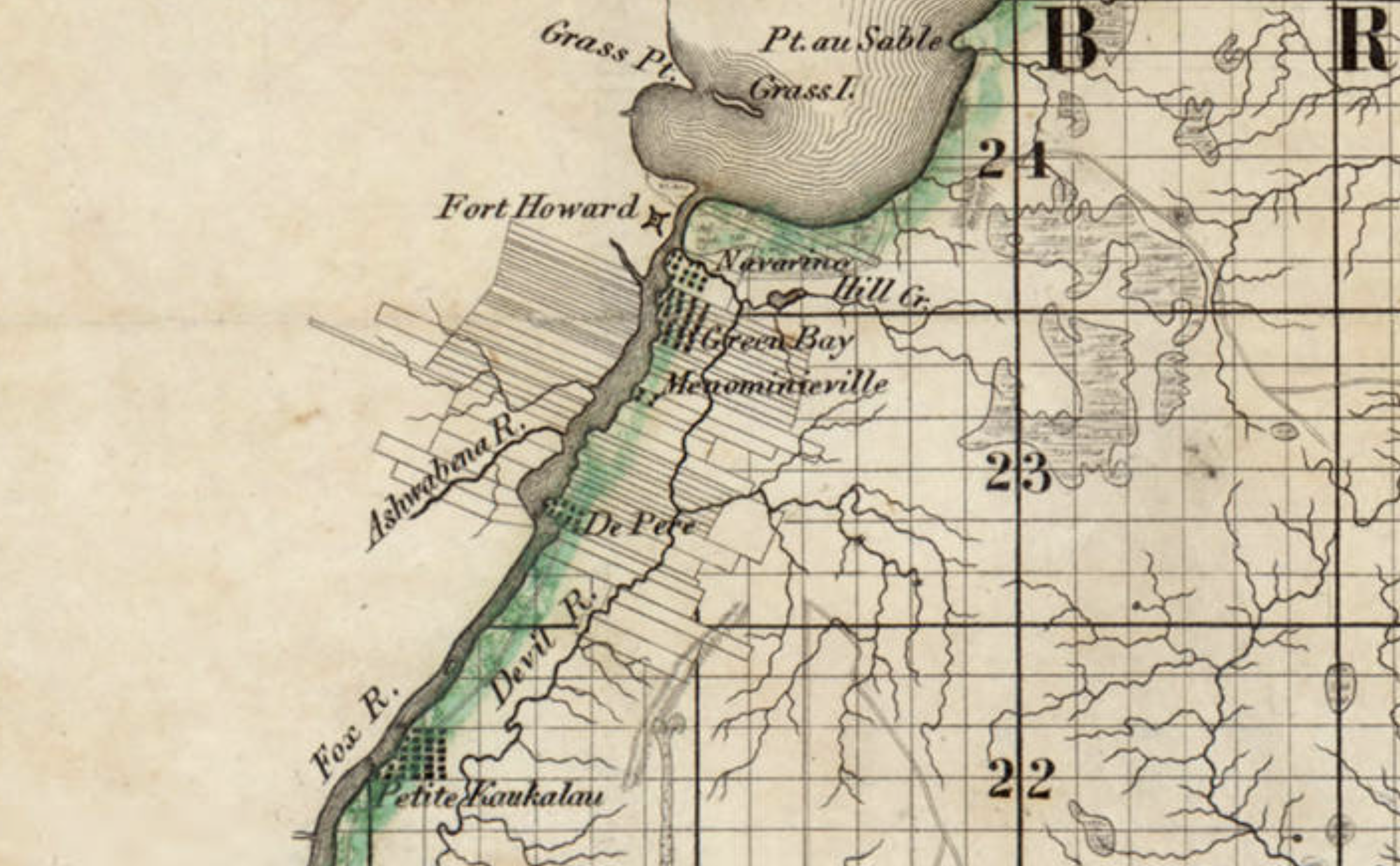
Last time, we illustrated our look at Ft. Howard with this detail from the first widely-available map of Wisconsin—and the first map of the territory based on official surveys—published in 1837:
Detail, Topographical map of Wisconsin Territory / compiled from the Public Surveys on file in the Surveyor General’s office … by Samuel Morrison, Elisha Dwelle [and] Joshua Hathaway, 1837. American Geographical Society Library Digital Map Collection, University of Wisconsin–Milwaukee. Click the detail map to open a larger version in a new window. Click here for a link to the complete map at UW-M with full bibliographic information.
This detail—showing Fort Howard, Navarino and, at the top, the southern end of Green Bay—was the subject of a Monday: Map Day! post in December, 2020, and gives a good picture of the topography and settled areas along the final miles of the Fox River as it empties into Green Bay. But on closer look, the details of the fort and its layout are very vague, limited to one X-shaped symbol. For a better understanding of Fort Howard in its most active era, we need to look at the actual 1823/1827 federal survey upon which the 1837 map was based:
Private Claims at Green Bay, 1823/1827
Detail, [Title section] of map, Private Claims at Green Bay, surveyed in July, Aug.t & Sept.r 1823; see image of complete map for full citation. Click to open larger image in new window.
Our series of “How’d they get here?” posts is written to illustrate the nuts and bolts of how our early Mequon pioneers travelled from their original homes or ports of arrival in North America to the newly opened federal lands in Wisconsin Territory, circa 1830-1850. Today’s post continues our previous post, a first-person description of 1830s frontier tourism that we called How’d they get here? Detroit to Ft. Howard, 1834 (part 1).
Picking up where we left off…
Wednesday, July 16, arrival at Green Bay
On Wednesday, as the Sun was slowly sinking to its repose in cloud of the most gorgeous and variegated colors, we arrived at the extremity of Green Bay, and about two miles up the Fox river, we landed at Navarino,2 receiving as we passed a salute from Fort Howard, on the opposite side of the river.
Detail, Topographical map of Wisconsin Territory / compiled from the Public Surveys on file in the Surveyor General’s office … by Samuel Morrison, Elisha Dwelle [and] Joshua Hathaway, 1837. American Geographical Society Library Digital Map Collection, University of Wisconsin–Milwaukee. Click the detail map to open a larger version in a new window. Click here for a link to the complete map at UW-M and its bibliographic information.
This map detail—showing Fort Howard, Navarino and, at the top, the southern end of Green Bay— is from the Topographical map of Wisconsin Territory, published in 1837 and the subject of a Monday: Map Day! post in December, 2020. As a reminder, this 1837 map shows all the lands officially surveyed by the federal government up to the time of publication. In 1837, the territory to the north and west of the Fox and Wisconsin rivers was still reserved for Wisconsin’s Native Americans, so the lands to the north and west of the Fox River are left (mostly) blank on this official map. But this land was not at all “empty.” The Indians, the forests, the wildlife, some of the old Métis and Anglo-American settlers—and the army—were all on the left bank of the Fox River in 1837, as they were in 1834, when the steamboat Michigan and its passengers arrived in Green Bay.
Our series of “How’d they get here?” posts is written to illustrate the nuts and bolts of how our early Mequon pioneers travelled from their original homes or ports of arrival in North America to the newly opened federal lands in Wisconsin Territory, circa 1830-1850. Today’s post looks at how Jonathan M. Clark may have made the trip west to Wisconsin in October, 1833. And, in the process, we correct an important, but incorrect, date in the JMC timeline.
Jonathan M. Clark heads west…
Back in June, 2016, I outlined what we knew about Jonathan Clark’s 1833 enlistment in the army and subsequent journey to Green Bay:
After enlisting in the Army in Utica, New York, on September 19 and confirming his enlistment on September 28, 1833, Jonathan was sent to one of the Army’s “general depots.” I’ve not yet established which one he went to; the most likely places were the Jefferson Barracks in St. Louis, Missouri, or Kentucky’s Newport Barracks, on the south side of the Ohio River, across from Cincinnati. It’s possible that Jonathan may have reported to another “depot,” perhaps Ft. Niagara, New York, which was the home base of JMC’s recruiter, Capt. Clitz.
In any case, less than a month later Jonathan arrived at Fort Howard, Michigan [later Wisconsin] Territory. Fort Howard was the headquarters of the army’s Fifth Regiment, with easy water access via Lake Michigan to Ft. Dearborn, Chicago and, via the Fox and Wisconsin rivers, to Forts Winnebago and Crawford.
Now that we know more about early transportation routes from New York to Wisconsin it seems unlikely that JMC reported to either the Jefferson Barracks or the Newport Barracks before arriving at Fort Howard. Yes, it would have been relatively easy to travel from Utica, New York, to either the Jefferson or Newport barracks via the Erie Canal to Lake Erie, and then the Ohio canals and Ohio river. But Fort Howard was one of the army’s northernmost posts. If JMC had been shipped to one of the main personnel depots in Kentucky or Missouri, the northward trip from either place to Green Bay and Ft. Howard would have been needlessly long and difficult.
Fort Niagara
I now suspect that Jonathan Clark mustered in to service at Fort Niagara, New York.2
Map detail, showing western New York state, including Ft. Niagara, the Erie Canal, and Buffalo, from Poussin, Guillaume-Tell, Travaux d’ameliorations interieures projetes ou executes par le Gouvernement General des Etats-Unis d’Amerique, de 1824 a 1831 … Atlas. Paris, Anselin, Libraire, pour l’art militaire, les sciences et les arts, […],1834. Imprimerie de Lachevardiere, rue du Colombier, No. 30. Credit, David Rumsey Map Collection, David Rumsey Map Center, Stanford Libraries, non-commercial use permitted under Creative Commons license. Click image to open larger image in new window.1
Previously, we turned our thoughts to the historic city of New Orleans, and the disastrous impact of then-ongoing Hurricane Ida. Once again the Crescent City was hit by a major hurricane. Ida has since moved on and lessened in intensity, but leaves in its wake significant wind and water damage; over one million Louisiana residents are currently without electricity, gasoline, and fresh water, and it looks like it will take weeks to restore services. We wish a speedy recovery for all those in the affected areas.
I have a more-than-passing interest in New Orleans because our Clark House family has ties to the city; Mary (Turck) Clark’s brother, Joseph Robert Turck (1823-1902), spent most of his adult life there.
New Orleans, Louisiana Sugar and Rice Exchange, c. 1891. Source and credits, below (note 1). Click to open larger image in new window.
Joseph R. Turck
Like his big sister Mary, Joseph R. Turck was born in Athens, Greene county, New York. He was about five years old when the family moved to Wayne county, New York, and about fourteen years old when the family migrated west to Mequon in 1837.
In February, 1845, Joseph purchased 40 acres of his father Peter Turck’s Mequon land.2 Joseph did not keep it long; he sold it back to his father in September of the same year. What happened next? We’re not sure. But by 1848 Joseph had left Wisconsin and relocated to New Orleans.