1857: Disaster

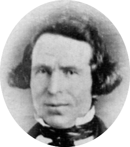
As the year 1857 began, things seemed to be going well for the Clark family. Jonathan M. and Mary Turck Clark had been married for seventeen years. On May 25, 1857, they welcomed the birth of their eighth child, daughter Jennie Marietta Clark. She joined six older sisters—Caroline, Elizabeth, Persie, Theresa, Laura and Josie—and one brother, Henry.

The family had been living in their handsome, two-story home of stone and wood—now the Jonathan Clark House Museum—for nine years. They owned 160 acres of fine farmland, and appeared to be one of the more successful and comfortable farm families in the area.

But not all was well in the neighborhood. In November, 1856, typhus struck Rev. James W. Woodworth’s father, Peter. By late December, Rev. Woodworth’s daughters Rosetta and Julietta were both ill with the disease. In early February, Rev. Woodworth’s wife, Cerena Loomer Woodworth was taken ill with typhus, followed by daughter Sophia a few days later.

Continue reading

Census Records for the In-Between Years: 1838

UPDATED, July 24, 2021 with another spelling and additional info on early settler S. McEvony-McEvery-McEvany.

The Second Wisconsin Territorial Census

The second Wisconsin territorial census, taken in 1838, is the only Wisconsin territorial census we have not yet discussed here at Clark House Historian. If you need to catch up, at the end of this post is a list of our previous discussions of Jonathan Clark, Mary Turck, and their family on the federal, territorial and state censuses enumerated between 1836 to 1855.

By early 1838, several new counties—Dodge, Jefferson and Washington—had been created from the original, larger, Milwaukee and Brown counties, although the new counties were still “attached” to Milwaukee county for judicial purposes.1 This means that the 1838 territorial census of the newly-created Jefferson, Dodge and Washington counties was the responsibility of the Milwaukee county enumerator, Sheriff Own (sic) Aldrich.

The filmed images for the second Wisconsin territorial census, enumerated in 1838, are available online as FHL film no.1,293,919 , aka DGS film 7,897,817 (Item 2, following the 1836 census. The 1838 census begins at image 118 of 532). Here’s the first page of the Milwaukee county census (including the attached counties of Jefferson, Dodge and Washington):

Continue reading

Census Records for the In-Between Years: 1836

Where’s Jonathan Clark?

Wisconsin’s first territorial census was enumerated in the summer of 1836. Our previous Monday: Map Day! post discussed the extent of the Wisconsin Territory in 1836, and outlined the few—very large and lightly populated—counties that were enumerated on that first census. If you missed it, you might want to read that post first.

Today’s post was originally planned to be a quick few paragraphs outlining the 1836 territorial census procedures and explaining how Jonathan M. Clark was, alas, probably not enumerated on this census; and if he had been, then we’d never find him; why that might have been; how this was not unusual for its era; and so forth. But! It turns out that we can find the “family” that Jonathan was enumerated with, though it’s kind of complicated, so bear with me.

The Wisconsin Territorial Census of 1836

The 1836 Wisconsin territorial census was typical for its time and purpose. The sheriff of each county was charged with enumerating four categories of white persons in his area:

  • Number of males under 21 years
  • Number of females under 21 years
  • Number of males over 21 years
  • Number of females over 21 years

There were no pre-printed forms; each sheriff used blank paper, a pen and a ruler to record the data. If you look at the actual returns (available online as FHL film no.1,293,919 , aka DGS film 7,897,817), you’ll find that the enumerators often recorded additional information not required by the authorizing legislation. (The Crawford county sheriff was particularly enthusiastic, subdividing his information into 13 age-groups for white males, 13 age-groups for white females, 6 age-groups for enslaved males and 4 age-groups for enslaved females.) The Brown county sheriff, as you can see (below), remained closer to his legislated mandate, and chose to enumerate five categories of white settlers:

Continue reading

Monday: Map Day! – Wisconsin Territory, ready for its 1st census, 1836

.

The vast Wisconsin Territory originally included all the current states of Wisconsin, Minnesota and Iowa, and that part of the Dakotas east of the Missouri River. The Wisconsin Territory officially existed from July 3, 1836 until the current—and smaller—State of Wisconsin was established on May 29, 1848. The history of the territory prior to statehood, and especially before mid-1836, is complicated. For more information you might begin with this overview. Here’s an outline map of the territory:

[Map of Wisconsin Territory, April 20, 1836] original from Wisconsin Historical Society, Wisconsin Historical Collections, 11, this image from Wisconsin Historical Collections, 13:248.

Section 4 of the April 20, 1836 act of Congress that created the Wisconsin Territory, required that

Previously to the first election, the governor of the Territory shall cause the census or enumeration of the inhabitants of the several counties in the territory to be taken or made by the sheriffs of said counties, respectively, and returns thereof made by the said sheriffs, to the governor.

Act of Congress, April 20, 1836, quoted in Wisconsin Historical Collections, 13:247.

With such a large expanse of land, and relatively small number of white inhabitants, the Wisconsin Territory of 1836 was divided into only a few counties. Two of these, Dubuque and Des Moines counties, lay to the west of the Mississippi river and comprised the Iowa District of the Wisconsin Territory. (Both were enumerated in the 1836 territorial census, but I’ll let Iowa history fans follow up on those counties.) Here a map of the 1836 Wisconsin Territory counties lying east of the Mississippi River:

Continue reading

Census Records for the In-Between Years: 1855 — Part 2

Who’s On That 1855 Census Page?

This is a follow-up to our previous post about the Jonathan M. Clark family and the 1855 Wisconsin state census. You might want to read that post first, and also take a look at our recent discussion of English/Latin and German Kurrent hand writing styles as used in places like Wisconsin in the 1800s.

In the comments to that 1855 state census post, blog reader and Clark House friend Liz Hickman asked:

Am curious about the others listed on the page; starts with James Woodworth [Rev.?]. Do you see any other names of interest? Can you figure out the name below Jonathan’s?

Liz Hickman, reply to Census Records for the In-Between Years: 1855

Thanks again, Liz, let me see if I can help. First of all, let’s take a look at that first page of the Mequon return for the 1855 state census:

Continue reading

Census Records for the In-Between Years: 1855

A Growing Family in a Growing State

The late-1840s and early-1850s were boom years for Wisconsin settlement. The final territorial census was enumerated in 1847, and statehood arrived in 1848. The seventh decennial federal census was taken in 1850. (If you’re late to the party, we covered the Clark family and the 1850 census here, here, here, here and here.) And in 1853, the seven easternmost townships of old Washington county were established as Ozaukee county.

Such rapid growth called for frequent changes in political boundaries and representation. To make that happen, a number of state censuses were produced during the years between decennial federal censuses. The first of these was officially enumerated on June 1, 1855. The “Jon. M. Clark” family appears on line 20, page 1 of the Enumeration of the Inhabitants of the Town of Mequon, in Ozaukee County, State of Wisconsin […] taken by me, Wm. Zimmermann, Town Clerk.

Continue reading

Monday: Map Day! – Mequon’s First Survey, 1836-1837

I love maps, all kinds of maps. I especially like comparing various maps of the same area as it changes over time. I have collected a number of maps that illuminate various aspects of Clark family and Clark House history, and I thought I’d start posting some for you all to use and enjoy.

Fortunately, we are in a digital golden age of historical maps, many available for free download and use. Among the best sites are the online map collections at the Library of Congress and the New York Public Library. Take some time to click the links and browse.

But today’s map comes from another source, the Bureau of Land Management’s General Land Office website. Previously, we discussed the BLM/GLO as the go-to site for land patent indexes with exact descriptions and images of government land patents issued in the 30 Public Lands States. Click the link to start at the BLM/GLO homepage, then click on “Survey Search.” That will take you to this page:

Notice how “Surveys” is highlighted in black text in the left side column. For a sample search, I’ve entered “Wisconsin” as a state, and the exact town and range numbers for the Town of Mequon (T9N-R21E). Click the orange “Search Surveys” button, and you’ll get this results page:

Continue reading

Census Records for the In-Between Years: 1846

Our previous Clark House Historian post was an introduction to the Wisconsin territorial and state censuses, with a close look and complete images of Washington county’s pages from the 1842 census. If you missed that, or need a refresher on how to navigate the FamilySearch.org collection of (free!) census images, please read Part 1, here.

The focus of today’s post is the next Wisconsin territorial census, officially enumerated on June 1, 1846. It is available as FHL film number 1,293,920, aka DGS film number 8,117,163. Click one of the film numbers to navigate to the 1846 census images. The Washington county census page images begin on image number 922 of 1103

For this census, Washington county was divided into two districts, each with its own enumerator. Patrick Toland was the enumerator for District No. 1, the western division, consisting of the towns of Erin, Richfield, Germantown, Wright, Polk, Jackson, Addison and West Bend. His summary of the enumeration was placed at the front of the census folder (images 923-925). The essential results for District No. 1 are here, image 924 of 1103:

Continue reading

Census Records for the In-Between Years: 1842

Don’t Forget the (Free!) Territorial and State Censuses

Although they are not as informative as the decennial federal censuses, Wisconsin’s territorial and state census returns can offer useful information about the growth and development of places—such as Mequon—and can add to what we know about a family—like the Clarks—and their neighbors at various times between the once-a-decade federal census population schedules. For a nice explanation and overview of federal, territorial and state census history in Wisconsin, please go to the Wisconsin census FamilySearch.org wiki page. This is an invaluable first stop for locating these records. Be sure to peruse the lists of which records have been preserved for which counties; not all census records have survived. And the Wisconsin Historical Society has a similar page of useful Census Research Tips

The FamilySearch.org Wiki page is kept pretty current, but there have been a few changes that may not be reflected there yet. In one positive development (especially for the safer-at-home researcher), it appears that all of the microfilmed state and territorial censuses are now viewable—at no cost—via the FamilySearch.org portal. (Note that you will have to use a free account to be able to view the digitized images online. So create an account if you don’t already have one, and login before you search the indexes and click the links for the multitude of digitized microfilms.)

Here are some links and tips to speed your search. For the FamilySearch.org index, click here: United States, Wisconsin online census collections. You should land on a page that looks like this:

Continue reading

The “E” is silent – as in “Clarke”

A “New” Jonathan M. Clark Document, a New Line of Inquiry, and a Friendly Reminder…

Take a look at the following name as written by a professional U.S. land office clerk in three different places on land patent no. 19687, from 1848:

Patent No. 19687, Jonathan M. Clark(e)? #1
Patent No. 19687, Jonathan M. Clark(e)? #2
Patent No. 19687, Jonathan M. Clark(e)? #3

What to you think? Jonathan M. Clark or Clarke? Is that a silent “e” at the end of “Clark,” or just a looping flourish? Whoever indexed this document at the Bureau of Land Management’s General Land Office website1 thought it was Clarke. Is it a big deal? No. Given that the GLO has been digitizing and indexing hundreds of thousands of pages of maps, survey notes and patent documents for the last decade or two, we can’t expect that the indexers can cross-reference each name on each patent and check for consistent spelling. And besides, 19th-century spelling is notoriously capricious anyway.

On the other hand, maybe the indexer could have looked at the end of the document and compared the “K” in “Clark” to the “K” at the end of this signature, representing our eleventh President:

Continue reading