Today’s Monday: Map Day! revisits and makes a correction to an interesting map that we first discussed here on October 29, 2017, and then re-visited on July 11, 2020. And for unknown reasons, that original 2017 post—according to my monthly WordPress statistics report—was the most-viewed post on this site for the month of January, 2024, with 341 views (!).

Burr, David H. Map of the Northern Parts of Ohio, Indiana and Illinois and Michigan and that part of the Ouisconsin Territory lying East of the Mississippi River, 1836, detail of title & author. Library of Congress.
The 2020 re-post was originally conceived as a kind of addendum to our June-July, 2020, multi-part discussion of the earliest Wisconsin territorial, state, and federal censuses. It also served to locate Jonathan M. Clark in Wisconsin Territory during his U.S. Army service from September, 1833, to September 19, 1836.
Today’s post includes one particular correction that I’ve been meaning to make for a while. When I added my original annotations to a detail of this map (in red), in 2017, I made an error. I mislabeled Sgt. Jonathan M. Clark’s location at the time he mustered out of service, a temporary army camp along the under-construction military road from Fort Howard (Green Bay) to Fort Winnebag0 (Portage). JMC’s muster-out location was always referred to in the records of the Fifth Regiment of Infantry as “Camp Hamilton.” For some reason, when I made my annotated detail map, I incorrectly labeled this place “Ft. Hamilton.” A minor error, but worth correcting , especially now that this map is receiving fresh attention.1
It’s 1836. Where’s…Wisconsin?
In September, 1836, Sgt. Jonathan M. Clark was discharged from the U.S. Army at “Camp Hamilton,” Wisconsin Territory, after serving his three-year term of service with Co. K, Fifth Regiment of Infantry.2 One year later, in the autumn of 1837, Jonathan’s future wife Mary Turck would make the long trip from Palmyra, New York, to Milwaukee and finally Mequon, Washington County, Wisconsin, with her parents Peter and Rachael Turck and six younger siblings. By the end of 1840 Jonathan and Mary would be married and starting their family in Mequon.
That seems simple enough, until you take a moment to wonder how much Jonathan—or especially Mary and her family—knew about this new Wisconsin Territory. Jonathan had been in the territory since October, 1833, mostly on post at Ft. Howard. In the last year or so of his service he was busy cutting trees and building bridges for the military road along the Fox River waterway from Ft. Howard (Green Bay) towards Ft. Winnebago (near modern Portage). As a road-building soldier, Jonathan might have done some surveying and seen—or helped draw—a variety of maps of the military road and its vicinity. But for a better overview of this new territory, Jonathan or Mary might have sought out a map such as this:
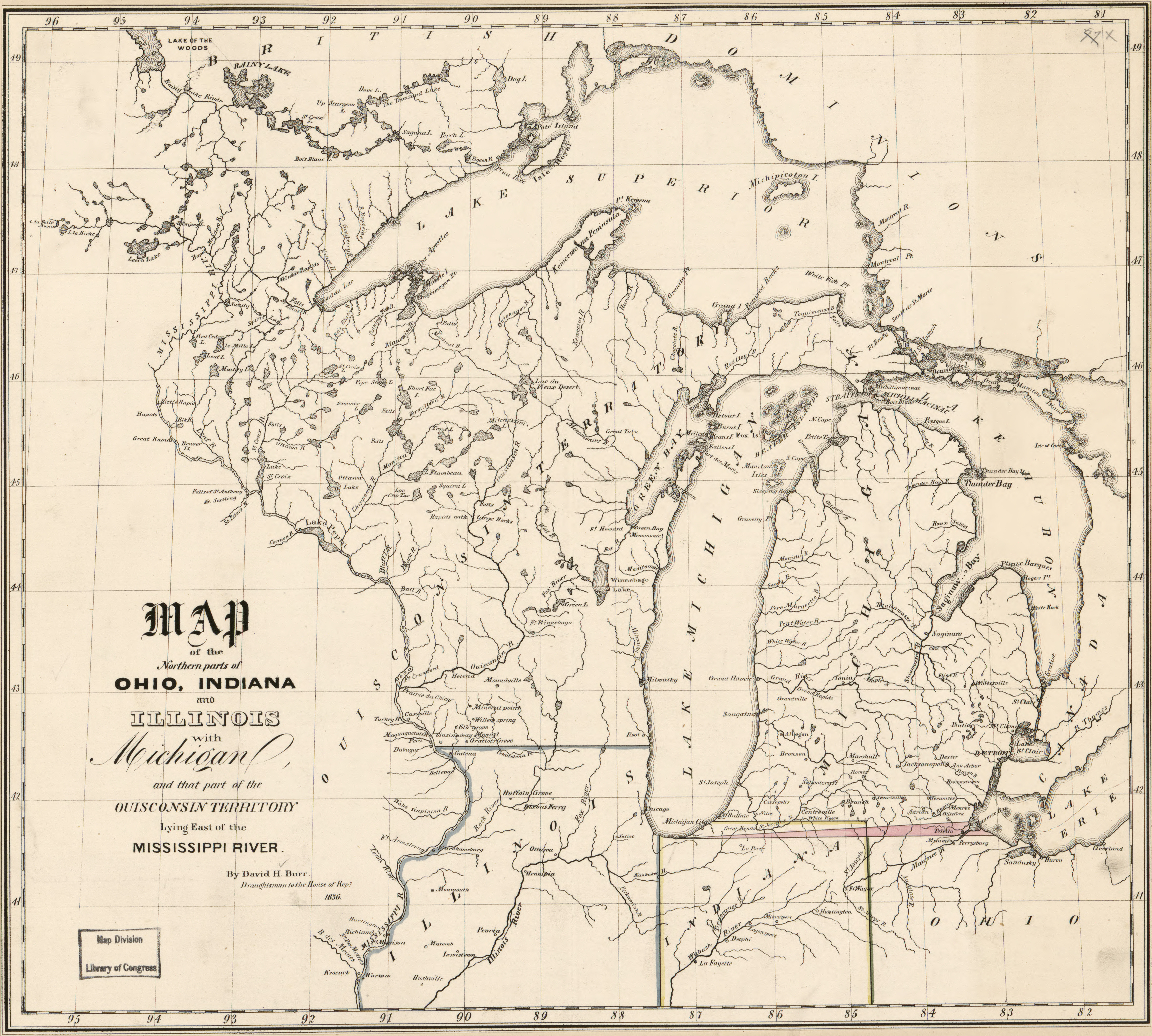
Burr, David H. Map of the Northern Parts of Ohio, Indiana and Illinois and Michigan and that part of the Ouisconsin Territory lying East of the Mississippi River, 1836. Library of Congress. Click image to open larger map in new window.3
Where are the people?
In January, 1837 Michigan would become a state. In July, 1836—in preparation for statehood—its western counties were split from it to form the Wisconsin Territory. This 1836 map shows only that part of Wisconsin Territory that lies east of the Mississippi River (at that time the territory also included all of present-day Iowa and Minnesota, and those parts of North and South Dakota that lay east of the Missouri River). In studying this map, the main impression is that—as of 1836—there was not much settled in this part of the Old Northwest except for a few army outposts, built and garrisoned to maintain the peace with the indigenous peoples and to develop roads and other communications as white Americans pushed westward.
But there were already plenty of people living in Wisconsin. Along with the new white settlers, a large number of Native American peoples still lived in the territory, including the Menominee, Ojibwe (Chippewa), Potawatomi, and Ho-Chunk (Winnebago). They had been there for centuries, their earliest presence dating back almost 10,000 years. In the 1830s, in preparation for opening southeast Wisconsin lands for sale, the federal government negotiated with various tribal leaders, and they had agreed to move their indigenous peoples to the northwest, beyond a line running roughly from Green Bay in the northeast to Prairie du Chien in the southwest. In reality, a number of Native Americans remained in southeast Wisconsin throughout the era of white settlement (and to the present day, for that matter). With only a few exceptions—such as the “Menomonie” village just south of Ft. Howard/Green Bay, none of these native peoples are represented on this 1836 map.
Where’s…Ouisconsin?
Not surprisingly, the spelling of place names has not been standardized yet. Ouisconsin? That’s how the earlier French explorers, trappers and traders transliterated the Native American words for the Wisconsin River. Different spellings, but similar pronunciation in French, English and Native American languages. Milwalky for Milwaukee is an interesting spelling; a more frequent alternative used in this era is Milwaukie.
To get a better sense of what Jonathan and Mary might have understood of their future home in the mid- to late-1830s, see this annotated detail of the southeast part of the new territory:
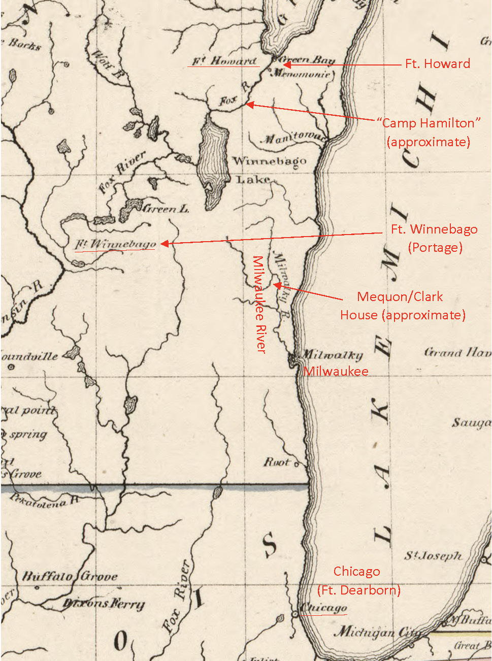
Burr, David H. Map of…Ouisconsin…1836. (detail, corrected to show “Camp Hamilton” instead of “Ft. Hamilton.”) Click on image to open larger map in a new window.
I have added a few notes in red. The three U.S. Army forts garrisoned by Jonathan’s 5th regiment (Forts Dearborn, Howard, Winnebago) are marked. Jonathan was garrisoned at Ft. Howard for the duration of his 1833-1836 enlistment. I have also noted the very approximate location of Jonathan’s discharge from the army in September, 1836. This “Camp Hamilton” was not an official army post but was, instead, a temporary work camp for the the 5th regiment’s Cos. G, I and K, as they cut trees and built bridges for the military road, somewhere upstream of Ft. Howard on the Fox River. I have also indicated the approximate location of the Jonathan Clark House Museum.
Most modern readers will look at the map and note how empty it looks, and wonder how many places on the map must have seemed—to the white settlers of that time—vast, unknown, even forbidding. Some European Americans found this intimidating and stayed where they were, “back East.” Others, like Jonathan Clark and Mary Turck and her family, saw opportunities and headed West.
_______________________
- I have gone back and updated the map and text of those October 29, 2017, and July 11, 2020, posts so that the information is correct for future readers. I believe this annotated detail map of “Ouisconsin” may found in some other CHH posts as well. I’ll try and correct them when I find them. Please let me know if I’ve missed one.
- For more on Jonathan Clark’s final summer with the army, see Census Records for the In-Between Years: 1836. Links to other CHH posts describing Jonathan Clark’s army years can be found here.
- Technical note: these maps from the Library of Congress digital map collection are free to all and available in a variety of scanning resolutions and file sizes. For technical reasons (i.e., WordPress does not like JPEG2 files), I have uploaded a decent-quality JPEG of the map that will enlarge nicely after you click the map to open it in a new window. If you would like to see this and other maps in all their glorious high-resolution detail, click the link in the caption to the Library’s website and take a look. The JPEG2 scans are very detailed, with modest file sizes, and can be seen and stored with many common applications, such as Apple Preview. For optimal quality and detail, and long-term lossless digital storage, try the TIFF images.

Milwaukee began to be settled in earnest in 1835. William Woodward Sr and Jr were in what would become the Granville area by the end of 1835. Jr. would marry Ms. Clark in 1861 and they would live on the Woodward farm in Granville
Mark Phelps (Great Great Great Grandson of William Woodward Sr
LikeLike
Mark, thanks so much for reading and for your comment. It’s neat to hear from someone with such deep roots in the area.
FYI, I have the beginnings of several new Caroline (Clark) and William W. Woodward (Jr.) posts sketched out, but it will be a while before I can finish them. I’m also working on a project discussing some of those earliest settlers in 1835-1840 or so, and there’s an interesting migration of some early Mequon settlers to neighboring Granville around this time, not far from the Woodward land. Stay tuned for more.
And in the meanwhile, if you missed them, you can enter “Woodward” or “Caroline” into this blog’s SEARCH box and that will give you links to some earlier CHH posts about Caroline Clark and/or her husband W. W. Woodward.—Reed
LikeLike
Pingback: How do you…? A Clark-era handbook | Clark House Historian