Today’s spectacular Map of the Provinces of Lower & Upper Canada.1 was created by Joseph Bouchette, Jr., et. al., and published in London in 1831. It was made as a companion to his father’s exhaustive written description of the same territory, British Dominions of North America, also published in 1831.2
Bouchette, Joseph Jun., Joseph Bouchette [Sr.], et. al., Map of the Provinces of Lower & Upper Canada, London, James Wyld, 1831.David Rumsey Map Collection.3
We are particularly interested in this map as it shows the British possessions in North America—essentially present-day Canada—as they were understood in 1831, the year JMC migrated to New York state, and a year before the Bonniwell family arrived in Lower Canada (Québec). And when compared to Bouchette, Sr.’s great map of Upper and Lower Canada in 1815, it illustrates the rapid growth of British North America, and the Eastern Townships, in the decade and a half since the end of the War of 1812 (1812-1815).
A great map by Joseph Bouchette…Junior
In the Preface to his 1831 book, British Dominions in North America, surveyor general of Lower Canada Joseph Bouchette, Sr., remarked:
The geographical map of the British provinces, and of a section of the adjacent states of the American union, accompanying the work, will, it is hoped, be found an interesting adjunct, from the scope of the country it embraces, as well as an account of the sources of information whence it was compiled. This map was constructed by the author’s eldest son, Joseph Bouchette, Esq., Deputy Surveyor-General of Lower Canada, and must, like the other maps, be left in a great measure to speak for itself. It is but justice to the compiler, however, to mention the extreme laboriousness with which, during three years, he attached himself to its construction, in the midst of active professional duties—the close investigation as to the correctness of documents that preceded their application, and the science with which he was capable of graphically applying the information these documents contained. To this gentleman the author is also indebted for his scientific aid in the compilation of several parts of the topographical maps.
Map key and “Authorities Consulted“
As the detail below makes clear, our map was the product of many hands, most importantly deputy surveyor general of Lower Canada Joseph Bouchette, Jr., with important contributions from the work of his father, surveyor general Joseph Bouchette, Sr., and his predecessor as surveyor general, Samuel Johannes Holland.
Bouchette, Joseph Jun., et. al., Map of the Provinces of Lower & Upper Canada, 1831. Detail, Reference.
The curators at the David Rumsey Collection also provide this additional information on the map and its creators:
Joseph Bouchette Junior carried on his father’s work and this map is a worthy successor to the elder Bouchette’s 1815 map of Upper and Lower Canada. The scale is almost three times as large and the size of the map is doubled. A list of authorities is given, all Canadian, ending with “several important American Authorities” (which are unnamed). Lands belonging to the Canada Company are shown. There is a great deal of detail in the U.S. portions of the map, and attention is paid to the Maine boundary dispute with a note – but only the British claim line is shown. Outline color by state. Map has green cloth edging and is dissected into 35 sections. Folds with blue paper end sheets into a new gray cloth folding case 28×21.5 with “Upper And Lower Canada J. Bouchette, Jr. 1831” stamped in gilt on the spine.
Some useful details
I find this map particularly helpful in keeping track of the changing political divisions of the Eastern Townships during JMC’s time in that area. This is especially useful when wondering where—in which township or county—various government documents or genealogical records might have been created or are presently archived. For example, by 1831 six adjacent and formerly independent Eastern Townships (Potton, Bolton, Stanstead, Hatley, Barnston and Barford) had been incorporated into a larger Stanstead County, while still remaining in the larger [Judicial] District of Montreal.
Bouchette, Map of the Provinces of Lower & Upper Canada, 1831 (detail, County of Stanstead)
As we will see in future posts, a large number of families with the Clark surname migrated from Vermont and New Hampshire to the Eastern Townships circa 1790-1840. Some of them were related to each other, some were not. A Clark family of interest, headed by one David Clark (or Clarke), migrated from New Hampshire to Melbourne township, several townships north of Stanstead. With knowledge of these kinds of migrations in mind, a look at our map suggests we may want to look for Clark settlers in Melbourne and its adjacent townships of Orford, Brompton, Durham, Shipton, Windsor, Stoke, Ascot and Compton, all of which lie in the larger [Judicial] District of Three Rivers, and its subdivision, the Inferior District of St. Francis.4

Bouchette, Map of the Provinces of Lower & Upper Canada, 1831 (detail, Stanstead County & adjacent townships)
Don’t forget Nova Scotia!
As we’ve discussed before, a surprising number of old Washington county’s first white settlers came from the British province of Nova Scotia, particularly from the area around Cornwallis Township, Kings County, N.S. These families included the Strickland, Woodworth, Bigelow and Loomer families. Click the links for lists of related blog posts (and more maps).
Bouchette, Map of the Provinces of Lower & Upper Canada, 1831 (detail, Nova Scotia)
How to get to (and from) the USA
Given our map’s detailed focus on the British possessions in North America, it’s a pleasant surprise to note the level of detail shown in the adjoining parts of the United States. This is an excellent map to use while following the various paths taken by the Woodworth brothers, the Bonniwell family, and Jonathan M. Clark, himself as they cross the international border and migrate to and from Lower Canada and the northeastern United States.
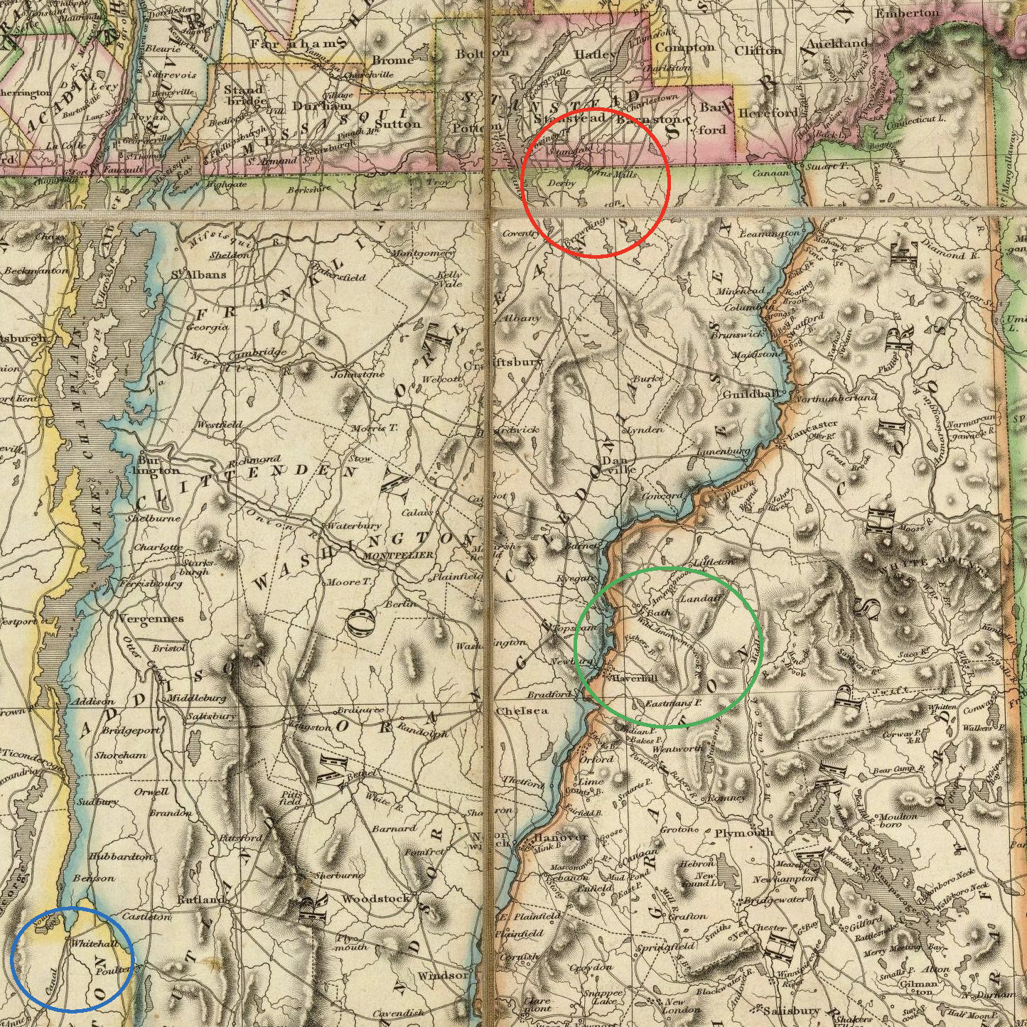
Bouchette, Map of the Provinces of Lower & Upper Canada, 1831 (detail, Stanstead Co and adjacent VT & NH and Lake Champlain areas)
On this detail, I have highlighted three areas that figure prominently in the genealogy and migrations of Jonathan M. Clark and many possibly-related Clark families circa 1790-1840. The red circle encloses the Stanstead, Lower Canada, area and neighborinng northern New England, particularly the town of Derby and surrounding Orleans County, Vermont.
South of Derby, in west-central New Hampshire, I have added a green circle to highlight part of Grafton County, New Hampshire, and some important Clark family hometowns, including Haverhill, Landaff, Bath and (close-by but not shown on this map) Lisbon. We will have a lot of genealogical sorting and charting to do regarding the families from this area that migrated to Stanstead and either stayed in Lower Canada, or returned to Grafton county after a few years. Some of the key families and surnames we will examine are Clark, Rix, Morrill/Merrill and Eastman.
And for a sense of perspective, in the lower left corner of this detail I have highlighted with a blue circle the village of Whitehall, New York, the Empire State’s port of entry at the south end of Lake Champlain and at the north end of the Champlain Canal. Click the links for more about Whitehall’s role in Clark House history.
That’s all for now
I could spend a week’s worth of blog posts discussing the many fine details of this map. I encourage you to open the big map for yourself and take a leisurely look around. And take some time to familiarize yourself with the highlighted areas in the last, large-area, detail map. In just a bit we’re going to start sorting through a lot of documents, land records, and genealogies, and it will be very helpful if we can remember the difference between, for example, Haverhill and Hatley.
P.S. — Another great online map source
Before we go, I’d like to share another outstanding, freely accessible, online map source with you, the Osher Map Library.
The Osher Map Library and Smith Center for Cartographic Education (OML) has been located on the Portland campus of the University of Southern Maine since 1994. Since 2009, it occupies the three-story building at the corner of Forest Avenue and Bedford Street (314 Forest Avenue); it is attached, on the first floor, to the seven-story Albert Brenner Glickman Family Library.
I just discovered the OML this week, and I’ve been searching their online collection—with their well-designed search interface—and finding lots of beautiful, informative, and unique historical maps. The collection is proving especially useful with it’s deep collection of historic maps of New England. Click the link above, and see for yourself!
________________________________
NOTES:
- The full title to our map is: To His most Excellent Majesty King William IVth. This Map of the Provinces of Lower & Upper Canada, Nova Scotia, New Brunswick, Newfoundland & Prince Edward Island, With A Large Section Of The United States, Compiled from the latest & most approved Astronomical observations, Authorities & recent Surveys, Is … most humbly & gratefully dedicated by … Joseph Bouchette Junr. Deputy Surveyor General of the Province Of Lower Canada. Engraved by J. & C. Walker, Bernard Street, Russel Square. Published … by James Wyld … Charing Cross, London May 2nd 1831.
There are two inset maps, titled The British Dominions in North America. and The Gulf Of St. Lawrence, shewing the Geographical position of the Principal Headlands … - The full citation for the map’s companion book is: Bouchette, Joseph, The British Dominions in North America; or a Topographical and Statistical Description of the Provinces of Lower and Upper Canada New Brunswick Nova Scotia the Islands of Newfoundland Prince Edward and Cape Breton. Including Considerations on Land-Granting and Emigration; and a Topographical Dictionary of Lower Canada; to Which Are Annexed the Statistical Tables and Tables of Distances. London, Longman, Rees, Orme, Brown and Green, 1831. Online, two volumes digitized as one at Internet Archive, accessed September 5, 2023.
This massive book (almost 1300 pages), published only 16 years after its 1815 predecessor, documents the many rapid changes in political geography, settlement, and economic development of the British Empire in North America. There is updated information about Stanstead and the neighboring townships. The book includes the lovely 1827 drawing of Stanstead by Bouchette. For reference, 1831—the year this book was published—was also the year JMC emigrated to New York. - Our high-resolution copy of Bouchette, Jr.’s, Map of the Provinces of Lower & Upper Canada, 1831, comes to us via the irreplaceable David Rumsey Map Collection. The Rumsey staff have provided this additional detail about a subsequent printing: A later enlarged edition was published in New York by Sherman & Smith in 1846 (see our #5071), reprinted with additions in 1852, 1853 (no significant changes)(see NMM 479 for an atlas edition of the map, 1853).
I have also admired a very beautiful presentation copy of this map at the online Royal Collection Trust website. I highly recommend clicking the link and taking a look at that map although, unfortunately, the map gets rather pixel-y when you try and zoom in for a very close look. For the best close look, click on our map to open a best-resolution copy of the map in a new window, or click on the David Rumsey Map Collection link. - In 1831, all of these towns, except Durham, lay within Sherbrooke County; the town of Durham was part of Drummond County.

You certainly know how to dig deep in your searches.
Thanks.
Nina
LikeLike