OK, this “Monday: Map Day!” is a few days late (and has been updated since posting, see notes 7 & 8). But I needed a bit more time to edit this beautiful and historic map of the County of Kent for you. Kent was home to Mequon’s pioneering Bonniwell family and their kin for almost 150 years, and taking a close look at its geography may prove helpful for understanding the family and its history, including some of the earlier inscriptions in the Bonniwell family Bible.
Cantivm Vernacule Kent, 1665
Let’s begin with a view of the complete, original map. It was made in 1665, just before James Bonniwell (1636-1709) moved his family from Sutton-Courtney, Berkshire, in south-central England, to Kent, in the southeast.1 As always, I encourage you to click the images to view higher-resolution versions of each map in a new window. Take some time to zoom in and out and scroll around. There’s a lot to see, so I’m going to keep the commentary to a minimum.2

This 1665 map, titled Cantivm Vernacule Kent [Cantium, in the vernacular, Kent], is part of a much larger work, Joan Blaeu’s magnificent Atlas Maior Sive Cosmographia Blaviana, published in Amsterdam between 1662-1672. This is another amazing map made available online by the David Rumsey Map Collection, whose staff provided this commentary:
Blaeu’s 11 volume Atlas Maior is considered by many to be the greatest atlas ever published, both in its own time and even today. It excels in comprehensiveness, engraving, color, and overall production. […] Bound as issued in vellum stamped in gilt with Blaeu device. […] This copy is from the National Library of Scotland and we are grateful to them for providing scanned images of the atlas as part of a joint project under the guidance of Christopher Fleet, Senior Map Curator at the NLS. For more information on Joan Blaeu and the Atlas Maior, see the National Library of Scotland website. 3
Lathes and Hundreds
If you examine the general “look” of this map of Kent, you’ll see that the county of Kent is divided into five large regions called lathes. Wikipedia explains:
The lathe was an ancient division of Kent and originated, probably in the 6th century, during the Jutish colonisation of the county. There exists a widespread belief that lathes originally formed around the royal settlements of the Kingdom of Kent. By the late Anglo-Saxon period they seem to have become purely administrative units, each of which contained several hundreds.
The lathe was an important administrative, judicial and taxation unit for 600 years after the Domesday Book. The functions of lathe and hundreds were somewhat similar, with a lathe covering a much wider area. Although never formally abolished, they have no administrative functions today.
The number and names of lathes in Kent varied over the centuries. This 1665 map shows five lathes (L to R. colored yellow, pink, yellow, pink, green): Lathe of Sutton-at-Hone, Lathe of Ayle[s]ford, Lathe of Scraye, Lathe of Shepway and Lathe of Saincte [St.] Augustine. As we’ll see, most of our Bonniwell- and other Mequon-related Kent families have roots in the Kent lathes of Aylesford and, just to its east, Scraye.
Another old English land description found on this map is the hundred. The origins of the term are ancient and not agreed upon. But all English counties are divided into a number of smaller administrative units called hundreds. On this map, Hundred is usually abbreviated HVND. (In that era, in print and manuscript, the letter V was frequently used in place of the letter U.)4
The Bonniwells and related families in Kent, c. 1667-1832
In addition to the fact that old maps are often intrinsically beautiful and fascinating, studying historic maps can be very useful for historians and genealogists. For example, when researching Kent, learning the geography and names of the towns, hundreds, and lathes where ancestors lived and worked can be an enormous help. Political and administrative boundaries change over time; sorting out who lived where, and when, will make finding relevant surviving records that much easier.
A surprising number of our early Mequon settlers have roots in southeast England’s venerable Kent county. The Bonniwells and other settlers from the Ashby, Dunning, Eastree, Hills, Long, Moss, Munn, Smith and Whitehead families all had ancestral roots in Kent, England. Most—but not quite all—of these families are Bonniwell in-laws.
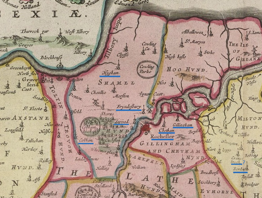
Here’s a detail from today’s map, showing all the Kent place names that I know of (so far) that are cited in various Bonniwell and other family records, from about 1667 to 1832. In this map detail, and the others that follow, I have underlined these relevant place names in blue.
You’ll note that there are two clusters of highlighted town names; one in the center, around Aylesford, and the other further north, around Chatham. Let’s zoom in for more…
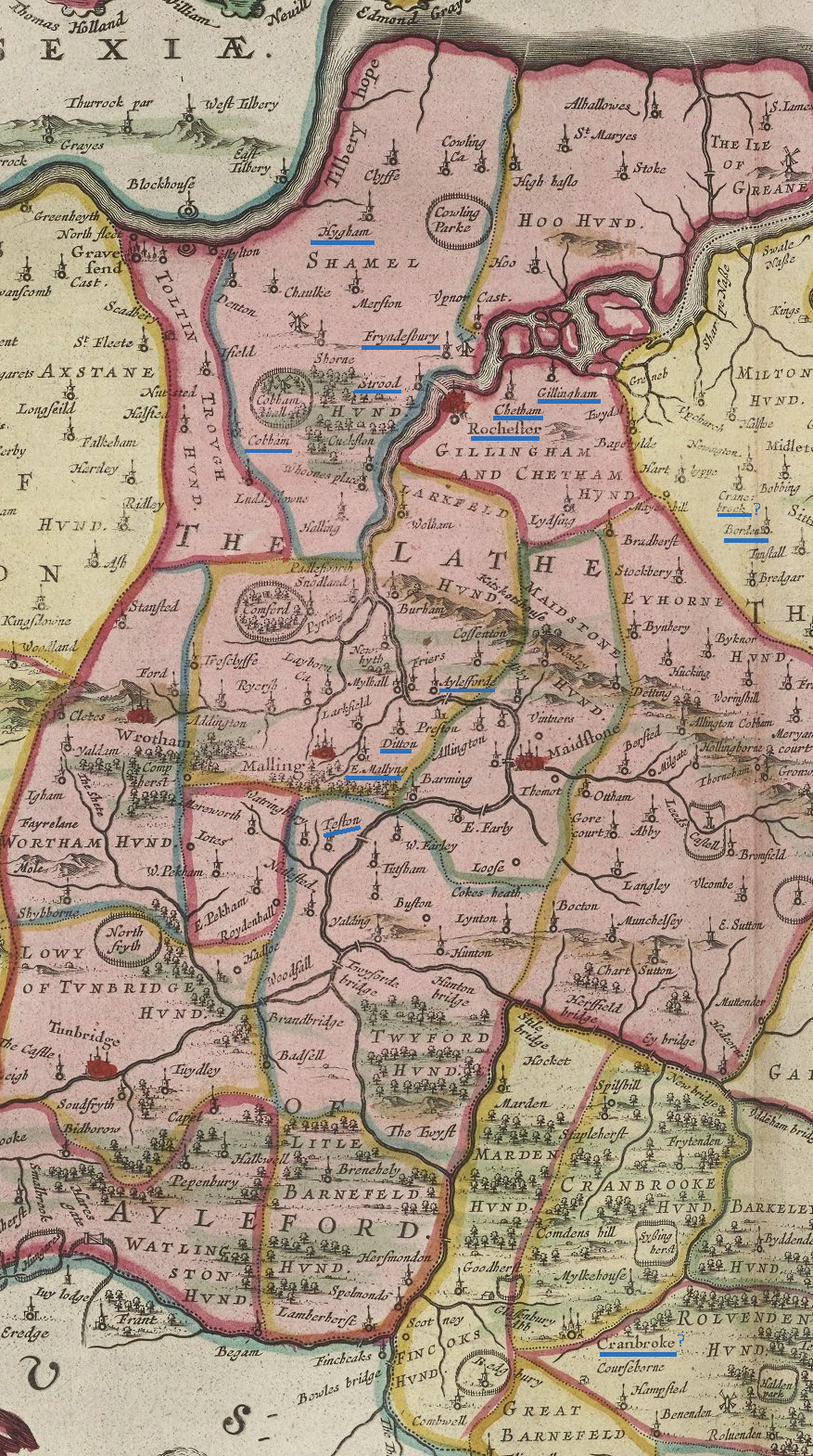
Mapping the Bonniwells, part 1: Aylesford area (c. 1667-1741)
The ancestors of Mequon’s pioneer Bonniwell family migrated from rural Sutton Courtney, in Oxfordshire, to Ditton, Kent, sometime around 1667. After a year in Ditton, the family settled in nearby Aylesford, where they remained until 1741. Inscriptions in the Bonniwell family Bible — now part of the Jonathan Clark House museum collection — show that members of a closely-related branch of the family lived nearby. All the Bonniwell sites from this era are in the Lathe of Aylesford, and primarily in Larkfeld [sic, Larkfield] Hundred.
Ditton was the location of the Bonniwell family’s first home in Kent; son William Bonniwell was born there in 1667. By 1668 the family had moved to Aylesford, just north of Ditton. They would remain there until 1741.
South of Ditton is the village of East Malling, spelled here E. Mallyng. Inscriptions on a page of the Bonniwell Bible record the births or christenings in East Malling of three members of a related branch of the Bonniwell family tree: James Bonniwell (1723), Elizabeth Bonniwell (1725) and George Bonniwell, (1730).
And for the record, another Bonniwell Bible inscription records the marriage of one Elizabeth Bonniwell to John Preblle [sic, Prebble?] at Teston, Twyford Hundred—just south of East Malling—in 1754, some 13 years after “our” branch of the Bonniwell family moved north to Chatham. Elizabeth (Bonniwell) Prebble (sp? born c. August 26, 1792) was one of the younger siblings of William T. B. Bonniwell, future patriarch of Mequon’s Bonniwells.7
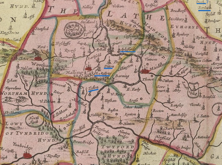
Mapping the Bonniwells, part 2: Chatham area (1741-1832)
In 1741, descendant Thomas Bonniwell (b. 1715) relocated downstream along the River Medway, to the nearby town of Chatham. Chatham was a seafaring village, and home to one of the largest of the Royal Navy’s dockyards and ports. This branch of the Bonniwell family remained in the Chatham area until 1832, when Thomas’s grandson William T. B. Bonniwell (1782-1832)—accompanied by his wife Eleanor (Hills) Bonniwell (1785-1871), most of their living children, several of their spouses, plus a few grandchildren—set sail for Canada and their (unanticipated) future home in Wisconsin.
Almost all of the extant Bonniwell family records from this period were created in or very near Chatham, which lay in the Gillingham & Chatham Hundred in the Lathe of Aylesford. A few other family records from this period were created just across the River Medway in Shamel Hundred, also in the Lathe of Aylesford,
A bit further downstream from Chatham is Gillingham. Thomas Bonniwell (b. 1715) married Mary Eastree there in 1741, and their son, James Bonniwell was born there in 1750. (This James Bonniwell later married Ann Smith; one of their children was William T. B. Bonniwell, future patriarch of Mequon’s Bonniwell family.)
Across the river from Chatham, in Shamel Hundred, are the sites of other Bonniwell family events. Future North American immigrants and parents of Mequon’s Bonniwell settlers, William T. B. Bonniwell and Eleanor Hills were married at Cobham in 1802. Their son Charles Bonniwell (1806-1905) married Sophia Elizabeth Munn (1809-1894) at Higham (spelled Hygham on our map) in 1828. And Charles’s brother William T. Bonniwell (1809-1874) married Catherine Elizabeth Whitehead (c. 1810-1864) at Frindsbury (spelled Fryndesbury, with a long-S).
A few outliers
There is a place name of Cranbrook (various spellings) that may or may not be relevant to one or more Bonniwell family records. It turns out that there are several places in Kent that share the name Cranbrook. Our map shows that in the south of Kent, there is a Cranbrooke hundred. Adjacent to that hundred is the town, parish and/or church of Cranbroke (sic) which, however is not in Cranbrooke hundred, but in Rolvenden hundred. And to further confuse the matter, to the east of Chatham, in Milton hundred, Lathe of Scraye, is a manor house called Cranebrook.5
Just south of the “Cranebrook” manor house in Milton hundred is the church at Borden. This appears to be the place where Alfred Whitehead (1812-1881) was baptized in 1813. Alfred Whitehead married Mary (Turck) Clark’s sister Adamy Turck (1825-1908) in Milwaukee in 1843. It is still not clear whether Alfred Whitehead is or is not related to William T. Bonniwell’s wife Catherine Elizabeth Whitehead (c. 1810-1864).
It is clear that Alfred and Adamy (Turck) Whitehead’s daughter, Emily Mitchell Whitehead (1847-1913), married Eugene C. Bonniwell (1855-1933), the son of Mequon pioneer James Bonniwell (1811-1893) and his wife, Phebe Brooks Capes (c. 1816-1880), some time prior to about 1874. Emily M. Whitehead and Eugene C. Bonniwell had three children, two of whom lived to adulthood. Their marriage did not last; they divorced in 1880.6
The Bonniwell Bible records the death of William T. B. Bonniwell’s sister Ann (Bonniwell) Callow on 15 April 1822, and her burial at “St. Dunstan’s Church Yard.” This is probably the St. Dunstan’s in Cranbrook (to the south, in Rolvenden hundred), but it could be the St.Dunstan’s near the cathedral city of Canterbury.
I’ve also highlighted the location of Strood, across the bridge from the city of Rochester, in Shamel hundred. The main road from London to Chatham passed through the middle of Strood and Rochester, and in the 19th-century soldiers and sailors often marched through Strood on their way to and from the capital and the Royal Navy dockyards. They, in turn, were avid customers for the inexpensive prints and sheets of song lyrics published by Strood’s printers. One such song sheet, celebrating the marriage of King William IV to Adelaide of Saxe-Meiningen in July, 1818, was owned by the Bonniwells and kept folded in the family Bible. That 1818 song sheet, along with a few other Bonniwell family papers that were kept with the family Bible, is now in the collection of the Jonathan Clark House.
Ramsgate
One other Kent locale needs mentioning, the seafaring and shipbuilding town of Ramsgate. It lies at the end of the easternmost tip of the county, in the Lathe of St. Augustine, looking south towards the cliffs of Dover.
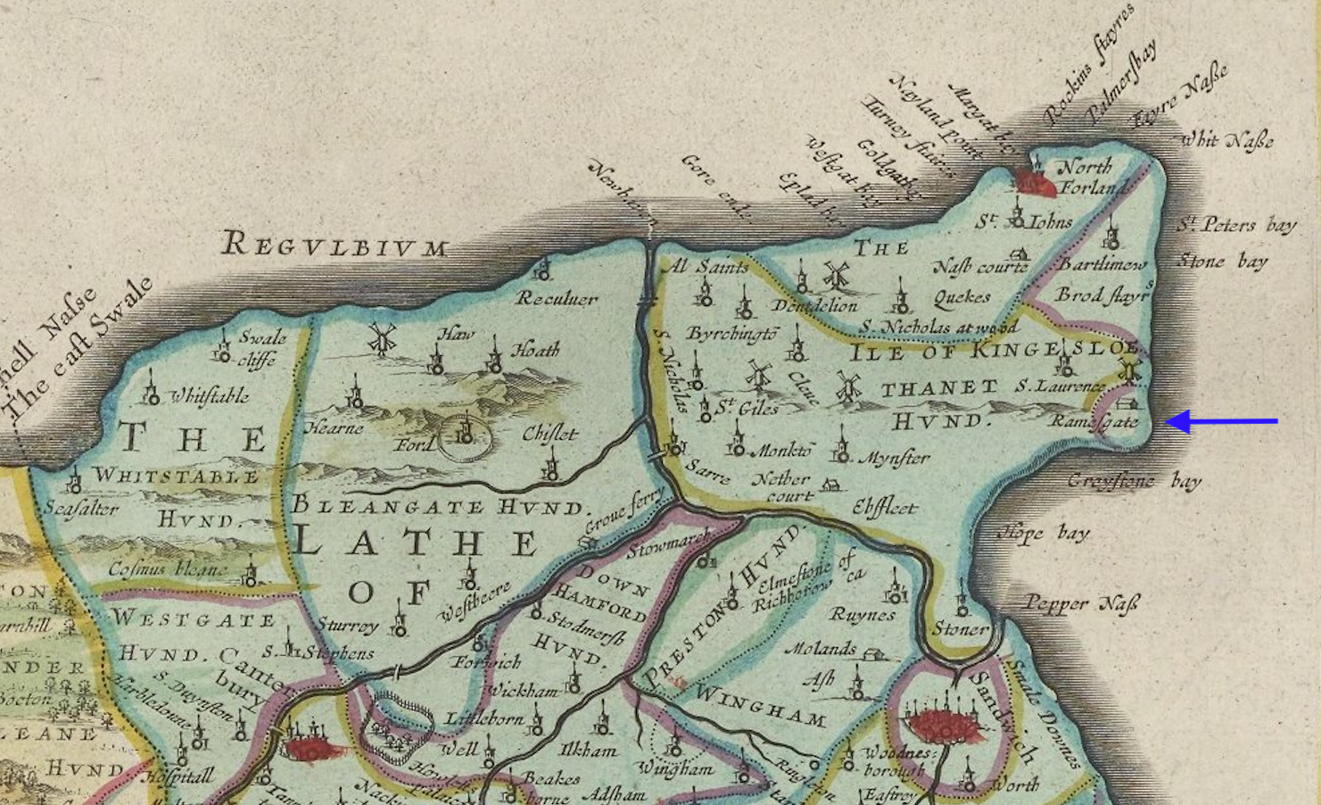
Ramsgate is the probable birthplace of Sarah Ann/Anne Ashby (1834-1891), the future bride of James Byron Turck (1833-1913), son of early Mequon pioneer and civic booster Peter Turck (1798-1872) and younger brother of Clark House matriarch, Mary (Turck) Clark (1821-1881).
A sense of scale
One thing that may not be obvious when looking at today’s map is a sense of scale. You might think that the family’s years spent “in Aylesford” and “in Chatham” meant that getting from one place to another involved traveling substantial distances. Not so. In fact, the Bonniwell’s part of Kent is remarkably compact (by midwestern U.S. standards). Here are some current “maximum” distances, calculated on GoogleMaps:
• south to north, East Malling to Gillingham, via Ditton, Aylesford and Chatham: about 12 miles.
• west to east, Higham to Borden, via Chatham and Gillingham: about 14.5 miles
Even by the standards of their time, the many places in the Bonniwell’s world, circa 1667-1832, were remarkably compact. Yet, like so many families of their time, they remained rooted to their places—Aylesford, and then Chatham—for, in their case, 165 years.8
Phew!
That’s it for now. I hope you enjoyed today’s map and, if your historical or genealogical interests are centered around Kent, I hope you found the post useful. Let me know if you have any questions, comments, or error corrections (with all these names and dates, I must have made a few).
I’ll be back with more Clark House history in just a bit.
______________________
NOTES:
- See Bonniwell, George B., The Bonniwells: 1000 Years (1999), chapters 5 and 6 for the family’s move from Sutton-Courtney, Berkshire, to their subsequent decades in and around Aylesford, Kent.
- I know. Not very likely, but one can aspire to brevity, eh?
- When it was published, Blaeu’s Atlas Maior was a deluxe, high-status, costly item. According to one source, the “final version of the Atlas Maior was the largest and most expensive book published in the seventeenth century.” As such, it is unlikely that any of the Bonniwells knew this map. That we can call up high-quality images of the Atlas Maior—one of the greatest achievements in map making and publishing in history—for free, on our phones and computers, is due to the generous and diligent efforts of the people at the David Rumsey Map Collection and the National Library of Scotland. They deserve our thanks.
- And on a more frivolous note, don’t you think that J.R.R. Tolkien must have seen and known maps like this, before he wrote his tales and drew his maps of Middle Earth? I’m not a Tolkien expert (but I know a few!) and I think the similarities go beyond the general visual style and some shared graphic symbols for geographic features. Tolkien must have absorbed those antique English place and feature names like Lathe and Scraye and Hoo Hundred.
Just for fun, read the following and ask yourself, is this Tolkien describing some mythical land traversed by Hobbits, or a late-18th-century historian writing about a place in Kent, known to Mequon’s pioneer Bonniwell family?
EASTWARD from the hundred of Shamel lies the hundred of Hoo, bounded on the opposite side by the water, called the North Yenlade, which separates this hundred from the isle of Grean. Hollinshed, the chronicler, says, that in his time Hoo was nearly an island, and that there was then a common proverb of this hundred, viz.
“He that rides into the hundred of Hoo,
Besides pilfering seamen, will find dirt enow.”
A very true saying of it at this time. Formerly it used to be noted for the wealth of the yeomen who inhabited it, but there are now few but bailiffs and lookers who live in it, the farmers and occupiers of the lands dwelling at Rochester and Stroud, and elsewhere; nor is there a gentleman’s house, or a clergyman residing, in it, owing to the depth of the soil, the dirtiness of the roads, and the unwholsome air from the neighbouring marshes. It takes its name from its high situation, Hou, in Saxon, signifying an hill.
Alright, it’s not Tolkien. It’s Edward Hasted describing “The hundred of Hoo,” from his The History and Topographical Survey of the County of Kent: Volume 4 (Canterbury, 1798), pp. 1-2. via British History Online http://www.british-history.ac.uk/survey-kent/vol4/pp1-2 [accessed 15 August 2023]. - To further confuse matters, the manor house on our map called Cranebrook, just east of Chatham, in Milton hundred, Lathe of Scraye, is now part of Newington, not south of it as it appears on our map. It seems that at least some of the original manor still exists and has become part of the Newington Manor assisted living facility.
Oh, and Kent has at least three places called Newington. The one discussed here is called Newington, Swale, Kent as it lies in the borough of Swale. Another is farther south, near the Channel Tunnel complex, and is called Newington, Folkestone & Hythe, Kent for similar reasons. The third is a new (post-war) suburb of Ramsgate, and is called Newington, Thanet, Kent. - Yes, the Whitehead-Turck-Bonniwell family tree is a real tangle at the moment. If anyone knows much about the Chatham-Chicago-Mequon/Milwaukee Whitehead family, please let me know. I have questions.
- UPDATED: 16 Aug. 2023, to clarify family relation of Elizabeth (Bonniwell) Prebble.
- UPDATED: 16 Aug. 2023, to add “A sense of scale” paragraphs with distance information. One more distance statistic for scale: Chatham to Ramsgate, via Canterbury: about 51 miles.

Pingback: Bonniwell background: clues from the Great Fire reports | Clark House Historian