Back at the General Store

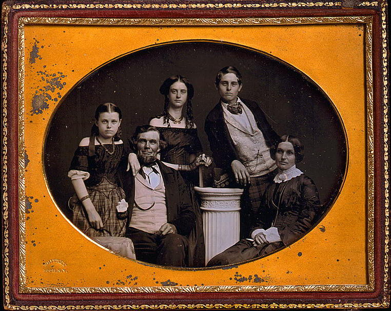
I’ve recently returned to my job behind the counter at the local mercantile. This is good—for all sorts of practical reasons—but requires an adjustment to my research and writing schedule that I’ve not quite figured out. Yet.

Main counter and clerk, 1880s General Store at Old World Wisconsin, July, 2016. Photo by Reed Perkins. Click to open larger image in new window.

I should be back with the conclusion of Infrastructure Week! next week. Meanwhile, here are a few more photos of the General Store at Old World Wisconsin — “big box” retail at its finest, circa 1880.

Continue reading

Monday: Map Day!

The First County Roads, 1841

Infrastructure Week! — part 1

Last week’s Monday: Map Day! discussed the Milwaukee and Superior railroad, and the right-of-way through the middle of the Clark farm property that it purchased from Jonathan and Mary Clark in 1857. Even if you already read it, take another look. I’ve recently updated that post to include corrections and new information from reader Sam Cutler (thanks, Sam!).

Today’s post begins Infrastructure Week! a short series focused on the first infrastructure projects in old Washington/Ozaukee county, beginning with the 1841 appointment of the first county road supervisors and their districts.

Old Washington/Ozaukee County, 1837

In order to proceed with county business, the original county commissioners must have had an authoritative map that showed the official county and township boundaries. I would not be surprised if they owned a copy of the 1837 Topographical map of Wisconsin Territory, showing the lands that had been surveyed by, and were available for purchase from, the federal government. As we discussed earlier, this was the first large-scale map of the Wisconsin Territory based on actual surveys. Here’s a detail from that map, showing old Washington county as the 1841 county commissioners would have understood it:

Continue reading

County Government – Early Records

The Jonathan M. Clark House is located in Mequon, Ozaukee (formerly Washington) County, Wisconsin. In our previous post, Mequon – What’s in a name?, we looked into how Mequon became a political entity and how its goverment evolved from the county system to the town system.

From…which archives?

Where do you look when you’d like to read (and download) the handwritten minutes of the meetings of old Washington county’s commissioners, circa 1841-1846? How about…the Washington Co. Highway Department!

This actually makes more sense than you might think, since many of the county’s earliest decisions and expenditures involved proposing, surveying and cutting roads to connect new settlements to each other, to the rest of Wisconsin Territory, and beyond. So—in a fine example of professional organization and public service—the Washington county highway department has gathered together and put online many of their oldest records.

The County Highway Register was an attempt to search out, correlate, and record all known information concerning the laying out of all roads in the county. Some of these books have not been updated since the mid to late 1950’s. Read the forward in the index to understand how these books were created.

(link)

If you follow the link, you’ll find an long list of pdfs, organized by Washington County towns, that contain the collected official highway records and some of the earliest records of county government.

But…Washington County?

Continue reading

Mequon – What’s in a name?

UPDATED, April 20, 2021 to include another historic misspelling of “Mequon,” this one from the 1837 first official map of Wisconsin.

____________________________

Mequon is the home of the Jonathan M. Clark House. Mequon is a unique name, and its source, pronunciation, spelling—and, occasionally, location—are the source of a fair amount of confusion and error. So I thought I would gather a few pertinent facts about the name that might help readers avoid some of the pitfalls in Mequon research.

As a reminder:

Baldwin, Thomas and J. Thomas, M.D., A New and Complete Gazetteer of the United States […], Philadelphia, 1854, p. 687. Via GoogleBooks.

That’s a pretty accurate, “just the facts,” description of Mequon in 1854. (Although it looks like Gazetteer editors Baldwin and Thomas didn’t get the news that on March 7, 1853, the east part of Washington county—including the Town of Mequon—had split from its parent county to form the new Ozaukee county. And the town vs. township distinction could be more precise, too.)

Continue reading

Monday: Map Day!

1874 map of Washington and Ozaukee Counties

Today’s map is another unique and wonderful map from the University of Wisconsin–Milwaukee, American Geographical Society Digital Map Collection. It is map of Washington and Ozaukee Counties from 1874, and it is packed with information and unique details.

Map of Washington and Ozaukee Counties, Wisconsin 1873-4 / drawn, compiled and published by G.V. Nash & M.G. Tucker ; engraved & printed by J. Knauber & Co. ; colored and mounted by E.M. Harney. University of Wisconsin-MilwaukeeAmerican Geographical Society Digital Map Collection. Full copyright notice here, presented in this post as a public domain item and/or under fair use provisions of U.S. copyright law. Click map to go to the UWM collection and open larger image in new window.

Continue reading

The farm garden

It’s early April, and the growing season is not far off. For a farmer like Jonathan M. Clark, it’s a little early yet for plowing and sowing, but not too early to make plans and sharpen the tools. For a farmer’s wife, like Mary (Turck) Clark, it’s not too soon to think about the farm garden, its crops and layout.

I don’t know if Mary and Jonathan were regular readers of the popular and affordable farmers’ almanacs of their era; I wouldn’t be surprised if they were. There were many to chose from. Perhaps they had a copy of something like:

The Cultivator […], New Series, Vol. VII, Albany, 1850, title page. Click to open larger image in new window.

Continue reading